
Given the persistent convection past 12 hours and recent increase in cyclonic turning near 10N/35W, I think this system has a decent chance (~50-60%) of becoming a TC before reaching the Lesser Antilles. However, I think the EPS members showing a hurricane from the E Caribbean to N of PR are likely overdone.
https://twitter.com/yconsor/status/1691161088128065536
https://twitter.com/yconsor/status/1691317204866813952
https://twitter.com/yconsor/status/1691315522862829568
https://twitter.com/yconsor/status/1691322129629802496
https://twitter.com/yconsor/status/1691372242918150144
https://twitter.com/yconsor/status/1691376653761388544
https://twitter.com/yconsor/status/1691384643583377408
Low Pressure Trough Over the Central Atlantic (Is Invest 99L)
Moderator: S2k Moderators
Forum rules

The posts in this forum are NOT official forecasts and should not be used as such. They are just the opinion of the poster and may or may not be backed by sound meteorological data. They are NOT endorsed by any professional institution or STORM2K. For official information, please refer to products from the National Hurricane Center and National Weather Service.

Re: Low Pressure Forecast to Develop over the Central Atlantic
A lot of conjecture with little consensus. The reasonable takeaway however is that ALL of the models are seriously waking up. Where the primary points of genesis will ultimately occur, will be key in largely defining our Atlantic season. Let's seriously hope we don't begin to see other models chiming in with GFS W. Caribbean or GOM solutions.
2 likes
Personal Forecast Disclaimer:
The posts in this forum are NOT official forecast and should not be used as such. They are just the opinion of the poster and may or may not be backed by sound meteorological data. They are NOT endorsed by any professional institution or storm2k.org. For official information, please refer to the NHC and NWS products.
The posts in this forum are NOT official forecast and should not be used as such. They are just the opinion of the poster and may or may not be backed by sound meteorological data. They are NOT endorsed by any professional institution or storm2k.org. For official information, please refer to the NHC and NWS products.
-
Spacecoast

- Category 2

- Posts: 687
- Joined: Thu Aug 31, 2017 2:03 pm
Re: Low Pressure Forecast to Develop over the Central Atlantic
0z EPS MSLP IQR Range: - shows curve N of Islands

0Z EPS: Trop Storm prob's ~10-22%

0Z EPS: Trop Storm prob's ~10-22%
4 likes

Re: Low Pressure Forecast to Develop over the Central Atlantic
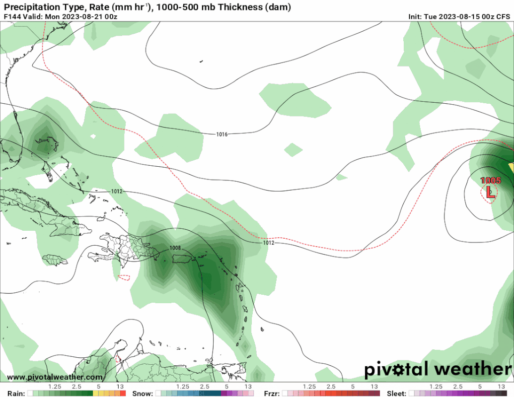
I know the CFS is inferior. But I still thought it was worth mentioning that the 0Z run has a TC form from this 8/24 near the Bahamas that then travels just off NC 8/26.
0 likes
Personal Forecast Disclaimer:
The posts in this forum are NOT official forecasts and should not be used as such. They are just the opinion of the poster and may or may not be backed by sound meteorological data. They are NOT endorsed by any professional institution or storm2k.org. For official information, please refer to the NHC and NWS products.
The posts in this forum are NOT official forecasts and should not be used as such. They are just the opinion of the poster and may or may not be backed by sound meteorological data. They are NOT endorsed by any professional institution or storm2k.org. For official information, please refer to the NHC and NWS products.
-
SFLcane

- S2K Supporter

- Posts: 9606
- Age: 46
- Joined: Sat Jun 05, 2010 1:44 pm
- Location: Lake Worth Florida
Re: Low Pressure Forecast to Develop over the Central Atlantic
LarryWx wrote:I know the CFS is inferior. But I still thought it was worth mentioning that the 0Z run has a TC form from this 8/24 near the Bahamas that then travels just off NC 8/26.
1 likes
-
cycloneye

- Admin

- Posts: 139087
- Age: 67
- Joined: Thu Oct 10, 2002 10:54 am
- Location: San Juan, Puerto Rico
Re: Low Pressure Forecast to Develop over the Central Atlantic
Central Tropical Atlantic:
A tropical wave is producing disorganized showers and thunderstorms
a few hundred miles west-southwest of the Cabo Verde Islands.
Development, if any, of this system should be slow to occur while
it moves generally west-northwestward at about 15 mph across the
tropical Atlantic through the end of the week.
* Formation chance through 48 hours...low...near 0 percent.
* Formation chance through 7 days...low...10 percent.

0 likes
Visit the Caribbean-Central America Weather Thread where you can find at first post web cams,radars
and observations from Caribbean basin members Click Here
and observations from Caribbean basin members Click Here
Re: Low Pressure Forecast to Develop over the Central Atlantic
Some pretty significant model news since the UKMET tends to be conservative:
-The 12Z UKMET has TCG from this in the W MDR on Fri (8/18) and it then hits the Leewards as a TS late on Saturday (8/19).
-It then moves WNW to Hispaniola on Mon (8/21) still as a TS
-It ends up near SE Bahamas as a slowly strengthening TS on Tue (8/22) moving slowly WNW and in a potentially threatening position to the Bahamas/SE US.
NEW TROPICAL CYCLONE FORECAST TO DEVELOP AFTER 78 HOURS
FORECAST POSITION AT T+ 78 : 14.2N 51.4W
LEAD CENTRAL MAXIMUM WIND
VERIFYING TIME TIME POSITION PRESSURE (MB) SPEED (KNOTS)
-------------- ---- -------- ------------- -------------
0000UTC 19.08.2023 84 14.7N 53.5W 1005 30
1200UTC 19.08.2023 96 15.4N 57.4W 1004 34
0000UTC 20.08.2023 108 16.3N 60.5W 1003 37
1200UTC 20.08.2023 120 17.5N 63.5W 1004 40
0000UTC 21.08.2023 132 17.8N 67.0W 1004 37
1200UTC 21.08.2023 144 19.4N 68.7W 1004 38
0000UTC 22.08.2023 156 20.3N 71.2W 1004 37
1200UTC 22.08.2023 168 21.0N 72.9W 1003 39
4 likes
Personal Forecast Disclaimer:
The posts in this forum are NOT official forecasts and should not be used as such. They are just the opinion of the poster and may or may not be backed by sound meteorological data. They are NOT endorsed by any professional institution or storm2k.org. For official information, please refer to the NHC and NWS products.
The posts in this forum are NOT official forecasts and should not be used as such. They are just the opinion of the poster and may or may not be backed by sound meteorological data. They are NOT endorsed by any professional institution or storm2k.org. For official information, please refer to the NHC and NWS products.
-
SFLcane
- S2K Supporter
- Posts: 9606
- Age: 46
- Joined: Sat Jun 05, 2010 1:44 pm
- Location: Lake Worth Florida
Re: Low Pressure Forecast to Develop over the Central Atlantic
LarryWx wrote:Some pretty significant model news since the UKMET tends to be conservative:
-The 12Z UKMET has TCG from this in the W MDR on Fri (8/18) and it then hits the Leewards as a TS late on Saturday (8/19).
-It then moves WNW to Hispaniola on Mon (8/21) still as a TS
-It ends up near SE Bahamas as a slowly strengthening TS on Tue (8/22) moving slowly WNW and in a potentially threatening position to the Bahamas/SE US.
NEW TROPICAL CYCLONE FORECAST TO DEVELOP AFTER 78 HOURS
FORECAST POSITION AT T+ 78 : 14.2N 51.4W
LEAD CENTRAL MAXIMUM WIND
VERIFYING TIME TIME POSITION PRESSURE (MB) SPEED (KNOTS)
-------------- ---- -------- ------------- -------------
0000UTC 19.08.2023 84 14.7N 53.5W 1005 30
1200UTC 19.08.2023 96 15.4N 57.4W 1004 34
0000UTC 20.08.2023 108 16.3N 60.5W 1003 37
1200UTC 20.08.2023 120 17.5N 63.5W 1004 40
0000UTC 21.08.2023 132 17.8N 67.0W 1004 37
1200UTC 21.08.2023 144 19.4N 68.7W 1004 38
0000UTC 22.08.2023 156 20.3N 71.2W 1004 37
1200UTC 22.08.2023 168 21.0N 72.9W 1003 39
1 likes
-
Blown Away

- S2K Supporter
- Posts: 9863
- Joined: Wed May 26, 2004 6:17 am
Re: Low Pressure Forecast to Develop over the Central Atlantic
SFLcane wrote:LarryWx wrote:Some pretty significant model news since the UKMET tends to be conservative:
-The 12Z UKMET has TCG from this in the W MDR on Fri (8/18) and it then hits the Leewards as a TS late on Saturday (8/19).
-It then moves WNW to Hispaniola on Mon (8/21) still as a TS
-It ends up near SE Bahamas as a slowly strengthening TS on Tue (8/22) moving slowly WNW and in a potentially threatening position to the Bahamas/SE US.
NEW TROPICAL CYCLONE FORECAST TO DEVELOP AFTER 78 HOURS
FORECAST POSITION AT T+ 78 : 14.2N 51.4W
LEAD CENTRAL MAXIMUM WIND
VERIFYING TIME TIME POSITION PRESSURE (MB) SPEED (KNOTS)
-------------- ---- -------- ------------- -------------
0000UTC 19.08.2023 84 14.7N 53.5W 1005 30
1200UTC 19.08.2023 96 15.4N 57.4W 1004 34
0000UTC 20.08.2023 108 16.3N 60.5W 1003 37
1200UTC 20.08.2023 120 17.5N 63.5W 1004 40
0000UTC 21.08.2023 132 17.8N 67.0W 1004 37
1200UTC 21.08.2023 144 19.4N 68.7W 1004 38
0000UTC 22.08.2023 156 20.3N 71.2W 1004 37
1200UTC 22.08.2023 168 21.0N 72.9W 1003 39

https://i.postimg.cc/85MGPh7k/hhh.jpg
Not a great spot for a developing strong TS moving WNW...
1 likes
Hurricane Eye Experience: David 79, Irene 99, Frances 04, Jeanne 04, Wilma 05...
Hurricane Brush Experience: Andrew 92, Erin 95, Floyd 99, Matthew 16, Irma 17, Ian 22, Nicole 22…
Hurricane Brush Experience: Andrew 92, Erin 95, Floyd 99, Matthew 16, Irma 17, Ian 22, Nicole 22…
Re: Low Pressure Forecast to Develop over the Central Atlantic
Blown Away wrote:SFLcane wrote:LarryWx wrote:Some pretty significant model news since the UKMET tends to be conservative:
-The 12Z UKMET has TCG from this in the W MDR on Fri (8/18) and it then hits the Leewards as a TS late on Saturday (8/19).
-It then moves WNW to Hispaniola on Mon (8/21) still as a TS
-It ends up near SE Bahamas as a slowly strengthening TS on Tue (8/22) moving slowly WNW and in a potentially threatening position to the Bahamas/SE US.
NEW TROPICAL CYCLONE FORECAST TO DEVELOP AFTER 78 HOURS
FORECAST POSITION AT T+ 78 : 14.2N 51.4W
LEAD CENTRAL MAXIMUM WIND
VERIFYING TIME TIME POSITION PRESSURE (MB) SPEED (KNOTS)
-------------- ---- -------- ------------- -------------
0000UTC 19.08.2023 84 14.7N 53.5W 1005 30
1200UTC 19.08.2023 96 15.4N 57.4W 1004 34
0000UTC 20.08.2023 108 16.3N 60.5W 1003 37
1200UTC 20.08.2023 120 17.5N 63.5W 1004 40
0000UTC 21.08.2023 132 17.8N 67.0W 1004 37
1200UTC 21.08.2023 144 19.4N 68.7W 1004 38
0000UTC 22.08.2023 156 20.3N 71.2W 1004 37
1200UTC 22.08.2023 168 21.0N 72.9W 1003 39
https://i.postimg.cc/85MGPh7k/hhh.jpg
[url]https://i.postimg.cc/mZqbNgsG/Ukmet.jpg [/url]
Not a great spot for a developing strong TS moving WNW...
But the 12Z Euro like the GFS has just about nothing.
0 likes
Personal Forecast Disclaimer:
The posts in this forum are NOT official forecasts and should not be used as such. They are just the opinion of the poster and may or may not be backed by sound meteorological data. They are NOT endorsed by any professional institution or storm2k.org. For official information, please refer to the NHC and NWS products.
The posts in this forum are NOT official forecasts and should not be used as such. They are just the opinion of the poster and may or may not be backed by sound meteorological data. They are NOT endorsed by any professional institution or storm2k.org. For official information, please refer to the NHC and NWS products.
-
SFLcane
- S2K Supporter
- Posts: 9606
- Age: 46
- Joined: Sat Jun 05, 2010 1:44 pm
- Location: Lake Worth Florida
Re: Low Pressure Forecast to Develop over the Central Atlantic
LarryWx wrote:Blown Away wrote:
[url]https://i.postimg.cc/mZqbNgsG/Ukmet.jpg [/url]
Not a great spot for a developing strong TS moving WNW...
But the 12Z Euro like the GFS has just about nothing.
Also has no ridge while the ukmet does.
0 likes
-
lsuhurricane
- Tropical Storm

- Posts: 208
- Joined: Tue Aug 15, 2017 2:53 pm
Re: Low Pressure Forecast to Develop over the Central Atlantic
Larry,
Are we sure that the 12z Euro isnt tracking this same feature, just at a lower latitude?
For reference:

All of these waves are getting confusing
Are we sure that the 12z Euro isnt tracking this same feature, just at a lower latitude?
For reference:
All of these waves are getting confusing
1 likes
-
Blown Away
- S2K Supporter
- Posts: 9863
- Joined: Wed May 26, 2004 6:17 am
Re: Low Pressure Forecast to Develop over the Central Atlantic
Euro starting to act like the GFS with these competing low's in a big gyre.
0 likes
Hurricane Eye Experience: David 79, Irene 99, Frances 04, Jeanne 04, Wilma 05...
Hurricane Brush Experience: Andrew 92, Erin 95, Floyd 99, Matthew 16, Irma 17, Ian 22, Nicole 22…
Hurricane Brush Experience: Andrew 92, Erin 95, Floyd 99, Matthew 16, Irma 17, Ian 22, Nicole 22…
Re: Low Pressure Forecast to Develop over the Central Atlantic
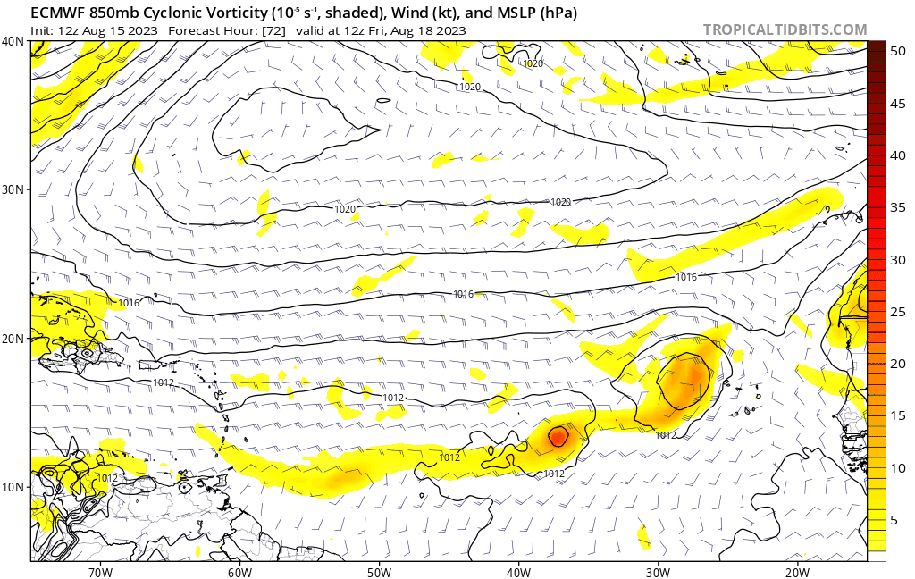
lsuhurricane wrote:Larry,
Are we sure that the 12z Euro isnt tracking this same feature, just at a lower latitude?
For reference:
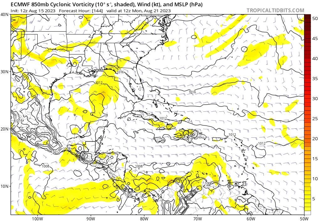
https://i.ibb.co/k6q1CYc/9-km-ECMWF-Global-Pressure-Caribbean-850-h-Pa-Rel-Vorticity-1.gif
All of these waves are getting confusing
Yes, the Euro (and the JMA, too, among others) is tracking the same feature. What I mean by the 12Z Euro having just about nothing is that it has no surface circulation although it has trackable 850 mb vorticity further south. This leads to a very weak low over FL at 240.
The JMA has only a weak reflection at the surface (no circ), but it is a little stronger than the prior 12Z run and pretty much takes the UKMET track from the LAs to the SE Bahamas. You can tell from the widespread 2" of qpf in and near the LAs from this that it has some "oomph" so to speak.
Ever since the August 4th EPS runs, this feature has had some model support and it absolutely needs a bear watch! Yet, the NHC still has TCG chances at only 10%. I'd raise them to 30%.
Last edited by LarryWx on Tue Aug 15, 2023 2:12 pm, edited 1 time in total.
0 likes
Personal Forecast Disclaimer:
The posts in this forum are NOT official forecasts and should not be used as such. They are just the opinion of the poster and may or may not be backed by sound meteorological data. They are NOT endorsed by any professional institution or storm2k.org. For official information, please refer to the NHC and NWS products.
The posts in this forum are NOT official forecasts and should not be used as such. They are just the opinion of the poster and may or may not be backed by sound meteorological data. They are NOT endorsed by any professional institution or storm2k.org. For official information, please refer to the NHC and NWS products.
-
Blown Away
- S2K Supporter
- Posts: 9863
- Joined: Wed May 26, 2004 6:17 am
Re: Low Pressure Forecast to Develop over the Central Atlantic
LarryWx wrote:lsuhurricane wrote:Larry,
Are we sure that the 12z Euro isnt tracking this same feature, just at a lower latitude?
For reference:
https://i.ibb.co/k6q1CYc/9-km-ECMWF-Global-Pressure-Caribbean-850-h-Pa-Rel-Vorticity-1.gif
All of these waves are getting confusing
Yes, the Euro (and the JMA, too, among others) is tracking the same feature. What I mean by the 12Z Euro having just about nothing is that it has no surface circulation although it has trackable 850 mb vorticity further south. This leads to a very weak low over FL at 240.
The JMA has only a weak reflection at the surface (no circ), but it is a little stronger than the prior 12Z run and pretty much takes the UKMET track from the LAs to the SE Bahamas. You can tell from the 2" of qpf in the LAs from this that it has done "oomph" so to speak.
Ever since the August 4th EPS runs, this feature has had some model support and it absolutely needs a bear watch! Yet, the NHC still has TCG chances at only 10%. I'd raise it to 30%.
Larry,
The Euro pulls the TW out of the Caribbean over FL, Ukmet at 168 hrs is at 21.0/72.9. Same feature just Euro is S of Ukmet? Correct?
1 likes
Hurricane Eye Experience: David 79, Irene 99, Frances 04, Jeanne 04, Wilma 05...
Hurricane Brush Experience: Andrew 92, Erin 95, Floyd 99, Matthew 16, Irma 17, Ian 22, Nicole 22…
Hurricane Brush Experience: Andrew 92, Erin 95, Floyd 99, Matthew 16, Irma 17, Ian 22, Nicole 22…
Re: Low Pressure Forecast to Develop over the Central Atlantic
Blown Away wrote:LarryWx wrote:lsuhurricane wrote:Larry,
Are we sure that the 12z Euro isnt tracking this same feature, just at a lower latitude?
For reference:
https://i.ibb.co/k6q1CYc/9-km-ECMWF-Global-Pressure-Caribbean-850-h-Pa-Rel-Vorticity-1.gif
All of these waves are getting confusing
Yes, the Euro (and the JMA, too, among others) is tracking the same feature. What I mean by the 12Z Euro having just about nothing is that it has no surface circulation although it has trackable 850 mb vorticity further south. This leads to a very weak low over FL at 240.
The JMA has only a weak reflection at the surface (no circ), but it is a little stronger than the prior 12Z run and pretty much takes the UKMET track from the LAs to the SE Bahamas. You can tell from the 2" of qpf in the LAs from this that it has done "oomph" so to speak.
Ever since the August 4th EPS runs, this feature has had some model support and it absolutely needs a bear watch! Yet, the NHC still has TCG chances at only 10%. I'd raise it to 30%.
[url]https://i.postimg.cc/66hx4thB/7175ffe8-b5c2-4c97-80e7-f5f494df535b.gif [/url]
Larry,
The Euro pulls the TW out of the Caribbean over FL, Ukmet at 168 hrs is at 21.0/72.9. Same feature just Euro is S of Ukmet? Correct?
Yes, it looks like the same feature to me (more southern route).
0 likes
Personal Forecast Disclaimer:
The posts in this forum are NOT official forecasts and should not be used as such. They are just the opinion of the poster and may or may not be backed by sound meteorological data. They are NOT endorsed by any professional institution or storm2k.org. For official information, please refer to the NHC and NWS products.
The posts in this forum are NOT official forecasts and should not be used as such. They are just the opinion of the poster and may or may not be backed by sound meteorological data. They are NOT endorsed by any professional institution or storm2k.org. For official information, please refer to the NHC and NWS products.
-
SFLcane
- S2K Supporter
- Posts: 9606
- Age: 46
- Joined: Sat Jun 05, 2010 1:44 pm
- Location: Lake Worth Florida
Re: Low Pressure Forecast to Develop over the Central Atlantic
Blown Away wrote:LarryWx wrote:lsuhurricane wrote:Larry,
Are we sure that the 12z Euro isnt tracking this same feature, just at a lower latitude?
For reference:
https://i.ibb.co/k6q1CYc/9-km-ECMWF-Global-Pressure-Caribbean-850-h-Pa-Rel-Vorticity-1.gif
All of these waves are getting confusing
Yes, the Euro (and the JMA, too, among others) is tracking the same feature. What I mean by the 12Z Euro having just about nothing is that it has no surface circulation although it has trackable 850 mb vorticity further south. This leads to a very weak low over FL at 240.
The JMA has only a weak reflection at the surface (no circ), but it is a little stronger than the prior 12Z run and pretty much takes the UKMET track from the LAs to the SE Bahamas. You can tell from the 2" of qpf in the LAs from this that it has done "oomph" so to speak.
Ever since the August 4th EPS runs, this feature has had some model support and it absolutely needs a bear watch! Yet, the NHC still has TCG chances at only 10%. I'd raise it to 30%.
[url]https://i.postimg.cc/66hx4thB/7175ffe8-b5c2-4c97-80e7-f5f494df535b.gif [/url]
Larry,
The Euro pulls the TW out of the Caribbean over FL, Ukmet at 168 hrs is at 21.0/72.9. Same feature just Euro is S of Ukmet? Correct?
Huge upper level low there on the euro not really a tc. Lots of rain for florida perhaps
0 likes
-
Blown Away
- S2K Supporter
- Posts: 9863
- Joined: Wed May 26, 2004 6:17 am
Re: Low Pressure Forecast to Develop over the Central Atlantic
SFLcane wrote:Blown Away wrote:LarryWx wrote:
Yes, the Euro (and the JMA, too, among others) is tracking the same feature. What I mean by the 12Z Euro having just about nothing is that it has no surface circulation although it has trackable 850 mb vorticity further south. This leads to a very weak low over FL at 240.
The JMA has only a weak reflection at the surface (no circ), but it is a little stronger than the prior 12Z run and pretty much takes the UKMET track from the LAs to the SE Bahamas. You can tell from the 2" of qpf in the LAs from this that it has done "oomph" so to speak.
Ever since the August 4th EPS runs, this feature has had some model support and it absolutely needs a bear watch! Yet, the NHC still has TCG chances at only 10%. I'd raise it to 30%.
[url]https://i.postimg.cc/66hx4thB/7175ffe8-b5c2-4c97-80e7-f5f494df535b.gif [/url]
Larry,
The Euro pulls the TW out of the Caribbean over FL, Ukmet at 168 hrs is at 21.0/72.9. Same feature just Euro is S of Ukmet? Correct?
Huge upper level low there on the euro not really a tc. Lots of rain for florida perhaps
12z Euro has our Central Atlantic TW in the Bahamas...
0 likes
Hurricane Eye Experience: David 79, Irene 99, Frances 04, Jeanne 04, Wilma 05...
Hurricane Brush Experience: Andrew 92, Erin 95, Floyd 99, Matthew 16, Irma 17, Ian 22, Nicole 22…
Hurricane Brush Experience: Andrew 92, Erin 95, Floyd 99, Matthew 16, Irma 17, Ian 22, Nicole 22…
Re: Low Pressure Forecast to Develop over the Central Atlantic
SFLcane wrote:Blown Away wrote:LarryWx wrote:
Yes, the Euro (and the JMA, too, among others) is tracking the same feature. What I mean by the 12Z Euro having just about nothing is that it has no surface circulation although it has trackable 850 mb vorticity further south. This leads to a very weak low over FL at 240.
The JMA has only a weak reflection at the surface (no circ), but it is a little stronger than the prior 12Z run and pretty much takes the UKMET track from the LAs to the SE Bahamas. You can tell from the 2" of qpf in the LAs from this that it has done "oomph" so to speak.
Ever since the August 4th EPS runs, this feature has had some model support and it absolutely needs a bear watch! Yet, the NHC still has TCG chances at only 10%. I'd raise it to 30%.
[url]https://i.postimg.cc/66hx4thB/7175ffe8-b5c2-4c97-80e7-f5f494df535b.gif [/url]
Larry,
The Euro pulls the TW out of the Caribbean over FL, Ukmet at 168 hrs is at 21.0/72.9. Same feature just Euro is S of Ukmet? Correct?
Huge upper level low there on the euro not really a tc. Lots of rain for florida perhaps
Not a TC over FL then on the Euro, but the upper low is pulling in moisture/moving lower level vorticity from the Caribbean into it as it looks to me.
0 likes
Personal Forecast Disclaimer:
The posts in this forum are NOT official forecasts and should not be used as such. They are just the opinion of the poster and may or may not be backed by sound meteorological data. They are NOT endorsed by any professional institution or storm2k.org. For official information, please refer to the NHC and NWS products.
The posts in this forum are NOT official forecasts and should not be used as such. They are just the opinion of the poster and may or may not be backed by sound meteorological data. They are NOT endorsed by any professional institution or storm2k.org. For official information, please refer to the NHC and NWS products.
Re: Low Pressure Forecast to Develop over the Central Atlantic
The 12Z EPS still is active with this AEW with ~half the members having TCG though there are fewer H vs the prior run. While having fewer H, it actually is more threatening further west because the tracks are on average further SW with many more going across the LAs and then a good portion of those going well into the Caribbean followed by either dissipation or moving over Hisp/Cuba followed by Bahamas. Some though move NW toward Virgin Islands/PR followed mostly by E of the Bahamas. A few still recurve before the Caribbean and then threaten Bermuda.
Bottom line for 12Z EPS vs 0Z: not as many H but centered closer to the US over Bahamas vs 0Z's mainly E of the Bahamas to Bermuda.
Bottom line for 12Z EPS vs 0Z: not as many H but centered closer to the US over Bahamas vs 0Z's mainly E of the Bahamas to Bermuda.
0 likes
Personal Forecast Disclaimer:
The posts in this forum are NOT official forecasts and should not be used as such. They are just the opinion of the poster and may or may not be backed by sound meteorological data. They are NOT endorsed by any professional institution or storm2k.org. For official information, please refer to the NHC and NWS products.
The posts in this forum are NOT official forecasts and should not be used as such. They are just the opinion of the poster and may or may not be backed by sound meteorological data. They are NOT endorsed by any professional institution or storm2k.org. For official information, please refer to the NHC and NWS products.