Low Pressure in the Northwest Caribbean Sea (Is Invest 93L)

This is the general tropical discussion area. Anyone can take their shot at predicting a storms path.

Moderator: S2k Moderators

Forum rules

The posts in this forum are NOT official forecasts and should not be used as such. They are just the opinion of the poster and may or may not be backed by sound meteorological data. They are NOT endorsed by any professional institution or STORM2K. For official information, please refer to products from the National Hurricane Center and National Weather Service.

Help Support Storm2K
Message
Author
User avatar
chaser1
S2K Supporter
S2K Supporter
Posts: 4681
Age: 63
Joined: Sat Oct 15, 2005 5:59 pm
Location: Longwood, Fl

Re: Possible Development in the Northwestern Caribbean

#261 Postby chaser1 » Thu Aug 24, 2023 11:17 pm

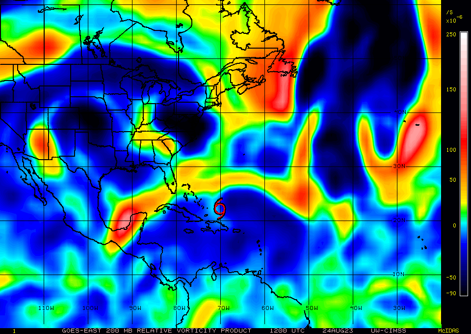
Ianswfl wrote:GFS landfall early Wed weak tropical storm in the 40 to 50mph range around Englewood. Sheared mess. Like a Harvey 1998.

hard to believe this weak. Maybe take the Euro and GFS extremes. Call it 75mph landfall storm maybe.

https://www.tropicaltidbits.com/analysis/models/gfs/2023082500/gfs_ref_frzn_seus_21.png


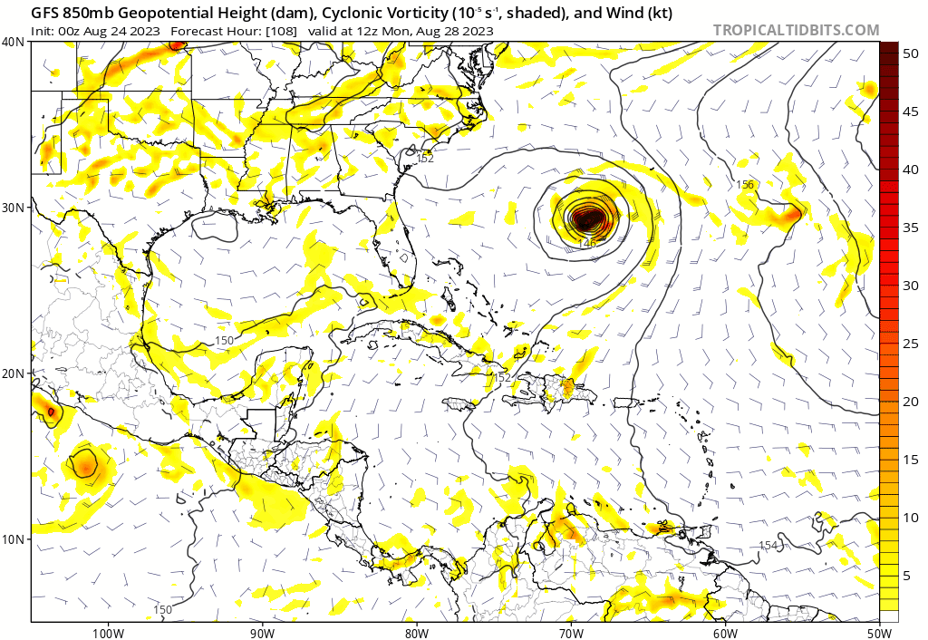
Nope, that's no TS on that frame. There's no evident pressure gradient to speak of.
0 likes   
Personal Forecast Disclaimer:
The posts in this forum are NOT official forecast and should not be used as such. They are just the opinion of the poster and may or may not be backed by sound meteorological data. They are NOT endorsed by any professional institution or storm2k.org. For official information, please refer to the NHC and NWS products.


LarryWx
Category 5
Category 5
Posts: 5702
Joined: Sun Sep 07, 2003 2:04 pm
Location: GA

Re: Possible Development in the Northwestern Caribbean

#262 Postby LarryWx » Thu Aug 24, 2023 11:21 pm

0Z UKMET a bit stronger (60 mph) with similar to 12Z run but slight NW shift. It again landfalls in the FL Big Bend and then goes NE through SE GA and then offshore from SC:

EW TROPICAL CYCLONE FORECAST TO DEVELOP AFTER 66 HOURS
FORECAST POSITION AT T+ 66 : 21.4N 88.3W

LEAD CENTRAL MAXIMUM WIND
VERIFYING TIME TIME POSITION PRESSURE (MB) SPEED (KNOTS)
-------------- ---- -------- ------------- -------------
0000UTC 28.08.2023 72 21.3N 87.9W 1004 22
1200UTC 28.08.2023 84 23.4N 86.2W 1000 43
0000UTC 29.08.2023 96 25.1N 84.9W 996 39
1200UTC 29.08.2023 108 27.6N 84.8W 992 40
0000UTC 30.08.2023 120 29.2N 83.9W 990 43
1200UTC 30.08.2023 132 31.3N 82.0W 993 44
0000UTC 31.08.2023 144 33.1N 78.5W 991 45
1200UTC 31.08.2023 156 34.4N 74.6W 991 48
0000UTC 01.09.2023 168 35.2N 70.6W 993 52
Last edited by LarryWx on Thu Aug 24, 2023 11:22 pm, edited 1 time in total.
1 likes   
Personal Forecast Disclaimer:
The posts in this forum are NOT official forecasts and should not be used as such. They are just the opinion of the poster and may or may not be backed by sound meteorological data. They are NOT endorsed by any professional institution or storm2k.org. For official information, please refer to the NHC and NWS products.

User avatar
cycloneye
Admin
Admin
Posts: 139086
Age: 67
Joined: Thu Oct 10, 2002 10:54 am
Location: San Juan, Puerto Rico

Re: Possible Development in the Northwestern Caribbean

#263 Postby cycloneye » Thu Aug 24, 2023 11:22 pm

00z UIKMET more stronger than 12z. LarryWx.

Image
2 likes   
Visit the Caribbean-Central America Weather Thread where you can find at first post web cams,radars
and observations from Caribbean basin members Click Here

LarryWx
Category 5
Category 5
Posts: 5702
Joined: Sun Sep 07, 2003 2:04 pm
Location: GA

Re: Possible Development in the Northwestern Caribbean

#264 Postby LarryWx » Thu Aug 24, 2023 11:53 pm

The 0Z GEFS is more active than the last few runs. Tue 8/29 is the most active day in FL/SE US with this.
1 likes   
Personal Forecast Disclaimer:
The posts in this forum are NOT official forecasts and should not be used as such. They are just the opinion of the poster and may or may not be backed by sound meteorological data. They are NOT endorsed by any professional institution or storm2k.org. For official information, please refer to the NHC and NWS products.

User avatar
AJC3
Admin
Admin
Posts: 3873
Age: 60
Joined: Tue Aug 31, 2004 7:04 pm
Location: West Melbourne, Florida
Contact:

Re: Possible Development in the Northwestern Caribbean

#265 Postby AJC3 » Fri Aug 25, 2023 12:47 am

Tropical Weather Outlook
NWS National Hurricane Center Miami FL
200 AM EDT Fri Aug 25 2023

Northwestern Caribbean Sea and eastern Gulf of Mexico:
A broad area of low pressure over the northwestern Caribbean Sea
near the northeastern coast of Honduras is producing disorganized
shower and thunderstorm activity. Environmental conditions appear
conducive for gradual development of this system during the next
several days, and a tropical depression is likely to form late this
weekend or early next week while moving generally northward over the
northwestern Caribbean Sea and eastern Gulf of Mexico. Interests in
the Yucatan Peninsula of Mexico, western Cuba, and Florida should
monitor the progress of this system.

* Formation chance through 48 hours...low...20 percent.
* Formation chance through 7 days...high...70 percent.


Image
0 likes   

User avatar
ElectricStorm
Category 5
Category 5
Posts: 4561
Age: 23
Joined: Tue Aug 13, 2019 11:23 pm
Location: Skiatook, OK / Norman, OK

Re: Possible Development in the Northwestern Caribbean

#266 Postby ElectricStorm » Fri Aug 25, 2023 1:13 am

Should be tagged as an invest soon, will be nice to get hurricane model runs
0 likes   
I am in no way a professional. Take what I say with a grain of salt as I could be totally wrong. Please refer to the NHC, NWS, or SPC for official information.

Boomer Sooner!

LarryWx
Category 5
Category 5
Posts: 5702
Joined: Sun Sep 07, 2003 2:04 pm
Location: GA

Re: Possible Development in the Northwestern Caribbean

#267 Postby LarryWx » Fri Aug 25, 2023 1:20 am

At hour 96, the 0Z Euro is weaker than the prior three 12 hourly runs. This may be due to increased Yucatan interaction. Let's see how this run goes further out. Once away from land, it intensifies but it is slower vs recent runs. Instead of Tue, main impact may go into Wednesday.
0 likes   
Personal Forecast Disclaimer:
The posts in this forum are NOT official forecasts and should not be used as such. They are just the opinion of the poster and may or may not be backed by sound meteorological data. They are NOT endorsed by any professional institution or storm2k.org. For official information, please refer to the NHC and NWS products.

LarryWx
Category 5
Category 5
Posts: 5702
Joined: Sun Sep 07, 2003 2:04 pm
Location: GA

Re: Possible Development in the Northwestern Caribbean

#268 Postby LarryWx » Fri Aug 25, 2023 1:35 am

0Z Euro ~995 mb TS landfall FL Big Bend at hour 138. Then to Jacksonville at 992 mb at 144. Heaviest rainfall 4-6" in narrow band part of N FL/SE GA.
0 likes   
Personal Forecast Disclaimer:
The posts in this forum are NOT official forecasts and should not be used as such. They are just the opinion of the poster and may or may not be backed by sound meteorological data. They are NOT endorsed by any professional institution or storm2k.org. For official information, please refer to the NHC and NWS products.

User avatar
GCANE
S2K Supporter
S2K Supporter
Posts: 10787
Joined: Mon Oct 22, 2007 8:03 am

Re: Possible Development in the Northwestern Caribbean

#269 Postby GCANE » Fri Aug 25, 2023 4:27 am

GFS finally hops on the train
1 likes   

USTropics
Category 5
Category 5
Posts: 2414
Joined: Sun Aug 12, 2007 3:45 am
Location: Florida State University

Re: Possible Development in the Northwestern Caribbean

#270 Postby USTropics » Fri Aug 25, 2023 5:00 am

The GFS hasn't handled the evolution of vorticity very well, those are some big corrections in the last 6 runs (less than 5-day forecasts):
Image
0 likes   

User avatar
chris_fit
Category 5
Category 5
Posts: 3078
Joined: Wed Sep 10, 2003 11:58 pm
Location: Tampa Bay Area, FL
Contact:

Re: Possible Development in the Northwestern Caribbean

#271 Postby chris_fit » Fri Aug 25, 2023 5:15 am

06z GFS (and 00z for that matter) caving to the Euro pretty much. Stronger on the 06Z, just north of Tampa.

Image
0 likes   

jlauderdal
S2K Supporter
S2K Supporter
Posts: 6771
Joined: Wed May 19, 2004 5:46 am
Location: NE Fort Lauderdale
Contact:

Re: Possible Development in the Northwestern Caribbean

#272 Postby jlauderdal » Fri Aug 25, 2023 5:26 am

USTropics wrote:The GFS hasn't handled the evolution of vorticity very well, those are some big corrections in the last 6 runs (less than 5-day forecasts):
https://i.postimg.cc/R0LD3GyV/gfs-z850-vort-watl-fh78-trend.gif

This was a big loss for the GFS, Euro sniffed it out last Sunday but way too intense and lost it but still a win for the euro, Canadian and icon. Lets see how they do on the leadup to landfall.
0 likes   

User avatar
Nimbus
Category 5
Category 5
Posts: 4928
Joined: Mon Jul 19, 2004 10:54 am

Re: Possible Development in the Northwestern Caribbean

#273 Postby Nimbus » Fri Aug 25, 2023 5:36 am

06Z GFS now showing a closed low in the same position as Euro off Tampa but a little faster track for the GFS.
Both models have 250 MB winds outlining the high to the east with track rounding the western periphery.

There is a trough further north but it isn't digging much in either the 00Z or 06 Z GFS/Euro.
That is usually a low shear setup conducive for development so GFS may explode this in later runs.

I'll check back in Active forumn for the invest later today.
1 likes   

User avatar
NDG
S2K Supporter
S2K Supporter
Posts: 14933
Joined: Sun Jul 09, 2006 10:14 pm
Location: Orlando, FL

Re: Possible Development in the Northwestern Caribbean

#274 Postby NDG » Fri Aug 25, 2023 6:01 am

He had no option but the Tweet about it, it would had been nice if he would had given props to the EC :wink:

 https://twitter.com/NDGMETCHEF/status/1695026534623433062


3 likes   

User avatar
gatorcane
S2K Supporter
S2K Supporter
Posts: 23499
Age: 46
Joined: Sun Mar 13, 2005 3:54 pm
Location: Boca Raton, FL

Re: Possible Development in the Northwestern Caribbean

#275 Postby gatorcane » Fri Aug 25, 2023 6:06 am

Had a feeling the GFS would jump on board. Now the question is how strong. Water temps are in the low 90s in parts of the Eastern Gulf. For now models are not blowing it up.
1 likes   

USTropics
Category 5
Category 5
Posts: 2414
Joined: Sun Aug 12, 2007 3:45 am
Location: Florida State University

Re: Possible Development in the Northwestern Caribbean

#276 Postby USTropics » Fri Aug 25, 2023 6:14 am

While the models are useful tools, we can now start to follow the evolution of the actual system by analyzing the different levels of the atmosphere. At the lower levels, the northern vorticity lobe is entering the western Caribbean (which should lead to an invest tag later today). This will drag the southern lobe over Central America later tonight, where some type of merger/dissipation of the southern lobe will occur. How far west this northern lobe gets will be key in the long term tracks (over Yucatan? just off the coast? farther west?):
Image

We can also see the northern lobe becoming the dominant feature now by analyzing the evolution of the mid-level vorticity over the past 24 hours:
Image

The upper-level environment also appears conducive for development, with defined radial outflow setting up over the GOM:
Image
5 likes   

User avatar
SFLcane
S2K Supporter
S2K Supporter
Posts: 9606
Age: 46
Joined: Sat Jun 05, 2010 1:44 pm
Location: Lake Worth Florida

Re: Possible Development in the Northwestern Caribbean

#277 Postby SFLcane » Fri Aug 25, 2023 6:14 am

Half’s models are into the Naples area 991mb.

Image
0 likes   

User avatar
NDG
S2K Supporter
S2K Supporter
Posts: 14933
Joined: Sun Jul 09, 2006 10:14 pm
Location: Orlando, FL

Re: Possible Development in the Northwestern Caribbean

#278 Postby NDG » Fri Aug 25, 2023 6:24 am

06z GEFS ensembles finally wake up.

Image
2 likes   

caneman
Category 5
Category 5
Posts: 1178
Joined: Fri Sep 05, 2014 5:44 am
Location: Clearwater Beach, Fl

Re: Possible Development in the Northwestern Caribbean

#279 Postby caneman » Fri Aug 25, 2023 6:25 am

SFLcane wrote:Half’s models are into the Naples area 991mb.

https://i.postimg.cc/TYRFJmzt/IMG-7501.gif


I'm not seeing any reliable models taking it that far South. Tampa to Big Bend but I don't trust any of them until we have an actual system to track
0 likes   

User avatar
toad strangler
S2K Supporter
S2K Supporter
Posts: 4162
Joined: Sun Jul 28, 2013 3:09 pm
Location: Earth
Contact:

Re: Possible Development in the Northwestern Caribbean

#280 Postby toad strangler » Fri Aug 25, 2023 6:29 am

What the heck is the Half's model? :lol:

Anyway, whatever comes of this there won't be much waiting. Everyone on the Gulf Coast should have all their supplies by now BUT IF YOU DON'T .... in FLorida, the second tax holiday for storm products starts tomorrow!

https://floridarevenue.com/DisasterPrep/Documents/2023/DPposter11X17.pdf
0 likes   


Return to “Talkin' Tropics”

Who is online

Users browsing this forum: Cat5James, zzzh and 233 guests