


2024 Indicators: SST's, MSLP, Shear, SAL, Steering, Instability (Day 16+ Climate Models)
Moderator: S2k Moderators
Forum rules

The posts in this forum are NOT official forecasts and should not be used as such. They are just the opinion of the poster and may or may not be backed by sound meteorological data. They are NOT endorsed by any professional institution or STORM2K. For official information, please refer to products from the National Hurricane Center and National Weather Service.
Re: 2024 Indicators: SST's, MSLP, Shear, SAL, Steering, Instability (Day 16+ Climate Models)
The hype on this season feels a little bit premature. It's still March, folks... I'm not saying it'll "bust" but there's so much time for things to change. For all we know, July could be chok-a-blok with SAL that doesn't depart until mid-August. Or the + AMO could collapse. Or SSTs near Newfoundland could sharply rise by midsummer, leading to "wave-breaking". So many unanswered questions still, so we need to have patience and watch how things play out.
2 likes
-
Ivanhater

- Storm2k Moderator

- Posts: 10852
- Age: 37
- Joined: Fri Jul 01, 2005 8:25 am
- Location: Pensacola
Re: 2024 Indicators: SST's, MSLP, Shear, SAL, Steering, Instability (Day 16+ Climate Models)
ThomasW wrote:The hype on this season feels a little bit premature. It's still March, folks... I'm not saying it'll "bust" but there's so much time for things to change. For all we know, July could be chok-a-blok with SAL that doesn't depart until mid-August. Or the + AMO could collapse. Or SSTs near Newfoundland could sharply rise by midsummer, leading to "wave-breaking". So many unanswered questions still, so we need to have patience and watch how things play out.
I mean tomorrow is April and only 8 weeks until hurricane season
1 likes
Michael

Re: 2024 Indicators: SST's, MSLP, Shear, SAL, Steering, Instability (Day 16+ Climate Models)
Ivanhater wrote:ThomasW wrote:The hype on this season feels a little bit premature. It's still March, folks... I'm not saying it'll "bust" but there's so much time for things to change. For all we know, July could be chok-a-blok with SAL that doesn't depart until mid-August. Or the + AMO could collapse. Or SSTs near Newfoundland could sharply rise by midsummer, leading to "wave-breaking". So many unanswered questions still, so we need to have patience and watch how things play out.
I mean tomorrow is April and only 8 weeks until hurricane season
But we all know that June typically just has a tropical storm or two and July may or may not have a major hurricane depending on SAL and random variation. Many otherwise active seasons completely miss July , other seasons like 2005 or 2008 it is the opposite. Still other seasons have normal summer activity but markedly below average in the heart of hurricane season (2013). Those early storms (before the middle of August) add to the count but rarely produce much ACE. Hurricane season is a human construct. We have plenty of time left before we hit the climatological maximum period of activity. We are just now leaving the month with the coolest SSTs in the Atlantic and highest SSTs in the southern hemisphere. Hurricane season doesnt peak until we approach the month with maximum average Atlantic SSTs, which is September.
I remember a similar setup materialized in 2010. The favorability did not fall apart and the season ended as hyperactive, just not at the level some were expecting. This is partly because it produced below normal activity all summer (besides Alex in June) until the lid came off in the last week of August. Until then, it was a struggle for every system to even try to exist. It was a lackluster start to what was supposed to be a very big season(which again, it became such in the fall). If summer 2010 managed even a normal level of activity, it would be a Greek letter hyperactive season and likely be the second most active season pre-2020.
In expecting an active season but Id still be amazed if we used the auxiliary list.
Last edited by Dean_175 on Sun Mar 31, 2024 11:03 am, edited 5 times in total.
2 likes
All posts by Dean_175 are NOT official forecasts and should not be used as such. They are just the opinion of the poster and may or may not be backed by sound meteorological data. They are NOT endorsed by any professional institution or storm2k.org. For official information, please refer to the NHC and NWS products.
-
WeatherBoy2000
- Tropical Depression

- Posts: 88
- Joined: Mon Apr 10, 2023 9:29 am
Re: 2024 Indicators: SST's, MSLP, Shear, SAL, Steering, Instability (Day 16+ Climate Models)
ThomasW wrote:The hype on this season feels a little bit premature. It's still March, folks... I'm not saying it'll "bust" but there's so much time for things to change. For all we know, July could be chok-a-blok with SAL that doesn't depart until mid-August. Or the + AMO could collapse. Or SSTs near Newfoundland could sharply rise by midsummer, leading to "wave-breaking". So many unanswered questions still, so we need to have patience and watch how things play out.
The latest climate model runs and Klotzbach's forecast come out this week. Although never 100% foolproof, the forecasts that come out around now are typically good at giving a general sense of what's ahead. If models and Klotzbach say active or very active season, that'll more than likely be the case. I personally don't see a reason for them to predict anything but above average activity, record warm Atlantic paired with an upcoming la nina.
2 likes
Re: 2024 Indicators: SST's, MSLP, Shear, SAL, Steering, Instability (Day 16+ Climate Models)
Ivanhater wrote:ThomasW wrote:The hype on this season feels a little bit premature. It's still March, folks... I'm not saying it'll "bust" but there's so much time for things to change. For all we know, July could be chok-a-blok with SAL that doesn't depart until mid-August. Or the + AMO could collapse. Or SSTs near Newfoundland could sharply rise by midsummer, leading to "wave-breaking". So many unanswered questions still, so we need to have patience and watch how things play out.
I mean tomorrow is April and only 8 weeks until hurricane season
Officially, season begins June 1, but most years it doesn't begin "for real" until August 20th or thereabouts. RIP. Dr. Bill Gray
2 likes
Re: 2024 Indicators: SST's, MSLP, Shear, SAL, Steering, Instability (Day 16+ Climate Models)
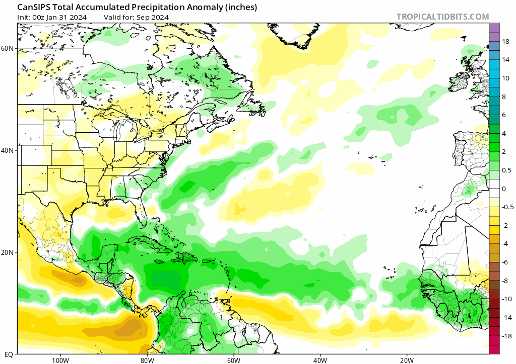
New Cansips is out, things still look very favorable though weaker compared to the last run.
One thing I noticed is the South Atlantic sst:
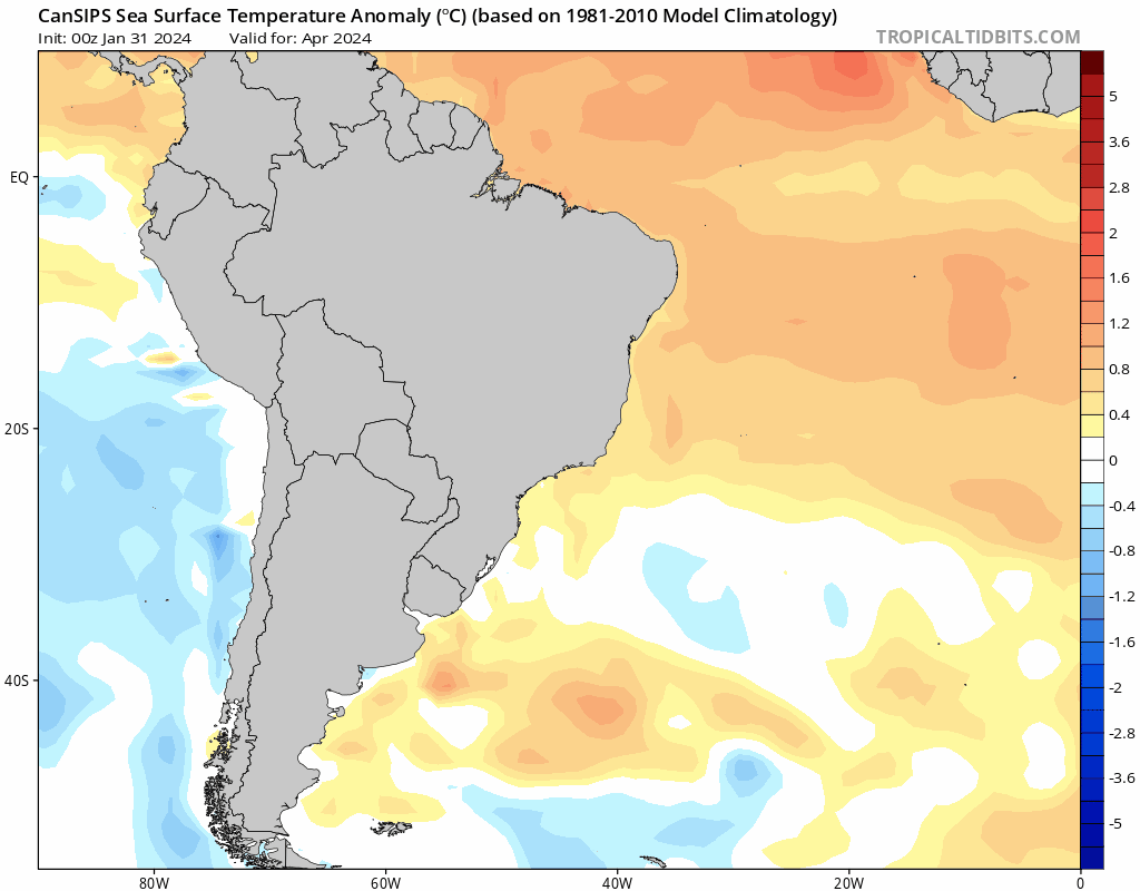
Most models fail to capture the warmth in the south atlantic and now trend toward less +AMM and a more suppressed ITCZ.
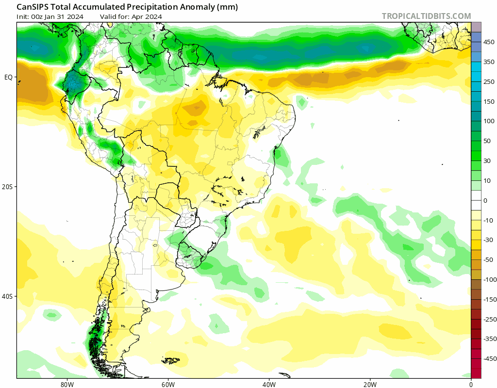
You can see the wet anomaly shifts to the south of equator while the dry anomaly shifts to the north of equator.
Typically the AMM is phase-locked in the spring, and if the south atlantic does not cool down in the next 2 month, we are going to see enhanced trades over east atlantic/mdr this summer.
One thing I noticed is the South Atlantic sst:
Most models fail to capture the warmth in the south atlantic and now trend toward less +AMM and a more suppressed ITCZ.
You can see the wet anomaly shifts to the south of equator while the dry anomaly shifts to the north of equator.
Typically the AMM is phase-locked in the spring, and if the south atlantic does not cool down in the next 2 month, we are going to see enhanced trades over east atlantic/mdr this summer.
2 likes
-
DorkyMcDorkface

- Category 2

- Posts: 699
- Age: 26
- Joined: Mon Sep 30, 2019 1:32 pm
- Location: Mid-Atlantic
Re: 2024 Indicators: SST's, MSLP, Shear, SAL, Steering, Instability (Day 16+ Climate Models)
zzzh wrote:New Cansips is out, things still look very favorable though weaker compared to the last run.
One thing I noticed is the South Atlantic sst:
https://i.postimg.cc/2yf3pNyj/cansips-ssta-noice-samer-fh0-trend.gif
Most models fail to capture the warmth in the south atlantic and now trend toward less +AMM and a more suppressed ITCZ.
https://i.postimg.cc/Kz8LVKGN/cansips-apcpna-month-samer-fh0-trend.gif
You can see the wet anomaly shifts to the south of equator while the dry anomaly shifts to the north of equator.
Typically the AMM is phase-locked in the spring, and if the south atlantic does not cool down in the next 2 month, we are going to see enhanced trades over east atlantic/mdr this summer.
That's an interesting adjustment/caveat. Doesn't look like it cools the SATL that much by peak either, and you can see the resulting ITCZ shifting equatorward in this period as well as a result.


MDR remains more or less the same in terms of well-above avg warmth so it doesn't appear to be too much of a negating factor, but it is probably worth keeping a watchful eye on how SSTs in the SATL evolve, especially if the other guidance follows suit in showing this.


3 likes
Floyd 1999 | Isabel 2003 | Hanna 2008 | Irene 2011 | Sandy 2012 | Isaias 2020
-
cycloneye

- Admin

- Posts: 139093
- Age: 67
- Joined: Thu Oct 10, 2002 10:54 am
- Location: San Juan, Puerto Rico
Re: 2024 Indicators: SST's, MSLP, Shear, SAL, Steering, Instability (Day 16+ Climate Models) April (CanSIPS is up)
My take is this. Is interesting this run that throws a little curveball to the forecasts from the experts already out, that have been with very high numbers and also the ACE. It has the ENSO transition a little bit slower and by ASO, it has weak La Niña, instead of a stronger one. That warmer SATL will be interesting to watch and also, how the Canary Current does. But still are other models that will come out in the comming days,such as NMME, C3S, ECMWF, and let's see if there are small changes as CanSIPS has.
1 likes
Visit the Caribbean-Central America Weather Thread where you can find at first post web cams,radars
and observations from Caribbean basin members Click Here
and observations from Caribbean basin members Click Here

Re: 2024 Indicators: SST's, MSLP, Shear, SAL, Steering, Instability (Day 16+ Climate Models) April (CanSIPS is up)
Slight southward shift of the Easternmost MDR is subtle, yet interesting if future forecast trends reinforce the idea of a suppressed far east Atlantic. If that were to occur one potential outcome could be a further westward "flashpoint" for Tropical genesis. That might slightly detract from a lot of folks ACE guestimates but could further play into the notion of an especially busy number of storm tracts beginning near or traversing over the Lesser Antilles as Tropical systems track anywhere from West to Northwest from there. Keep in mind,, the further west storms form - the less mid longitude recurvatures as a result of any mid-Atlantic troughiness that would otherwise enhance poleward motion. We certainly need some time yet to get a better feel for where, how strong, and the broad scale orientation of how W. Atlantic mid level height flow might set up.
2 likes
Personal Forecast Disclaimer:
The posts in this forum are NOT official forecast and should not be used as such. They are just the opinion of the poster and may or may not be backed by sound meteorological data. They are NOT endorsed by any professional institution or storm2k.org. For official information, please refer to the NHC and NWS products.
The posts in this forum are NOT official forecast and should not be used as such. They are just the opinion of the poster and may or may not be backed by sound meteorological data. They are NOT endorsed by any professional institution or storm2k.org. For official information, please refer to the NHC and NWS products.


Re: 2024 Indicators: SST's, MSLP, Shear, SAL, Steering, Instability (Day 16+ Climate Models)
zzzh wrote:New Cansips is out, things still look very favorable though weaker compared to the last run.
One thing I noticed is the South Atlantic sst:
https://i.postimg.cc/2yf3pNyj/cansips-ssta-noice-samer-fh0-trend.gif
Most models fail to capture the warmth in the south atlantic and now trend toward less +AMM and a more suppressed ITCZ.
https://i.postimg.cc/Kz8LVKGN/cansips-apcpna-month-samer-fh0-trend.gif
You can see the wet anomaly shifts to the south of equator while the dry anomaly shifts to the north of equator.
Typically the AMM is phase-locked in the spring, and if the south atlantic does not cool down in the next 2 month, we are going to see enhanced trades over east atlantic/mdr this summer.
Didn't 2021 feature an even stronger Atlantic Nino? That year gave us two long-tracking MDR majors, Larry and Sam, with a more impressive MDR season than any other since 2020 (or even since 2018), even though that came at the cost of late-season activity.
0 likes
Re: 2024 Indicators: SST's, MSLP, Shear, SAL, Steering, Instability (Day 16+ Climate Models) April (CanSIPS is up)
More amateur guesses here.
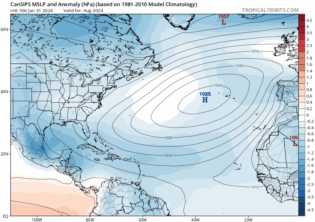
It appears that compared to the January and February runs, the March CanSIPS run also features stronger ridging in August:
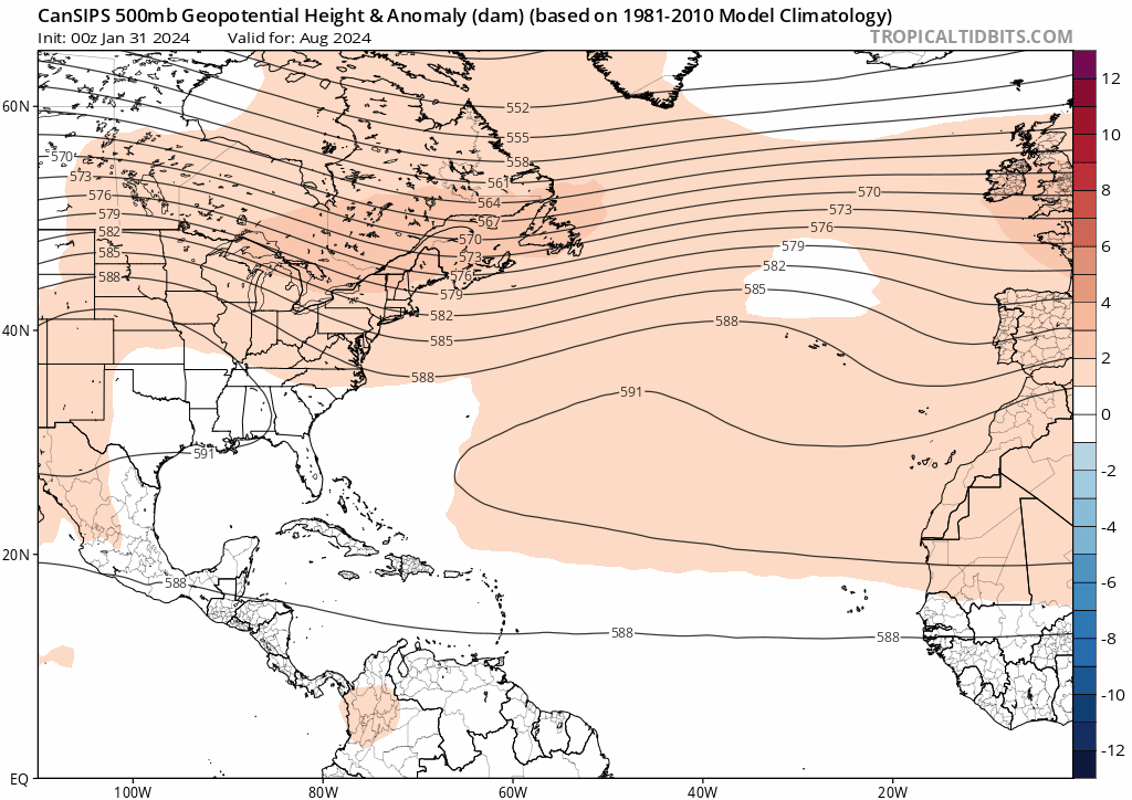
This may also explain why the (western) subtropics trended warmer for ASO. Thus, besides an ITCZ further south, another possible explanation of the shift in precipitation anomalies is waves/storms being pushed further south and west. While it may result in less of an +AMO signature, it obviously increases the risk of land impacts.
... Or is it?
Breaking down the precip anomalies month by month is when things get a bit more interesting and weirder. For August, there indeed seems to be a shift towards tracks further south and west:
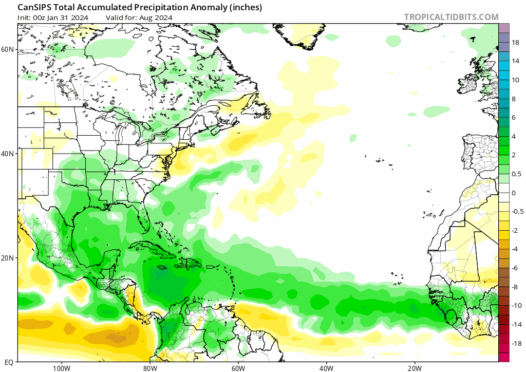
But September shows the opposite, with a more recurve-heavy pattern than the previous two runs...? Also notice that unlike August, the wet anomalies in the eastern MDR were not pulled further south from the February run to the March run - if anything, it was slightly further north!
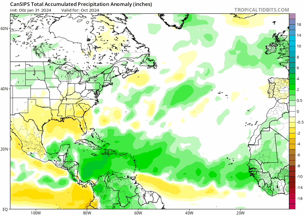
October then shows a slightly wetter Caribbean, unlike 2021 (as I mentioned above) where it unexpectedly shut down:
MSLP also shows a slightly higher pressures in the MDR in August, and then the opposite in September:
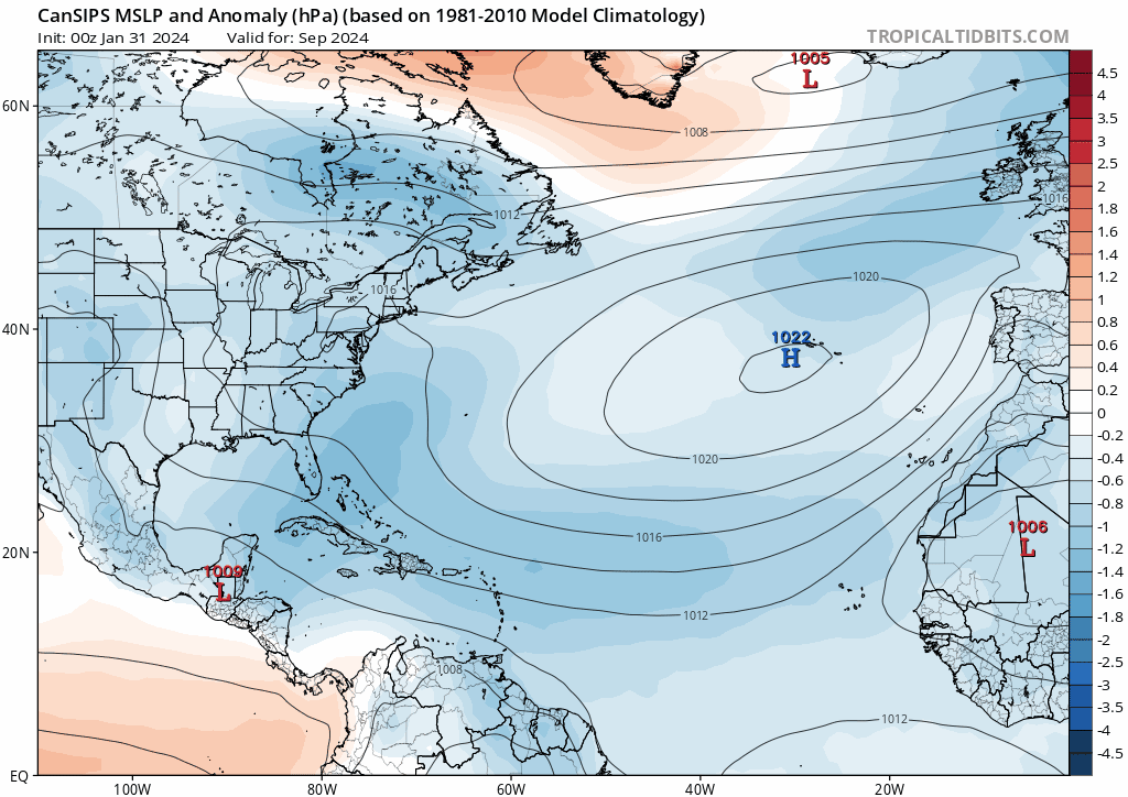
Is the model picking up some sort of pattern change between August and September, that results in a more west-based August but a more recurve-heavy September (compared to the previous run)?
------------
As for the slower Nina transition, I wouldn't take it as a huge negative if any. Not only does the output still look like at least (weak to)moderate Nina to me, but IIRC someone said before that many of the busiest seasons happen in weak or moderate Ninas, not strong Ninas.
It appears that compared to the January and February runs, the March CanSIPS run also features stronger ridging in August:
This may also explain why the (western) subtropics trended warmer for ASO. Thus, besides an ITCZ further south, another possible explanation of the shift in precipitation anomalies is waves/storms being pushed further south and west. While it may result in less of an +AMO signature, it obviously increases the risk of land impacts.
... Or is it?
Breaking down the precip anomalies month by month is when things get a bit more interesting and weirder. For August, there indeed seems to be a shift towards tracks further south and west:
But September shows the opposite, with a more recurve-heavy pattern than the previous two runs...? Also notice that unlike August, the wet anomalies in the eastern MDR were not pulled further south from the February run to the March run - if anything, it was slightly further north!
October then shows a slightly wetter Caribbean, unlike 2021 (as I mentioned above) where it unexpectedly shut down:
MSLP also shows a slightly higher pressures in the MDR in August, and then the opposite in September:
Is the model picking up some sort of pattern change between August and September, that results in a more west-based August but a more recurve-heavy September (compared to the previous run)?
------------
As for the slower Nina transition, I wouldn't take it as a huge negative if any. Not only does the output still look like at least (weak to)moderate Nina to me, but IIRC someone said before that many of the busiest seasons happen in weak or moderate Ninas, not strong Ninas.
0 likes
-
AnnularCane

- S2K Supporter

- Posts: 2635
- Joined: Thu Jun 08, 2006 9:18 am
- Location: Wytheville, VA
Re: 2024 Indicators: SST's, MSLP, Shear, SAL, Steering, Instability (Day 16+ Climate Models)
2020 had wavebreaking too? I never heard the term until 2022.
And I'm still not entirely clear on exactly what it is.
And I'm still not entirely clear on exactly what it is.
2 likes
"But it never rained rain. It never snowed snow. And it never blew just wind. It rained things like soup and juice. It snowed mashed potatoes and green peas. And sometimes the wind blew in storms of hamburgers." -- Judi Barrett, Cloudy with a Chance of Meatballs
-
mixedDanilo.E
- Tropical Depression
- Posts: 72
- Joined: Sun Nov 21, 2021 8:00 am
Re: 2024 Indicators: SST's, MSLP, Shear, SAL, Steering, Instability (Day 16+ Climate Models)
I noticed that the CanSIPS has downtrended by a hair in a few of the anomalies but I'm gonna say it right now: do not worry about it. The overall idea is the same, potent La Niña, very warm atlantic and very active precip look throughout the deep tropics and western atlantic.
0 likes
-
AnnularCane
- S2K Supporter
- Posts: 2635
- Joined: Thu Jun 08, 2006 9:18 am
- Location: Wytheville, VA
Re: 2024 Indicators: SST's, MSLP, Shear, SAL, Steering, Instability (Day 16+ Climate Models)
We're past the SPB? How long does it go to? (I thought till late May.)
0 likes
"But it never rained rain. It never snowed snow. And it never blew just wind. It rained things like soup and juice. It snowed mashed potatoes and green peas. And sometimes the wind blew in storms of hamburgers." -- Judi Barrett, Cloudy with a Chance of Meatballs

Re: 2024 Indicators: SST's, MSLP, Shear, SAL, Steering, Instability (Day 16+ Climate Models)
Teban54 wrote:zzzh wrote:New Cansips is out, things still look very favorable though weaker compared to the last run.
One thing I noticed is the South Atlantic sst:
https://i.postimg.cc/2yf3pNyj/cansips-ssta-noice-samer-fh0-trend.gif
Most models fail to capture the warmth in the south atlantic and now trend toward less +AMM and a more suppressed ITCZ.
https://i.postimg.cc/Kz8LVKGN/cansips-apcpna-month-samer-fh0-trend.gif
You can see the wet anomaly shifts to the south of equator while the dry anomaly shifts to the north of equator.
Typically the AMM is phase-locked in the spring, and if the south atlantic does not cool down in the next 2 month, we are going to see enhanced trades over east atlantic/mdr this summer.
Didn't 2021 feature an even stronger Atlantic Nino? That year gave us two long-tracking MDR majors, Larry and Sam, with a more impressive MDR season than any other since 2020 (or even since 2018), even though that came at the cost of late-season activity.
2021 had a lower-latitude ITCZ than 2020 if I’m not mistaken. Also the waves were tighter and less broad. That allowed Larry and Sam to form and become high-ACE majors, but it then led to every late-season wave running into South America.
0 likes
Irene '11 Sandy '12 Hermine '16 5/15/2018 Derecho Fay '20 Isaias '20 Elsa '21 Henri '21 Ida '21
I am only a meteorology enthusiast who knows a decent amount about tropical cyclones. Look to the professional mets, the NHC, or your local weather office for the best information.
I am only a meteorology enthusiast who knows a decent amount about tropical cyclones. Look to the professional mets, the NHC, or your local weather office for the best information.
-
AutoPenalti
- Category 5

- Posts: 3949
- Age: 27
- Joined: Mon Aug 17, 2015 4:16 pm
- Location: Ft. Lauderdale, Florida
Re: 2024 Indicators: SST's, MSLP, Shear, SAL, Steering, Instability (Day 16+ Climate Models)
AnnularCane wrote:We're past the SPB? How long does it go to? (I thought till late May.)
From NotSparta
Coming off a strong El Nino, there is no spring barrier. La Nina is on the way, the question is how strong it gets
2 likes
The posts in this forum are NOT official forecasts and should not be used as such. They are just the opinion of the poster and may or may not be backed by sound meteorological data. They are NOT endorsed by any professional institution or STORM2K. For official information, please refer to products from the NHC and NWS.
Model Runs Cheat Sheet:
GFS (5:30 AM/PM, 11:30 AM/PM)
HWRF, GFDL, UKMET, NAVGEM (6:30-8:00 AM/PM, 12:30-2:00 AM/PM)
ECMWF (1:45 AM/PM)
TCVN is a weighted averaged
-
mixedDanilo.E
- Tropical Depression
- Posts: 72
- Joined: Sun Nov 21, 2021 8:00 am
Re: 2024 Indicators: SST's, MSLP, Shear, SAL, Steering, Instability (Day 16+ Climate Models)
AnnularCane wrote:We're past the SPB? How long does it go to? (I thought till late May.)
We're usually past the SPB after March. This year there wasn't much of one.
0 likes
Who is online
Users browsing this forum: duilaslol, HurricaneFan, KirbyDude25, ljmac75, StPeteMike, weatherwindow and 114 guests