http://manati.wwb.noaa.gov/dataimages21 ... MBas32.png
Not entirely unusual though. These do occur from time to time, but they hardly survive across the Atlantic
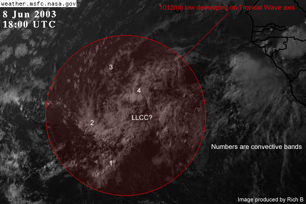
Closed tropical low near Africa
Moderator: S2k Moderators
Forum rules

The posts in this forum are NOT official forecasts and should not be used as such. They are just the opinion of the poster and may or may not be backed by sound meteorological data. They are NOT endorsed by any professional institution or STORM2K. For official information, please refer to products from the National Hurricane Center and National Weather Service.
-
Stormsfury

- Category 5

- Posts: 10549
- Age: 51
- Joined: Wed Feb 05, 2003 6:27 pm
- Location: Summerville, SC
Especially this time of year ...
(I hate 6 hr intervals for Meteosat)
http://www.ssd.noaa.gov/PS/TROP/DATA/RT ... -loop.html
(I hate 6 hr intervals for Meteosat)
http://www.ssd.noaa.gov/PS/TROP/DATA/RT ... -loop.html
0 likes
-
cycloneye

- Admin

- Posts: 139162
- Age: 67
- Joined: Thu Oct 10, 2002 10:54 am
- Location: San Juan, Puerto Rico
http://flhurricane.com/cyclone/files/6608-Image1.gif
It will be very difficult for it to survive all the way from africa to the caribbean as hostil conditions prevail in the tropical atlantic.If it were august or september it would be a TS or a cane but I will watch it neverless to see how far it goes.
It will be very difficult for it to survive all the way from africa to the caribbean as hostil conditions prevail in the tropical atlantic.If it were august or september it would be a TS or a cane but I will watch it neverless to see how far it goes.
Last edited by cycloneye on Sun Jun 08, 2003 3:29 pm, edited 1 time in total.
0 likes
Visit the Caribbean-Central America Weather Thread where you can find at first post web cams,radars
and observations from Caribbean basin members Click Here
and observations from Caribbean basin members Click Here
-
Anonymous
It's not rare for early June, but it isn't common either. Anyways, it doesn't stand a chance with the dry air and strong westerly shear its moving into. Once a positive MJO phase moves in the region in a week or so, the ITCZ should die down quite a bit.
On a side note, remember what happened on June 24, 2000? Tropical Depression #2 out in the east Atlantic...see...it CAN happen.

On a side note, remember what happened on June 24, 2000? Tropical Depression #2 out in the east Atlantic...see...it CAN happen.
Last edited by Anonymous on Sun Jun 08, 2003 3:16 pm, edited 1 time in total.
0 likes
-
Anonymous
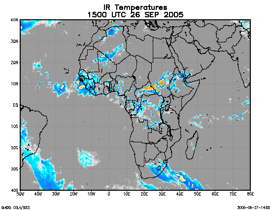
These images update a lot faster.
http://www.cpc.ncep.noaa.gov/products/f ... africa.gif
http://wwwghcc.msfc.nasa.gov/cgi-bin/ge ... olor=white[/url]
http://www.cpc.ncep.noaa.gov/products/f ... africa.gif
http://wwwghcc.msfc.nasa.gov/cgi-bin/ge ... olor=white[/url]
0 likes
-
weatherlover427
-
Anonymous
-
Anonymous
-
weatherlover427

-
wx247

- S2K Supporter

- Posts: 14279
- Age: 40
- Joined: Wed Feb 05, 2003 10:35 pm
- Location: Monett, Missouri
- Contact:
Interesting development. And thanks for the link TropicalWxWatcher... I hate the 6 hr. wait as well. Sometimes it drives me up the wall. 
0 likes
Personal Forecast Disclaimer:
The posts in this forum are NOT official forecast and should not be used as such. They are just the opinion of the poster and may or may not be backed by sound meteorological data. They are NOT endorsed by any professional institution or storm2k.org. For official information, please refer to the NHC and NWS products.
The posts in this forum are NOT official forecast and should not be used as such. They are just the opinion of the poster and may or may not be backed by sound meteorological data. They are NOT endorsed by any professional institution or storm2k.org. For official information, please refer to the NHC and NWS products.
-
southerngale

- Retired Staff

- Posts: 27420
- Joined: Thu Oct 10, 2002 1:27 am
- Location: Southeast Texas (Beaumont area)

 my Cowboys
 -
Guest
-
Anonymous
-
Rainband
-
cycloneye
- Admin
- Posts: 139162
- Age: 67
- Joined: Thu Oct 10, 2002 10:54 am
- Location: San Juan, Puerto Rico
It is interesting that convection has increased near the low.But shear awaits it at 40w and the question is if it will survive.
0 likes
Visit the Caribbean-Central America Weather Thread where you can find at first post web cams,radars
and observations from Caribbean basin members Click Here
and observations from Caribbean basin members Click Here

Who is online
Users browsing this forum: duilaslol and 169 guests