Katrina Strengthening

This is the general tropical discussion area. Anyone can take their shot at predicting a storms path.

Moderator: S2k Moderators

Forum rules

The posts in this forum are NOT official forecasts and should not be used as such. They are just the opinion of the poster and may or may not be backed by sound meteorological data. They are NOT endorsed by any professional institution or STORM2K. For official information, please refer to products from the National Hurricane Center and National Weather Service.

Help Support Storm2K
Message
Author
User avatar
gatorcane
S2K Supporter
S2K Supporter
Posts: 23692
Age: 47
Joined: Sun Mar 13, 2005 3:54 pm
Location: Boca Raton, FL

Katrina Strengthening

#1 Postby gatorcane » Fri Aug 19, 2005 3:20 pm

I am editing the title of this post for discussion specifically about Katrina as it approaches S. Florida...she looks to be rapidly intensifying....I would like to hear thoughts especially for those in the potential path...

The following post is NOT an official forecast and should not be used as such. It is just the opinion of the poster and may or may not be backed by sound meteorological data. It is NOT endorsed by any professional institution including storm2k.org For Official Information please refer to the NHC and NWS products.


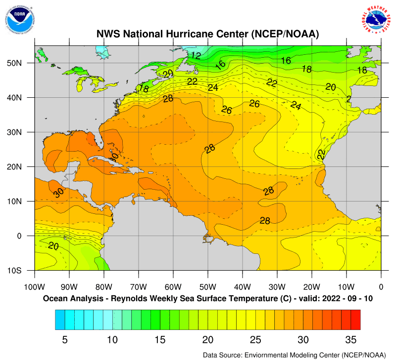
We have a wave north of the Greater Antilles (ex TD 10) that is getting better organized today and moving into a more favorable climate with extreme high SSTs and a ridge holding strong to the north...and its late August where climatologically it should develop

All I have to say is:

:eek:

Image

Image
Last edited by gatorcane on Wed Aug 24, 2005 9:47 am, edited 14 times in total.
0 likes   

WeatherEmperor
S2K Supporter
S2K Supporter
Posts: 4806
Age: 41
Joined: Thu Sep 04, 2003 2:54 pm
Location: South Florida

#2 Postby WeatherEmperor » Fri Aug 19, 2005 3:21 pm

Not yet. Once something becomes classified Ill start worrying. But it does need a close eye to be put on it though.

<RICKY>
0 likes   

jpigott
Category 2
Category 2
Posts: 692
Joined: Fri Sep 03, 2004 1:31 pm
Location: North Palm Beach, Florida

#3 Postby jpigott » Fri Aug 19, 2005 3:22 pm

not yet, but it sure is something to keep an eye on in the short term
0 likes   

DoctorHurricane2003

#4 Postby DoctorHurricane2003 » Fri Aug 19, 2005 3:22 pm

If I were you, I wouldn't expect a repeat of the 1935 FL Keys Hurricane. ;)

But it is really very dependent if the wave itself can gather more organization. Yes it is moving into a more favorable environment with high SSTs, but, if it can't organize itself, then there is nothing to worry about. Just watch it for now, but don't really expect anything major at the moment.
0 likes   

Patrick99
Category 5
Category 5
Posts: 1772
Joined: Mon May 24, 2004 3:43 pm
Location: SW Broward, FL

#5 Postby Patrick99 » Fri Aug 19, 2005 3:23 pm

I'm looking, but not nervous at all. I hope that whatever it is gives some rain....the only way I'd be nervous is by a sudden explosion to Cat. 3 strength.
0 likes   

User avatar
gatorcane
S2K Supporter
S2K Supporter
Posts: 23692
Age: 47
Joined: Sun Mar 13, 2005 3:54 pm
Location: Boca Raton, FL

#6 Postby gatorcane » Fri Aug 19, 2005 3:26 pm

there is a noticeable spin albeit at the mid levels (apparently) and this is the FIRST time convection is building on the W side showing the lessening shear....hmmm...
0 likes   

WeatherEmperor
S2K Supporter
S2K Supporter
Posts: 4806
Age: 41
Joined: Thu Sep 04, 2003 2:54 pm
Location: South Florida

#7 Postby WeatherEmperor » Fri Aug 19, 2005 3:29 pm

That is true boca-chris. If it reorganizes it will be slow nothing to rapid I dont expect. Just watch it. I know I will be cause of those near 90F waters just off our coast if you know what I mean....

<RICKY>
0 likes   

User avatar
HURAKAN
Professional-Met
Professional-Met
Posts: 46086
Age: 38
Joined: Thu May 20, 2004 4:34 pm
Location: Key West, FL
Contact:

#8 Postby HURAKAN » Fri Aug 19, 2005 3:30 pm

Waiting for rain, but not worried!
0 likes   

Scorpion

#9 Postby Scorpion » Fri Aug 19, 2005 3:30 pm

Not nervous at all nothing gonna happen til that big CV wave organizes.
0 likes   

User avatar
fci
S2K Supporter
S2K Supporter
Posts: 3324
Joined: Tue Sep 14, 2004 10:29 am
Location: Lake Worth, FL

#10 Postby fci » Fri Aug 19, 2005 3:30 pm

Chris:
The remnants of TD10 do not make me the least bit nervous.
I look forward to hopefully getting some rain and stirring of the air around here.

However, the SST's of 90 and prospect of a deficit in rain DO make me nervous. I remember last year with a dry summer and then BOOM; the tropics explode on us with hurricane force winds twice and 30" of rain.
(And I will not debate if we had Hurricane Force winds because from Central Palm Beach County north... WE DID)

So, TD10, who cares..
Others to come; VERY nervous.......
0 likes   

mascpa
S2K Supporter
S2K Supporter
Posts: 500
Age: 70
Joined: Tue Sep 30, 2003 10:43 am
Location: Jupiter, FL
Contact:

#11 Postby mascpa » Fri Aug 19, 2005 3:31 pm

After going thru both Frances and Jeanne last year, no, I'm not nervous. But I'll certainly pay attention. Is there any possibility of XTD 10 stalling and therefore having the time to really organize and strengthen?
0 likes   

User avatar
gatorcane
S2K Supporter
S2K Supporter
Posts: 23692
Age: 47
Joined: Sun Mar 13, 2005 3:54 pm
Location: Boca Raton, FL

#12 Postby gatorcane » Fri Aug 19, 2005 3:33 pm

but just because ex-TD 10 only has about 800 miles instead of 3000 miles of ocean in front of it doesn't mean it will not become a major hurricane....that is the point here.
0 likes   

User avatar
gatorcane
S2K Supporter
S2K Supporter
Posts: 23692
Age: 47
Joined: Sun Mar 13, 2005 3:54 pm
Location: Boca Raton, FL

#13 Postby gatorcane » Fri Aug 19, 2005 3:33 pm

I just got word that the Navy has begun showing interest in it again....
0 likes   

User avatar
Blown Away
S2K Supporter
S2K Supporter
Posts: 10161
Joined: Wed May 26, 2004 6:17 am

#14 Postby Blown Away » Fri Aug 19, 2005 3:33 pm

0 likes   

User avatar
gatorcane
S2K Supporter
S2K Supporter
Posts: 23692
Age: 47
Joined: Sun Mar 13, 2005 3:54 pm
Location: Boca Raton, FL

#15 Postby gatorcane » Fri Aug 19, 2005 3:34 pm

Blown_away hence my point...thanks
0 likes   

WeatherEmperor
S2K Supporter
S2K Supporter
Posts: 4806
Age: 41
Joined: Thu Sep 04, 2003 2:54 pm
Location: South Florida

#16 Postby WeatherEmperor » Fri Aug 19, 2005 3:35 pm

Blown_away wrote:No! But it can happen fast!

http://weather.unisys.com/hurricane/atl ... /track.gif


Lucky for us, none of us were alive when that hit south florida.

<RICKY>
0 likes   

NastyCat4

#17 Postby NastyCat4 » Fri Aug 19, 2005 3:53 pm

Take a Valium, and move to Colorado or New Mexico, dude. :roll:
0 likes   

Rainband

#18 Postby Rainband » Fri Aug 19, 2005 4:15 pm

NastyCat4 wrote:Take a Valium, and move to Colorado or New Mexico, dude. :roll:
Be nice. That was uncalled for.
0 likes   

Sanibel
Category 5
Category 5
Posts: 10375
Joined: Mon Aug 30, 2004 11:06 pm
Location: Offshore SW Florida

#19 Postby Sanibel » Fri Aug 19, 2005 4:22 pm

This system is showing a weak tendency. So any improvement to the west is probably going to be slow to evolve...
0 likes   

User avatar
EDR1222
S2K Supporter
S2K Supporter
Posts: 1253
Joined: Mon Nov 10, 2003 12:58 pm
Location: Melbourne, FL

#20 Postby EDR1222 » Fri Aug 19, 2005 4:31 pm

The NWS Melbourne afternoon discussion talks about the wave that was once TD-10. The thinking is, if that is organizes then it would likely turn north well before reaching the state as the models are indicating a breakdown in the ridge. It could be a rainmaker they say, if it stays weak. See Below:

FCST DILEMMA CONTINUES TO BE WHETHER OR NOT THE REMNANT
T-WAVE WHICH WAS T.D. 10 WILL PUSH CLOSE ENOUGH TO ECFL TO HAVE ANY
SIGNIF EFFECT ON WX. SYNOPTIC PATTERN/MODEL GUIDANCE CONTINUE TO
INDICATE THAT A WEAKER SYSTEM (I.E. OPEN WAVE) WOULD HAVE A BETTER
CHANCE OF SNEAKING UNDERNEATH THE MID LEVEL WEAKENESS AROUND 75-80W
(JUST EAST OF THE STATE) RESULTING IN HIGHER RAIN CHCS. REGNERATION
INTO A T.C. WOULD PORTEND A MORE NORTHWARD TURN AS IT MOVES INTO THE
BAHAMAS...PSBLY DRAGGING IN SOME RELATIVELY DRIER AIR TO IT'S WEST
AS IT DOES
0 likes   


Return to “Talkin' Tropics”

Who is online

Users browsing this forum: Bobbyh83, Jonny, kenayers, Kludge, riapal and 38 guests