Highest storm surge in US history

This is the general tropical discussion area. Anyone can take their shot at predicting a storms path.

Moderator: S2k Moderators

Forum rules

The posts in this forum are NOT official forecasts and should not be used as such. They are just the opinion of the poster and may or may not be backed by sound meteorological data. They are NOT endorsed by any professional institution or STORM2K. For official information, please refer to products from the National Hurricane Center and National Weather Service.

Help Support Storm2K
Message
Author
User avatar
wxman57
Moderator-Pro Met
Moderator-Pro Met
Posts: 22480
Age: 66
Joined: Sat Jun 21, 2003 8:06 pm
Location: Houston, TX (southwest)

#21 Postby wxman57 » Sat May 06, 2006 12:52 pm

Audrey2Katrina wrote:That's an interesting graphic, and it certainly lends credence to just what the surge of the infamous "Last Island" hurricane of 1856 might have been (Being in the Vermillion Bay area). This is estimated to have been a Cat 4 storm, and while no verifiable data is available on the surge that turned a barrier island resort complete with multiple-storey hotels and gambling casinos into a rent-into-pieces sandbar had to have been at least in the 15-20 ft. range IMO. This would also correlate to your graph well.

And while I agree with most of what you posted, including the Betsy comment, (I remember her well), I can't say I quite understand your comments about Carla. Perhaps that is because I'm not fully comprehending what you mean by "destructive" as there have been many storms that have far outstripped Carla in "destruction" as measured by either death toll, or damage figures. I DO remember when she hit Texas, as a child I watched with childlike thrill the televised reports; (not to mention never missing a report by our own local favorite: Nash Roberts, pulling out all his charts to graph its every movement) but I have no ready info on her wind field or radii of hurricane force winds. I DO know that NOAA reports have Katrina having a hurricane wind radius, at one point, of something akin to 120nm, and that's no slouch, as well as a NHC report citing it as one of the "largest" hurricanes in Atlantic Basin history. Verified hurricane winds from the western panhandle of Florida all the way to well into SE La. pretty much verify a swath some 200 miles across, again, hardly a small area of hurricane winds. I'm also dubious about the comment that hurricanes like Katrina and Rita are not that uncommon in the NW Gulf... both of these were strong Cat 5's and I just don't find that many Cat 5's in the NGOM at all, making them quite uncommon; but perhaps my research is lacking there--just don't know and perhaps that's just another differing way of looking at the semantics of "common".

All that aside, could you put that chart with the estimated Cat 4 strength of the Last Isle storm to come up with an estimated surge there? I believe most maps today refer to the remnant sandbars as Isles Derniere. Reading about this storm as a child (shortly after Audrey) began my fascination with these monster events, and I still say there's an awful lot about this one we don't have information on. Call it an insatiable curiosity with the storm that only left one terrified cow alive on an Island that previously had housed hundreds of revellers the night of Aug. 10, 1856.

A2K


Damage totals and lives lost are a function more of where a hurricane hits, not its true destructive potential. Yes, there are many hurricanes which killed more people or caused a greater loss dollar-wise, but Carla was quite possibly the most powerful very large hurricane to ever hit the U.S. Of course, accurate wind field records don't exist for many storms prior to even 1988. Take a look at the size of Carla's 100 mph wind field in comparison to quite large hurricanes like Ivan, Katrina, and Rita:

http://myweb.cableone.net/nolasue/100mph.gif

Carla was a Cat 5 just off the mid Texas coast just before landfall. It weakened to a Cat 4 at landfall. Note that the 100 mph wind field was nearly twice that of Ivan or Katrina. Carla was huge and its RMW (Radius of Max Winds) was just about the greatest of any hurricane to hit the U.S. Had Carla hit where Katrina did, the storm surge would have been significantly larger and the wind damage tremendously greater. Not many of those in east New Orleans who were rescued in the week after Katrina would have survived.
0 likes   

User avatar
Audrey2Katrina
Category 5
Category 5
Posts: 4236
Age: 74
Joined: Fri Dec 23, 2005 10:39 pm
Location: Metaire, La.

#22 Postby Audrey2Katrina » Sat May 06, 2006 1:35 pm

Stratosphere747 wrote:I'll assume that 57 meant the destructive coverage of Carla. I've had an interesting debate on another forum about how big Carla really was. There are varying reports from knowledgeable mets that Carla's cloud coverage literally engulfed upwards of two-thirds of the GOM. Just visualizing, she would dwarf both Katrina and Rita.

Sustained winds ranging from 115 in Matagorda to 90 in Galveston, and grant you this is Texas, that is one heck of wind field of sustained winds, along with SS values from 18ft in the Corpus Christi area to 10 to 12ft from Galveston to Tx/La border. As far as SS coverage, she might just have had the largest range of any hurricane.

Wish we had a decent sat image of Carla.


So do I, because one can only go with speculation (which invites healthy debate :wink: without it); but the distance from Matagorda to Galveston, while healthy indeed, is not nearly 200 miles. Without those much bewailed sat images the "size" issue can never be resolved; however both NASA and NOAA imagery shows both Rita and Katrina as rather large storms, and one shot of Katrina, taken long before her maximum widening of wind/cloud field shows bands enwrapping her from the west coast of Florida, brushing along the entire NGOM, and extending down to the Yucatan of Mexico, which I would presume represents more than a sizeable chunk of the Gulf, hence the idea of any storm "dwarfing" that size seems unimaginable (IN the GOM). Regardless... she (Carla) was an incredible storm, and by every account I've seen recently, the "benchmark" of storm sizes for the Texas area. (--at least for the last century--who even remotely knows how big the Galveston storm was?)

A2K
0 likes   

Derek Ortt

#23 Postby Derek Ortt » Sat May 06, 2006 1:41 pm

maybe wxman57 can correct me on this,

but if one takes an index of the size and intensity, I believe he told me at the ams conference that Carla was the most powerful hurricane ever to his the USA
0 likes   

MiamiensisWx

#24 Postby MiamiensisWx » Sat May 06, 2006 1:45 pm

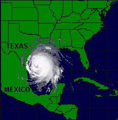
I just found this REALLY neat graphic that shows just how large Carla may have been to scale... this is actuallyt quite realistic!

Image

Here is the source of this graphic. What do you think?
0 likes   

User avatar
wxman57
Moderator-Pro Met
Moderator-Pro Met
Posts: 22480
Age: 66
Joined: Sat Jun 21, 2003 8:06 pm
Location: Houston, TX (southwest)

#25 Postby wxman57 » Sat May 06, 2006 1:48 pm

Derek Ortt wrote:maybe wxman57 can correct me on this,

but if one takes an index of the size and intensity, I believe he told me at the ams conference that Carla was the most powerful hurricane ever to his the USA


That would be correct, Derek. The only caveat I'd add is that wind radii data from pre-1988 hurricanes is sparse at best. I believe that Carla's wind field size was near the top of all hurricanes from 1988 to 2005 (if not the biggest).
0 likes   

User avatar
Audrey2Katrina
Category 5
Category 5
Posts: 4236
Age: 74
Joined: Fri Dec 23, 2005 10:39 pm
Location: Metaire, La.

#26 Postby Audrey2Katrina » Sat May 06, 2006 2:04 pm

Carla was a Cat 5 just off the mid Texas coast just before landfall. It weakened to a Cat 4 at landfall. Note that the 100 mph wind field was nearly twice that of Ivan or Katrina. Carla was huge and its RMW (Radius of Max Winds) was just about the greatest of any hurricane to hit the U.S. Had Carla hit where Katrina did, the storm surge would have been significantly larger and the wind damage tremendously greater. Not many of those in east New Orleans who were rescued in the week after Katrina would have survived


I can't and won't dispute many of your hypotheses in the above post; however I will comment that by your own admission data even as recently as 1988 is not available in sufficient amounts to come to any certifiably 100% claim of accuracy. How much less one going back to 1961? The chart you offer is a very interesting one; albeit subject to those same limitations. It is also a representation of what is based on 100 mph sustained, and without regard to any margin of error, accuracy of available data sources, or subjectivity, the radius of "hurricane" force winds is not shown, and by every account I've seen, Katrina's would have been larger--don't know enough about Rita, but she was also a pretty large storm.

On the other hand, I had pretty much figured that your assessment of "most destructive" was, in all likelihood, based on "potential" rather than actual damage. But one must remember that when one engages in speculation of this sort, the resultant pandora's box of other "possibilities" is opened. What if the property values of Florida were as low as those of Mississippi and Louisiana's? Where would Andrew have finished in the dollar damage? Contrariwise assume that La. and Miss had property values equivalent to those of So. Fla--the figures on Katrina would be more than staggering. What if the Galveson storm had struck NYC with the same intensity in 1900? It's fascinating to speculate; but it's only the realities that are beyond dispute. Personally, I consider the Galveston storm the worst to have ever struck by virtue of human toll. In dollar damage, it was Katrina by a wide margin and by intensity it was the Labor Day Hurricane of 1935. I guess that what I'm getting at is one can restrict, or unleash enough data to make any catastrophic storm a superlative in one way or another. Suffice it to say your opinions are respected (and obviously well thought out); but universal agreement is the one thing mankind will never agree on. :wink:

A2K
0 likes   

User avatar
wxman57
Moderator-Pro Met
Moderator-Pro Met
Posts: 22480
Age: 66
Joined: Sat Jun 21, 2003 8:06 pm
Location: Houston, TX (southwest)

#27 Postby wxman57 » Sat May 06, 2006 2:12 pm

It is true that there isn't much reliable data for storms prior to the modern reconnaissance age. There was recon inside Carla, however, and we do have some data. Prior to the 50s, though, there is no good wind data at all.

I have a few graphics to demonstrate the size of Carla in comparison to Katrina. Perhaps you missed this graphic of NW Gulf hurricane-force winds:

http://myweb.cableone.net/nolasue/nwgulfmajors.gif

According to the data we have on Carla, its hurricane-force wind radii were considerably larger than Katrina, Rita, or Ivan (at their peaks well offshore).

Here are a few snapshots of Carla and one of Betsy from an animated .rex file in the SLOSH program:

http://myweb.cableone.net/nolasue/carla.gif


Carla at its peak. Note the red hurricane-force winds reach from near Brownsville to Galveston. That's over 200 miles across.
http://myweb.cableone.net/nolasue/carla2.gif

http://myweb.cableone.net/nolasue/betsy.gif (At its peak)

Note that the shot of Betsy is zoomed in quite a bit more than for Carla. Carla was much larger than Betsy.
Last edited by wxman57 on Sat May 06, 2006 2:14 pm, edited 1 time in total.
0 likes   

User avatar
Audrey2Katrina
Category 5
Category 5
Posts: 4236
Age: 74
Joined: Fri Dec 23, 2005 10:39 pm
Location: Metaire, La.

#28 Postby Audrey2Katrina » Sat May 06, 2006 2:14 pm

Derek Ortt wrote:maybe wxman57 can correct me on this,

but if one takes an index of the size and intensity, I believe he told me at the ams conference that Carla was the most powerful hurricane ever to his the USA


Indeed, and that is exactly what is being discussed. What is the measure of "intensity"? Is it pressure? I know Katrina reached 902, and don't know Carla's (though I'm sure it was pretty low). As far as size... again, we do not have the sat imagery to come to a bona-fide conclusion there; albeit that having been said, I fully respect Wxman's professional opinion.

Now... trying to get back to the thread (which seems to have gone astray), what were the surge data on Carla? and it might be interesting if someone were to revise that original list given all the susequent comments... right now, I'm taking a break. 8-)

A2K
0 likes   

User avatar
wxman57
Moderator-Pro Met
Moderator-Pro Met
Posts: 22480
Age: 66
Joined: Sat Jun 21, 2003 8:06 pm
Location: Houston, TX (southwest)

#29 Postby wxman57 » Sat May 06, 2006 2:18 pm

I don't think that pressure is a reliable indicator of wind strength. A hurricane with the same central pressure could have max winds spanning 2 or 3 SS categories. It's pressure gradient that determines wind speed. Given 2 hurricanes with the same central pressure, the hurricane with the larger wind field will have the lesser pressure gradient and thus the lower winds. That's why Katrina's winds were not as high as some thought the central pressure would indicate. The greater the distance between the core and the radius of max winds, the lower the pressure gradient and the lower the peak winds.
0 likes   

User avatar
wxman57
Moderator-Pro Met
Moderator-Pro Met
Posts: 22480
Age: 66
Joined: Sat Jun 21, 2003 8:06 pm
Location: Houston, TX (southwest)

#30 Postby wxman57 » Sat May 06, 2006 2:29 pm

Audrey2Katrina wrote:Now... trying to get back to the thread (which seems to have gone astray), what were the surge data on Carla? and it might be interesting if someone were to revise that original list given all the susequent comments... right now, I'm taking a break. 8-)

A2K


Actually, I don't think that the thread has gone astray. Hurricane size is one of the main components of storm surge. In any case, also consider from the shoaling factor diagram I posted that the surge multiplier for where Carla hit was only about 0.7 as compared to 1.75 for where Katrina hit. So a hurricane that would normally produce a 15 ft surge hitting Bay St. Louis would produce a surge of 25-26 feet (Katrina). That same hurricane hitting where Carla hit would produce a surge of only about 10-11 feet. Size (particularly Radius of Maximum Winds) definitely matters with hurricanes and storm surge.

As for Carla's storm surge, I'm seeing reports of from 18-22 feet. Remember that Katrina, hitting where Carla did, would produce a surge of 10-11 feet. Using the shoaling factor of 0.7 for Carla's landfall and Camille's landfall (1.75), then a hurricane producing an 18 ft storm surge on the mid TX coast might produce a 45 foot storm surge on the SW MS Coast. Consider that, those of you in Mississippi.

By the way, if you want to learn more about how to manually calculate storm surge you can pick up a copy of the Shore Protection Manual. It's not cheap ($75):

http://www.amazon.com/gp/product/089499 ... e&n=283155

The updated version is called the Coastal Engineering Manual:
http://www.veritechinc.net/products/cem/index.htm
0 likes   

User avatar
milankovitch
Tropical Storm
Tropical Storm
Posts: 243
Age: 39
Joined: Fri Sep 17, 2004 11:30 pm
Location: Menands, NY; SUNY Albany
Contact:

#31 Postby milankovitch » Sat May 06, 2006 3:27 pm

Does anyone know where I can get a copy of slosh. Is this online somewhere or do you have to get it on a cd?
0 likes   

User avatar
wxman57
Moderator-Pro Met
Moderator-Pro Met
Posts: 22480
Age: 66
Joined: Sat Jun 21, 2003 8:06 pm
Location: Houston, TX (southwest)

#32 Postby wxman57 » Sat May 06, 2006 3:31 pm

milankovitch wrote:Does anyone know where I can get a copy of slosh. Is this online somewhere or do you have to get it on a cd?


I got my copy at the local NWS hurricane conference (in Houston) a few years ago. They were instructing a class in its use and passing out CDs. You might ask your local NWS office if they have copies.
0 likes   

User avatar
Audrey2Katrina
Category 5
Category 5
Posts: 4236
Age: 74
Joined: Fri Dec 23, 2005 10:39 pm
Location: Metaire, La.

#33 Postby Audrey2Katrina » Sat May 06, 2006 3:36 pm

CapeVerdeWave wrote:I just found this REALLY neat graphic that shows just how large Carla may have been to scale... this is actuallyt quite realistic!

Image

Here is the source of this graphic. What do you think?


Well that's an interesting graphic; but I think this image I found while searching for radar images presents a more realistic (inasmuch as it IS a radar image) of the storm's scope.

Image

Now I can't say anything for certain as it's anything but one of those suped-up modern models with everything superimposed; but it IS from the Galveston radar, and I dunno... maybe it's just me; but I don't see it as being anywhere near the "size" shown in that image. That said, I will say she's one tight looking storm, (extremely symmetrical around the eye!) and quite impressive by any standard.

A2K
0 likes   

User avatar
Audrey2Katrina
Category 5
Category 5
Posts: 4236
Age: 74
Joined: Fri Dec 23, 2005 10:39 pm
Location: Metaire, La.

#34 Postby Audrey2Katrina » Sat May 06, 2006 3:49 pm

wxman57 wrote:I don't think that pressure is a reliable indicator of wind strength. A hurricane with the same central pressure could have max winds spanning 2 or 3 SS categories. It's pressure gradient that determines wind speed. Given 2 hurricanes with the same central pressure, the hurricane with the larger wind field will have the lesser pressure gradient and thus the lower winds. That's why Katrina's winds were not as high as some thought the central pressure would indicate. The greater the distance between the core and the radius of max winds, the lower the pressure gradient and the lower the peak winds.


Essentially I agree, and I THINK I understand the point you're making; but doesn't that equally apply to the "size" of Carla as it would the size of Katrina? IF Carla were as massive in size as some are claiming (and I really can't say one-way or the other) then surely the vastness of her size and wind field (as per your own chart) would lower her pressure gradient and hence peak winds substantially as well. Additionally her minimum central pressure was nearly 30 mb higher than that of Katrina. (finally looked it up: 931 mb--correct me if that's inaccurate).

Finally I really don't disagree at all about pressure gradient and/or wind speeds, but there are a lot of other complexities to be considered in determining exatly where the isobars would be and at what distance from the COC in determining that gradient. What I was asking was that if one used "size and intensity" as a means of determining the most "destructive" of storms, well, we've already gone over the size thingy and at best I feel the jury's still out, but wanted to know what was the criterion for measuring intensity. I'm not trying to be sarcastic as this is your field, not mine, but I figured "intensity" was determined by lowest central pressure... I sincerely ask: are you suggesting a better means of determining intensity would be to look at pressure gradient "instead" of simply looking at lowest CP?

A2K
0 likes   

User avatar
Audrey2Katrina
Category 5
Category 5
Posts: 4236
Age: 74
Joined: Fri Dec 23, 2005 10:39 pm
Location: Metaire, La.

#35 Postby Audrey2Katrina » Sat May 06, 2006 3:53 pm

BTW, thanks for all those images... especially the one of Betsy--very impressive. I'm sure I don't have to tell YOU this; but I was kind of taken back upon discovering that in the same 1961 season that gave us Carla, there was a Category 4 "fish" that preceded it by the name of: Betsy. :D

Also thanks for the links to the Shore Protection Manual info... I just might look into that. Needless to say all these recent events, not to mention the terrain upon which I live, have made this a much more interesting facet of all this storm/hurricane verbiage.

A2K
0 likes   
Flossy 56, Audrey 57, Hilda 64*, Betsy 65*, Camille 69*, Edith 71, Carmen 74, Bob 79, Danny, 85, Elena 85, Juan 85, Florence 88, Andrew 92*, Opal 95, Danny 97, Georges 98*, Isidore 02, Lili 02, Ivan 04, Cindy 05*, Dennis 05, Katrina 05*, Gustav 08*, Isaac 12*, Nate 17, Barry 19, Cristobal 20, Marco, 20, Sally, 20, Zeta 20*, Claudette 21 IDA* 21

Stratosphere747
Category 5
Category 5
Posts: 3772
Joined: Thu Sep 11, 2003 8:34 pm
Location: Surfside Beach/Freeport Tx
Contact:

#36 Postby Stratosphere747 » Sat May 06, 2006 3:55 pm

http://history.nasa.gov/SP-168/section1.htm

Go down a few clicks and you will see the first sat images of hurricanes.

This is one of the few images of Carla, and I use that term loosely as it is hard to gauge, though much better than the radar..

I've asked a few people with more knowledge than myself and they agree this is a good representation of Carla and the size she was in the GOM.

The Florida peninsula is supposed to be on the right, with the Yucatan directly under the marker.


With respect to SS, its obvious that the last few years have taught us quite a bit, and in relation to the actual size of the storm even more with regards to the correlation of pressure and wind field.
0 likes   

User avatar
Audrey2Katrina
Category 5
Category 5
Posts: 4236
Age: 74
Joined: Fri Dec 23, 2005 10:39 pm
Location: Metaire, La.

#37 Postby Audrey2Katrina » Sat May 06, 2006 4:16 pm

Stratosphere747 wrote:http://history.nasa.gov/SP-168/section1.htm

Go down a few clicks and you will see the first sat images of hurricanes.

This is one of the few images of Carla, and I use that term loosely as it is hard to gauge, though much better than the radar..

I've asked a few people with more knowledge than myself and they agree this is a good representation of Carla and the size she was in the GOM.

The Florida peninsula is supposed to be on the right, with the Yucatan directly under the marker.


With respect to SS, its obvious that the last few years have taught us quite a bit, and in relation to the actual size of the storm even more with regards to the correlation of pressure and wind field.


Those are TIROS satellite images, and for their time, they were state of the art; however, not knowing the zoom, or angle of the surface they cover, (or any other number of relevant variables that could potentially further distort a true image) I respectfully disagree that it is a much better view of the storm than provided by the radar.(and being spoiled by modern technology the resolution leaves much to be desired.) Perhaps it is a better view of cloud cover, as it is quite possible a lot of those aren't in the radar image, I dunno and readily admit it. However, while I'll not dispute the obvious expanse of cloud cover, without a good view of it from directly above, wherein one can truly see the visible shorelines surrounding the Gulf it is difficult to determine. I, too, have friends who are very much into meteorology and recall Carla vividly. They feel that she and Katrina were comparable in size (remember the modern sat images of Katrina show bands encircling the entire region from Florida to the Texas line, and from the NGOM down to the Yucatan as well... it's not really possible (without time travel) to ascertain beyond reasonable doubt the full size of Carla. One thing I feel confident in saying however, is she neither "dwarfs" Katrina, nor Rita. Suffice it to say I'm convinced it was at the very least one of the largest to enter the Gulf. Whether or not she actually was will almost certainly never be resolved.

A2K
0 likes   

User avatar
wxman57
Moderator-Pro Met
Moderator-Pro Met
Posts: 22480
Age: 66
Joined: Sat Jun 21, 2003 8:06 pm
Location: Houston, TX (southwest)

#38 Postby wxman57 » Sat May 06, 2006 6:17 pm

Audrey2Katrina wrote:Well that's an interesting graphic; but I think this image I found while searching for radar images presents a more realistic (inasmuch as it IS a radar image) of the storm's scope.

Image

Now I can't say anything for certain as it's anything but one of those suped-up modern models with everything superimposed; but it IS from the Galveston radar, and I dunno... maybe it's just me; but I don't see it as being anywhere near the "size" shown in that image. That said, I will say she's one tight looking storm, (extremely symmetrical around the eye!) and quite impressive by any standard.

A2K


That radar can be a bit deceiving. Carla passed about 170 miles south of Galveston. That radar picture was taken when the center was about 180 miles from Galveston's radar (26.5N/94.5W). Because of attenuation and the surface of the earth curving away from the radar beam, you're seeing only half the hurricane. Looks like TS force winds have already moved ashore north of Galveston at 180 miiles from the center. That's a monster of a hurricane.
0 likes   

User avatar
MGC
S2K Supporter
S2K Supporter
Posts: 5792
Joined: Sun Mar 23, 2003 9:05 pm
Location: Pass Christian MS, or what is left.

#39 Postby MGC » Sat May 06, 2006 6:17 pm

I remember watching TV news when Carla was in the GOM. Nash Roberts, the TV met on the air back in the 60's said the clouds over New Orleans were the cirrus outflow from Carla. So, considering that Carla passed like 300NM south of New Orleans I can only imagine that Carla's circulation nearly covered the entire central to western GOM.......MGC
0 likes   

User avatar
wxman57
Moderator-Pro Met
Moderator-Pro Met
Posts: 22480
Age: 66
Joined: Sat Jun 21, 2003 8:06 pm
Location: Houston, TX (southwest)

#40 Postby wxman57 » Sat May 06, 2006 6:20 pm

One more thing about Carla's pressure A2K. Yes the lowest measured pressure was 931mb. But there wasn't a continuous stream of recon into Carla as there would be with current storms. I'm not sure how often Carla's pressure was actually measured. Could well have been 15-25 mb lower. But, again, it's the size of the stronger wind field that is more significant than the peak wind in a tiny area near the core.
0 likes   


Return to “Talkin' Tropics”

Who is online

Users browsing this forum: cycloneye, Flakeys, Hurricane2022, Hurricaneman, Michele B, Tak5, TheAustinMan and 174 guests