I have posted a similar picture-based saffir simpson scale MANY times on storm2k in the past, but I felt I should do it again in it's very own thread before we reach the beginning of the 2006 (Now 2007) season. This picture/video based scale will give those who have escaped the wrath of a hurricane over the last many years a better picture of what to expect during the storm and after the winds subside. If you do not need to worry about storm surge, this is also a good idea of what you will see if you stay during the storm:
TROPICAL DEPRESSION
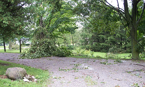
A tropical depression is a spinning tropical cyclone that has winds of under 39mph sustained (not yet a tropical storm). It usually causes little to no damage, but in some instances they have produced tornadoes and flooding rains. No evacuations should be issued during a depression and there is typically little worry of damage (even right along the coast).
http://www.youtube.com/watch?v=zeH6p8BFlIc
http://www.youtube.com/watch?v=FaSOCcIiorM
http://www.youtube.com/watch?v=NIwX8OghYtM
http://www.youtube.com/watch?v=gqbf3bNBgqQ
^^A few examples of what you would typically expect from a tropical depression^^
Typical damage: http://www.brianbehrend.com/archives/im ... Damage.jpg
WEAK TROPICAL STORM
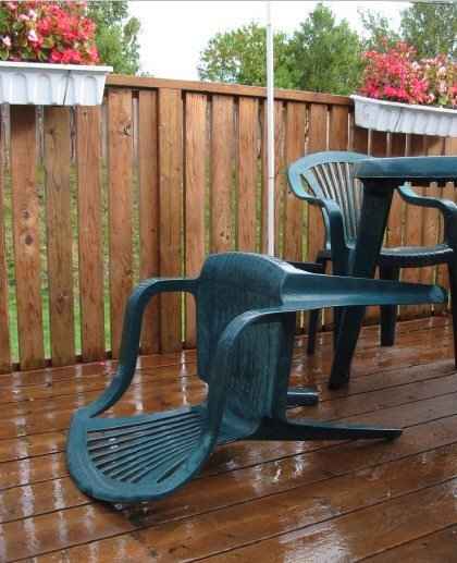
A weak tropical storm is a tropical storm with winds of 39-57mph sustained and top gusts of less than 74mph. These storms can do some minor damage, but structural damage is isolated and rare. The biggest threat is inland flooding.
http://www.youtube.com/watch?v=pCmdCHs8Yag
^^This is an idea of what 35-40mph sustained winds and gusts to 50-60mph is like^^
http://www.mackandtim.net/video/jeanne/MOV02225.MPG
^^This is a good video idea of what 40-50mph sustained winds and gusts to 60-70mph looks like^^
http://www.youtube.com/watch?v=ii_TMCYq37s
^^Another good video of what true weak TS force conditions would look like (probably on the lower end though..30-40mph sustained..gusts to 35-50mph)^^
http://66.70.209.226/weather/091002/DSC00015.JPG
http://www.apeshot.com/rita/hor/rita-friday-021.jpg
http://www.redcross.org/news/ds/hurrica ... 6_sign.JPG
http://farm1.static.flickr.com/87/20870 ... 20.jpg?v=0
http://l.yimg.com/www.flickr.com/images/spaceball.gif
^^typical damage^^
STRONG TROPICAL STORM
Strong tropical storm conditions consist of 58-73mph sustained winds and gusts as high as 80-95mph. These type of winds can do significant tree and sign damage, but serious structural damage is usually isolated. These conditions are usually only experienced right along the coast during a strong tropical storm landfall or within the inner bands of a landfalling or inland hurricane.
http://www.suncam.tv/images/Archeves-Hu ... Jeanne.wmv
^^This video shows what is probably 60-70mph sustained winds and gusts to 80-90mph.^^
http://www.weatherbook.com/images/isabel/dc7_web.jpg
http://66.175.38.157/damage%208.jpg
http://www.srh.noaa.gov/bro/spi13.jpg
http://www.greatdreams.com/weather/ophe ... amage..jpg
http://www.k5kj.net/point7.JPG
http://farm1.static.flickr.com/1/819586 ... ad.jpg?v=0
^^typical damage^^
CAT. 1 HURRICANE
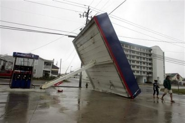
Category one hurricane conditions are the most common type of experience for those who have gone through "hurricane force winds". Winds within Cat. 1 conditions are sustained at 74-95mph and can gust up to 100-115mph. These type of winds can do heavy tree and sign damage, and structural damage is possible to roofs, garage doors, pool screens and windows. These type of conditions are seen/felt at the immediate coast during a Cat. 1 landfall or up to 100+ miles inland during a strong hurricane landfall. You usually need to be within 50 miles of the eyewall (during a strong hurricane) or within the eyewall (during a weak hurricane) to experience these type of conditions.
http://www.stormvideo.com/05/katrinasouthflorida.wmv
^^video of strong TS/Cat. 1 conditions^^
http://video.google.com/videoplay?docid ... =hurricane
^^Cat. 1 winds in New Orleans from Katrina.^^
http://www.oe.netl.doe.gov/docs/charley ... irport.jpg
http://www.nbbd.com/Beacon/archives/040 ... nterRd.jpg
http://www.srh.noaa.gov/jan/katrina/Ima ... G_0011.jpg
http://farm1.static.flickr.com/17/22882 ... af.jpg?v=0
http://www.srh.noaa.gov/jan/katrina/Ima ... G_0006.jpg
http://hurricanearchive.org/content/thu ... _thumb.JPG
http://www.bjornstrom.se/pics/156.jpg
http://www.srh.noaa.gov/ffc/images/ftben111506a.jpg
http://img325.imageshack.us/img325/9007/storm2k45fn.jpg
http://www.icyclone.com/images/stories/ ... y/3528.jpg
^^typical Cat. 1 damage^^
CAT. 2 HURRICANE
Category two hurricane conditions are very extreme and usually only felt right at the coast during a Cat. 2/3 landfall or inland during a Cat. 3-5 force landfall. These winds can cause widespread damage to trees, signs and structures. Winds range from 96-110mph sustained and gusts can hit as high as 131mph.
http://www.youtube.com/watch?v=-JuQDsDJZ-I
^^The winds in this video likely peak in the low-end Category 2 range^^
http://video.google.com/videoplay?docid ... =hurricane
^^This one will send chills down your spine.^^
http://ekle.us/media/08-30-05_1104.jpg
http://www.southfloridaroofing.com/hurr ... amage3.jpg
http://www.galtmile.com/images/condoverobch.jpg
http://www.mgccc.edu/InTouch/October200 ... mage-3.jpg
http://www.crh.noaa.gov/arx/events/images/roof.jpg
http://www.orlandosentinel.com/media/ph ... 824038.jpg
^^typical Cat. 2 damage^^
CAT. 3 HURRICANE
Few people experience major hurricane conditions unless right along the coast during a Cat. 3/4 landfall or inland during a Cat. 4/5 landfall. Winds are sustained at 111-130mph and gusts can reach up to 156mph. Widespread major damage usually results.
http://www.psphoto.com/upload/katrina_webclip.wmv
^^probable Cat. 3 conditions during peak of video^^
http://www.youtube.com/watch?v=9Lhj2QUFIyQ
^^These are likely pretty solid Cat. 3 force winds (may be a possible peak into Cat. 4 during the height of the video)^^
http://studo.umkc.edu/globemed/DSC00111.JPG
http://www.sbcmag.info/past/2004/04nov/ ... ane-13.jpg
http://soundwaves.usgs.gov/2005/03/watertowerLG.jpg
http://www.glennbeck.com/news/09-09-04/8.jpg
http://www.srh.noaa.gov/mlb/surveys/022 ... house1.jpg
http://davidmichaelkennedy.com/blog/med ... cane-1.jpg
http://www.fas.org/irp/imint/docs/rst/S ... ome-ap.jpg
^^typical Cat. 3 damage^^
CAT. 4 HURRICANE
Category four conditions are extremely dangerous and very rare. Winds reach 131-155mph sustained and gust to 175mph. These type of conditions are only experienced right along the coast during a Cat. 4/5 landfall or slightly inland during a Cat. 5 landfall. These winds cause widespread extensive damage.
http://www.youtube.com/watch?v=LvPdQPnSstY
^^Probable borderline Cat. 3/4 conditions^^
http://www.suncam.tv/images/Archeves-Hu ... rley-1.wmv
^^More Cat. 3/4 conditions from Hurricane Charley. Lots of debris!^^
http://www.youtube.com/watch?v=vZHi5LL3U2Y
^^Typhoon Pongsona in Guam produces Cat. 3/4 force winds during the height of this video.^^
http://www.dw-world.de/image/0,,1298489_1,00.jpg
http://www.thermogardsolarfilms.com/charley_video16.jpg
http://www.floridatoday.com/galleries/n ... ath/13.jpg
http://www.apwa.net/Images/Publications ... ilson1.JPG
http://www.srh.weather.gov/srh/jetstrea ... damage.jpg
http://nola.live.advance.net/washingawa ... rooves.jpg
http://www.abc.net.au/reslib/200408/r27408_67983.jpg
http://www.parrinspections.com/graphics ... _Erwin.jpg
^^Typical Cat. 4 damage^^
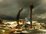
CAT. 5 HURRICANE
Category five conditions are extremely rare and have only been felt in the United states three times. These type of winds are also usually restricted to the immediate coast when they do occur, unless they are unusually strong (175mph+), in which case they may be carried inland a few miles. Wind speeds top 156mph sustained and gusts can reach 225mph!
I could not find any confirmed Cat. 5 video.
Cat. 5 pictures may be found by googling Hurricane Andrew or Hurricane Camille, but even then...most of the damage you will find falls in the Cat. 3-4 range.
The following pictures are probably the closest to what you can expect from a Category 5 force wind..
http://upload.wikimedia.org/wikipedia/c ... andrew.jpg
http://kids.earth.nasa.gov/archive/hurr ... andrew.GIF
http://www.greenpeace.org/raw/image_ful ... andrew.jpg
**Remember that these pictures and videos are only close representations of what you can expect, and are not always 100% accurate.**
This was last updated June 2nd, 2007
Hurricane Damage
Moderator: S2k Moderators
Forum rules

The posts in this forum are NOT official forecasts and should not be used as such. They are just the opinion of the poster and may or may not be backed by sound meteorological data. They are NOT endorsed by any professional institution or STORM2K. For official information, please refer to products from the National Hurricane Center and National Weather Service.
-
Extremeweatherguy

- Category 5

- Posts: 11095
- Joined: Mon Oct 10, 2005 8:13 pm
- Location: Houston, TX
Hurricane Damage
Last edited by Extremeweatherguy on Sat Jun 02, 2007 3:48 pm, edited 22 times in total.
0 likes
-
bombarderoazul
- Tropical Storm

- Posts: 186
- Joined: Tue Sep 20, 2005 4:12 pm
-
wxman57

- Moderator-Pro Met

- Posts: 22480
- Age: 66
- Joined: Sat Jun 21, 2003 8:06 pm
- Location: Houston, TX (southwest)
Good collection of videos. But I believe that the video of "Cat 1" conditions from Katrina in S. FL is actually moderate TS force winds. Katrina's hurricane force winds stayed off the coast of Florida. As for the "Cat 2" winds in Wilma, that's probably Cat 1 winds for the most part. There could have been a few small areas of Cat 2 sustained wind with Wilma's passage, but I didn't see what looked like Cat 2 in that video. All the Charley videos I've seen look like Cat 3 winds, though it may be hard to distinguish Cat 3 from Cat 4.
0 likes
-
Derek Ortt
-
Extremeweatherguy
- Category 5
- Posts: 11095
- Joined: Mon Oct 10, 2005 8:13 pm
- Location: Houston, TX
It was hard to tell with the Katrina and Wilma video in Miami, because in the Katrina video..the chaser says, "this is definitely a hurricane now". Plus, the palm trees and sand makes it look stronger. Also, as for Wilma, I found it hard to find a video that was for sure Cat. 2 conditions, so I decided to just go with the video of Miami seeing "near Cat. 2" conditions, as it was the closest thing I could find. I think the videos are close enough to keep for now, but I will continue looking to see if I can find better videos to replace them with in the future. These videos do go to show, however, that even strong TS/Cat. 1 conditions are bad, and I hope that is what everyone who has been spared in recent years can take from this for this season.
0 likes
-
Extremeweatherguy
- Category 5
- Posts: 11095
- Joined: Mon Oct 10, 2005 8:13 pm
- Location: Houston, TX
-
Scorpion
-
Derek Ortt

-
Opal storm
http://www.professionalroofing.net/phot ... bex_23.jpg
I don't see cat 3 damage in this pic.Notice how there's a street sign by the road still standing,the powerlines are still up and the telephone poles are perfectly up-right.Yes those roofs are severly torn up but we had roofs look like that here in Pensacola with Ivan and most of the area had sustained cat 1 winds.Also, by the look of it those buildings were probably very exposed to the wind.This is just my opinion though.Other than that it's a great scale and I will look back at this later in the season if a storm heads my way.
I don't see cat 3 damage in this pic.Notice how there's a street sign by the road still standing,the powerlines are still up and the telephone poles are perfectly up-right.Yes those roofs are severly torn up but we had roofs look like that here in Pensacola with Ivan and most of the area had sustained cat 1 winds.Also, by the look of it those buildings were probably very exposed to the wind.This is just my opinion though.Other than that it's a great scale and I will look back at this later in the season if a storm heads my way.
0 likes


-
Extremeweatherguy
- Category 5
- Posts: 11095
- Joined: Mon Oct 10, 2005 8:13 pm
- Location: Houston, TX
you are probably right...I will try to find a different picture for a replacement.Opal storm wrote:http://www.professionalroofing.net/photos/1205_webex_23.jpg
I don't see cat 3 damage in this pic.Notice how there's a street sign by the road still standing,the powerlines are still up and the telephone poles are perfectly up-right.Yes those roofs are severly torn up but we had roofs look like that here in Pensacola with Ivan and most of the area had sustained cat 1 winds.Also, by the look of it those buildings were probably very exposed to the wind.This is just my opinion though.Other than that it's a great scale and I will look back at this later in the season if a storm heads my way.
EDIT: Ok. it is replaced now.
Last edited by Extremeweatherguy on Sun May 21, 2006 11:32 am, edited 1 time in total.
0 likes
-
wxman57
- Moderator-Pro Met
- Posts: 22480
- Age: 66
- Joined: Sat Jun 21, 2003 8:06 pm
- Location: Houston, TX (southwest)
tgenius wrote:Derek.. I hate to disagree with you,but I believe that Miami received at least mid cat1, not low cat1.
Perhaps you'd like to think you went through moderate hurricane force wind in Miami, but the HRD detailed post-storm analysis from all data sources (including surface-imaging doppler radar) indicate that the greater Miami area saw 65-73 mph sustained 1-minute winds with Katrina's passage. Minimal hurricane force wind did hit Key Biscayne and perhaps grazed south Miami Beach. For the most part, Cat 1 winds stayed offshore with Katrina's passage across south Florida. Now there isn't much difference between that big 70-73 mph orange wind area over Miami and a 74 mph wind, so you can pretty much say you saw winds perhaps for brief periods at the very lowest end of the Cat 1 range.
Here's a close-up of the HRD post-storm analysis with Cat 1 winds outlined.
http://myweb.cableone.net/nolasue/katrinamia.gif
Last edited by wxman57 on Sun May 21, 2006 11:16 am, edited 1 time in total.
0 likes
wxman57 wrote:tgenius wrote:Derek.. I hate to disagree with you,but I believe that Miami received at least mid cat1, not low cat1.
Perhaps you'd like to think you went through moderate hurricane force wind in Miami, but the HRD detailed post-storm analysis from all data sources (including surface-imaging doppler radar) indicate that the greater Miami area saw 60-70 mph sustained 1-minute winds with Katrina's passage. Minimal hurricane force wind did hit Key Biscayne and perhaps grazed south Miami Beach. For the most part, Cat 1 winds stayed offshore with Katrina's passage across south Florida.
Here's a close-up of the HRD post-storm analysis with Cat 1 winds outlined.
http://myweb.cableone.net/nolasue/katrinamia.gif
Accrding to that map, I was in the Orange area. Plus, I was talking about Wilma, not Katrina
0 likes
-
wxman57
- Moderator-Pro Met
- Posts: 22480
- Age: 66
- Joined: Sat Jun 21, 2003 8:06 pm
- Location: Houston, TX (southwest)
tgenius wrote:
Accrding to that map, I was in the Orange area. Plus, I was talking about Wilma, not Katrina
The orange area is TS-force winds (70 mph). Pretty close, though. Thought you meant Katrina. I just checked with Mark Powell at the HRD on Thursday and he said they're eventually going to complete the Wilma wind swath maps. There's a good chance you went through at least lower-end Cat 1 winds with Wilma, perhaps as much as 80-85 mph. We'll see.
0 likes
wxman57 wrote:tgenius wrote:
Accrding to that map, I was in the Orange area. Plus, I was talking about Wilma, not Katrina
The orange area is TS-force winds (70 mph). Pretty close, though. Thought you meant Katrina. I just checked with Mark Powell at the HRD on Thursday and he said they're eventually going to complete the Wilma wind swath maps. There's a good chance you went through at least lower-end Cat 1 winds with Wilma, perhaps as much as 80-85 mph. We'll see.
All I know is that in Katrina I didn't have to hold my Sliding Glass door which was bucking during Wilma!
0 likes
-
Extremeweatherguy
- Category 5
- Posts: 11095
- Joined: Mon Oct 10, 2005 8:13 pm
- Location: Houston, TX
wxman57 wrote:tgenius wrote:Derek.. I hate to disagree with you,but I believe that Miami received at least mid cat1, not low cat1.
Perhaps you'd like to think you went through moderate hurricane force wind in Miami, but the HRD detailed post-storm analysis from all data sources (including surface-imaging doppler radar) indicate that the greater Miami area saw 65-73 mph sustained 1-minute winds with Katrina's passage. Minimal hurricane force wind did hit Key Biscayne and perhaps grazed south Miami Beach. For the most part, Cat 1 winds stayed offshore with Katrina's passage across south Florida. Now there isn't much difference between that big 70-73 mph orange wind area over Miami and a 74 mph wind, so you can pretty much say you saw winds perhaps for brief periods at the very lowest end of the Cat 1 range.
Here's a close-up of the HRD post-storm analysis with Cat 1 winds outlined.
http://myweb.cableone.net/nolasue/katrinamia.gif
I do not remember that bad of skyscraper damage in orlando during Charley though, and during Charley Orlando recieved sustained winds of 79mph and gusts to 105mph.
EDIT: nevermind, I thought you were talking about Wilma too.
0 likes
-
Hybridstorm_November2001

- S2K Supporter

- Posts: 2802
- Joined: Sat Aug 21, 2004 2:50 pm
- Location: SW New Brunswick, Canada
- Contact:
-
Derek Ortt
the wind gusts were MUCH higher in Wilma than Katrina. At RSMAS, on a causeway, we had sustained of about 81 mph (so likely lower over land where frictional effects were greater), but the gusts were over 110 (these likely occurred over land)
North of the Rickenbacker, sustained winds were higher as you were very close if not in the eye wall. So it depends upon which part of "Miami" one is located
North of the Rickenbacker, sustained winds were higher as you were very close if not in the eye wall. So it depends upon which part of "Miami" one is located
0 likes
Who is online
Users browsing this forum: hcane27, HurricaneFan and 183 guests