but if you look at where the plots are...it appears that they came through the dry and less stormy side...so once they get in the heaviest convection the winds "should" be stronger...Extremeweatherguy wrote:I've seen a report of a 38mph wind speed...but yeah, so far no TS conditions.CrazyC83 wrote:Still no reports of tropical storm conditions. They are still a little ways from the center though.
TS Alberto Recon Reports
Moderator: S2k Moderators
Forum rules

The posts in this forum are NOT official forecasts and should not be used as such. They are just the opinion of the poster and may or may not be backed by sound meteorological data. They are NOT endorsed by any professional institution or STORM2K. For official information, please refer to products from the National Hurricane Center and National Weather Service.
-
brunota2003

- S2K Supporter

- Posts: 9476
- Age: 33
- Joined: Sat Jul 30, 2005 9:56 pm
- Location: Stanton, KY...formerly Havelock, NC
- Contact:
0 likes


287
SXXX50 KNHC 101733
AF301 01AAA INVEST HDOB 12 KNHC
1726 2335N 08649W 02836 0120 058 020 100 066 021 03000 0000000000
1726. 2333N 08648W 02744 0113 054 020 098 092 020 02902 0000000000
1727 2332N 08647W 02650 0107 061 019 098 098 020 02801 0000000100
1727. 2330N 08646W 02555 0101 067 022 100 100 024 02700 0000000100
1728 2329N 08645W 02450 0095 068 024 106 106 025 02589 0000000100
1728. 2327N 08644W 02240 0085 071 023 120 120 025 02366 0000000100
1729 2326N 08643W 01905 0071 067 022 138 126 024 02012 0000000000
1729. 2324N 08642W 01468 0050 069 024 156 154 025 01553 0000000000
1730 2322N 08642W 01113 0040 081 027 178 166 028 01179 0000000000
1730. 2321N 08640W 00930 0024 085 026 188 180 027 00974 0000000000
1731 2320N 08638W 00744 0007 089 028 200 198 028 00771 0000000000
1731. 2321N 08638W 00607 5005 092 030 208 208 032 00622 0000000000
1732 2321N 08639W 00409 5017 083 028 226 216 031 00403 0000000000
1732. 2320N 08638W 00342 5022 082 026 232 220 026 00329 0000000000
1733 2318N 08638W 00312 5024 078 026 234 222 027 00297 0000000000
1733. 2317N 08638W 00305 5025 083 026 234 222 027 00289 0000000000
1734 2315N 08637W 00311 5026 091 026 232 220 028 00294 0000000000
1734. 2315N 08636W 00304 5026 090 025 236 218 026 00287 0000000000
1735 2314N 08635W 00307 5027 088 026 234 220 026 00290 0000000000
1735. 2313N 08634W 00310 5027 092 025 230 220 026 00293 0000000000
So I'm reading this right... does the bolded "032" mean 32 knots?
0 likes
-
cycloneye

- Admin

- Posts: 139062
- Age: 67
- Joined: Thu Oct 10, 2002 10:54 am
- Location: San Juan, Puerto Rico
32 kts yes
0 likes
Visit the Caribbean-Central America Weather Thread where you can find at first post web cams,radars
and observations from Caribbean basin members Click Here
and observations from Caribbean basin members Click Here
-
JamesFromMaine2

- Category 4

- Posts: 989
- Joined: Tue Jul 19, 2005 1:38 am
- Location: Portland Maine USA
- Contact:

-
Scorpion
-
Extremeweatherguy

- Category 5

- Posts: 11095
- Joined: Mon Oct 10, 2005 8:13 pm
- Location: Houston, TX
-
StormsAhead
- Category 5
- Posts: 1447
- Joined: Thu Jul 14, 2005 6:38 pm
- Location: Cape Cod, Massachusetts
RECCO Observation
Storm Name: INVEST (AAL)
Mission Number: 01
Flight ID: AF301
Observation Number: 05
Time: 1735Z
Latitude: 23.2°N
Longitude: 86.6°W
Turbulence: Light occasional moderate
Flight condition: In & out of clouds
Pressure Altitude: 1000 feet
Flight level wind: E (90°) @ 29 mph
Temperature: 73°F
Dewpoint: 72°F
Weather: Rainshowers
Sea level pressure: 1009 mb
Surface Wind: E (80°) @ 35 mph
Remarks: None
0 likes
-
Extremeweatherguy
- Category 5
- Posts: 11095
- Joined: Mon Oct 10, 2005 8:13 pm
- Location: Houston, TX
StormsAhead wrote:RECCO Observation
Storm Name: INVEST (AAL)
Mission Number: 01
Flight ID: AF301
Observation Number: 05
Time: 1735Z
Latitude: 23.2°N
Longitude: 86.6°W
Turbulence: Light occasional moderate
Flight condition: In & out of clouds
Pressure Altitude: 1000 feet
Flight level wind: E (90°) @ 29 mph
Temperature: 73°F
Dewpoint: 72°F
Weather: Rainshowers
Sea level pressure: 1009 mb
Surface Wind: E (80°) @ 35 mph
Remarks: None
hmm..the surface wind is stronger than the FL wind.
0 likes
-
StormsAhead
- Category 5
- Posts: 1447
- Joined: Thu Jul 14, 2005 6:38 pm
- Location: Cape Cod, Massachusetts
USAF High Density Observations
Storm Name: INVEST (AAL)
Mission Number: 01
Flight ID: AF301
Flt Data Number: 13
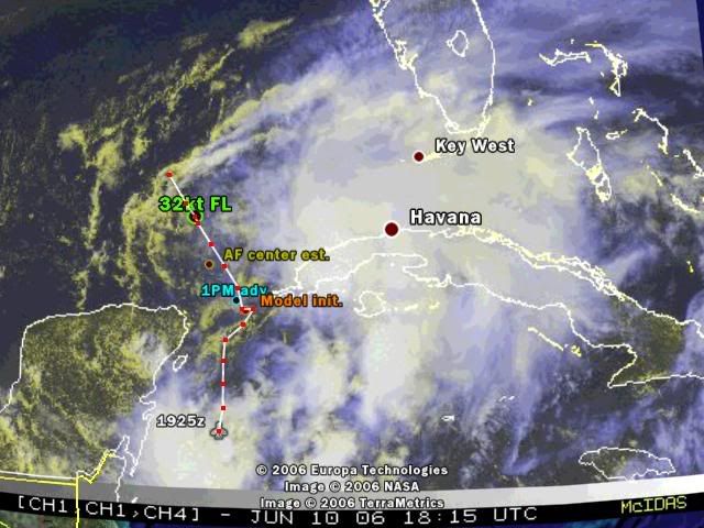
01: 17:36:00; 23.2°N 86.6°W; PA: 994ft; D-Val: -89 ft; Wnd: E (93°) @ 32mph (Max: 33mph); T: 73F; D: 71F; Radar Alt: 935ft
02: 17:36:30; 23.2°N 86.5°W; PA: 1004ft; D-Val: -92 ft; Wnd: E (89°) @ 31mph (Max: 32mph); T: 73F; D: 71F; Radar Alt: 942ft
03: 17:37:00; 23.2°N 86.5°W; PA: 1001ft; D-Val: -92 ft; Wnd: E (88°) @ 30mph (Max: 32mph); T: 73F; D: 71F; Radar Alt: 938ft
04: 17:37:30; 23.1°N 86.5°W; PA: 1033ft; D-Val: -92 ft; Wnd: E (88°) @ 28mph (Max: 29mph); T: 73F; D: 71F; Radar Alt: 974ft
05: 17:38:00; 23.1°N 86.5°W; PA: 1063ft; D-Val: -89 ft; Wnd: E (87°) @ 29mph (Max: 29mph); T: 73F; D: 71F; Radar Alt: 1004ft
06: 17:38:30; 23.1°N 86.5°W; PA: 1056ft; D-Val: -92 ft; Wnd: E (83°) @ 29mph (Max: 29mph); T: 73F; D: 72F; Radar Alt: 994ft
07: 17:39:00; 23.1°N 86.5°W; PA: 1050ft; D-Val: -95 ft; Wnd: E (81°) @ 29mph (Max: 30mph); T: 73F; D: 71F; Radar Alt: 988ft
08: 17:39:30; 23.1°N 86.5°W; PA: 1056ft; D-Val: -95 ft; Wnd: E (80°) @ 29mph (Max: 31mph); T: 73F; D: 71F; Radar Alt: 994ft
09: 17:40:00; 23°N 86.4°W; PA: 1050ft; D-Val: -95 ft; Wnd: E (81°) @ 30mph (Max: 30mph); T: 73F; D: 71F; Radar Alt: 984ft
10: 17:40:30; 23°N 86.4°W; PA: 1060ft; D-Val: -95 ft; Wnd: ENE (76°) @ 30mph (Max: 31mph); T: 72F; D: 72F; Radar Alt: 994ft
11: 17:41:00; 23°N 86.4°W; PA: 1050ft; D-Val: -95 ft; Wnd: ENE (76°) @ 31mph (Max: 32mph); T: 72F; D: 72F; Radar Alt: 984ft
12: 17:41:30; 23°N 86.4°W; PA: 1053ft; D-Val: -95 ft; Wnd: ENE (74°) @ 33mph (Max: 35mph); T: 72F; D: 72F; Radar Alt: 991ft
13: 17:42:00; 23°N 86.4°W; PA: 1056ft; D-Val: -95 ft; Wnd: ENE (76°) @ 30mph (Max: 30mph); T: 72F; D: 72F; Radar Alt: 994ft
14: 17:42:30; **** ****; PA: 1053ft; D-Val: ****; Wnd: ENE (74°) @ 32mph (Max: 33mph); T: 72F; D: 72F; Radar Alt: 984ft
15: 17:43:00; **** ****; PA: 1056ft; D-Val: ****; Wnd: ENE (72°) @ 30mph (Max: 30mph); T: 72F; D: 72F; Radar Alt: 991ft
16: 17:43:30; **** ****; PA: 1050ft; D-Val: ****; Wnd: ENE (75°) @ 31mph (Max: 31mph); T: 73F; D: 72F; Radar Alt: 984ft
17: 17:44:00; **** ****; PA: 1056ft; D-Val: ****; Wnd: ENE (74°) @ 31mph (Max: 32mph); T: 73F; D: 72F; Radar Alt: 991ft
18: 17:44:30; 22.9°N 86.3°W; PA: 1050ft; D-Val: -102 ft; Wnd: ENE (74°) @ 32mph (Max: 32mph); T: 73F; D: 71F; Radar Alt: 981ft
19: 17:45:00; **** ****; PA: 1056ft; D-Val: ****; Wnd: ENE (72°) @ 31mph (Max: 33mph); T: 73F; D: 72F; Radar Alt: 984ft
20: 17:45:30; **** ****; PA: 1056ft; D-Val: ****; Wnd: ENE (71°) @ 30mph (Max: 31mph); T: 73F; D: 72F; Radar Alt: 984ft
Note: **** means data accuracy was suspect
Storm Name: INVEST (AAL)
Mission Number: 01
Flight ID: AF301
Flt Data Number: 13
01: 17:36:00; 23.2°N 86.6°W; PA: 994ft; D-Val: -89 ft; Wnd: E (93°) @ 32mph (Max: 33mph); T: 73F; D: 71F; Radar Alt: 935ft
02: 17:36:30; 23.2°N 86.5°W; PA: 1004ft; D-Val: -92 ft; Wnd: E (89°) @ 31mph (Max: 32mph); T: 73F; D: 71F; Radar Alt: 942ft
03: 17:37:00; 23.2°N 86.5°W; PA: 1001ft; D-Val: -92 ft; Wnd: E (88°) @ 30mph (Max: 32mph); T: 73F; D: 71F; Radar Alt: 938ft
04: 17:37:30; 23.1°N 86.5°W; PA: 1033ft; D-Val: -92 ft; Wnd: E (88°) @ 28mph (Max: 29mph); T: 73F; D: 71F; Radar Alt: 974ft
05: 17:38:00; 23.1°N 86.5°W; PA: 1063ft; D-Val: -89 ft; Wnd: E (87°) @ 29mph (Max: 29mph); T: 73F; D: 71F; Radar Alt: 1004ft
06: 17:38:30; 23.1°N 86.5°W; PA: 1056ft; D-Val: -92 ft; Wnd: E (83°) @ 29mph (Max: 29mph); T: 73F; D: 72F; Radar Alt: 994ft
07: 17:39:00; 23.1°N 86.5°W; PA: 1050ft; D-Val: -95 ft; Wnd: E (81°) @ 29mph (Max: 30mph); T: 73F; D: 71F; Radar Alt: 988ft
08: 17:39:30; 23.1°N 86.5°W; PA: 1056ft; D-Val: -95 ft; Wnd: E (80°) @ 29mph (Max: 31mph); T: 73F; D: 71F; Radar Alt: 994ft
09: 17:40:00; 23°N 86.4°W; PA: 1050ft; D-Val: -95 ft; Wnd: E (81°) @ 30mph (Max: 30mph); T: 73F; D: 71F; Radar Alt: 984ft
10: 17:40:30; 23°N 86.4°W; PA: 1060ft; D-Val: -95 ft; Wnd: ENE (76°) @ 30mph (Max: 31mph); T: 72F; D: 72F; Radar Alt: 994ft
11: 17:41:00; 23°N 86.4°W; PA: 1050ft; D-Val: -95 ft; Wnd: ENE (76°) @ 31mph (Max: 32mph); T: 72F; D: 72F; Radar Alt: 984ft
12: 17:41:30; 23°N 86.4°W; PA: 1053ft; D-Val: -95 ft; Wnd: ENE (74°) @ 33mph (Max: 35mph); T: 72F; D: 72F; Radar Alt: 991ft
13: 17:42:00; 23°N 86.4°W; PA: 1056ft; D-Val: -95 ft; Wnd: ENE (76°) @ 30mph (Max: 30mph); T: 72F; D: 72F; Radar Alt: 994ft
14: 17:42:30; **** ****; PA: 1053ft; D-Val: ****; Wnd: ENE (74°) @ 32mph (Max: 33mph); T: 72F; D: 72F; Radar Alt: 984ft
15: 17:43:00; **** ****; PA: 1056ft; D-Val: ****; Wnd: ENE (72°) @ 30mph (Max: 30mph); T: 72F; D: 72F; Radar Alt: 991ft
16: 17:43:30; **** ****; PA: 1050ft; D-Val: ****; Wnd: ENE (75°) @ 31mph (Max: 31mph); T: 73F; D: 72F; Radar Alt: 984ft
17: 17:44:00; **** ****; PA: 1056ft; D-Val: ****; Wnd: ENE (74°) @ 31mph (Max: 32mph); T: 73F; D: 72F; Radar Alt: 991ft
18: 17:44:30; 22.9°N 86.3°W; PA: 1050ft; D-Val: -102 ft; Wnd: ENE (74°) @ 32mph (Max: 32mph); T: 73F; D: 71F; Radar Alt: 981ft
19: 17:45:00; **** ****; PA: 1056ft; D-Val: ****; Wnd: ENE (72°) @ 31mph (Max: 33mph); T: 73F; D: 72F; Radar Alt: 984ft
20: 17:45:30; **** ****; PA: 1056ft; D-Val: ****; Wnd: ENE (71°) @ 30mph (Max: 31mph); T: 73F; D: 72F; Radar Alt: 984ft
Note: **** means data accuracy was suspect
0 likes
Who is online
Users browsing this forum: Google Adsense [Bot] and 196 guests