Kingarabian wrote:NotSparta wrote:Kingarabian wrote:
That's what happened in late March -- and almost every time when a WWB is generated due to MJO activity. As the MJO enters and leaves the MC, the westerly anomalies start shifting further east and closer to the dateline.
As for the trades, like I said maybe around a month ago, we're going to need a substantial enhancement of the trades for a long period of time to wipe out what has already developed and situated beneath the surface. What we've been seeing the past 4 weeks has been nothing but broken up easterlies that are only slightly enhanced compared to normal. That's why the warm pool has continued to strengthen and expand despite no WWB in the eastern Pacific.
Though it doesn't mean there won't be an El Niño, but a warm pool does not guarantee an El Niño or even a significant change in SSTAs.
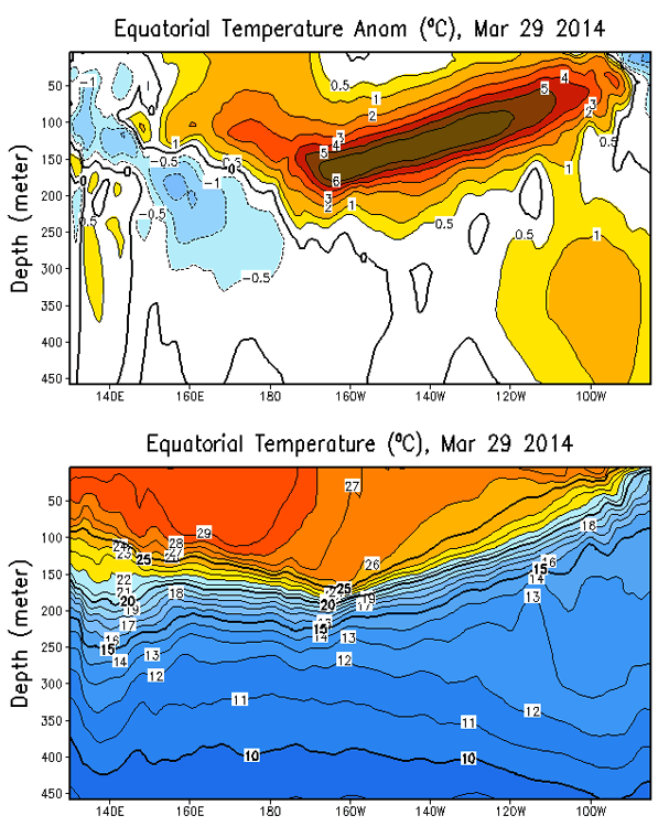
Take 2014, for example - the 2015/16 El Niño did not really get going until another strong warm pool surfaced.
[img]https://uploads.disquscdn.com/images/f216f45e866ca2ecaa55bbdfe30d27a3c092a7f9493367af43f008eaecc8b4ca.gif[img]
I agree. But at the same time we can't dismiss it. Also 2014 was as an El Nino year and the Atlantic hurricane season that year had below average activity.
Historically speaking, we have till June to see if an El Nino will be here for the 2018 hurricane season.
Yes it could change things but it won't always. It definitely needs to be watched.
El Niño did develop, but not until OND. And yes, due to the hyperactive EPAC that year, the ATL had shear and dry/sinking air so activity was greatly reduced, so El Niño is not the only factor.
It is early still, so we'll see how things evolve. El Niño and neutral seem reasonable for this year, imo unlikely that another Niña comes into place with atmosphere beginning to shift against another
This post was probably an opinion of mine, and
in no way is official. Please refer to
http://www.hurricanes.gov for official tropical analysis and advisories.
My website, with lots of tropical wx graphics, including satellite and recon:
http://cyclonicwx.com


