ENSO Updates (2007 thru 2023)
Moderator: S2k Moderators
Forum rules

The posts in this forum are NOT official forecasts and should not be used as such. They are just the opinion of the poster and may or may not be backed by sound meteorological data. They are NOT endorsed by any professional institution or STORM2K. For official information, please refer to products from the National Hurricane Center and National Weather Service.
-
dexterlabio
- Category 5

- Posts: 3406
- Joined: Sat Oct 24, 2009 11:50 pm
Re: ENSO Updates
Correct me if I'm wrong, but if that SST configuration is maintained (especially around Nino 3.4) for another 3 months, then a weak El Nino can be declared? I'm not updated with the trimonthly values, but how many more months of >= 0.5C do we need to get five consecutive El Nino trimonthlies? I think the only thing we're watching for is if that surface warmth would be replaced by cooler patches, or if it will be able to sustain itself in the coming months.
0 likes
Personal Forecast Disclaimer:
The posts in this forum are NOT official forecast and should not be used as such. They are just the opinion of the poster and may or may not be backed by sound meteorological data. They are NOT endorsed by any professional institution or storm2k.org. For official information, please refer to the NHC and NWS products.
The posts in this forum are NOT official forecast and should not be used as such. They are just the opinion of the poster and may or may not be backed by sound meteorological data. They are NOT endorsed by any professional institution or storm2k.org. For official information, please refer to the NHC and NWS products.

Re: ENSO Updates
dexterlabio wrote:Correct me if I'm wrong, but if that SST configuration is maintained (especially around Nino 3.4) for another 3 months, then a weak El Nino can be declared? I'm not updated with the trimonthly values, but how many more months of >= 0.5C do we need to get five consecutive El Nino trimonthlies? I think the only thing we're watching for is if that surface warmth would be replaced by cooler patches, or if it will be able to sustain itself in the coming months.
You need 5 consecutive trimonthlies. Sometimes they will declare a warning if only a trimonthly or two if there was strong confidence and the readings are heading well above 1C it seems given the slow nature of warming and cooling. In weak events, such as 2014, there are lots of bumps but they will declare after the 5 trimonthlies. They had many doubts about that one but because the readings clipped 0.5C long enough they had to. There are reverse cases too like 2012 where they wanted to declare but did not last long enough.
0 likes
The above post and any post by Ntxw is NOT an official forecast and should not be used as such. It is just the opinion of the poster and may or may not be backed by sound meteorological data. It is NOT endorsed by any professional institution including Storm2k. For official information, please refer to NWS products.
Help support Storm2K!

Re: ENSO Updates
During the past week western Nino 3 has cooled down while Nino 4 has warmed up, over all 3.4 should come down to at least + 0.5C if not to + 0.4C on tomorrow's update. IMO.
1 likes
Re: ENSO: CPC June update=50-55% chance of Neutral thru the Fall (CPC Blog - A recipe for Neutral)
LarryWx wrote:The 12Z Euro suggests that the Darwin MTD SLP 6/1-21 will fall back to ~1013.5 from the ~1014.25 for 6/1-15 due to SLP's averaging only ~1012 for 6/16-21. OTOH, the 12Z GFS keeps it up near 1014 for 6/1-21 due to ~1013.5 for 6/16-21. The key I've been focusing on for June as a whole is whether or not it ends up 1014+ as that would be a pretty strong indicator of El Nino later this year based on June Darwin SLP history since 1951. Whereas the 12Z GFS through 6/21 suggests that is a very real possibility with only 1014 being needed 6/22-30, the 12Z Euro suggests that would be quite the challenge as it would mean that 1015 would be needed 6/22-30.
Generally, the Euro is a more accurate model than the GFS though I really don't know for just this specific area. I'll be closely following what the model trend is for the next few days of runs for 6/16-21 to see if it is heading closer to the lower SLP Euro or if it is heading closer to the higher SLP GFS.
Looking at runs just 24 hours later, whereas today's 12Z GFS is still near the 1013.5 mb it was at yesterday in its 12Z run for Darwin for 6/16-21, today's 12Z Euro has risen to near 1013.25 from yesterday's ~1012 for 6-16-21. So, the lower SLP Euro of yesterday has already risen almost all of the way to the higher SLP of the steady GFS. So, now there is pretty good agreement that Darwin will be ~1014 for 6/1-21. I've been focusing on the pretty rare 1014+ for June as a whole as being a pretty significant indicator for an oncoming El Niño if it were to be attained based on 1951-2016 June Darwin SLPs. If June ends up 1014+, I'd be near 75-80% chance for El Niño oncoming. I'll continue to follow.
4 likes
Personal Forecast Disclaimer:
The posts in this forum are NOT official forecasts and should not be used as such. They are just the opinion of the poster and may or may not be backed by sound meteorological data. They are NOT endorsed by any professional institution or storm2k.org. For official information, please refer to the NHC and NWS products.
The posts in this forum are NOT official forecasts and should not be used as such. They are just the opinion of the poster and may or may not be backed by sound meteorological data. They are NOT endorsed by any professional institution or storm2k.org. For official information, please refer to the NHC and NWS products.


Re: ENSO Updates
The UKMO ENSO forecasts for June came out today (at least one their web site). In the forecast, the trend of the ensemble mean continues toward ENSO-neutral conditions during the heart of the hurricane season. There are still some members that predict El Niño during the ASO period.
June forecast

May forecast

June forecast
May forecast
3 likes
-
Kingarabian

- S2K Supporter

- Posts: 15434
- Joined: Sat Aug 08, 2009 3:06 am
- Location: Honolulu, Hawaii
Re: ENSO Updates
Update will.be 0.4C when it comes out. Nino 1+2 is -0.1C
0 likes
The above post and any post by Ntxw is NOT an official forecast and should not be used as such. It is just the opinion of the poster and may or may not be backed by sound meteorological data. It is NOT endorsed by any professional institution including Storm2k. For official information, please refer to NWS products.
Help support Storm2K!
Help support Storm2K!
-
weathaguyry

- Category 5
- Posts: 1272
- Age: 20
- Joined: Wed Jun 15, 2016 5:16 am
- Location: Long Island, NY
Re: ENSO Updates
Ntxw wrote:Update will.be 0.4C when it comes out. Nino 1+2 is -0.1C
Wow! Nino 1+2 is below 0!
0 likes
My posts are only my opinions and NOT official forecasts. For official forecasts, consult the National Hurricane Center or the National Weather Service.
Irene 11', Sandy 12', Fay 20’, Isaias 20’, Elsa 21’, Henri 21’, Ida 21’
Irene 11', Sandy 12', Fay 20’, Isaias 20’, Elsa 21’, Henri 21’, Ida 21’
Re: ENSO Updates
weathaguyry wrote:Ntxw wrote:Update will.be 0.4C when it comes out. Nino 1+2 is -0.1C
Wow! Nino 1+2 is below 0!
It's the first weekly negative reading since November for 1+2
1 likes
The above post and any post by Ntxw is NOT an official forecast and should not be used as such. It is just the opinion of the poster and may or may not be backed by sound meteorological data. It is NOT endorsed by any professional institution including Storm2k. For official information, please refer to NWS products.
Help support Storm2K!
Help support Storm2K!
-
cycloneye

- Admin

- Posts: 139067
- Age: 67
- Joined: Thu Oct 10, 2002 10:54 am
- Location: San Juan, Puerto Rico
Re: ENSO Updates
CPC weekly update that has Nino 3.4 down to +0.4C and Nino 1+2 down to -0.1C.

0 likes
Visit the Caribbean-Central America Weather Thread where you can find at first post web cams,radars
and observations from Caribbean basin members Click Here
and observations from Caribbean basin members Click Here
-
Kingarabian
- S2K Supporter
- Posts: 15434
- Joined: Sat Aug 08, 2009 3:06 am
- Location: Honolulu, Hawaii
Re: ENSO Updates
LongPaddock still hasn't added the daily SOI value for yesterday. With the numbers I averaged out, 1014.22 @ Tahiti, and 1014.90 @ Darwin, it would come in around -22.00. LongPaddock sometimes usually slightly different pressures so it could be less, but it'll be -15 at minimum.
0 likes
RIP Kobe Bryant
Re: ENSO Updates
Kingarabian wrote:LongPaddock still hasn't added the daily SOI value for yesterday. With the numbers I averaged out, 1014.22 @ Tahiti, and 1014.90 @ Darwin, it would come in around -22.00. LongPaddock sometimes usually slightly different pressures so it could be less, but it'll be -15 at minimum.
Hey King,
A 1014.22 at Tahiti and a 1014.90 at Darwin would yield about -14 rather than -22. Is the -22 a typo?
1 likes
Personal Forecast Disclaimer:
The posts in this forum are NOT official forecasts and should not be used as such. They are just the opinion of the poster and may or may not be backed by sound meteorological data. They are NOT endorsed by any professional institution or storm2k.org. For official information, please refer to the NHC and NWS products.
The posts in this forum are NOT official forecasts and should not be used as such. They are just the opinion of the poster and may or may not be backed by sound meteorological data. They are NOT endorsed by any professional institution or storm2k.org. For official information, please refer to the NHC and NWS products.
-
Kingarabian
- S2K Supporter
- Posts: 15434
- Joined: Sat Aug 08, 2009 3:06 am
- Location: Honolulu, Hawaii
Re: ENSO Updates
LarryWx wrote:Kingarabian wrote:LongPaddock still hasn't added the daily SOI value for yesterday. With the numbers I averaged out, 1014.22 @ Tahiti, and 1014.90 @ Darwin, it would come in around -22.00. LongPaddock sometimes usually slightly different pressures so it could be less, but it'll be -15 at minimum.
Hey King,
A 1014.22 at Tahiti and a 1014.90 at Darwin would yield about -14 rather than -22. Is the -22 a typo?
You're right, that's what I was leaning on. That's what I was thinking since on June 10 it was:
Code: Select all
2017 161 1014.21 1015.05 -14.97But in 2015:
Code: Select all
2015 284 1014.85 1014.85  -18.63
2015 285 1014.25 1014.90  -22.82
Are numbers from past years irrelevant to the current year?
0 likes
RIP Kobe Bryant
Re: ENSO Updates
Kingarabian wrote:LarryWx wrote:Kingarabian wrote:LongPaddock still hasn't added the daily SOI value for yesterday. With the numbers I averaged out, 1014.22 @ Tahiti, and 1014.90 @ Darwin, it would come in around -22.00. LongPaddock sometimes usually slightly different pressures so it could be less, but it'll be -15 at minimum.
Hey King,
A 1014.22 at Tahiti and a 1014.90 at Darwin would yield about -14 rather than -22. Is the -22 a typo?
You're right, that's what I was leaning on. That's what I was thinking since on June 10 it was:Code: Select all
2017 161 1014.21 1015.05 -14.97
But in 2015:Code: Select all
2015 284 1014.85 1014.85  -18.63
2015 285 1014.25 1014.90  -22.82
Are numbers from past years irrelevant to the current year?
OK, I see the reason for the confusion. Yes, past years are relevant. But here's the key. Days 284 and 285 are from October. Each month has a different formula.
1 likes
Personal Forecast Disclaimer:
The posts in this forum are NOT official forecasts and should not be used as such. They are just the opinion of the poster and may or may not be backed by sound meteorological data. They are NOT endorsed by any professional institution or storm2k.org. For official information, please refer to the NHC and NWS products.
The posts in this forum are NOT official forecasts and should not be used as such. They are just the opinion of the poster and may or may not be backed by sound meteorological data. They are NOT endorsed by any professional institution or storm2k.org. For official information, please refer to the NHC and NWS products.
-
Kingarabian
- S2K Supporter
- Posts: 15434
- Joined: Sat Aug 08, 2009 3:06 am
- Location: Honolulu, Hawaii
Re: ENSO Updates
LarryWx wrote:Kingarabian wrote:LarryWx wrote:
Hey King,
A 1014.22 at Tahiti and a 1014.90 at Darwin would yield about -14 rather than -22. Is the -22 a typo?
You're right, that's what I was leaning on. That's what I was thinking since on June 10 it was:Code: Select all
2017 161 1014.21 1015.05 -14.97
But in 2015:Code: Select all
2015 284 1014.85 1014.85  -18.63
2015 285 1014.25 1014.90  -22.82
Are numbers from past years irrelevant to the current year?
OK, I see the reason for the confusion. Yes, past years are relevant. But here's the key. Days 284 and 285 are from October. Each month has a different formula.
Okay, thank you for your clarification. I see the differences now for each month.
0 likes
RIP Kobe Bryant
-
cycloneye
- Admin
- Posts: 139067
- Age: 67
- Joined: Thu Oct 10, 2002 10:54 am
- Location: San Juan, Puerto Rico
Re: ENSO Updates
Another month in postive for PDO as May PDO index is at +0.88C.
@bhensonweather
May PDO is +0.88, per Nate Mantua. That's an unprecedented 40th consec. month of positive PDO. Data go back to 1900
https://twitter.com/bhensonweather/status/875415024755499008
@bhensonweather
May PDO is +0.88, per Nate Mantua. That's an unprecedented 40th consec. month of positive PDO. Data go back to 1900
https://twitter.com/bhensonweather/status/875415024755499008
1 likes
Visit the Caribbean-Central America Weather Thread where you can find at first post web cams,radars
and observations from Caribbean basin members Click Here
and observations from Caribbean basin members Click Here
-
weathaguyry
- Category 5
- Posts: 1272
- Age: 20
- Joined: Wed Jun 15, 2016 5:16 am
- Location: Long Island, NY
Re: ENSO Updates
Same exact value as May 2004 
0 likes
My posts are only my opinions and NOT official forecasts. For official forecasts, consult the National Hurricane Center or the National Weather Service.
Irene 11', Sandy 12', Fay 20’, Isaias 20’, Elsa 21’, Henri 21’, Ida 21’
Irene 11', Sandy 12', Fay 20’, Isaias 20’, Elsa 21’, Henri 21’, Ida 21’
-
Kingarabian
- S2K Supporter
- Posts: 15434
- Joined: Sat Aug 08, 2009 3:06 am
- Location: Honolulu, Hawaii
Re: ENSO Updates
cycloneye wrote:May PDO index is again positive at +0.88C.
https://twitter.com/bhensonweather/status/875415024755499008
Yup. It's going to come in stronger for June as well.
1 likes
RIP Kobe Bryant
-
cycloneye
- Admin
- Posts: 139067
- Age: 67
- Joined: Thu Oct 10, 2002 10:54 am
- Location: San Juan, Puerto Rico
Re: ENSO Updates
No El Nino for thr rest of 2017 if this plume of all the models is right.

1 likes
Visit the Caribbean-Central America Weather Thread where you can find at first post web cams,radars
and observations from Caribbean basin members Click Here
and observations from Caribbean basin members Click Here
-
Kingarabian
- S2K Supporter
- Posts: 15434
- Joined: Sat Aug 08, 2009 3:06 am
- Location: Honolulu, Hawaii
Re: ENSO Updates
Tug of war continues.
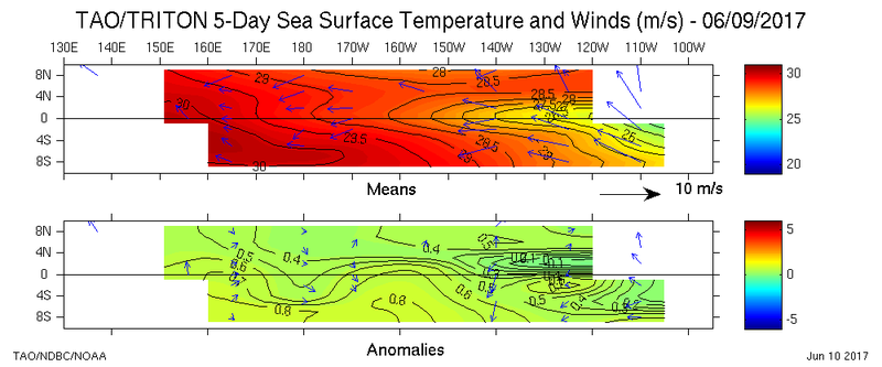
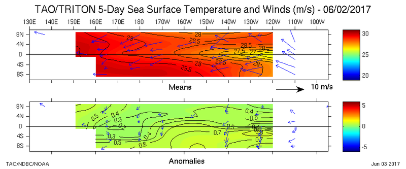
Relaxed easterlies have a WWB east of 120W have warmed the subsurface anomalies once again:
June 7:

June 12:

That cool pool will shrink once again as we saw in April/May with the SOI tanking and a WWB kicks off near the dateline. So expect Nino regions to be at weak El Nino levels until something changes in the grand scheme of things, and expect Nino 1+2, and Nino 3 to ramp up. There will be some oscillations here and there in the daily's, but the GFS and Euro continue to consistently show predominately >= -10 in the daily values for the entirety of their runs.
Relaxed easterlies have a WWB east of 120W have warmed the subsurface anomalies once again:
June 7:
June 12:
That cool pool will shrink once again as we saw in April/May with the SOI tanking and a WWB kicks off near the dateline. So expect Nino regions to be at weak El Nino levels until something changes in the grand scheme of things, and expect Nino 1+2, and Nino 3 to ramp up. There will be some oscillations here and there in the daily's, but the GFS and Euro continue to consistently show predominately >= -10 in the daily values for the entirety of their runs.
2 likes
RIP Kobe Bryant
Who is online
Users browsing this forum: Cpv17 and 189 guests