
SOI has been really tanking the past week, to remind us that the atmosphere is still very much El Nino
highlighted the daily values. To the right of them is 30 day average. April will finish with another strong reading as the whole month has seen negative readings only.
15 Apr 2016 1009.36 1011.25 -30.80 -11.62 -13.36
16 Apr 2016 1009.91 1010.95 -24.70 -12.70 -13.27
17 Apr 2016 1009.99 1010.35 -19.80 -13.55 -13.27
18 Apr 2016 1009.74 1010.10 -19.80 -14.21 -13.26
19 Apr 2016 1010.00 1010.50 -20.80 -14.76 -13.25
20 Apr 2016 1009.90 1013.80 -45.30 -16.08 -13.48
21 Apr 2016 1009.11 1011.75 -36.20 -17.26 -13.57
ENSO Updates (2007 thru 2023)
Moderator: S2k Moderators
Forum rules

The posts in this forum are NOT official forecasts and should not be used as such. They are just the opinion of the poster and may or may not be backed by sound meteorological data. They are NOT endorsed by any professional institution or STORM2K. For official information, please refer to products from the National Hurricane Center and National Weather Service.
Re: ENSO Updates
0 likes
The above post and any post by Ntxw is NOT an official forecast and should not be used as such. It is just the opinion of the poster and may or may not be backed by sound meteorological data. It is NOT endorsed by any professional institution including Storm2k. For official information, please refer to NWS products.
Help support Storm2K!
-
Kingarabian

- S2K Supporter

- Posts: 15434
- Joined: Sat Aug 08, 2009 3:06 am
- Location: Honolulu, Hawaii
Re: ENSO Updates
Ntxw wrote:SOI has been really tanking the past week, to remind us that the atmosphere is still very much El Nino
highlighted the daily values. To the right of them is 30 day average. April will finish with another strong reading as the whole month has seen negative readings only.
15 Apr 2016 1009.36 1011.25 -30.80 -11.62 -13.36
16 Apr 2016 1009.91 1010.95 -24.70 -12.70 -13.27
17 Apr 2016 1009.99 1010.35 -19.80 -13.55 -13.27
18 Apr 2016 1009.74 1010.10 -19.80 -14.21 -13.26
19 Apr 2016 1010.00 1010.50 -20.80 -14.76 -13.25
20 Apr 2016 1009.90 1013.80 -45.30 -16.08 -13.48
21 Apr 2016 1009.11 1011.75 -36.20 -17.26 -13.57
Yup. And as we saw in 2014, an uncooperative SOI were one of the precursors of simply having a warm neutral rather than a full blown Nino.
0 likes
RIP Kobe Bryant

Re: ENSO Updates
Not really surprising considering over the past month 2 low pressure systems have been out past the date line in the shem. A reading next month may be more accurate. Current SST AVHRR data which i believe is reliable, 3.4 is now at 1.05129 
0 likes
Re: ENSO Updates
stormwise wrote:Not really surprising considering over the past month 2 low pressure systems have been out past the date line in the shem. A reading next month may be more accurate. Current SST AVHRR data which i believe is reliable, 3.4 is now at 1.05129
What do you mean by this? The SOI likely won't react until after the ocean is coupled which is still several months away for a Nina to control the atmosphere after the SST's are established, which won't likely happen in May. And for that to change you will need stronger trades.
0 likes
The above post and any post by Ntxw is NOT an official forecast and should not be used as such. It is just the opinion of the poster and may or may not be backed by sound meteorological data. It is NOT endorsed by any professional institution including Storm2k. For official information, please refer to NWS products.
Help support Storm2K!
Help support Storm2K!
Re: ENSO Updates
1.1C this week. Biggest change comes from 1+2 at -0.6C
0 likes
The above post and any post by Ntxw is NOT an official forecast and should not be used as such. It is just the opinion of the poster and may or may not be backed by sound meteorological data. It is NOT endorsed by any professional institution including Storm2k. For official information, please refer to NWS products.
Help support Storm2K!
Help support Storm2K!
-
cycloneye

- Admin

- Posts: 139055
- Age: 67
- Joined: Thu Oct 10, 2002 10:54 am
- Location: San Juan, Puerto Rico
Re: ENSO Updates
Text of CPC weekly update of 4/25/16 that has Nino 3.4 down to +1.1C.
http://www.cpc.noaa.gov/products/analys ... ts-web.pdf
http://www.cpc.noaa.gov/products/analys ... ts-web.pdf
0 likes
Visit the Caribbean-Central America Weather Thread where you can find at first post web cams,radars
and observations from Caribbean basin members Click Here
and observations from Caribbean basin members Click Here

Re: ENSO Updates
Ntxw wrote:1.1C this week. Biggest change comes from 1+2 at -0.6C
Unlike '83 & '98, also Nino 3 has had a deep fall the last couple of weeks, down to +0.6C. I know Nino 3.1 is taking its sweet time to cool down this year but at this same time in '98 Nino 3 was at +1.6C with Nino 1+2 at a whopping +3.2C.
0 likes
Re: ENSO Updates
Ntxw wrote:stormwise wrote:Not really surprising considering over the past month 2 low pressure systems have been out past the date line in the shem. A reading next month may be more accurate. Current SST AVHRR data which i believe is reliable, 3.4 is now at 1.05129
What do you mean by this? The SOI likely won't react until after the ocean is coupled which is still several months away for a Nina to control the atmosphere after the SST's are established, which won't likely happen in May. And for that to change you will need stronger trades.
Pressure measurement readings over Tahiti will fluctuate with low pressure systems.

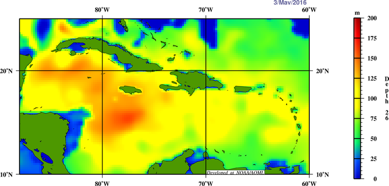
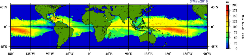
By the end of next month i suspect the atmospheric nino coupling be will non existent and we may well be deep into neutral territory. Also note the warm water in the Atlantic on this sst chart. Holding onto the idea of a persistent nino with a enhanced E-pac/CPac season imho opinion is just gaping at straws. This Atlantic season may be quite dangerous in the western caribbean.

Edit add
Last edited by stormwise on Tue Apr 26, 2016 2:14 am, edited 1 time in total.
0 likes

Re: CPC 4/25/16 update: Nino 3.4 down to +1.1C / Nino 1+2 down to -0.6C

CFS has relatively reduced trades for next month.

0 likes

Re: ENSO Updates
Nino 3.4 has cooled steadily. 1+2 has been warming up. This is the problem with relying on 1+2. Changes there happen rapidly even week to week. It is not a stable reliable source. A change in winds can alter 1.2 in a hurry such has been seen the past few days.
0 likes
The above post and any post by Ntxw is NOT an official forecast and should not be used as such. It is just the opinion of the poster and may or may not be backed by sound meteorological data. It is NOT endorsed by any professional institution including Storm2k. For official information, please refer to NWS products.
Help support Storm2K!
Help support Storm2K!
Re: ENSO Updates
Ntxw wrote:Nino 3.4 has cooled steadily. 1+2 has been warming up. This is the problem with relying on 1+2. Changes there happen rapidly even week to week. It is not a stable reliable source. A change in winds can alter 1.2 in a hurry such has been seen the past few days.
Yes, it is not that reliable but it is still much cooler than this same time '83 & '98.
0 likes
Re: ENSO Updates
Yeah and it is not as cool in the PDO areas, or just south of Enso near South America as 2007 or 2010 either which was a rapid La Nina response. There are just not that many analogs with similar spatial SST's to work with.
0 likes
The above post and any post by Ntxw is NOT an official forecast and should not be used as such. It is just the opinion of the poster and may or may not be backed by sound meteorological data. It is NOT endorsed by any professional institution including Storm2k. For official information, please refer to NWS products.
Help support Storm2K!
Help support Storm2K!
Re: ENSO Updates
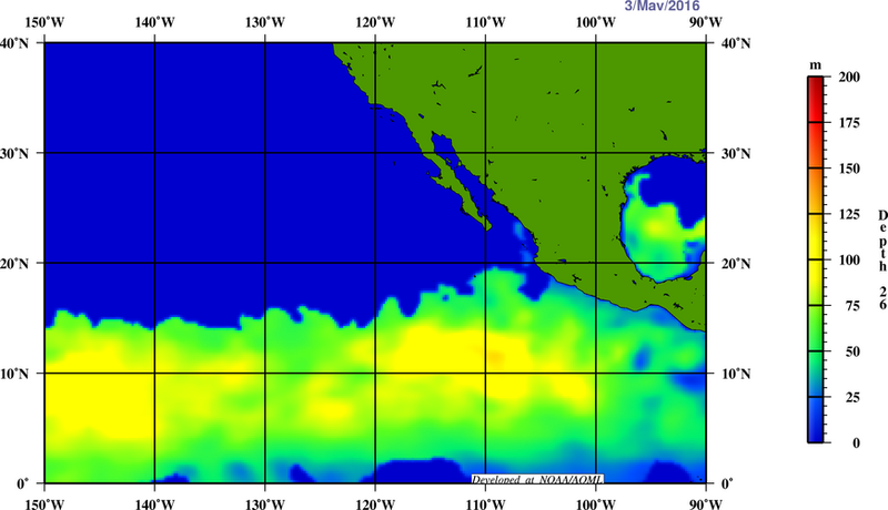
May is an important month for ENSO. Zonal winds during this month can propel or stint the growth of El Nino or La Nina, over the dateline. Last year WWB's in May really took the El Nino to an elevated level, while in 2014 trades cut it down. Of the past 3 transitions from El Nino to La Nina May featured bursts of trades in the western ENSO regions. You can have westerlies in the eastern regions but the west it's an important factor. You need to push the warmer waters of the WPAC west and allow the cooler east to penetrate. You don't have to have them in April, but it's hard to avoid in May for La Nina. Especially for a stronger event.


Will we get stronger than normal trades?
Last week of April, May tbd. So far the stronger than normal trades the past couple of weeks has been over in the Atlantic tropics. As seen far right of hovmollers in blue.


Will we get stronger than normal trades?
Last week of April, May tbd. So far the stronger than normal trades the past couple of weeks has been over in the Atlantic tropics. As seen far right of hovmollers in blue.
0 likes
The above post and any post by Ntxw is NOT an official forecast and should not be used as such. It is just the opinion of the poster and may or may not be backed by sound meteorological data. It is NOT endorsed by any professional institution including Storm2k. For official information, please refer to NWS products.
Help support Storm2K!
Help support Storm2K!
Re: ENSO Updates
Nino 3.4 down to 0.8C this week
0 likes
The above post and any post by Ntxw is NOT an official forecast and should not be used as such. It is just the opinion of the poster and may or may not be backed by sound meteorological data. It is NOT endorsed by any professional institution including Storm2k. For official information, please refer to NWS products.
Help support Storm2K!
Help support Storm2K!
-
cycloneye
- Admin
- Posts: 139055
- Age: 67
- Joined: Thu Oct 10, 2002 10:54 am
- Location: San Juan, Puerto Rico
Re: ENSO Updates
Text od CPC weekly update that has Nino 3.4 down to +0.8C.
http://www.cpc.noaa.gov/products/analys ... ts-web.pdf
http://www.cpc.noaa.gov/products/analys ... ts-web.pdf
0 likes
Visit the Caribbean-Central America Weather Thread where you can find at first post web cams,radars
and observations from Caribbean basin members Click Here
and observations from Caribbean basin members Click Here

Re: ENSO Updates
ERSST for April was at 1.18C - indicating moderate El Nino conditions. ONI for FMA was down to 1.56, while the JFM was reduced to 1.91
0 likes
All posts by Dean_175 are NOT official forecasts and should not be used as such. They are just the opinion of the poster and may or may not be backed by sound meteorological data. They are NOT endorsed by any professional institution or storm2k.org. For official information, please refer to the NHC and NWS products.
-
Andrew92

- S2K Supporter
- Posts: 3247
- Age: 40
- Joined: Mon Jun 16, 2003 12:35 am
- Location: Phoenix, Arizona
Re: ENSO Updates
The following post is NOT an official forecast and should not be used as such. It is just the opinion of the poster and may or may not be backed by sound meteorological data. It is NOT endorsed by any professional institution or storm2k.org. For official information, please refer to the NHC and NWS products.
I know I have seen data indicating that a La Nina is almost certainly coming together. While cold anomalies aren't completely at the surface in the Equator, they are reaching there. Therefore, I think it is just a matter of time before we see a La Nina....at the Equator.
But the EPAC MDR remains a hot bed overall. I would be very intrigued to find out what sub-surface anomalies are like between about 10 and 20 degrees north, from Central America west to maybe 140 degrees west or so. Even with La Nina, if that important area remains warm, the EPAC will probably still be busy. I'm not sold it will completely shut down the Atlantic, but storms will probably struggle in the tropical latitudes, until or unless they get a little farther north.
However, while that profile may temper the Atlantic a little, it doesn't mean one big one can't hit. A similar EPAC SST profile happened in 1959 and 1992....the years of Gracie and Andrew. (Also of Dot and Iniki, yikes!) I thought 1983, but I am getting less convinced of that as an analog, mostly because there were still healthy warm anomalies far east at the Equator that year. There were no warm anomalies in that same location in 1959 or 1992. It just seems like La Nina will make a presence that far east again this year.
But another surprise year, albeit weaker of an analog than 1959 and 1992, has just popped up on my radar. Try not to be alarmed, but I am now looking at 1985. I reviewed all the years since 1951 and noticed last night that while there was a healthy La Nina at the Equator in 1985, there actually was a weak warm pool in the EPAC MDR. Nonetheless, that was still a busy EPAC season. And while that is often described as a busy Atlantic year, I actually notice a couple similarities with namely 1959! (But some with 1992 as well.) Other than Gloria, tropical cyclones just could not get going south of 20 degrees. Instead, almost all those storms that hit the US that year were homegrown, and began ramping up in the Gulf of Mexico, at about 25 degrees. The Caribbean, like both 1959 and 1992, had little activity that year! And there really were almost as many landfalls in 1959 as in 1985 if you think about it, especially in the Gulf. They just had a higher success rate in becoming hurricanes in 1985 than in 1959. There was also no Hawaiian hurricane that year, unlike 1959 and 1992. Nele was actually somewhat close, but too far west.
But again, don't freak out by the 1985 mention too much. Even I am surprised to mention that year, but the EPAC MDR warm pool was still very weak next to 1959 and 1992, and I hazard a guess it will look much weaker than this year if trends continue, which would probably not favor as many hurricanes as that year. But it still suggests homegrown storms overall, and a rather underwhelming MDR and Caribbean, with still potentially one doozy. Remember, it only takes one!
-Andrew92
0 likes
Re: ENSO Updates
0 likes
Who is online
Users browsing this forum: Google Adsense [Bot], NotSparta, Sciencerocks, SFLcane and 87 guests