

stormwise wrote:
That area known as the manatu box has some very warm anom's beginning to show up on the plots.

I just googled manatu box and this thread was the only result returned. Could you please provide a link to anything about this?
Moderator: S2k Moderators

stormwise wrote:
That area known as the manatu box has some very warm anom's beginning to show up on the plots.


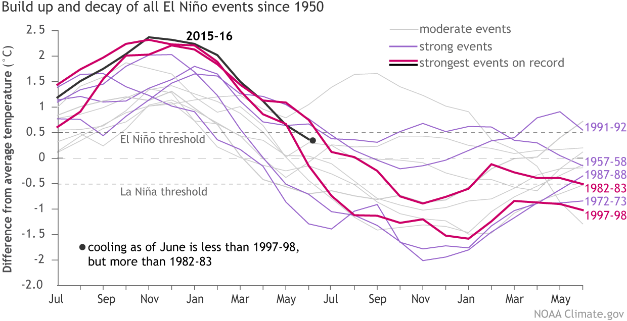
dexterlabio wrote:Would it be a first if a super El Nino year like 2015 precedes a neutral year? The big Nino events like in 1972, 1982, 1997 and 2009 were all followed by La Nina. Although someone could always argue that there's a first for everything...
Ptarmigan wrote:dexterlabio wrote:Would it be a first if a super El Nino year like 2015 precedes a neutral year? The big Nino events like in 1972, 1982, 1997 and 2009 were all followed by La Nina. Although someone could always argue that there's a first for everything...
1897-1898 and 1983-1984 were a weak to moderate La Nina following strong El Nino.
MEI 1871-2005
http://www.esrl.noaa.gov/psd/enso/mei.e ... e.ext.html

BigA wrote:Earlier today Michael Ventrice tweeted the ECMWF ensemble forecast of 850 mb zonal wind anomalies (5N-5S). Note the increased easterlies predicted over the equatorial Pacific during the next two weeks. This has the potential to increase upwelling and thus cause greater cooling in that region.


CaliforniaResident wrote:Could this be like failure of much predicted El Nino to develop in 2014-2015 that morphed into the super El Nino the year afterwards?
La Nina fails to develop this summer and fall but the atmospheric conditions set themselves up (PDO goes to neutral this fall and flips to negative in winter) and we get a very strong La Nina set in the summer of 2017 that carries us through the springs of 2018 and possibly beyond.
Ntxw wrote:CaliforniaResident wrote:Could this be like failure of much predicted El Nino to develop in 2014-2015 that morphed into the super El Nino the year afterwards?
La Nina fails to develop this summer and fall but the atmospheric conditions set themselves up (PDO goes to neutral this fall and flips to negative in winter) and we get a very strong La Nina set in the summer of 2017 that carries us through the springs of 2018 and possibly beyond.
That is a reasonable possibility. The first year weak Nina being a sacrificial lamb to change the background state and better precondition the following year. ...

BigA wrote:Earlier today Michael Ventrice tweeted the ECMWF ensemble forecast of 850 mb zonal wind anomalies (5N-5S). Note the increased easterlies predicted over the equatorial Pacific during the next two weeks. This has the potential to increase upwelling and thus cause greater cooling in that region.

Users browsing this forum: No registered users and 73 guests


