ENSO Updates (2007 thru 2023)

This is the general tropical discussion area. Anyone can take their shot at predicting a storms path.

Moderator: S2k Moderators

Forum rules

The posts in this forum are NOT official forecasts and should not be used as such. They are just the opinion of the poster and may or may not be backed by sound meteorological data. They are NOT endorsed by any professional institution or STORM2K. For official information, please refer to products from the National Hurricane Center and National Weather Service.

Help Support Storm2K
Message
Author
User avatar
NotSparta
Professional-Met
Professional-Met
Posts: 1645
Age: 22
Joined: Fri Aug 18, 2017 8:24 am
Location: Naples, FL
Contact:

Re: ENSO:

#8901 Postby NotSparta » Wed Mar 07, 2018 5:24 am

Digital-TC-Chaser wrote:Image

Image

It gets tossed about quite alot i know. But what be the odds about a nina modoki latter in the year.

Image


Happened last spring before the Niña died
0 likes   
This post was probably an opinion of mine, and in no way is official. Please refer to http://www.hurricanes.gov for official tropical analysis and advisories.

My website, with lots of tropical wx graphics, including satellite and recon: http://cyclonicwx.com

User avatar
NDG
S2K Supporter
S2K Supporter
Posts: 14933
Joined: Sun Jul 09, 2006 10:14 pm
Location: Orlando, FL

Re: ENSO: CPC 3/5/18 update: Niño 3.4 up to -0.8C / ONI for DJF up to -0.9C

#8902 Postby NDG » Wed Mar 07, 2018 8:39 am

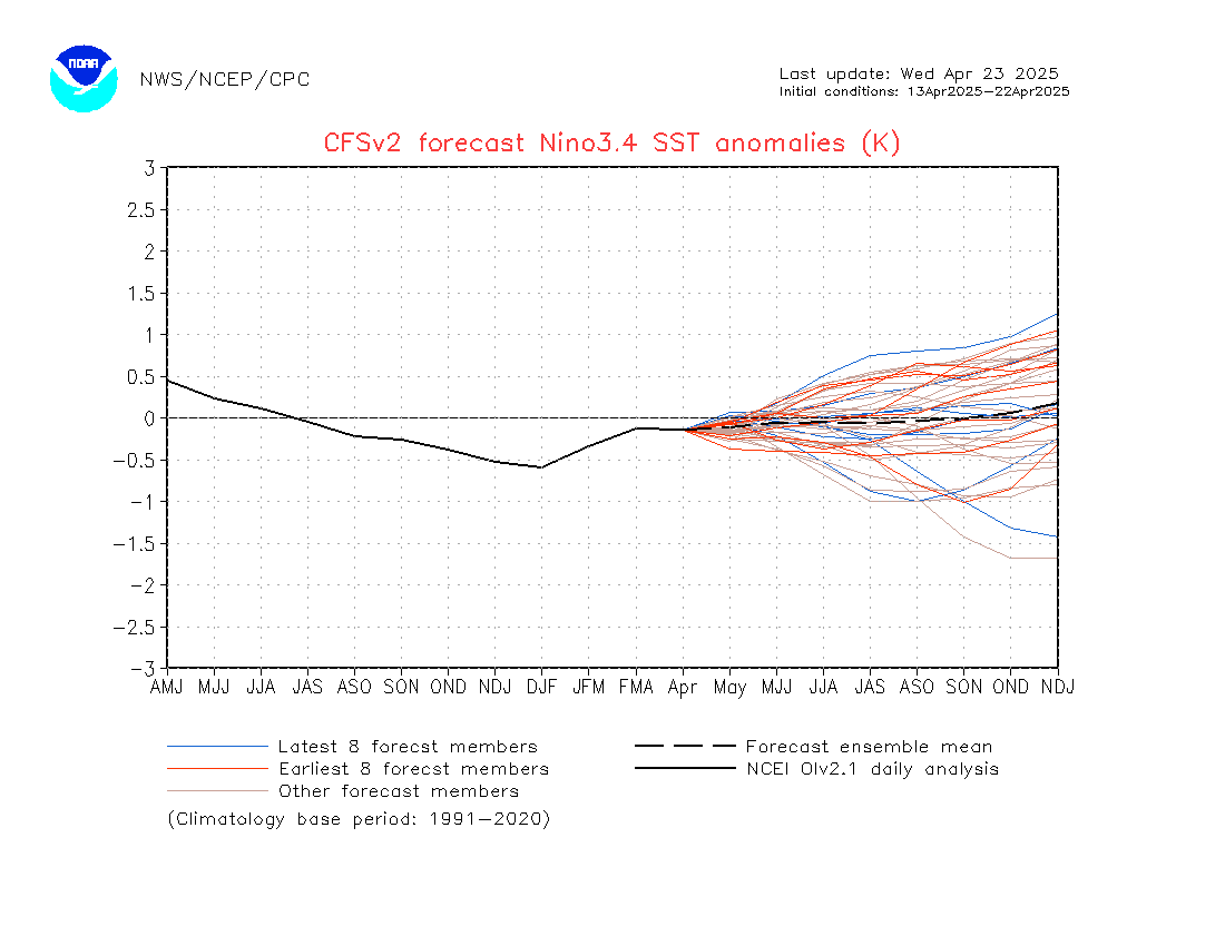
CyclonicFury wrote:CFS certainly isn’t the most reliable model when it comes to ENSO, but it is worth noting that not one ensemble member of the latest set is forecasting El Niño conditions this fall. It’s also interesting to note that the March CanSIPS came in slightly cooler.
Image


Is not like the ECMWF is any better during the Spring Barrier.
0 likes   

User avatar
Kingarabian
S2K Supporter
S2K Supporter
Posts: 15433
Joined: Sat Aug 08, 2009 3:06 am
Location: Honolulu, Hawaii

Re: ENSO: ONI for DJF up to -0.9C

#8903 Postby Kingarabian » Thu Mar 08, 2018 2:06 am

Since ENSO is seeing 2014 comparisons, I thought this would be relevant:

Unusually warm Indian Ocean sea surface temperatures help to arrest development of El Niño in 2014


Lu Dong and Michael McPhaden published a paper in Scientific Reports on 2 February 2018 that describe how in 2014, warm sea surface temperatures (SSTs) in the Indian Ocean weakened westerly wind anomalies in the Pacific and helped to arrest the development of a widely anticipated major El Niño. They demonstrated the processes involved using an ensemble of coupled numerical experiments in which observed Indian Ocean SST anomalies in 2014–15 were prescribed but the Pacific Ocean-atmosphere system was free to evolve. Results confirmed that warm SST anomalies in the Indian Ocean created conditions that would have favored strengthening trade winds in the Pacific in 2014 such that only borderline El Niño conditions were evident by the end of the year.

Dong, L. and M.J. McPhaden, 2018: Unusually warm Indian Ocean sea surface temperatures help to arrest development of El Niño in 2014. Science Reports, 8, 2249, doi:10.1038/s41598-018-20294-4.


https://www.pmel.noaa.gov/gtmba/feature ... lopment-el
Last edited by Kingarabian on Thu Mar 08, 2018 2:30 am, edited 1 time in total.
0 likes   
RIP Kobe Bryant

User avatar
Kingarabian
S2K Supporter
S2K Supporter
Posts: 15433
Joined: Sat Aug 08, 2009 3:06 am
Location: Honolulu, Hawaii

Re: ENSO: ONI for DJF up to -0.9C

#8904 Postby Kingarabian » Thu Mar 08, 2018 2:21 am

A look at the sub-surface developments per the TAO Buoys:

Image
3 likes   
RIP Kobe Bryant

User avatar
cycloneye
Admin
Admin
Posts: 139027
Age: 67
Joined: Thu Oct 10, 2002 10:54 am
Location: San Juan, Puerto Rico

Re: ENSO: CPC March update: La Niña to Neutral March-May / Neutral likely rest of 2018 /33% of El Niño by ASO

#8905 Postby cycloneye » Thu Mar 08, 2018 9:54 am

CPC monthly update of 3/8/18 has La Niña ending in the March thru May period and then Neutral will prevail thru the rest of 2018,however El Niño chances have gone up from 28% in the Febuary update to now 33%.

EL NIÑO/SOUTHERN OSCILLATION (ENSO)
DIAGNOSTIC DISCUSSION
issued by
CLIMATE PREDICTION CENTER/NCEP/NWS
and the International Research Institute for Climate and Society
08 March 2018

ENSO Alert System Status: La Niña Advisory


Synopsis: A transition from La Niña to ENSO-neutral is most likely (~55% chance) during the March-May season, with neutral conditions likely to continue into the second half of the year.

During February 2018, La Niña weakened, but was still reflected by below-average sea surface temperatures (SSTs) in the east-central equatorial Pacific Ocean [Fig. 1]. The latest weekly index values were -0.8°C and -0.6°C in the Niño-3.4 and Niño-3 regions, respectively, and were near zero in the surrounding Niño.4 and Niño1+2 regions [Fig. 2]. While negative anomalies were maintained near the surface, the sub-surface temperature anomalies (averaged across 180°-100°W) warmed to near zero [Fig. 3]. This warming was due to the eastward propagation of above-average temperatures along the thermocline in association with a downwelling equatorial oceanic Kelvin wave [Fig. 4]. The atmospheric anomalies typical of La Niña weakened considerably across the tropical Pacific. Convection was suppressed near Indonesia and was only weakly enhanced over the far western Pacific [Fig. 5]. Also, low-level wind anomalies were westerly over the western and central Pacific, while upper-level winds remained anomalously westerly over the eastern Pacific. Overall, the ocean and atmosphere system suggests La Niña is weakening.

Most models in the IRI/CPC plume predict La Niña will decay and return to ENSO-neutral during the Northern Hemisphere spring 2018 [Fig. 6]. The forecast consensus similarly favors a transition during the spring, with a continuation of ENSO-neutral conditions through the summer. In summary, a transition from La Niña to ENSO-neutral is most likely (~55% chance) during the March-May season, with neutral conditions likely to continue into the second half of the year (click CPC/IRI consensus forecast for the chance of each outcome for each 3-month period).


http://www.cpc.noaa.gov/products/analys ... disc.shtml

https://iri.columbia.edu/our-expertise/ ... -cpc_plume


Image
0 likes   
Visit the Caribbean-Central America Weather Thread where you can find at first post web cams,radars
and observations from Caribbean basin members Click Here

User avatar
cycloneye
Admin
Admin
Posts: 139027
Age: 67
Joined: Thu Oct 10, 2002 10:54 am
Location: San Juan, Puerto Rico

Re: ENSO: CPC March update: La Niña to Neutral March-May / Neutral likely rest of 2018 / Up to 33% of El Niño by ASO

#8906 Postby cycloneye » Thu Mar 08, 2018 1:28 pm

As always,the ENSO CPC blog has interesting things to look at about how they reached the conclusions about what to expect for ENSO in the next few months.

ENSO CPC Blog

Image

In fact, the Pacific Meridional Mode index (maintained by our guest blog author Dan Vimont) is the most positive it’s been in years. The contrast between warmer north and cooler south can influence wind patterns along the equator, thereby influencing ENSO. Of course, the global climate system is big and complicated, and it’s too early to say if this strong PMM will be a major factor as the year goes on… but you can bet we’ll be watching it.

Image
0 likes   
Visit the Caribbean-Central America Weather Thread where you can find at first post web cams,radars
and observations from Caribbean basin members Click Here

User avatar
StruThiO
Category 3
Category 3
Posts: 821
Age: 24
Joined: Fri Sep 15, 2017 5:51 am
Location: Currently Portland, OR. Raised in Jax, FL.

Re: ENSO: CPC March update: La Niña to Neutral March-May / Neutral likely rest of 2018 / Up to 33% of El Niño by ASO

#8907 Postby StruThiO » Thu Mar 08, 2018 2:25 pm

What are some thoughts on the latest subsurface frames?

Image

Image

Realistically, how likely is it for these positive anomalies to make their way to the surface with a positive SOI right now? I love learning about this stuff.
0 likes   

User avatar
Kingarabian
S2K Supporter
S2K Supporter
Posts: 15433
Joined: Sat Aug 08, 2009 3:06 am
Location: Honolulu, Hawaii

Re: ENSO: CPC March update: La Niña to Neutral March-May / Neutral likely rest of 2018 / Up to 33% of El Niño by ASO

#8908 Postby Kingarabian » Thu Mar 08, 2018 5:39 pm

:uarrow:

It'll reach the surface very soon. You can see how the cooler anomalies just to the east of it continue to shrink. It'll be at the surface by the end of March. With a positive SOI, that means the trades are dominating. If the trades continue to dominate, then the surfacing warm anomalies will be "cooled", and the SSTs will not rise too much.
1 likes   
RIP Kobe Bryant

User avatar
cycloneye
Admin
Admin
Posts: 139027
Age: 67
Joined: Thu Oct 10, 2002 10:54 am
Location: San Juan, Puerto Rico

Re: ENSO: CPC March update: La Niña to Neutral March-May / Neutral likely rest of 2018 / Up to 33% of El Niño by ASO

#8909 Postby cycloneye » Sun Mar 11, 2018 11:51 am

Maybe this wave sparks El Niño or not so fast?

@PaulRoundy1
Substantial synoptic westerly wind event in place near the east of New Guinea is associated with an equatorial Rossby wave coupled to the North Pacific blocking ridge. The northern cyclone near 160E is a cut-off low forced by anticyclonic Rossby wave breaking.


Image

 https://twitter.com/PaulRoundy1/status/972849188886237184


0 likes   
Visit the Caribbean-Central America Weather Thread where you can find at first post web cams,radars
and observations from Caribbean basin members Click Here

User avatar
Kingarabian
S2K Supporter
S2K Supporter
Posts: 15433
Joined: Sat Aug 08, 2009 3:06 am
Location: Honolulu, Hawaii

Re: ENSO: CPC March update: La Niña to Neutral March-May / Neutral likely rest of 2018 / Up to 33% of El Niño by ASO

#8910 Postby Kingarabian » Sun Mar 11, 2018 2:59 pm

cycloneye wrote:Maybe this wave sparks El Niño or not so fast?

@PaulRoundy1
Substantial synoptic westerly wind event in place near the east of New Guinea is associated with an equatorial Rossby wave coupled to the North Pacific blocking ridge. The northern cyclone near 160E is a cut-off low forced by anticyclonic Rossby wave breaking.


[img]https://i.imgur.com/j5wjZR5.jpg[img]

[tweet]https://twitter.com/PaulRoundy1/status/972849188886237184[tweet]


Could trigger a larger WWB across the equatorial Pacific. But we're going to need that WWB to be near or east of the dateline.

GFS joins the Euro in showing another WWB forming west of the dateline:

Image
1 likes   
RIP Kobe Bryant

Digital-TC-Chaser

Re: ENSO Updates

#8911 Postby Digital-TC-Chaser » Sun Mar 11, 2018 9:56 pm

0 likes   

User avatar
cycloneye
Admin
Admin
Posts: 139027
Age: 67
Joined: Thu Oct 10, 2002 10:54 am
Location: San Juan, Puerto Rico

Re: ENSO Updates

#8912 Postby cycloneye » Mon Mar 12, 2018 8:54 am

CPC 3/12/18 weekly update is up from -0.8C last week to now -0.7C on this update.

http://www.cpc.noaa.gov/products/analys ... ts-web.pdf
0 likes   
Visit the Caribbean-Central America Weather Thread where you can find at first post web cams,radars
and observations from Caribbean basin members Click Here

Shell Mound
Category 5
Category 5
Posts: 2434
Age: 31
Joined: Thu Sep 07, 2017 3:39 pm
Location: St. Petersburg, FL → Scandinavia

Re: ENSO: CPC 3/12/18 update: Niño 3.4 up to -0.7C

#8913 Postby Shell Mound » Mon Mar 12, 2018 9:18 am

Image
Source: ECMWF charts

The newly released March plumes suggest borderline-El Niño conditions by the peak of the hurricane season.
1 likes   
CVW / MiamiensisWx / Shell Mound
The posts in this forum are NOT official forecasts and should not be used as such. They are just the opinion of the poster and may or may not be backed by sound meteorological data. They are NOT endorsed by any professional institution or STORM2K. For official information, please refer to products from the NHC and NWS.

OuterBanker
S2K Supporter
S2K Supporter
Posts: 1704
Joined: Wed Feb 26, 2003 10:53 am
Location: Nags Head, NC
Contact:

Re: ENSO: CPC 3/12/18 update: Niño 3.4 up to -0.7C

#8914 Postby OuterBanker » Mon Mar 12, 2018 10:01 am

Shell Mound wrote:Image
Source: ECMWF charts

The newly released March plumes suggest borderline-El Niño conditions by the peak of the hurricane season.


We all know how accurate the Euro is.

Same time last year it also had an El Nino for 2017.
https://twitter.com/EricBlake12/status/ ... 6626533376
2 likes   

User avatar
Kingarabian
S2K Supporter
S2K Supporter
Posts: 15433
Joined: Sat Aug 08, 2009 3:06 am
Location: Honolulu, Hawaii

Re: ENSO: CPC 3/12/18 update: Niño 3.4 up to -0.7C

#8915 Postby Kingarabian » Mon Mar 12, 2018 3:34 pm

From the CPC weekly MJO update:

Image
2 likes   
RIP Kobe Bryant

User avatar
Ptarmigan
Category 5
Category 5
Posts: 5272
Joined: Wed Aug 16, 2006 9:06 pm

Re: ENSO Updates

#8916 Postby Ptarmigan » Mon Mar 12, 2018 10:00 pm


Where did you get that chart from?
0 likes   

Digital-TC-Chaser

Re: ENSO:BOM UPDATE

#8917 Postby Digital-TC-Chaser » Tue Mar 13, 2018 1:15 am

:uarrow: They get email to me,v/old account still sends.


Image
http://www.bom.gov.au/climate/enso/outlook/
13 March 2018 Next issue 27 March 2018
The weak 2017-18 La Niña that has been active since December 2017, has ended. All atmospheric and oceanic indices are now at neutral levels, with most model outlooks suggesting neutral-ENSO (El Niño-Southern Oscillation) is the most likely scenario through the southern hemisphere autumn and early winter. The ENSO Outlook has returned to INACTIVE.

An INACTIVE status means that ENSO is neutral and there are no clear indications that an El Niño or La Niña event will develop in the coming months.
3 likes   

User avatar
cycloneye
Admin
Admin
Posts: 139027
Age: 67
Joined: Thu Oct 10, 2002 10:54 am
Location: San Juan, Puerto Rico

Re: ENSO: BoM 3/13/18 update: La Niña ends

#8918 Postby cycloneye » Tue Mar 13, 2018 6:25 am

From the BoM update:

Sub-surface temperatures for the 5 days ending 11 March show a pool of warmer than average water in the western to central equatorial Pacific around and east of the Date Line and between 100 and 200 m below the surface. This region has shifted further east compared to two weeks ago, and is expected to continue moving east over the coming weeks.

The development of warm sub-surface waters in the western equatorial Pacific is typical during the breakdown of a La Niña event.

Temperatures in the sub-surface of the eastern tropical Pacific were near average for the 5 days ending 11 March.


Image
0 likes   
Visit the Caribbean-Central America Weather Thread where you can find at first post web cams,radars
and observations from Caribbean basin members Click Here

User avatar
Ptarmigan
Category 5
Category 5
Posts: 5272
Joined: Wed Aug 16, 2006 9:06 pm

Re: ENSO:BOM UPDATE

#8919 Postby Ptarmigan » Tue Mar 13, 2018 9:47 pm

Digital-TC-Chaser wrote::uarrow: They get email to me,v/old account still sends.


Image
http://www.bom.gov.au/climate/enso/outlook/
13 March 2018 Next issue 27 March 2018
The weak 2017-18 La Niña that has been active since December 2017, has ended. All atmospheric and oceanic indices are now at neutral levels, with most model outlooks suggesting neutral-ENSO (El Niño-Southern Oscillation) is the most likely scenario through the southern hemisphere autumn and early winter. The ENSO Outlook has returned to INACTIVE.

An INACTIVE status means that ENSO is neutral and there are no clear indications that an El Niño or La Niña event will develop in the coming months.


Thanks. What does MANTUA stand for?

Modoki El Nino if I recall is usually around Region 3.4 and 4.
0 likes   

User avatar
StruThiO
Category 3
Category 3
Posts: 821
Age: 24
Joined: Fri Sep 15, 2017 5:51 am
Location: Currently Portland, OR. Raised in Jax, FL.

Re: ENSO: BoM 3/13/18 update: La Niña ends

#8920 Postby StruThiO » Tue Mar 13, 2018 10:12 pm

Okay, forgive me here because I am a noob with all this but I couldn't help but make a post after seeing the latest subsurface frame

Image

quite a change from last week, no?
1 likes   


Return to “Talkin' Tropics”

Who is online

Users browsing this forum: Beef Stew, zzzh and 127 guests