ENSO Updates (2007 thru 2023)

This is the general tropical discussion area. Anyone can take their shot at predicting a storms path.

Moderator: S2k Moderators

Forum rules

The posts in this forum are NOT official forecasts and should not be used as such. They are just the opinion of the poster and may or may not be backed by sound meteorological data. They are NOT endorsed by any professional institution or STORM2K. For official information, please refer to products from the National Hurricane Center and National Weather Service.

Help Support Storm2K
Message
Author
Dean_175
Category 1
Category 1
Posts: 298
Joined: Mon Oct 17, 2011 1:34 pm

Re: Re:

#6501 Postby Dean_175 » Sun Aug 30, 2015 10:01 pm

Hurricaneman wrote:
Dean_175 wrote:
LarryWx wrote::uarrow: I believe that chance of 2016-7 being a Niño is very low since that would make it essentially a triple and there has been only one triple since the late 1800's: 1939-40, 40-1, 41-2.


Yeah - I think that's a pretty safe assumption.


There is evidence so far that this El Nino might be peaking now and by november it will start on a downward trend with the + subsurface kelvin wave starting to decrease this could be the peak of this el nino with it being steady until november with a decline to La Nina by Summer 2016 at least IMO

The posts in this forum are NOT official forecast and should not be used as such. They are just the opinion of the poster and may or may not be backed by sound meteorological data. They are NOT endorsed by any professional institution or storm2k.org. For official information, please refer to the NHC and NWS products


Interesting.
What evidence do you see of it peaking now? I can imagine it starting to slowly weaken after November or December, but it looks to me that we won't peak for the next 2-3 months at least.

Though uncommon, it wouldn't be the first time that an El Nino has peaked late summer/early fall (1987 comes to mind).
0 likes   
All posts by Dean_175 are NOT official forecasts and should not be used as such. They are just the opinion of the poster and may or may not be backed by sound meteorological data. They are NOT endorsed by any professional institution or storm2k.org. For official information, please refer to the NHC and NWS products.

dexterlabio
Category 5
Category 5
Posts: 3407
Joined: Sat Oct 24, 2009 11:50 pm

Re: ENSO Updates

#6502 Postby dexterlabio » Sun Aug 30, 2015 10:06 pm

I agree we could see a La Nina next year. At least in my lifetime all the El Nino's, weak or strong, are followed by La Nina's. If we are taking 1997 as an analog year to this event then we can speculate that this strong El Nino may also transition to a La Nina a la 1998. However I don't think that we have seen all of this El Nino yet. The previous strong Nino's peaked at around NHem winter and we are still maintaining solid positive values in the Nino regions, not to mention the increasingly negative SOI since July.
0 likes   
Personal Forecast Disclaimer:
The posts in this forum are NOT official forecast and should not be used as such. They are just the opinion of the poster and may or may not be backed by sound meteorological data. They are NOT endorsed by any professional institution or storm2k.org. For official information, please refer to the NHC and NWS products.

User avatar
xtyphooncyclonex
Category 5
Category 5
Posts: 3688
Age: 22
Joined: Sat Dec 08, 2012 9:07 am
Location: Cebu City
Contact:

#6503 Postby xtyphooncyclonex » Sun Aug 30, 2015 10:15 pm

I think this event may not yet have peaked, maybe later this year (NDJ) since more warming and downwelling KW's are to come. These are even boosted by some of the trade wind reversals enhanced by some systems over the tropical areas of the Pacific and it's product can be evidently seen through the Crazily hyperactive Pacific typhoon/hurricane seasons this year, generating a highly above average ACE and for the first time since 1997, both North Pacific basins are at least above normal. We haven't seen this in the past 3-5 El Niño events. Let's watch this event unfold, track it while it lasts, and how it will unleash itself globally and around the Ring of Fire. :roll:
0 likes   
REMINDER: My opinions that I, or any other NON Pro-Met in this forum, are unofficial. Please do not take my opinions as an official forecast and warning. I am NOT a meteorologist. Following my forecasts blindly may lead to false alarm, danger and risk if official forecasts from agencies are ignored.

User avatar
Hurricaneman
Category 5
Category 5
Posts: 7282
Age: 43
Joined: Tue Aug 31, 2004 3:24 pm
Location: central florida

#6504 Postby Hurricaneman » Sun Aug 30, 2015 10:19 pm

Im basing it off of the + subsurface kelvin wave weakening some as of the last 2 week but that doesn't mean that it cant go to 2.5 anomalies if more of that kelvin wave surfaces

The posts in this forum are NOT official forecast and should not be used as such. They are just the opinion of the poster and may or may not be backed by sound meteorological data. They are NOT endorsed by any professional institution or storm2k.org. For official information, please refer to the NHC and NWS products
0 likes   

Dean_175
Category 1
Category 1
Posts: 298
Joined: Mon Oct 17, 2011 1:34 pm

Re:

#6505 Postby Dean_175 » Sun Aug 30, 2015 10:44 pm

Hurricaneman wrote:Im basing it off of the + subsurface kelvin wave weakening some as of the last 2 week but that doesn't mean that it cant go to 2.5 anomalies if more of that kelvin wave surfaces

The posts in this forum are NOT official forecast and should not be used as such. They are just the opinion of the poster and may or may not be backed by sound meteorological data. They are NOT endorsed by any professional institution or storm2k.org. For official information, please refer to the NHC and NWS products


Eh - I don't think that will be too much of a problem for this El Nino. CFS forecasted since June-July that the subsurface will be very warm in August but then cool down some in September. We had strong WWBs in late June-early July and late July -early August. These excited a strong Kelvin wave response- but this will go down naturally-which is probably what you are seeing now. The subsurface will still be very warm in September, just maybe not as warm- and the thermocline remains depressed in the east. We have seen the subsurface warm and cool slightly several times in the course of this Nino- as each strong WWB (like we saw in March , May, late June-July, and late July-August) has helped pump the subsurface temps back up after falling during what would have been the upwelling phase of the previous Kelvin wave. In fact, CFS is showing that the subsurface temps should get another boost sometime after September.

Many Ninos see rapid strengthening during the fall- like 1991 , 2009 , and most notably 1982.

Ninos tend to peak between November and January-likely because at that time, the westerly wind anomalies move off the equator as the South Pacific warms seasonally. We are still seeing consistent equatorial westerly wind anomalies.
0 likes   
All posts by Dean_175 are NOT official forecasts and should not be used as such. They are just the opinion of the poster and may or may not be backed by sound meteorological data. They are NOT endorsed by any professional institution or storm2k.org. For official information, please refer to the NHC and NWS products.

dexterlabio
Category 5
Category 5
Posts: 3407
Joined: Sat Oct 24, 2009 11:50 pm

Re:

#6506 Postby dexterlabio » Sun Aug 30, 2015 10:51 pm

xtyphooncyclonex wrote:I think this event may not yet have peaked, maybe later this year (NDJ) since more warming and downwelling KW's are to come. These are even boosted by some of the trade wind reversals enhanced by some systems over the tropical areas of the Pacific and it's product can be evidently seen through the Crazily hyperactive Pacific typhoon/hurricane seasons this year, generating a highly above average ACE and for the first time since 1997, both North Pacific basins are at least above normal. We haven't seen this in the past 3-5 El Niño events. Let's watch this event unfold, track it while it lasts, and how it will unleash itself globally and around the Ring of Fire. :roll:


Not only the above average typhoon season that we must be looking at...the drought it will cause to some places will be terrible as well. The first quarter of 2016 will be crucial in Asia especially the Philippines and Indonesia. There will be no other source of rainfall and the full force of this El Nino shall be felt by then. Let's just hope there won't be a repeat of the 1997 drought, or at least hope the public is much more prepared this time.
0 likes   
Personal Forecast Disclaimer:
The posts in this forum are NOT official forecast and should not be used as such. They are just the opinion of the poster and may or may not be backed by sound meteorological data. They are NOT endorsed by any professional institution or storm2k.org. For official information, please refer to the NHC and NWS products.

User avatar
Hurricaneman
Category 5
Category 5
Posts: 7282
Age: 43
Joined: Tue Aug 31, 2004 3:24 pm
Location: central florida

Re:

#6507 Postby Hurricaneman » Sun Aug 30, 2015 10:54 pm

LarryWx wrote:We've had 50 straight days of a -SOI. That's the longest -SOI streak by a good margin since the 1997-8 super-Nino.


make that 52
0 likes   

Ntxw
Storm2k Moderator
Storm2k Moderator
Posts: 21522
Joined: Wed Oct 21, 2009 6:34 pm
Location: DFW, Texas

#6508 Postby Ntxw » Sun Aug 30, 2015 11:08 pm

In terms of peaking, I think it depends on which data-set you are talking about. For the weekly readings the majority of El Nino's see peak readings around October and November into early December.

If you are talking about ONI in which many ENSO events are judged it will likely be OND, NDJ, or DJF, quite possibly all three due to the nature of it being a trimonthly average. Even if it began weakening right now it will still not show up on ONI for awhile.

Very few guidance has peak being currently, and in the fall they are usually very reliable in terms of ENSO. The plume of the mid August models show the peak in OND/NDJ


This begins with ASO


Image

Source: http://iri.columbia.edu/our-expertise/climate/forecasts/enso/current/?enso_tab=enso-sst_table
0 likes   
The above post and any post by Ntxw is NOT an official forecast and should not be used as such. It is just the opinion of the poster and may or may not be backed by sound meteorological data. It is NOT endorsed by any professional institution including Storm2k. For official information, please refer to NWS products.

  Help support Storm2K!
Help Support Storm2K

User avatar
Hurricaneman
Category 5
Category 5
Posts: 7282
Age: 43
Joined: Tue Aug 31, 2004 3:24 pm
Location: central florida

Re: ENSO Updates

#6509 Postby Hurricaneman » Sun Aug 30, 2015 11:10 pm

soi index

90 day: -14.71
30 day: -19.06
august30: -27.43

52 straight days of -soi
0 likes   

Ntxw
Storm2k Moderator
Storm2k Moderator
Posts: 21522
Joined: Wed Oct 21, 2009 6:34 pm
Location: DFW, Texas

#6510 Postby Ntxw » Mon Aug 31, 2015 6:41 am

Will be 2.2C this week. If that holds, strongest August reading beating out 1997
0 likes   
The above post and any post by Ntxw is NOT an official forecast and should not be used as such. It is just the opinion of the poster and may or may not be backed by sound meteorological data. It is NOT endorsed by any professional institution including Storm2k. For official information, please refer to NWS products.


  Help support Storm2K!

Help Support Storm2K


User avatar
cycloneye
Admin
Admin
Posts: 139210
Age: 67
Joined: Thu Oct 10, 2002 10:54 am
Location: San Juan, Puerto Rico

Re: ENSO: CPC 8/31/15 update: Nino 3.4 up to +2.2C

#6511 Postby cycloneye » Mon Aug 31, 2015 4:45 pm

Text of CPC 8/31/15 that has Nino 3.4 up to +2.2C.

http://www.cpc.ncep.noaa.gov/products/a ... ts-web.pdf
0 likes   
Visit the Caribbean-Central America Weather Thread where you can find at first post web cams,radars
and observations from Caribbean basin members Click Here

Dean_175
Category 1
Category 1
Posts: 298
Joined: Mon Oct 17, 2011 1:34 pm

#6512 Postby Dean_175 » Mon Aug 31, 2015 6:23 pm

Ntxw- PDF corrected CFS now doesn't even go to 2.0C (well maybe for one month's ONI). I realize we just hit 2.2C per OISST weeklies but to be official it has to be ERSST v4. What is your take on the corrected CFS not showing a >2.0C "super" Nino?
0 likes   
All posts by Dean_175 are NOT official forecasts and should not be used as such. They are just the opinion of the poster and may or may not be backed by sound meteorological data. They are NOT endorsed by any professional institution or storm2k.org. For official information, please refer to the NHC and NWS products.

Ntxw
Storm2k Moderator
Storm2k Moderator
Posts: 21522
Joined: Wed Oct 21, 2009 6:34 pm
Location: DFW, Texas

Re:

#6513 Postby Ntxw » Mon Aug 31, 2015 7:39 pm

Dean_175 wrote:Ntxw- PDF corrected CFS now doesn't even go to 2.0C (well maybe for one month's ONI). I realize we just hit 2.2C per OISST weeklies but to be official it has to be ERSST v4. What is your take on the corrected CFS not showing a >2.0C "super" Nino?


I'm not sure what to think of the CFS PDF corrected. Is it a smoothed version? ERSSTv4 is a little tough to predict because it doesn't comprise of satellite data. I wouldn't suggest comparing it to something like the CFS etc. Strickly going apples to apples (with 1997) at 3.4 the two are following closely. I'd use the weeklies comparing to that year, then look at the ERSSTv4 for the same period and comparing that to this year if the two remain in proximity to one another the result will likely follow suit. If your going back and forth between the two methods it can be a little mind boggling. Because ERSST is a statistical method it's usually the most conservative of the data sets.

Using that idea JJA should come in around 1.4C-1.5C for ONI that should be out in a few days.
0 likes   
The above post and any post by Ntxw is NOT an official forecast and should not be used as such. It is just the opinion of the poster and may or may not be backed by sound meteorological data. It is NOT endorsed by any professional institution including Storm2k. For official information, please refer to NWS products.


  Help support Storm2K!

Help Support Storm2K


Ntxw
Storm2k Moderator
Storm2k Moderator
Posts: 21522
Joined: Wed Oct 21, 2009 6:34 pm
Location: DFW, Texas

#6514 Postby Ntxw » Tue Sep 01, 2015 10:25 am

SSH comparison between the two super Nino's of the past 20 years from Jason-2

Image
0 likes   
The above post and any post by Ntxw is NOT an official forecast and should not be used as such. It is just the opinion of the poster and may or may not be backed by sound meteorological data. It is NOT endorsed by any professional institution including Storm2k. For official information, please refer to NWS products.


  Help support Storm2K!

Help Support Storm2K


User avatar
cycloneye
Admin
Admin
Posts: 139210
Age: 67
Joined: Thu Oct 10, 2002 10:54 am
Location: San Juan, Puerto Rico

Re: ENSO: CPC 8/31/15 update: Nino 3.4 up to +2.2C

#6515 Postby cycloneye » Tue Sep 01, 2015 3:27 pm

Ntxw 2015-16 Strong El Nino is ahead of the 1997-98 one.

Image
0 likes   
Visit the Caribbean-Central America Weather Thread where you can find at first post web cams,radars
and observations from Caribbean basin members Click Here

User avatar
1900hurricane
Category 5
Category 5
Posts: 6044
Age: 33
Joined: Fri Feb 06, 2015 12:04 pm
Location: Houston, TX
Contact:

#6516 Postby 1900hurricane » Tue Sep 01, 2015 3:47 pm

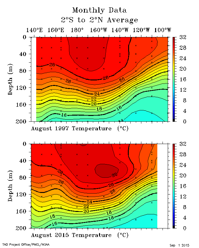
Eric Blake seems to be alluding to this El Nino potentially having a higher ceiling than 1997 due to the magnitude of warm subsurface water.

Eric Blake ‏@EricBlake12 4h4 hours ago
2015 does seem to have some warmer water at depth to potentially tap than 97 did- shud be an interesting fall #ElNino

Image
0 likes   
Contract Meteorologist. TAMU & MSST. Fiercely authentic, one of a kind. We are all given free will, so choose a life meant to be lived. We are the Masters of our own Stories.
Opinions expressed are mine alone.

Follow me on Twitter at @1900hurricane : Read blogs at https://1900hurricane.wordpress.com/

Iknownothing
Tropical Low
Tropical Low
Posts: 11
Joined: Sun Jul 21, 2013 12:05 pm

Re:

#6517 Postby Iknownothing » Tue Sep 01, 2015 3:59 pm

Ntxw wrote:SSH comparison between the two super Nino's of the past 20 years from Jason-2

Image


That comparison graphic has some very common characteristics. I don't know what it means but the most striking differences I see are the disconnect of the warm pool from South America in the 2015 graphic along with the much larger warm pool off the coast of Central America along with the West Coast
0 likes   

hcane27
Tropical Storm
Tropical Storm
Posts: 229
Joined: Tue Jan 31, 2006 7:33 pm

Re: Re:

#6518 Postby hcane27 » Tue Sep 01, 2015 4:26 pm

Iknownothing wrote:
Ntxw wrote:SSH comparison between the two super Nino's of the past 20 years from Jason-2

Image


That comparison graphic has some very common characteristics. I don't know what it means but the most striking differences I see are the disconnect of the warm pool from South America in the 2015 graphic along with the much larger warm pool off the coast of Central America along with the West Coast


and the far western Pacific is much cooler over a larger area
0 likes   

HURRICANELONNY
Category 5
Category 5
Posts: 1381
Joined: Wed May 07, 2003 6:48 am
Location: HOLLYWOOD.FL

#6519 Postby HURRICANELONNY » Tue Sep 01, 2015 5:37 pm

Why does tropical tidbit have 3.4 nino at 1.9 and cpc 2.2.

http://www.tropicaltidbits.com/analysis/nino34.png
0 likes   
hurricanelonny

Dean_175
Category 1
Category 1
Posts: 298
Joined: Mon Oct 17, 2011 1:34 pm

Re: Re:

#6520 Postby Dean_175 » Tue Sep 01, 2015 5:42 pm

Iknownothing wrote:
Ntxw wrote:SSH comparison between the two super Nino's of the past 20 years from Jason-2

Image


That comparison graphic has some very common characteristics. I don't know what it means but the most striking differences I see are the disconnect of the warm pool from South America in the 2015 graphic along with the much larger warm pool off the coast of Central America along with the West Coast


Those are Sea Surface Height(SSH) anomalies - not SST anomalies. The red/white is where the sea level height is increased- while the purple is where it has decreased. Sea surface height is one of a few ways to "see" equatorial waves and ENSO related displacement of the warm water layer. The others are isotherm depth anomalies and y-z subsurface temperature anomalies. Usually when the height is raised , the isotherms near the thermocline should be displaced downward - and the subsurface temps should be anomalously warm.

The "disconnect" of the SSH anomalies from the South American coast is causing us to have much cooler Nino1+2 temperatures than we saw in 1997. We are still seeing warm anomalies here but the warming is much more evenly distributed. In 1997, the large thermocline depth anomalies in the east effectively shut off the effect of upwelling of cooler water from below-causing 1+2 to become much warmer than average. The 1+2 region anomalies were so big in the 1997-1998 event that - despite this region having much cooler climatological average temperatures than 3.4- actually saw warmer total SSTs than the 3.4 region in early 1998.

The negative anomalies out in the west Pacific are due to the equatorial oceanic Rossby wave response. The wind stress forces warm water to slosh eastward as a "fast" Kelvin wave, but also produces a "slow" westward propagating equatorial Rossby wave response (along with the transfer of water away from the west equatorial Pacific). The Rossby waves straddle the equator- producing SSH anomalies on both sides.
Last edited by Dean_175 on Tue Sep 01, 2015 6:00 pm, edited 2 times in total.
0 likes   
All posts by Dean_175 are NOT official forecasts and should not be used as such. They are just the opinion of the poster and may or may not be backed by sound meteorological data. They are NOT endorsed by any professional institution or storm2k.org. For official information, please refer to the NHC and NWS products.


Return to “Talkin' Tropics”

Who is online

Users browsing this forum: Cpv17, cycloneye, Google Adsense [Bot], Hurricaneman, jlauderdal, Lizzytiz1, SFLcane, zzzh and 186 guests