I have a question though, and please reference my username if it seems like a dumb question. I Live in Socal and there's been a lot of talk about "the blob" of warmer than usual water off our coast and how storms might be less numerous with this El Nino because of it. However, I was wondering, due to the water being warmer, wouldn't storms this winter that did eventually track our way be slightly stronger than they would be normally from crossing over the warmer than usual water?
ENSO Updates (2007 thru 2023)
Moderator: S2k Moderators
Forum rules

The posts in this forum are NOT official forecasts and should not be used as such. They are just the opinion of the poster and may or may not be backed by sound meteorological data. They are NOT endorsed by any professional institution or STORM2K. For official information, please refer to products from the National Hurricane Center and National Weather Service.
-
Iknownothing
- Tropical Low

- Posts: 11
- Joined: Sun Jul 21, 2013 12:05 pm
Re: ENSO: July PDO is up to +1.84
I've been following this forum religiously for well over a year now. I've been attempting to register with no success until recently. Just wanted to say thank you to everyone who has been participating in this forum, I have learned so much just reading this topic.
I have a question though, and please reference my username if it seems like a dumb question. I Live in Socal and there's been a lot of talk about "the blob" of warmer than usual water off our coast and how storms might be less numerous with this El Nino because of it. However, I was wondering, due to the water being warmer, wouldn't storms this winter that did eventually track our way be slightly stronger than they would be normally from crossing over the warmer than usual water?

I have a question though, and please reference my username if it seems like a dumb question. I Live in Socal and there's been a lot of talk about "the blob" of warmer than usual water off our coast and how storms might be less numerous with this El Nino because of it. However, I was wondering, due to the water being warmer, wouldn't storms this winter that did eventually track our way be slightly stronger than they would be normally from crossing over the warmer than usual water?
0 likes

Re: ENSO: July PDO is up to +1.84
Iknownothing wrote:I've been following this forum religiously for well over a year now. I've been attempting to register with no success until recently. Just wanted to say thank you to everyone who has been participating in this forum, I have learned so much just reading this topic.
I have a question though, and please reference my username if it seems like a dumb question. I Live in Socal and there's been a lot of talk about "the blob" of warmer than usual water off our coast and how storms might be less numerous with this El Nino because of it. However, I was wondering, due to the water being warmer, wouldn't storms this winter that did eventually track our way be slightly stronger than they would be normally from crossing over the warmer than usual water?
This has been an ongoing debate between many about this El Nino and California drought relief. There is no definitive answer, however it is in the state's favor. Could it not produce like 1997? Sure but really an El Nino of this magnitude is something the state wants to see. The STJ will be active an eventually the Nino will dominate weather oscillations as winter comes as they usually do. Odds favor storms crashing into California, particularly the southern half more likely than not vs an average year.
And welcome to the board, glad you decided to join
0 likes
The above post and any post by Ntxw is NOT an official forecast and should not be used as such. It is just the opinion of the poster and may or may not be backed by sound meteorological data. It is NOT endorsed by any professional institution including Storm2k. For official information, please refer to NWS products.
Help support Storm2K!
-
Andrew92

- S2K Supporter

- Posts: 3247
- Age: 40
- Joined: Mon Jun 16, 2003 12:35 am
- Location: Phoenix, Arizona
I really hope California gets some of the kind of rain we've been getting in Arizona this monsoon season, but without the occasional damage we've had. Our monsoon season has been crazy this year! For the most part nothing major in the Phoenix area, but there was some damage at an airport in nearby Chandler and power outages in a recent storm.
Still, California really needs the extra rain that this El Nino hopefully promises for them this winter. As long as no damage comes with it, this will hopefully be good for them.
-Andrew92
Still, California really needs the extra rain that this El Nino hopefully promises for them this winter. As long as no damage comes with it, this will hopefully be good for them.
-Andrew92
0 likes
-
dexterlabio
- Category 5

- Posts: 3406
- Joined: Sat Oct 24, 2009 11:50 pm
Re: ENSO: July PDO is up to +1.84
As for that "warm blob", I guess that is susceptible to changes as we transition from summer to fall and from fall to winter... If I'm not mistaken 1997 also had that feature off the west coast of NA before transitioning to winter when El Nino reached its peak... I've been to San Francisco CA this summer and the drought has been terrible especially for the plantations. Never seen the mountains and fields in there as scorched. I do hope they will get much needed rain this year.
0 likes
Personal Forecast Disclaimer:
The posts in this forum are NOT official forecast and should not be used as such. They are just the opinion of the poster and may or may not be backed by sound meteorological data. They are NOT endorsed by any professional institution or storm2k.org. For official information, please refer to the NHC and NWS products.
The posts in this forum are NOT official forecast and should not be used as such. They are just the opinion of the poster and may or may not be backed by sound meteorological data. They are NOT endorsed by any professional institution or storm2k.org. For official information, please refer to the NHC and NWS products.
-
Iknownothing
- Tropical Low
- Posts: 11
- Joined: Sun Jul 21, 2013 12:05 pm
Re: ENSO: July PDO is up to +1.84
Thanks for the info guys! Either way I'm excited to see that were all but certainly going to have a much better winter this year here in Long Beach than the last few. And not to mention those large swells we get during El Nino. 
0 likes
-
Kingarabian

- S2K Supporter
- Posts: 15434
- Joined: Sat Aug 08, 2009 3:06 am
- Location: Honolulu, Hawaii
Re:
Kingarabian wrote:+2.0 tomorrow?
It will be close, though I have an inkling it may hold at 1.9C.
1997 achieves 2C at around the same update and will maintain that value or higher continuously for the next 6 months through mid February 1998.
0 likes
The above post and any post by Ntxw is NOT an official forecast and should not be used as such. It is just the opinion of the poster and may or may not be backed by sound meteorological data. It is NOT endorsed by any professional institution including Storm2k. For official information, please refer to NWS products.
Help support Storm2K!
Help support Storm2K!
-
Kingarabian
- S2K Supporter
- Posts: 15434
- Joined: Sat Aug 08, 2009 3:06 am
- Location: Honolulu, Hawaii
Re: Re:
Ntxw wrote:Kingarabian wrote:+2.0 tomorrow?
It will be close, though I have an inkling it may hold at 1.9C.
1997 achieves 2C at around the same update and will maintain that value or higher continuously for the next 6 months through mid February 1998.
Interesting.
Ntxw,
this post is from a user from Weatherunderground.com:

Is this the same WWB that is being talked about in previous recent posts or is this yet another new WWB?
0 likes
RIP Kobe Bryant
Its happened guys, this week's update will be 2C. First of its kind in 16 years. At least for the weekly updates, first 'super' reading. Its a big Nino.
0 likes
The above post and any post by Ntxw is NOT an official forecast and should not be used as such. It is just the opinion of the poster and may or may not be backed by sound meteorological data. It is NOT endorsed by any professional institution including Storm2k. For official information, please refer to NWS products.
Help support Storm2K!
Help support Storm2K!
-
xtyphooncyclonex

- Category 5
- Posts: 3688
- Age: 22
- Joined: Sat Dec 08, 2012 9:07 am
- Location: Cebu City
- Contact:
Now 2.0C as our Niño 3.4 reading, highest since Feb 11 1998
0 likes
REMINDER: My opinions that I, or any other NON Pro-Met in this forum, are unofficial. Please do not take my opinions as an official forecast and warning. I am NOT a meteorologist. Following my forecasts blindly may lead to false alarm, danger and risk if official forecasts from agencies are ignored.

Re:
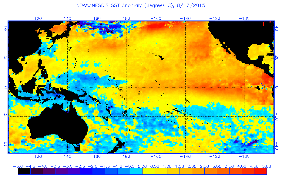
NDG wrote:Raging 2015/2016 El Nino. There's no turning back, LC has to have his head in a whole
http://www.ospo.noaa.gov/data/sst/anoma ... 7.2015.gif
He is the last holdout. Reading his weatheramerica blogs, it seems LC still doesn't believe this Nino has had profound effects on global weather and that it will rapidly weaken. Mentions this one is not in the likes of 1972, 1982, and 1997, I respectfully disagree with this thought. This week's reading will certainly put him back a few steps as this still has a way's to go. Peak will be in October, November, or December not June like his original thinking.
0 likes
The above post and any post by Ntxw is NOT an official forecast and should not be used as such. It is just the opinion of the poster and may or may not be backed by sound meteorological data. It is NOT endorsed by any professional institution including Storm2k. For official information, please refer to NWS products.
Help support Storm2K!
Help support Storm2K!
-
cycloneye

- Admin

- Posts: 139063
- Age: 67
- Joined: Thu Oct 10, 2002 10:54 am
- Location: San Juan, Puerto Rico
Re: ENSO:CPC 8/17/15 update=Nino 3.4 up to +2.0C
Text of weekly CPC update that has Nino 3.4 up to +2.0C.
http://www.cpc.ncep.noaa.gov/products/a ... ts-web.pdf
http://www.cpc.ncep.noaa.gov/products/a ... ts-web.pdf
0 likes
Visit the Caribbean-Central America Weather Thread where you can find at first post web cams,radars
and observations from Caribbean basin members Click Here
and observations from Caribbean basin members Click Here
Re: Re:
Ntxw wrote:NDG wrote:Raging 2015/2016 El Nino. There's no turning back, LC has to have his head in a whole
http://www.ospo.noaa.gov/data/sst/anoma ... 7.2015.gif
He is the last holdout. Reading his weatheramerica blogs, it seems LC still doesn't believe this Nino has had profound effects on global weather and that it will rapidly weaken. Mentions this one is not in the likes of 1972, 1982, and 1997, I respectfully disagree with this thought. This week's reading will certainly put him back a few steps as this still has a way's to go. Peak will be in October, November, or December not June like his original thinking.
He has gone insane, is all I have to say lol.
0 likes
Re: ENSO:CPC 8/17/15 update=Nino 3.4 up to +2.0C
The Euro weeklies, which are issued twice/week during the evening, are out for today. They show the warmest 2M anomalies remain near 120W through all four weeks, implying the warmest SST anomalies being there (central or east-central based El Nino).
0 likes
Personal Forecast Disclaimer:
The posts in this forum are NOT official forecasts and should not be used as such. They are just the opinion of the poster and may or may not be backed by sound meteorological data. They are NOT endorsed by any professional institution or storm2k.org. For official information, please refer to the NHC and NWS products.
The posts in this forum are NOT official forecasts and should not be used as such. They are just the opinion of the poster and may or may not be backed by sound meteorological data. They are NOT endorsed by any professional institution or storm2k.org. For official information, please refer to the NHC and NWS products.
Another westerly wind burst is on the way east of the dateline. Will it become a major WWB? The last westerly burst the GFS botched it, ended up a major one vs just a small fan on the water in real time vs forecast. I bet it will be as just a few days ago it didn't have much to start with.

0 likes
The above post and any post by Ntxw is NOT an official forecast and should not be used as such. It is just the opinion of the poster and may or may not be backed by sound meteorological data. It is NOT endorsed by any professional institution including Storm2k. For official information, please refer to NWS products.
Help support Storm2K!
Help support Storm2K!
Per Mike Ventrice, 4.11 sigma atmospheric index (this is not used by the CPC just his company) would be the highest since 1983 (record) and will go towards 4.3+ sigma. If you're just comparing apples to apples of this year's Nino vs the previous via the same index then might be helpful. Ocean wise though still got a way's to go to beat 1982.

0 likes
The above post and any post by Ntxw is NOT an official forecast and should not be used as such. It is just the opinion of the poster and may or may not be backed by sound meteorological data. It is NOT endorsed by any professional institution including Storm2k. For official information, please refer to NWS products.
Help support Storm2K!
Help support Storm2K!

Re: ENSO Updates
This is what a strong nino does to the West Pacific, the most active basin in the world...
http://rammb.cira.colostate.edu/ramsdis/online/loop.asp?data_folder=himawari-8/full_disk_ahi_true_color&width=800&height=800&number_of_images_to_display=60&loop_speed_ms=100
http://rammb.cira.colostate.edu/ramsdis/online/loop.asp?data_folder=himawari-8/full_disk_ahi_true_color&width=800&height=800&number_of_images_to_display=60&loop_speed_ms=100
0 likes
Remember, all of my post aren't official. For official warnings and discussions, Please refer to your local NWS products...
NWS for the Western Pacific
https://www.weather.gov/gum/
NWS for the Western Pacific
https://www.weather.gov/gum/
-
cycloneye
- Admin
- Posts: 139063
- Age: 67
- Joined: Thu Oct 10, 2002 10:54 am
- Location: San Juan, Puerto Rico
Re: ENSO Updates
The Mid-August plume of ENSO models have the peak around December,January and Febuary.
http://iri.columbia.edu/our-expertise/c ... -sst_table
http://iri.columbia.edu/our-expertise/c ... -sst_table
0 likes
Visit the Caribbean-Central America Weather Thread where you can find at first post web cams,radars
and observations from Caribbean basin members Click Here
and observations from Caribbean basin members Click Here
0 likes
The above post and any post by Ntxw is NOT an official forecast and should not be used as such. It is just the opinion of the poster and may or may not be backed by sound meteorological data. It is NOT endorsed by any professional institution including Storm2k. For official information, please refer to NWS products.
Help support Storm2K!
Help support Storm2K!
Who is online
Users browsing this forum: BlueWater36, cycloneye, Google Adsense [Bot], JetFuel_SE, South Texas Storms, Teban54, tolakram and 211 guests