ENSO Updates (2007 thru 2023)

This is the general tropical discussion area. Anyone can take their shot at predicting a storms path.

Moderator: S2k Moderators

Forum rules

The posts in this forum are NOT official forecasts and should not be used as such. They are just the opinion of the poster and may or may not be backed by sound meteorological data. They are NOT endorsed by any professional institution or STORM2K. For official information, please refer to products from the National Hurricane Center and National Weather Service.

Help Support Storm2K
Message
Author
dexterlabio
Category 5
Category 5
Posts: 3406
Joined: Sat Oct 24, 2009 11:50 pm

Re: CPC 11/16/15: Nino 3.4 up to +3.0C / Surpassed 1997

#6741 Postby dexterlabio » Wed Nov 18, 2015 2:38 am

Dean_175 wrote:^^ MJO is probably the main reason SOI has risen. It's partially cancelling the El Nino's influence on SOI temporarily. SOI will likely drop again and could reach its lowest value sometime this winter after the peak(which I feel that you are correct in saying it has/is come, at least in terms of OISST weeklies). But many Ninos don't have the strongest SOI until later. In fact the most strongly negative SOI during the 1997 El Nino was not until March 1998, well after the peak.Not 100 percent sure why, but it could have to do with the fact that as the south Pacific warms seasonally from November through March, the effect on the atmosphere from ENSO shifts and changes.


Same as the 2009-2010 El Nino...the lowest SOI reading for that episode was recorded past its peak..
0 likes   
Personal Forecast Disclaimer:
The posts in this forum are NOT official forecast and should not be used as such. They are just the opinion of the poster and may or may not be backed by sound meteorological data. They are NOT endorsed by any professional institution or storm2k.org. For official information, please refer to the NHC and NWS products.

User avatar
cycloneye
Admin
Admin
Posts: 139067
Age: 67
Joined: Thu Oct 10, 2002 10:54 am
Location: San Juan, Puerto Rico

Re: CPC 11/16/15: Nino 3.4 up to +3.0C / Surpassed 1997

#6742 Postby cycloneye » Wed Nov 18, 2015 2:37 pm

Let's see how it all unfolds.

Ryan Maue ‏@RyanMaue · 17m17 minutes ago
Unless 2015 El Nino part of some undiagnosed or unpredicted climate shift, tropical Pacific & globe should cool into potential 2016 La Nina
0 likes   
Visit the Caribbean-Central America Weather Thread where you can find at first post web cams,radars
and observations from Caribbean basin members Click Here

User avatar
Hurricaneman
Category 5
Category 5
Posts: 7281
Age: 43
Joined: Tue Aug 31, 2004 3:24 pm
Location: central florida

#6743 Postby Hurricaneman » Wed Nov 18, 2015 2:49 pm

ENSO 1\2 is tanking and even a little fall in the eastern end of 3, still rising in 3 overall though but the 3\4 is still rising and 4 is pretty steady so I don't know whats going to happen but it seems as though without WWBs a general drop in the 1\2 region while 3\4 remains steady at 3.0+ until at least mid December

The posts in this forum are NOT official forecast and should not be used as such. They are just the opinion of the poster and may or may not be backed by sound meteorological data. They are NOT endorsed by any professional institution or storm2k.org. For official information, please refer to the NHC and NWS products
0 likes   

User avatar
cycloneye
Admin
Admin
Posts: 139067
Age: 67
Joined: Thu Oct 10, 2002 10:54 am
Location: San Juan, Puerto Rico

Re: CPC 11/16/15: Nino 3.4 up to +3.0C / Surpassed 1997

#6744 Postby cycloneye » Thu Nov 19, 2015 3:41 pm

The Mid-November plume of ENSO models continue to go with the El Nino crash by next Spring and the question is if we will see La Nina or it will be Neutral by the Summer.

Image
0 likes   
Visit the Caribbean-Central America Weather Thread where you can find at first post web cams,radars
and observations from Caribbean basin members Click Here

User avatar
Hurricaneman
Category 5
Category 5
Posts: 7281
Age: 43
Joined: Tue Aug 31, 2004 3:24 pm
Location: central florida

#6745 Postby Hurricaneman » Thu Nov 19, 2015 5:57 pm

Looks to be steadying out at +3.0
0 likes   

Dean_175
Category 1
Category 1
Posts: 297
Joined: Mon Oct 17, 2011 1:34 pm

Re: ENSO Updates

#6746 Postby Dean_175 » Sat Nov 21, 2015 1:14 pm

Negative sea level/depth anomalies have now spread east of the dateline. There will be more significant negative anomalies to come as more equatorial Rossby wave energy is reflected as upwelling Kelvin waves.
Right now, there is still plenty of westerly wind anomalies to keep the thermocline deep in the east and central Pacific. But by January, the westerly anomalies will move south of the equator as the southern central and western Pacific warms seasonally. Example from 1998:
Image


This will cause the thermocline to rise in the east and the negative depth anomalies to extend to the eastern Pacific---at that time the SST will start to drop off rapidly.

CFS is showing the positive sea level anomalies to almost completely go away by February, and be replaced with significant negative anomalies by summer. I think that there is a good chance of La Nina or at least cool neutral developing by late next year.
0 likes   
All posts by Dean_175 are NOT official forecasts and should not be used as such. They are just the opinion of the poster and may or may not be backed by sound meteorological data. They are NOT endorsed by any professional institution or storm2k.org. For official information, please refer to the NHC and NWS products.

Ntxw
Storm2k Moderator
Storm2k Moderator
Posts: 21501
Joined: Wed Oct 21, 2009 6:34 pm
Location: DFW, Texas

#6747 Postby Ntxw » Sat Nov 21, 2015 7:22 pm

It will still take many months, remember nothing in ENSO happens rapidly (relatively speaking). Per say if peak is now it will still have weekly readings of 2C through December and possibly early Jan. It will hold strong status through most of winter and moderate by Spring. CFS is declining fast by slope but that slope is still seen in months not weeks. This El Nino won't officially 'end' until the last 0.5C reading which wont happen until May or June which is 7 months away. But after that we should be in neutral status and by early spring we will have a good idea if/when the Nina will come.
0 likes   
The above post and any post by Ntxw is NOT an official forecast and should not be used as such. It is just the opinion of the poster and may or may not be backed by sound meteorological data. It is NOT endorsed by any professional institution including Storm2k. For official information, please refer to NWS products.

  Help support Storm2K!
Help Support Storm2K

WeatherGuesser
Category 5
Category 5
Posts: 2672
Joined: Tue Jun 29, 2010 6:46 am

#6748 Postby WeatherGuesser » Mon Nov 23, 2015 5:48 am

Page with lots of words and maps that basically says 'if you want to know how this all affects our Winter '15-'16, come back in April and ask us then 'cuz it could go either way'.

http://www.weather.gov/pah/ElNinoImpactsOnWinterWeather
0 likes   

Ntxw
Storm2k Moderator
Storm2k Moderator
Posts: 21501
Joined: Wed Oct 21, 2009 6:34 pm
Location: DFW, Texas

#6749 Postby Ntxw » Mon Nov 23, 2015 7:52 am

3.1C this week
0 likes   
The above post and any post by Ntxw is NOT an official forecast and should not be used as such. It is just the opinion of the poster and may or may not be backed by sound meteorological data. It is NOT endorsed by any professional institution including Storm2k. For official information, please refer to NWS products.


  Help support Storm2K!

Help Support Storm2K


User avatar
NDG
S2K Supporter
S2K Supporter
Posts: 14933
Joined: Sun Jul 09, 2006 10:14 pm
Location: Orlando, FL

Re: ENSO Updates

#6750 Postby NDG » Mon Nov 23, 2015 8:45 am

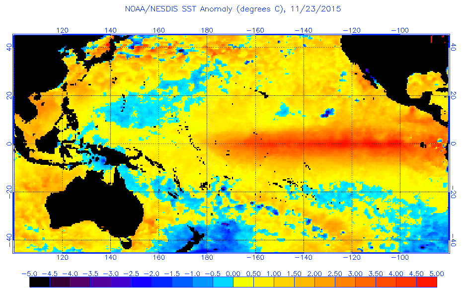
So how will this affect southern California, is all I want to know. So far most of the rains that have fallen this Fall so far has been north of southern Cal, probably more than forecasted for the Pacific NW.
Nino 1+2 is indeed cooler than '97 but this is no true Modoki either.

Image
0 likes   

Ntxw
Storm2k Moderator
Storm2k Moderator
Posts: 21501
Joined: Wed Oct 21, 2009 6:34 pm
Location: DFW, Texas

#6751 Postby Ntxw » Mon Nov 23, 2015 8:52 am

:uarrow: There will be some good rains in northern California and the high Sierras next 7 days. A little rain for parts of SoCal, I'm not sure on their climo to see if that is anomalous or not
0 likes   
The above post and any post by Ntxw is NOT an official forecast and should not be used as such. It is just the opinion of the poster and may or may not be backed by sound meteorological data. It is NOT endorsed by any professional institution including Storm2k. For official information, please refer to NWS products.


  Help support Storm2K!

Help Support Storm2K


Ntxw
Storm2k Moderator
Storm2k Moderator
Posts: 21501
Joined: Wed Oct 21, 2009 6:34 pm
Location: DFW, Texas

Re: ENSO Updates

#6752 Postby Ntxw » Mon Nov 23, 2015 9:00 am

NDG wrote:Nino 1+2 is indeed cooler than '97 but this is no true Modoki either.


I did find this quote interesting and going through AHPS rainfall data from NOAA for the year. 1997 type warmth where it hugs the south american coast has most anomalous rains in the southwest, modoki in the southeast US. 2015 has centered in the plains right in the middle, particularly the southern plains.

Image
0 likes   
The above post and any post by Ntxw is NOT an official forecast and should not be used as such. It is just the opinion of the poster and may or may not be backed by sound meteorological data. It is NOT endorsed by any professional institution including Storm2k. For official information, please refer to NWS products.


  Help support Storm2K!

Help Support Storm2K


User avatar
NDG
S2K Supporter
S2K Supporter
Posts: 14933
Joined: Sun Jul 09, 2006 10:14 pm
Location: Orlando, FL

Re:

#6753 Postby NDG » Mon Nov 23, 2015 9:17 am

Ntxw wrote::uarrow: There will be some good rains in northern California and the high Sierras next 7 days. A little rain for parts of SoCal, I'm not sure on their climo to see if that is anomalous or not


I just looked really quick, compared to '97 so far this November the Pacific NW has been much wetter while southern California has had a drier month than that year.
0 likes   

Ntxw
Storm2k Moderator
Storm2k Moderator
Posts: 21501
Joined: Wed Oct 21, 2009 6:34 pm
Location: DFW, Texas

Re: Re:

#6754 Postby Ntxw » Mon Nov 23, 2015 9:19 am

NDG wrote:I just looked really quick, compared to '97 so far this November the Pacific NW has been much wetter while southern California has had a drier month than that year.


A lot of that has to do with the MJO I think. It's been anti Nino since late October, reflecting in the SOI. There should be a SOI crash in the coming weeks and the MJO fading. Lets see if the Nino reverts back to background influence, if it doesn't then probably something else is at play.
0 likes   
The above post and any post by Ntxw is NOT an official forecast and should not be used as such. It is just the opinion of the poster and may or may not be backed by sound meteorological data. It is NOT endorsed by any professional institution including Storm2k. For official information, please refer to NWS products.


  Help support Storm2K!

Help Support Storm2K


User avatar
cycloneye
Admin
Admin
Posts: 139067
Age: 67
Joined: Thu Oct 10, 2002 10:54 am
Location: San Juan, Puerto Rico

Re: ENSO Updates

#6755 Postby cycloneye » Mon Nov 23, 2015 10:32 am

El Nino of 2015 keeps creeping up now at +3.1C

http://www.cpc.ncep.noaa.gov/products/a ... ts-web.pdf
0 likes   
Visit the Caribbean-Central America Weather Thread where you can find at first post web cams,radars
and observations from Caribbean basin members Click Here

curtadams
S2K Supporter
S2K Supporter
Posts: 1118
Joined: Sun Aug 28, 2005 7:57 pm
Location: Orange, California
Contact:

Re: Re:

#6756 Postby curtadams » Mon Nov 23, 2015 12:46 pm

NDG wrote:I just looked really quick, compared to '97 so far this November the Pacific NW has been much wetter while southern California has had a drier month than that year.


82 would be a closer comparison, as the heat distribution is more like that super El Nino than 97. 82 had a more gradual run-up than 97 as well, although less so than 15.
0 likes   

User avatar
cycloneye
Admin
Admin
Posts: 139067
Age: 67
Joined: Thu Oct 10, 2002 10:54 am
Location: San Juan, Puerto Rico

#6757 Postby cycloneye » Wed Nov 25, 2015 7:16 am

Joe Bastardi ‏@BigJoeBastardi · 5m5 minutes ago  State College, PA
SOI rise to continue next week, but look out Crash coming late next week and cattle prod to pattern starts Wild Dec 15-25 US!
0 likes   
Visit the Caribbean-Central America Weather Thread where you can find at first post web cams,radars
and observations from Caribbean basin members Click Here

Alyono
Professional-Met
Professional-Met
Posts: 6961
Joined: Fri Apr 26, 2013 3:52 pm
Location: Texas Coast

#6758 Postby Alyono » Wed Nov 25, 2015 7:51 pm

Reminders about next year:

1. Some of the models still show an el nino. Neutral or nina is not guaranteed.

2. If the pdo is highly positive and ssts stay boiling just north of the equator, its 1983 all over again. Dont only pay attention to the equator. Look at the whole tropical pacific. Im thinking the epac will again be the hot spot next year
0 likes   

User avatar
WPBWeather
S2K Supporter
S2K Supporter
Posts: 535
Age: 65
Joined: Thu Jul 18, 2013 12:33 pm

Re:

#6759 Postby WPBWeather » Wed Nov 25, 2015 8:39 pm

Alyono wrote:Reminders about next year:

1. Some of the models still show an el nino. Neutral or nina is not guaranteed.

2. If the pdo is highly positive and ssts stay boiling just north of the equator, its 1983 all over again. Dont only pay attention to the equator. Look at the whole tropical pacific. Im thinking the epac will again be the hot spot next year


Actually, the hurricanes in groups article I posted earlier this season seems to be gaining more credence in the scientific community. And I'll bet the ATL will be more active than many believe. Just an opinion about the ATL but the hurricanes in groups is not my idea, but makes sense after seeing 2004-5.
0 likes   

User avatar
Kingarabian
S2K Supporter
S2K Supporter
Posts: 15434
Joined: Sat Aug 08, 2009 3:06 am
Location: Honolulu, Hawaii

Re: Re:

#6760 Postby Kingarabian » Wed Nov 25, 2015 8:45 pm

WPBWeather wrote:
Alyono wrote:Reminders about next year:

1. Some of the models still show an el nino. Neutral or nina is not guaranteed.

2. If the pdo is highly positive and ssts stay boiling just north of the equator, its 1983 all over again. Dont only pay attention to the equator. Look at the whole tropical pacific. Im thinking the epac will again be the hot spot next year


Actually, the hurricanes in groups article I posted earlier this season seems to be gaining more credence in the scientific community. And I'll bet the ATL will be more active than many believe. Just an opinion about the ATL but the hurricanes in groups is not my idea, but makes sense after seeing 2004-5.


It's going to be tough to make a prediction for any basin next year at this time. Just going to have sit back and wait until February.
0 likes   
RIP Kobe Bryant


Return to “Talkin' Tropics”

Who is online

Users browsing this forum: chaser1, Old-TimeCane and 205 guests