gigabite wrote: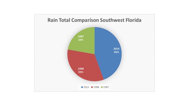
Well for the past 6 months it looks more like 1998.
Can you share the source where the chart comes from?
I thought you were talking about the month of October so far or at least Sep-Oct time frame.
Edit:I went back into climate history for your area and this is what I found:
Yes, the summer of '97 was a much drier than average summer for your area compared to this year, and even compared to '98, but keep in mind that El Nino & its effects appeared much sooner this year than in '97. Summer of '97 had a total rainfall deficit of -12.4"
This year it helped that there was a semi-permanent subtropical jet trough over the GOM that helped enhanced convection in this area.
Summer of '98 was actually drier than normal during June, July & August with a total deficit for those 3 months of almost - 8.0"
Because of tropical activity in Sept '98 you guys had a surplus for that month of nearly + 3", and also because of Hurricane Mitch in Nov '98 you guys ended up with a surplus of + 4.5" for that month.
This is the difference during the late Fall into early Spring months between a strong El Nino year and a typical La Nina year:Dec '97-March '98 you guys ended up with a surplus of around 8" during those months, a very wet period.
Dec '98-March '99 you guys ended up with a deficit of - 3.2"


