Overall shear looks to be lower then normal...The tutt is centered near 55-60 with main area of shear around 48-55 west, at between 30-50 mph. Also the gulf of mexico has 30-50 knot shear to, mainly to the northwestern gulf. While the Caribbean and Eastern Atlatnic is very favorble shear wise. On norm the overall strength of the frontal system decreases as you get into July,August. So overall shear through out the gulf of Mexico should go down. Also tutt should weaken to 25-30 knots by August; this is my thoughts. So overall upper level shear looks to be very favorable this year. In fact the eastern Pacific looks to be super favorable at 5-10 knots over most of the area. Yes there will be systems(extratropical) "ulls" and frontal systems through out the next few months. But overall much more favorable then you would expect.
http://www.ssd.noaa.gov/PS/TROP/DATA/gparm/xyrshr.gif
This shows how much lower the overall shear is...Notice that much of the northern Gulf of Mexico is 5-15 knots higher on normal. With the tutt shfited at least 5-8 degrees eastward, so far this year. Eastern Atlatnic is the most noteable of the area's. With 25-30 knot below avg shear over the Cape verdes. Remember this changes daily...
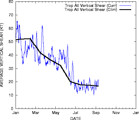
Also upper level shear over the tropical Atlatnic 8-10 knots below avg.
http://www.ssd.noaa.gov/PS/TROP/DATA/gparm/tatshr.gif
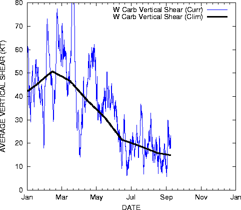
Western Caribbean is down to 10 knots over the last week. Normally 20-25 knots on avg.
http://www.ssd.noaa.gov/PS/TROP/DATA/gparm/wcashr.gif
The Gulf of Mexico and Eastern Caribbean have been close to Avg. East coast has droped 5 knots below avg. So overall less shear then normal.
Here is the cimiss shear map.
http://cimss.ssec.wisc.edu/tropic/real- ... g8shr.html
SAL is very unfavorable for the eastern Atlantic. So this is the one thing keeping things from forming over the East Atlantic.
http://cimss.ssec.wisc.edu/tropic/real- ... split.html While the Caribbean/Western Atlatnic/Gulf looks almost free of it. http://cimss.ssec.wisc.edu/tropic/real- ... kAsal.html
So overall things over the Caribbean look very favorable. The western Atlantic and Eastern Gulf of Mexico is below Avg sst's. While the tropical Atlantic is near normal, Caribbean is above. With some hint of La nina, expect overall shear to remain 5-10 knots lower over the tropical Atlantic this year. Also the Atlantic is running a month and a half ahead this year with overall Favorable.
The following post is NOT an official forecast and should not be used as such. It is just the opinion of the poster and may or may not be backed by sound meteorological data. It is NOT endorsed by any professional institution or storm2k.org. For official information, please refer to the NHC and NWS products.
Atlantic looks very favorable
Moderator: S2k Moderators
Forum rules

The posts in this forum are NOT official forecasts and should not be used as such. They are just the opinion of the poster and may or may not be backed by sound meteorological data. They are NOT endorsed by any professional institution or STORM2K. For official information, please refer to products from the National Hurricane Center and National Weather Service.
-
Weatherfreak000
Definitely agreeing with this logic, and the persistence of the lows has been downright phenomenal thus far this year.
The one thing that could put a damper on this is the definitely below average SST's this year. The GOM isn't looking to hot and compared to 2005/2006's standards the Caribbean and East Atlantic isn't either.
This definitely seems to conclude less powerful storms as the loop current this year is no where near as warm as 2005/2006. That's a blessing enough as it is, so knowing this I am fairly content with a 18 storm year this year. And with our current dynamics it seems quite possible.
(That last paragraph isn't meant to be taken presumptuous or wishful)
0 likes
-
windstorm99

- S2K Supporter

- Posts: 1578
- Age: 48
- Joined: Sat May 26, 2007 8:10 am
- Location: Miami, Florida
- Contact:

-
Matt-hurricanewatcher
I agree the sst's are going to keep this season in check. Also the Western Atlantic is .5-2.0f below normal overall. With the tropical Atlantic coolest since 2002...I expect two things to happen; 1# the tropical waves will turn northward faster this year, because of the tutt at upper level are east of it normally is. Also the lower level 850 has a gap near 55-60 west...So systems that do develop fast should turn out to sea, at least over the next month or two. Later on this season that could change. 2# Tropical waves could be checked because of the cooler sst's, so they move into the caribbean like Charley ect. Which case they become powerful systems tracking across the Caribbean.
Overall there is more troughing over the western Gulf of Mexico. Which tells me there is more overall troughing over central United states. So systems are going to be like Charley,Ivan,Alberto,Arlene,...Not saying we will get those kind of storms. But saying that the track will favor a westward track through the caribbean, fellowed by a northward or northeast as they get into the Gulf. At least into mid August. We will see what happens. Yeah I do think a lot of our storms will be close to land.
Also to add, I don't expect a Katrina,Rita, or even Ivan to hit the northern Gulf. Why because of the cooler sst's over the gulf. Do I expect powerful storms over the Caribbean and maybe a few in the central Atlatnic. I think its very possible.
0 likes
-
windstorm99
- S2K Supporter
- Posts: 1578
- Age: 48
- Joined: Sat May 26, 2007 8:10 am
- Location: Miami, Florida
- Contact:
Yea for the past month one or so we have had persistent trofiness in place which would be great news if this were to continue threw the heart of the season.I think an overall an active season numbers wise seems like a good bet but we could be in good shape if the steering currrents are your friend.The bermuda high is in its normal location and really as of now i dont see any similarities to 2004-2005 in regards to the pattern.We'll see how everything evolves in the coming months.
It's all about timeing with tropical systems.
www.Adrian's Weather.com
It's all about timeing with tropical systems.
www.Adrian's Weather.com
0 likes

-
HurricaneHunter914
- Category 5

- Posts: 4439
- Age: 32
- Joined: Fri Mar 10, 2006 7:36 pm
- Location: College Station, TX
Matt-hurricanewatcher wrote:I agree the sst's are going to keep this season in check. Also the Western Atlantic is .5-2.0f below normal overall. With the tropical Atlantic coolest since 2002...I expect two things to happen; 1# the tropical waves will turn northward faster this year, because of the tutt at upper level are east of it normally is. Also the lower level 850 has a gap near 55-60 west...So systems that do develop fast should turn out to sea, at least over the next month or two. Later on this season that could change. 2# Tropical waves could be checked because of the cooler sst's, so they move into the caribbean like Charley ect. Which case they become powerful systems tracking across the Caribbean.
Overall there is more troughing over the western Gulf of Mexico. Which tells me there is more overall troughing over central United states. So systems are going to be like Charley,Ivan,Alberto,Arlene,...Not saying we will get those kind of storms. But saying that the track will favor a westward track through the caribbean, fellowed by a northward or northeast as they get into the Gulf. At least into mid August. We will see what happens. Yeah I do think a lot of our storms will be close to land.
Also to add, I don't expect a Katrina,Rita, or even Ivan to hit the northern Gulf. Why because of the cooler sst's over the gulf. Do I expect powerful storms over the Caribbean and maybe a few in the central Atlatnic. I think its very possible.
If those curving storms stay weak, they'll be more of a blessing to the SE Coast than a curse.
0 likes
I agree with x-y-no, the SSTs have been held in check due to eastern troughs and Atlantic high pressure that have kept a NE wind flow across the SE US and unusually cool June across parts of the southeast and GOM. Since Barry has passed the pattern has quickly shifted into the typical summer-like pattern. You will see SSTs begin to climb to seasonal norms. I don't see this as a surpressing factor as we get into July 
0 likes
-
gatorcane

- S2K Supporter
- Posts: 23703
- Age: 47
- Joined: Sun Mar 13, 2005 3:54 pm
- Location: Boca Raton, FL
x-y-no wrote:Sure there's a substantial cool anomaly north of 21N between Florida and about 60W, but the Caribbean and the MDR are still warmer than average, so I wouldn't count on SSTs suppressing development.
The mean position of the ridge, OTOH ...
I agree with Jan, don't count on SSTs in the Caribbean and GOM to be low enough to "suppress" major hurricanes. The SSTs in this region are ALWAYS warm enough come Aug - Oct.
0 likes
-
Matt-hurricanewatcher
2006
Tropical Atlantic-Near normal or slightly below(-5 knots) June-October.
http://rammb.cira.colostate.edu/project ... tatshr.gif
Western Caribbean-near Normal or slight below June-October time frame.
http://rammb.cira.colostate.edu/project ... wcashr.gif
Eastern Caribbean-Near normal over all June to October period. Highs and lows.
http://rammb.cira.colostate.edu/project ... ecashr.gif
Gulf of Mexico-Near normal
http://rammb.cira.colostate.edu/project ... gmxshr.gif
East coast near normal.
http://rammb.cira.colostate.edu/project ... ecoshr.gif
Subtropics-Near normal.
http://rammb.cira.colostate.edu/project ... satshr.gif
Overall 2006 Atlatnic was near or slightly below normal wind shear...Of around 5 knots or so. I'm thinking that overall it was the SAL/dry air that helped kill last season. Which put a cap on convection formation...In had a large part in killing all the tropical waves...Also 2006 was near normal, so maybe it was just fellowing the norm. We will see what happens in 2007, with the "la nina".
Here is 2005...
Tropical Atlatnic
http://rammb.cira.colostate.edu/project ... hr2005.gif
Western Caribbean
http://rammb.cira.colostate.edu/project ... hr2005.gif
As you can see the overall shear is at least 5-10 knots below the norm.
http://rammb.cira.colostate.edu/project ... hr2005.gif
http://rammb.cira.colostate.edu/project ... hr2005.gif
http://rammb.cira.colostate.edu/project ... hr2005.gif
http://rammb.cira.colostate.edu/project ... hr2005.gif
So the differences between 2005-2006 "could" be less then 5-10 knots of shear. Also there is other factors. Including less SAL/dry air, less eastly shear, more heat to form convection=storms meaning warmer sst's or tchp.
As of right now the Atlantic looks a little less favorable. But we need to keep watching for that to change.
0 likes

Who is online
Users browsing this forum: No registered users and 102 guests