Was Hurricane Andrew Close to Being Annular?

If you have a question, don't care what it is ~ If you need a hand, We can assure you this ~ We can help

Moderator: S2k Moderators

Message
Author
User avatar
Cyclenall
Category 5
Category 5
Posts: 6627
Joined: Thu Jun 08, 2006 10:01 pm
Location: Ontario, Canada

Was Hurricane Andrew Close to Being Annular?

#1 Postby Cyclenall » Tue Jul 21, 2009 11:25 pm

Before this gets any heat, let me explain what I'm getting at. I was browsing some imagery on a weather site I just found and it happened to have some strange IR archived images for Hurricane Andrew and other products like floaters. I was viewing some for early August 24 just before Andrew made landfall and interestingly enough:

Image

Image

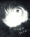
Seems like there aren't any rain bands. At 6:00 UTC, Andrew looks like a perfect circle. Could this mean Andrew was close to being an annular storm? This might help explain why it behaved like it did (not weakening very much during passage, mini swirls occurring within eyewall, etc.) Keep in mind Hurricane Carlos was called an annular hurricane by the NHC when it didn't look like one, Hurricane Andrew looked way more so than Carlos ever did IMO. There is so much talk over this hurricane so it's puzzling as to why it's never been brought up before.
0 likes   

User avatar
theavocado
Professional-Met
Professional-Met
Posts: 162
Age: 47
Joined: Sun Mar 22, 2009 8:54 pm
Location: NOLA

Re: Was Hurricane Andrew Close to Being Annular?

#2 Postby theavocado » Fri Jul 24, 2009 1:51 pm

I think a lot of what you are seeing is the enchancement curve applied to that IR image set. Below is a time sequence of visible imagery and you can clearly see the convective banding in the storm. The first position, east of Florida, is from the 23rd at 12UTC. So, about 15 and 18 hours before the images you posted. Between that time and landfall, Andrew underwent an ERC which might explain the funky eye shape/size seen in your images. It's a good thought, and I agree that Carlos looked way worse, but I thik the nature of storms this large is they are no longer connected to outside atmospheric features and tend to look more "cut off" than they are.

Image

Image courtesy of NASA.

http://rsd.gsfc.nasa.gov/rsd/images/andrew.html
0 likes   

User avatar
Cyclenall
Category 5
Category 5
Posts: 6627
Joined: Thu Jun 08, 2006 10:01 pm
Location: Ontario, Canada

Re: Was Hurricane Andrew Close to Being Annular?

#3 Postby Cyclenall » Fri Jul 24, 2009 5:16 pm

theavocado wrote:I think a lot of what you are seeing is the enchancement curve applied to that IR image set.

It's possible but I also notice this on satellite imagery.

theavocado wrote:Below is a time sequence of visible imagery and you can clearly see the convective banding in the storm. The first position, east of Florida, is from the 23rd at 12UTC. So, about 15 and 18 hours before the images you posted. Between that time and landfall, Andrew underwent an ERC which might explain the funky eye shape/size seen in your images.

Hurricane Andrew wasn't going through any ERC during that time, nothing about that in the NHC's official report. Is that your opinion or did you get that from somewhere else? The temporary weakening occurred just after those images when it has moving over the Great Bahama Bank.

theavocado wrote:It's a good thought, and I agree that Carlos looked way worse, but I thik the nature of storms this large is they are no longer connected to outside atmospheric features and tend to look more "cut off" than they are.

You mean storms this small (or synoptically?). It is possible it looked like that because of the high pressure history.
0 likes   

User avatar
theavocado
Professional-Met
Professional-Met
Posts: 162
Age: 47
Joined: Sun Mar 22, 2009 8:54 pm
Location: NOLA

Re: Was Hurricane Andrew Close to Being Annular?

#4 Postby theavocado » Fri Jul 24, 2009 5:43 pm

Cyclenall wrote: Hurricane Andrew wasn't going through any ERC during that time, nothing about that in the NHC's official report. Is that your opinion or did you get that from somewhere else? The temporary weakening occurred just after those images when it has moving over the Great Bahama Bank.


ZCZC MIATCDAT4
TTAA00 KNHC 240321 COR
...FOR INTERGOVERNMENTAL USE ONLY...
HURRICANE ANDREW DISCUSSION NUMBER 31
NATIONAL WEATHER SERVICE MIAMI FL
11 PM EDT SUN AUG 23 1992


...CORRECTED TO SHOW NEWER RECON PRESSURE OF 937 MB...


THERE ARE NO SIGNIFIGANT CHANGES TO REPORT IN EITHER THE TRACK OR
INTENSITY OF ANDREW. HOWEVER...MINOR STRUCTURAL EVOLUTION IS
UNDERWAY IN THE CORE REGION WITH RECON CONTINUING TO REPORT A
CONCENTRIC EYEWALL STRUCTURE. THIS DEVELOPMENT COINCIDES WITH A
SLIGHT DECREASE IN THE STRENGTH OF THE INTERIOR EYEWALL
...AND SO THE
INTENSITY HAS BEEN LOWERED A LITTLE...TO 120 KT. THIS IS ALSO
CONSISTENT WITH THE LAST RECON FIX OF 937 MB. NEVERTHELESS...THE
HURRICANE WILL BE PASSING SOON OVER THE WARM GULF STREAM WATERS SO
NOT MUCH ADDITIONAL WEAKENING IS EXPECTED...AND SOME RESTRENGHTENING
REMAINS POSSIBLE AS WELL.

THE TRACK FORECAST IS NEARLY IDENTICAL TO THE PREVIOUS COURSE.
LANDFALL IN THE MIAMI AREA AS A CATEGORY 4 HURRICANE AROUND 1200 UTC
IS BECOMING INCREASINGLY LIKELY. THE HURRICANE IS STILL EXPECTED TO
WEAKEN A LITTLE IN ITS TRANSIT OVER THE FLORIDA PENINSULA. THE 72
HOUR POSITION IS THE SAME AS BEFORE.

NASSAU IN THE BAHAMAS REPORTED SUSTAINED 85 MPH WINDS WITH GUST TO
105 MPH NEAR 0030 UTC.

IN COORDINATION WITH NSSFC...A STATEMENT ABOUT THE POTENTIAL FOR
ISOLATED TORNADOES HAS BEEN ADDED TO THE ADVISORIES.

LAND BASED RADAR FIXES SHOW THE EYE NOW...SO SUBSEQUENT ADVISORIES
WILL BE ISSUED EVERY 2 HOURS.

RAPPAPORT/GERRISH/PASCH

FORECAST POSITIONS AND MAX WINDS

INITIAL 24/0300Z 25.4N 78.1W 120 KTS
12HR VT 24/1200Z 25.4N 80.3W 120 KTS
24HR VT 25/0000Z 25.8N 83.2W 105 KTS
36HR VT 25/1200Z 26.4N 85.7W 105 KTS
48HR VT 26/0000Z 27.1N 88.2W 110 KTS
72HR VT 27/0000Z 29.0N 93.0W 110 KTS


Cyclenall wrote: You mean storms this small (or synoptically?). It is possible it looked like that because of the high pressure history.


I was referring to Andrew as large and cut off from the environment, sorry for the confusion.
0 likes   

User avatar
theavocado
Professional-Met
Professional-Met
Posts: 162
Age: 47
Joined: Sun Mar 22, 2009 8:54 pm
Location: NOLA

Re: Was Hurricane Andrew Close to Being Annular?

#5 Postby theavocado » Fri Jul 24, 2009 5:52 pm

NOAA also uses Andrew as an example in their FAQ about ERC.

A concentric eyewall cycle occurred in Hurricane Andrew (1992) before landfall near Miami: a strong intensity was reached, an outer eyewall formed, this contracted in concert with a pronounced weakening of the storm, and as the outer eyewall completely replaced the original one the hurricane reintensified.

http://www.aoml.noaa.gov/hrd/tcfaq/D8.html
Last edited by theavocado on Fri Jul 24, 2009 6:48 pm, edited 1 time in total.
0 likes   

User avatar
theavocado
Professional-Met
Professional-Met
Posts: 162
Age: 47
Joined: Sun Mar 22, 2009 8:54 pm
Location: NOLA

Re: Was Hurricane Andrew Close to Being Annular?

#6 Postby theavocado » Fri Jul 24, 2009 6:03 pm

Cyclenall wrote: Hurricane Andrew wasn't going through any ERC during that time, nothing about that in the NHC's official report. Is that your opinion or did you get that from somewhere else? The temporary weakening occurred just after those images when it has moving over the Great Bahama Bank.


Finally, here's an article from the Hurricane Research Division on Andrew and how ERC may have contributed to the destructiveness and sheds light on why it didn't weaken as rapidly as expected over land.

http://ams.allenpress.com/perlserv/?request=get-abstract&issn=1520-0477&volume=077&issue=03&page=0543&ct=1
0 likes   


Return to “Got a question? I'm listening”

Who is online

Users browsing this forum: No registered users and 31 guests