ATL: INVEST 92L

Moderator: S2k Moderators

Message
Author
User avatar
cycloneye
Admin
Admin
Posts: 139069
Age: 67
Joined: Thu Oct 10, 2002 10:54 am
Location: San Juan, Puerto Rico

ATL: INVEST 92L

#1 Postby cycloneye » Sat May 12, 2012 8:31 am

Is for that big low near the Azores.

Image

AL, 92, 2012051112, , BEST, 0, 353N, 311W, 30, 1012, LO, 0, , 0, 0, 0, 0, 1020, 300, 40, 0, 0,
AL, 92, 2012051118, , BEST, 0, 339N, 320W, 30, 1012, LO, 0, , 0, 0, 0, 0, 1020, 300, 20, 0, 0,
AL, 92, 2012051200, , BEST, 0, 326N, 324W, 30, 1010, LO, 0, , 0, 0, 0, 0, 1020, 300, 20, 0, 0,
AL, 92, 2012051206, , BEST, 0, 319N, 318W, 30, 1009, LO, 0, , 0, 0, 0, 0, 1020, 300, 20, 0, 0,
AL, 92, 2012051212, , BEST, 0, 321N, 307W, 30, 1009, LO

ftp://ftp.nhc.noaa.gov/atcf/tcweb/inves ... 012.invest


Thread that was the topic for this area at Talking Tropics forum.

viewtopic.php?f=31&t=112742&p=2222503#p2222503
0 likes   
Visit the Caribbean-Central America Weather Thread where you can find at first post web cams,radars
and observations from Caribbean basin members Click Here

User avatar
cycloneye
Admin
Admin
Posts: 139069
Age: 67
Joined: Thu Oct 10, 2002 10:54 am
Location: San Juan, Puerto Rico

ATL: INVEST 92L- Models

#2 Postby cycloneye » Sat May 12, 2012 8:52 am

WHXX01 KWBC 121332
CHGHUR
TROPICAL CYCLONE GUIDANCE MESSAGE
NWS NATIONAL HURRICANE CENTER MIAMI FL
1332 UTC SAT MAY 12 2012

DISCLAIMER...NUMERICAL MODELS ARE SUBJECT TO LARGE ERRORS.
PLEASE REFER TO NHC OFFICIAL FORECASTS FOR TROPICAL CYCLONE
AND SUBTROPICAL CYCLONE INFORMATION.

ATLANTIC OBJECTIVE AIDS FOR

DISTURBANCE INVEST (AL922012) 20120512 1200 UTC

...00 HRS... ...12 HRS... ...24 HRS. .. ...36 HRS...
120512 1200 120513 0000 120513 1200 120514 0000

LAT LON LAT LON LAT LON LAT LON
BAMS 32.1N 30.7W 32.9N 30.2W 33.9N 30.2W 34.8N 30.5W
BAMD 32.1N 30.7W 34.7N 29.4W 36.3N 30.1W 37.0N 31.2W
BAMM 32.1N 30.7W 33.9N 29.7W 35.4N 30.2W 36.2N 31.1W
LBAR 32.1N 30.7W 34.1N 28.3W 37.0N 26.6W 39.2N 25.6W
SHIP 30KTS 32KTS 35KTS 36KTS
DSHP 30KTS 32KTS 35KTS 36KTS

...48 HRS... ...72 HRS... ...96 HRS. .. ..120 HRS...
120514 1200 120515 1200 120516 1200 120517 1200

LAT LON LAT LON LAT LON LAT LON
BAMS 35.1N 31.1W 34.7N 31.8W 34.3N 30.1W 34.5N 26.0W
BAMD 36.8N 32.4W 36.3N 30.9W 39.4N 25.8W 41.1N 21.4W
BAMM 36.2N 32.1W 35.5N 32.5W 36.6N 28.8W 38.0N 24.1W
LBAR 40.9N 24.6W 42.2N 28.5W 40.3N 29.8W 39.3N 21.7W
SHIP 35KTS 26KTS 18KTS 0KTS
DSHP 35KTS 26KTS 18KTS 0KTS

...INITIAL CONDITIONS...
LATCUR = 32.1N LONCUR = 30.7W DIRCUR = 75DEG SPDCUR = 9KT
LATM12 = 32.6N LONM12 = 32.4W DIRM12 = 175DEG SPDM12 = 10KT
LATM24 = 35.3N LONM24 = 31.1W
WNDCUR = 30KT RMAXWD = 20NM WNDM12 = 30KT
CENPRS = 1009MB OUTPRS = 1020MB OUTRAD = 300NM SDEPTH = M
RD34NE = 0NM RD34SE = 0NM RD34SW = 0NM RD34NW = 0NM

Image
0 likes   
Visit the Caribbean-Central America Weather Thread where you can find at first post web cams,radars
and observations from Caribbean basin members Click Here

User avatar
cycloneye
Admin
Admin
Posts: 139069
Age: 67
Joined: Thu Oct 10, 2002 10:54 am
Location: San Juan, Puerto Rico

Re: ATL: INVEST 92L

#3 Postby cycloneye » Sat May 12, 2012 9:11 am

It looks fairly good at this time.

Image
0 likes   
Visit the Caribbean-Central America Weather Thread where you can find at first post web cams,radars
and observations from Caribbean basin members Click Here

User avatar
cycloneye
Admin
Admin
Posts: 139069
Age: 67
Joined: Thu Oct 10, 2002 10:54 am
Location: San Juan, Puerto Rico

Re: ATL: INVEST 92L

#4 Postby cycloneye » Sat May 12, 2012 10:46 am

Maybe is time for NHC to issue a Special Tropical Weather Outlook?

Image

Image
0 likes   
Visit the Caribbean-Central America Weather Thread where you can find at first post web cams,radars
and observations from Caribbean basin members Click Here

User avatar
HURAKAN
Professional-Met
Professional-Met
Posts: 46086
Age: 37
Joined: Thu May 20, 2004 4:34 pm
Location: Key West, FL
Contact:

#5 Postby HURAKAN » Sat May 12, 2012 11:53 am

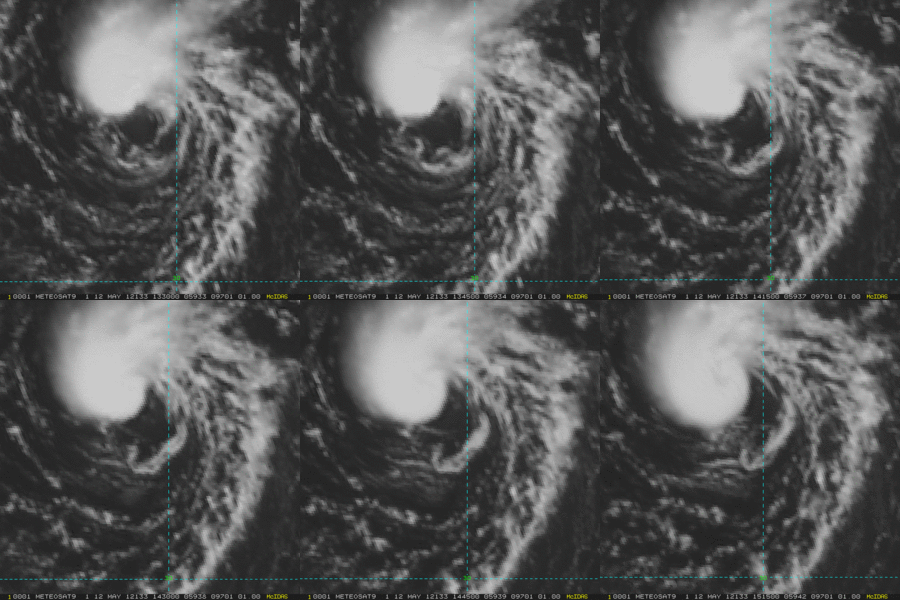
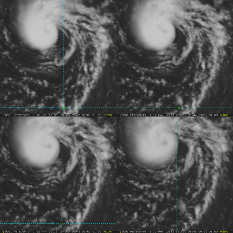
Image

Latest visible
0 likes   

User avatar
cycloneye
Admin
Admin
Posts: 139069
Age: 67
Joined: Thu Oct 10, 2002 10:54 am
Location: San Juan, Puerto Rico

Re: ATL: INVEST 92L

#6 Postby cycloneye » Sat May 12, 2012 11:56 am

Redux of Grace/Vince?

Image
0 likes   
Visit the Caribbean-Central America Weather Thread where you can find at first post web cams,radars
and observations from Caribbean basin members Click Here

tolakram
Admin
Admin
Posts: 19165
Age: 60
Joined: Sun Aug 27, 2006 8:23 pm
Location: Florence, KY (name is Mark)

Re: ATL: INVEST 92L

#7 Postby tolakram » Sat May 12, 2012 11:57 am

The infamous eye-like feature.
0 likes   
M a r k
- - - - -
Join us in chat: Storm2K Chatroom Invite. Android and IOS apps also available.

The posts in this forum are NOT official forecasts and should not be used as such. Posts are NOT endorsed by any professional institution or STORM2K.org. For official information and forecasts, please refer to NHC and NWS products.

User avatar
Hurricane Andrew
S2K Supporter
S2K Supporter
Posts: 1891
Age: 25
Joined: Sun May 23, 2010 2:53 pm
Location: KS

#8 Postby Hurricane Andrew » Sat May 12, 2012 11:57 am

Eye?
Cyclone, would NC even bother to upgrade?
0 likes   

The Enthusiast
NREMT-AEMT, WX nerd

Irene '11, Sandy '12, Irma '17 (SAR)

"Hard to think we were born to live this way..." -Wage War

User avatar
cycloneye
Admin
Admin
Posts: 139069
Age: 67
Joined: Thu Oct 10, 2002 10:54 am
Location: San Juan, Puerto Rico

Re: ATL: INVEST 92L

#9 Postby cycloneye » Sat May 12, 2012 12:01 pm

Great circulation.

Image
0 likes   
Visit the Caribbean-Central America Weather Thread where you can find at first post web cams,radars
and observations from Caribbean basin members Click Here

User avatar
Hurricane Andrew
S2K Supporter
S2K Supporter
Posts: 1891
Age: 25
Joined: Sun May 23, 2010 2:53 pm
Location: KS

#10 Postby Hurricane Andrew » Sat May 12, 2012 12:03 pm

Is it warm core?
0 likes   

The Enthusiast
NREMT-AEMT, WX nerd

Irene '11, Sandy '12, Irma '17 (SAR)

"Hard to think we were born to live this way..." -Wage War

User avatar
cycloneye
Admin
Admin
Posts: 139069
Age: 67
Joined: Thu Oct 10, 2002 10:54 am
Location: San Juan, Puerto Rico

Re: ATL: INVEST 92L

#11 Postby cycloneye » Sat May 12, 2012 12:06 pm

Non Tropical now,but GFS has it transition to warm core later.

Image
0 likes   
Visit the Caribbean-Central America Weather Thread where you can find at first post web cams,radars
and observations from Caribbean basin members Click Here

tolakram
Admin
Admin
Posts: 19165
Age: 60
Joined: Sun Aug 27, 2006 8:23 pm
Location: Florence, KY (name is Mark)

Re:

#12 Postby tolakram » Sat May 12, 2012 12:10 pm

Hurricane Andrew wrote:Eye?
Cyclone, would NC even bother to upgrade?


I did not say it was an eye. :) Eye-like feature is something often referred to when something looks like an eye but is probably not.
0 likes   
M a r k
- - - - -
Join us in chat: Storm2K Chatroom Invite. Android and IOS apps also available.

The posts in this forum are NOT official forecasts and should not be used as such. Posts are NOT endorsed by any professional institution or STORM2K.org. For official information and forecasts, please refer to NHC and NWS products.

User avatar
Hurricanehink
S2K Supporter
S2K Supporter
Posts: 2022
Joined: Sun Nov 16, 2003 2:05 pm
Location: New Jersey

#13 Postby Hurricanehink » Sat May 12, 2012 12:15 pm

I wish the NHC would at least put out an STWO. Not so much for our benefit, but to warn ships of the danger of this small, but well-organized and intensifying system.
0 likes   

JonathanBelles
Professional-Met
Professional-Met
Posts: 11430
Age: 33
Joined: Sat Dec 24, 2005 9:00 pm
Location: School: Florida State University (Tallahassee, FL) Home: St. Petersburg, Florida
Contact:

Re:

#14 Postby JonathanBelles » Sat May 12, 2012 12:24 pm

Hurricanehink wrote:I wish the NHC would at least put out an STWO. Not so much for our benefit, but to warn ships of the danger of this small, but well-organized and intensifying system.


The TAFB has been warning for 15-17 foot waves for a couple of days now.

BTW, just so I am not making a double post, here is my latest blog post:

http://jonathanbelles.wordpress.com/201 ... is-coming/
0 likes   

User avatar
P.K.
Professional-Met
Professional-Met
Posts: 5149
Joined: Thu Sep 23, 2004 5:57 pm
Location: Watford, England
Contact:

Re:

#15 Postby P.K. » Sat May 12, 2012 12:34 pm

Hurricanehink wrote:I wish the NHC would at least put out an STWO. Not so much for our benefit, but to warn ships of the danger of this small, but well-organized and intensifying system.


Meteo-France did already mention this low in their last bulletins.

WONT50 LFPW 120740

A
SECURITE ON METAREA 2, METEO-FRANCE,

WARNING NR 189 , SATURDAY 12 MAY 2012 AT 0735 UTC

GENERAL SYNOPSIS, SATURDAY 12 AT 00 UTC


HIGH 1042 50N16W, MOVING EAST A, EXPECTED 1033 50N07W BY 13/12 UTC,
ASSOCIATED RIDGE EXTENDED TO WEST.
THUNDERY LOW 1016 33N32W, SLOW-MOVING AND DEEPENING, EXPECTED 1011
34N31W BY 13/12 UTC.
FINISTERRE CONTINUING TO 13/00 UTC. NORTHEAST, LOCALLY 8 NEAR CAPE.
GUSTS.
ACORES : CONTINUING TO 12/18 UTC. NORTHEASTERLY LOCALLY 8 IN WEST.
GUSTS. CADIZ, GIBRALTAR STRAIT : CONTINUING TO 12/21 UTC. EAST 8 IN
AND LEEWARD STRAIT. SEVERE GUSTS.=

Also (I've removed most of the forecast areas here):

FQNT50 LFPW 120744

A
SECURITE
Weather bulletin for METAREA 2, METEO-FRANCE,
Toulouse, Saturday 12 May 2012 at 1015 UTC.

- Wind speed in BEAUFORT SCALE - Sea : Total significant -
- Please be aware, wind gusts can be a further 40 percent stronger
than the averages given here, and maximum waves may be up to twice
the significant height.


Part 1 : WARNING : 189


Part 2 : General synopsis, Saturday 12 at 00 UTC

Thundery low 1016 33N32W, slow-moving and deepening, expected
1011 34N31W by 13/12 UTC.
High 1042 50N16W, moving east a, expected 1033 50N07W by 13/12
UTC, associated ridge extended to west.
New high expected 1038 46N33W by 13/00UTC, moving west, expected
1036 47N39W by 13/12UTC.
ITCZ axis along 09N13W 08N20W 07N25W 03N39W.


Part 3 : Area forecasts to Sunday 13 at 12 UTC

ACORES :
In west : Northeasterly 5 to 7 locally 8, decreasing 4 or 6 later
temporarily 7 in northwest. Gusts. In east : Easterly 4 to 6,
decreasing 3 to 5 later. Rough or very rough in west, moderate or
rough in east. Thundery showers, squalls with gusts.

IRVING :
Cyclonic 4 to 6 locally 7, decreasing 3 to 5 locally 6 later.
Gusts. Rough in west, locally very rough in northwest at first,
moderat ein east, Northerly swell. Thundery showers, squalls with
gusts.

METEOR :
In west : Westerly 4 to 6 locally 3 in south, decreasing 3 or 4
later occasionally 5 in north, backing West or Southwest 3 or 4 at
end. In east : Northerly 2 to 4 locally 5 in far east. Moderate,
but rough in northwest, Northerly swell. Some thundery showers in
north.

Part 4 : outlook for next 24 hours :

Threat of Northeast near gale over FINISTERRE.
Threat of Easterly near gale over JOSEPHINE on monday.
Elsewhere no significant phenomenon expected.
0 likes   

User avatar
P.K.
Professional-Met
Professional-Met
Posts: 5149
Joined: Thu Sep 23, 2004 5:57 pm
Location: Watford, England
Contact:

Re: ATL: INVEST 92L

#16 Postby P.K. » Sat May 12, 2012 12:41 pm

ABNT20 KNHC 121739
TWOAT

SPECIAL TROPICAL WEATHER OUTLOOK
NWS NATIONAL HURRICANE CENTER MIAMI FL
140 PM EDT SAT MAY 12 2012

FOR THE NORTH ATLANTIC...CARIBBEAN SEA AND THE GULF OF MEXICO...

A NON-TROPICAL LOW OVER THE EASTERN ATLANTIC ABOUT 400 MILES
SOUTHWEST OF THE SOUTHERN AZORES ISLANDS HAS DEVELOPED THUNDERSTORM
ACTIVITY NEAR THE CENTER DURING THE PAST 24 HOURS. THERE IS SOME
POTENTIAL FOR ADDITIONAL DEVELOPMENT AS THE SYSTEM MOVES LITTLE
DURING THE NEXT COUPLE OF DAYS...AND THE LOW HAS A MEDIUM
CHANCE...40 PERCENT...OF BECOMING A SUBTROPICAL OR TROPICAL CYCLONE
DURING THE NEXT 48 HOURS. ADDITIONAL SPECIAL TROPICAL WEATHER
OUTLOOKS WILL BE ISSUED ON THIS SYSTEM LATER TODAY OR SUNDAY...IF
NECESSARY.

ELSEWHERE...TROPICAL CYCLONE FORMATION IS NOT EXPECTED DURING THE
NEXT 48 HOURS.

$$
FORECASTER BEVEN
0 likes   

User avatar
cycloneye
Admin
Admin
Posts: 139069
Age: 67
Joined: Thu Oct 10, 2002 10:54 am
Location: San Juan, Puerto Rico

Re: ATL: INVEST 92L

#17 Postby cycloneye » Sat May 12, 2012 1:19 pm

P.K. wrote:ABNT20 KNHC 121739
TWOAT

SPECIAL TROPICAL WEATHER OUTLOOK
NWS NATIONAL HURRICANE CENTER MIAMI FL
140 PM EDT SAT MAY 12 2012

FOR THE NORTH ATLANTIC...CARIBBEAN SEA AND THE GULF OF MEXICO...

A NON-TROPICAL LOW OVER THE EASTERN ATLANTIC ABOUT 400 MILES
SOUTHWEST OF THE SOUTHERN AZORES ISLANDS HAS DEVELOPED THUNDERSTORM
ACTIVITY NEAR THE CENTER DURING THE PAST 24 HOURS. THERE IS SOME
POTENTIAL FOR ADDITIONAL DEVELOPMENT AS THE SYSTEM MOVES LITTLE
DURING THE NEXT COUPLE OF DAYS...AND THE LOW HAS A MEDIUM
CHANCE...40 PERCENT...OF BECOMING A SUBTROPICAL OR TROPICAL CYCLONE
DURING THE NEXT 48 HOURS. ADDITIONAL SPECIAL TROPICAL WEATHER
OUTLOOKS WILL BE ISSUED ON THIS SYSTEM LATER TODAY OR SUNDAY...IF
NECESSARY.

ELSEWHERE...TROPICAL CYCLONE FORMATION IS NOT EXPECTED DURING THE
NEXT 48 HOURS.

$$
FORECASTER BEVEN


Image
0 likes   
Visit the Caribbean-Central America Weather Thread where you can find at first post web cams,radars
and observations from Caribbean basin members Click Here

User avatar
cycloneye
Admin
Admin
Posts: 139069
Age: 67
Joined: Thu Oct 10, 2002 10:54 am
Location: San Juan, Puerto Rico

Re: ATL: INVEST 92L=Special Tropical Weather Outlook=40%

#18 Postby cycloneye » Sat May 12, 2012 1:22 pm

Wow!!

12/1745 UTC 33.5N 30.5W ST3.5 92L -- Atlantic

http://www.ssd.noaa.gov/PS/TROP/tdpositions.html

0 likes   
Visit the Caribbean-Central America Weather Thread where you can find at first post web cams,radars
and observations from Caribbean basin members Click Here

User avatar
bg1
Category 1
Category 1
Posts: 408
Joined: Fri May 13, 2011 11:14 am
Location: near Santee, SC

Re: ATL: INVEST 92L=Special Tropical Weather Outlook=40%

#19 Postby bg1 » Sat May 12, 2012 1:28 pm

cycloneye wrote:Wow!!

12/1745 UTC 33.5N 30.5W ST3.5 92L -- Atlantic

http://www.ssd.noaa.gov/PS/TROP/tdpositions.html


So, it's about 55 kts? Or is the scale different for subtropical cyclones?
0 likes   

User avatar
cycloneye
Admin
Admin
Posts: 139069
Age: 67
Joined: Thu Oct 10, 2002 10:54 am
Location: San Juan, Puerto Rico

Re: ATL: INVEST 92L

#20 Postby cycloneye » Sat May 12, 2012 1:29 pm

18z Best Track

AL, 92, 2012051218, , BEST, 0, 335N, 305W, 45, 1009, LO

ftp://ftp.nhc.noaa.gov/atcf/tcweb/inves ... 012.invest
0 likes   
Visit the Caribbean-Central America Weather Thread where you can find at first post web cams,radars
and observations from Caribbean basin members Click Here


Return to “2012”

Who is online

Users browsing this forum: No registered users and 107 guests