BEGIN
NHC_ATCF
invest_ep932012.invest
FSTDA
R
U
040
010
0000
201208072146
NONE
NOTIFY=ATRP
END
INVEST, EP, E, , , , , 93, 2012, DB, O, 2012080718, 9999999999, , , , , , METWATCH, , EP932012
EP, 93, 2012080618, , BEST, 0, 88N, 974W, 25, 1009, DB, 0, , 0, 0, 0, 0,
EP, 93, 2012080700, , BEST, 0, 91N, 982W, 25, 1009, DB, 0, , 0, 0, 0, 0,
EP, 93, 2012080706, , BEST, 0, 94N, 989W, 25, 1009, DB, 0, , 0, 0, 0, 0,
EP, 93, 2012080712, , BEST, 0, 98N, 997W, 25, 1009, DB, 0, , 0, 0, 0, 0,
EP, 93, 2012080718, , BEST, 0, 102N, 1005W, 25, 1008, DB, 34, NEQ, 0, 0, 0, 0, 1010, 150, 0, 0, 0, E, 0, , 0, 0, INVEST, S,
EPAC: INVEST 93E
Moderator: S2k Moderators
-
Kingarabian

- S2K Supporter

- Posts: 15434
- Joined: Sat Aug 08, 2009 3:06 am
- Location: Honolulu, Hawaii
-
Kingarabian
- S2K Supporter
- Posts: 15434
- Joined: Sat Aug 08, 2009 3:06 am
- Location: Honolulu, Hawaii

-
tolakram
- Admin

- Posts: 19165
- Age: 60
- Joined: Sun Aug 27, 2006 8:23 pm
- Location: Florence, KY (name is Mark)
Re: EPAC: INVEST 93E
Floater loop. Man I love these new animated gifs
http://www.ssd.noaa.gov/PS/TROP/floater ... oater.html
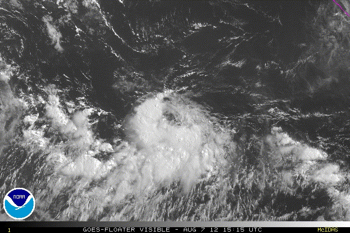
http://www.ssd.noaa.gov/PS/TROP/floater ... oater.html
0 likes
M a r k
- - - - -
Join us in chat: Storm2K Chatroom Invite. Android and IOS apps also available.
The posts in this forum are NOT official forecasts and should not be used as such. Posts are NOT endorsed by any professional institution or STORM2K.org. For official information and forecasts, please refer to NHC and NWS products.
-
Yellow Evan

- Professional-Met

- Posts: 15951
- Age: 25
- Joined: Fri Jul 15, 2011 12:48 pm
- Location: Henderson, Nevada/Honolulu, HI
- Contact:
-
hurricanes1234
- Category 5

- Posts: 2903
- Joined: Sat Jul 28, 2012 6:19 pm
- Location: Trinidad and Tobago
Re: EPAC: INVEST 93E
Losing some of its convection...as cloudtops have been warming substantially over the last 3-5 hours. Like Gilma, when it was still an invest, this shouldn't have any effects on it because the environment is moist. It seems to be doing what I call the "rainband replacement cycle" where most of the bands briefly diminish and return in a more compact, more organized structure than before.
Just my opinion.
Just my opinion.
0 likes
PLEASE NOTE: With the exception of information from weather agencies that I may copy and paste here, my posts will NEVER be official, since I am NOT a meteorologist. They are solely my amateur opinion, and may or may not be accurate. Therefore, please DO NOT use them as official details, particularly when making important decisions. Thank you.
-
Kingarabian
- S2K Supporter
- Posts: 15434
- Joined: Sat Aug 08, 2009 3:06 am
- Location: Honolulu, Hawaii
1. SHOWERS AND THUNDERSTORMS ASSOCIATED WITH AN AREA OF LOW PRESSURE
LOCATED ABOUT 450 MILES SOUTH OF ACAPULCO MEXICO HAVE BECOME MUCH
BETTER ORGANIZED DURING THE LAST SEVERAL HOURS. ADDITIONAL
DEVELOPMENT OF THIS SYSTEM IS POSSIBLE AND IT COULD BECOME A
TROPICAL DEPRESSION DURING THE NEXT DAY OR TWO. THIS SYSTEM HAS
A MEDIUM CHANCE...40 PERCENT...OF BECOMING A TROPICAL CYCLONE AS IT
DRIFTS WESTWARD DURING THE NEXT 48 HOURS.
ELSEWHERE...TROPICAL CYCLONE FORMATION IS NOT EXPECTED DURING THE
NEXT 48 HOURS.
0 likes
RIP Kobe Bryant
-
Yellow Evan
- Professional-Met
- Posts: 15951
- Age: 25
- Joined: Fri Jul 15, 2011 12:48 pm
- Location: Henderson, Nevada/Honolulu, HI
- Contact:

Yep not a bad looking system, I expect to see some sort of development from this system.
0 likes
Personal Forecast Disclaimer:
The posts in this forum are NOT official forecast and should not be used as such. They are just the opinion of the poster and may or may not be backed by sound meteorological data. They are NOT endorsed by any professional institution or storm2k.org. For official information, please refer to the NHC and NWS products
The posts in this forum are NOT official forecast and should not be used as such. They are just the opinion of the poster and may or may not be backed by sound meteorological data. They are NOT endorsed by any professional institution or storm2k.org. For official information, please refer to the NHC and NWS products
-
tolakram
- Admin
- Posts: 19165
- Age: 60
- Joined: Sun Aug 27, 2006 8:23 pm
- Location: Florence, KY (name is Mark)
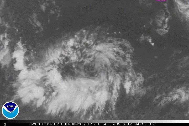
Re: EPAC: INVEST 93E
latest ir loop
0 likes
M a r k
- - - - -
Join us in chat: Storm2K Chatroom Invite. Android and IOS apps also available.
The posts in this forum are NOT official forecasts and should not be used as such. Posts are NOT endorsed by any professional institution or STORM2K.org. For official information and forecasts, please refer to NHC and NWS products.
- - - - -
Join us in chat: Storm2K Chatroom Invite. Android and IOS apps also available.
The posts in this forum are NOT official forecasts and should not be used as such. Posts are NOT endorsed by any professional institution or STORM2K.org. For official information and forecasts, please refer to NHC and NWS products.
-
cycloneye

- Admin
- Posts: 139067
- Age: 67
- Joined: Thu Oct 10, 2002 10:54 am
- Location: San Juan, Puerto Rico
Re: EPAC: INVEST 93E
TROPICAL WEATHER OUTLOOK
NWS NATIONAL HURRICANE CENTER MIAMI FL
500 AM PDT WED AUG 8 2012
FOR THE EASTERN NORTH PACIFIC...EAST OF 140 DEGREES WEST LONGITUDE..
THE NATIONAL HURRICANE CENTER IS ISSUING ADVISORIES ON
TROPICAL STORM GILMA...LOCATED ABOUT 645 MILES SOUTHWEST OF
THE SOUTHERN TIP OF BAJA CALIFORNIA.
SHOWERS AND THUNDERSTORMS ASSOCIATED WITH AN AREA OF LOW PRESSURE
LOCATED ABOUT 450 MILES SOUTH-SOUTHWEST OF ACAPULCO MEXICO HAVE
CHANGED LITTLE IN ORGANIZATION DURING THE PAST SEVERAL HOURS.
HOWEVER...DEVELOPMENT OF THIS SYSTEM IS POSSIBLE AND IT COULD
BECOME A TROPICAL DEPRESSION DURING THE NEXT COUPLE OF DAYS. THIS
SYSTEM HAS A MEDIUM CHANCE...40 PERCENT...OF BECOMING A TROPICAL
CYCLONE AS IT MOVES LITTLE DURING THE NEXT 48 HOURS.
ELSEWHERE...TROPICAL CYCLONE FORMATION IS NOT EXPECTED DURING THE
NEXT 48 HOURS.
$$
FORECASTER BEVEN
0 likes
Visit the Caribbean-Central America Weather Thread where you can find at first post web cams,radars
and observations from Caribbean basin members Click Here
and observations from Caribbean basin members Click Here
Convection still isn't the strongest with it but it is still firing up convection and the rotation is fairly obvious with it as well.
0 likes
Personal Forecast Disclaimer:
The posts in this forum are NOT official forecast and should not be used as such. They are just the opinion of the poster and may or may not be backed by sound meteorological data. They are NOT endorsed by any professional institution or storm2k.org. For official information, please refer to the NHC and NWS products
The posts in this forum are NOT official forecast and should not be used as such. They are just the opinion of the poster and may or may not be backed by sound meteorological data. They are NOT endorsed by any professional institution or storm2k.org. For official information, please refer to the NHC and NWS products
-
cycloneye
- Admin
- Posts: 139067
- Age: 67
- Joined: Thu Oct 10, 2002 10:54 am
- Location: San Juan, Puerto Rico
Re: EPAC: INVEST 93E
Up to 40%.
TROPICAL WEATHER OUTLOOK
NWS NATIONAL HURRICANE CENTER MIAMI FL
1100 AM PDT WED AUG 8 2012
FOR THE EASTERN NORTH PACIFIC...EAST OF 140 DEGREES WEST LONGITUDE..
THE NATIONAL HURRICANE CENTER IS ISSUING ADVISORIES ON TROPICAL
STORM GILMA...LOCATED ABOUT 670 MILES SOUTHWEST OF THE SOUTHERN TIP
OF BAJA CALIFORNIA.
SHOWERS AND THUNDERSTORMS ASSOCIATED WITH AN AREA OF LOW PRESSURE
LOCATED ABOUT 500 MILES SOUTH-SOUTHWEST OF ACAPULCO MEXICO CONTINUE
TO SHOW SIGNS OF ORGANIZATION. DEVELOPMENT OF THIS SYSTEM IS
POSSIBLE...AND IT COULD BECOME A TROPICAL DEPRESSION DURING THE
NEXT COUPLE OF DAYS. THIS SYSTEM HAS A MEDIUM CHANCE...40
PERCENT...OF BECOMING A TROPICAL CYCLONE AS IT MOVES LITTLE DURING
THE NEXT 48 HOURS.
ELSEWHERE...TROPICAL CYCLONE FORMATION IS NOT EXPECTED DURING THE
NEXT 48 HOURS.
$$
FORECASTER BEVEN
0 likes
Visit the Caribbean-Central America Weather Thread where you can find at first post web cams,radars
and observations from Caribbean basin members Click Here
and observations from Caribbean basin members Click Here
-
tolakram
- Admin
- Posts: 19165
- Age: 60
- Joined: Sun Aug 27, 2006 8:23 pm
- Location: Florence, KY (name is Mark)
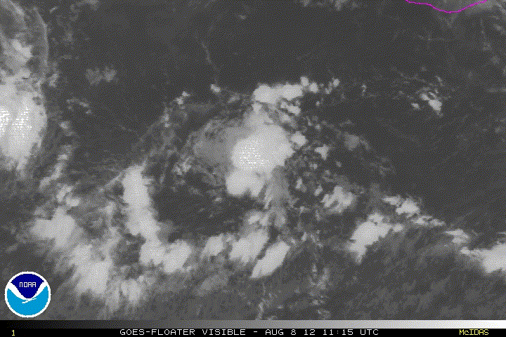
Re: EPAC: INVEST 93E
latest visible loop
0 likes
M a r k
- - - - -
Join us in chat: Storm2K Chatroom Invite. Android and IOS apps also available.
The posts in this forum are NOT official forecasts and should not be used as such. Posts are NOT endorsed by any professional institution or STORM2K.org. For official information and forecasts, please refer to NHC and NWS products.
- - - - -
Join us in chat: Storm2K Chatroom Invite. Android and IOS apps also available.
The posts in this forum are NOT official forecasts and should not be used as such. Posts are NOT endorsed by any professional institution or STORM2K.org. For official information and forecasts, please refer to NHC and NWS products.
-
cycloneye
- Admin
- Posts: 139067
- Age: 67
- Joined: Thu Oct 10, 2002 10:54 am
- Location: San Juan, Puerto Rico
Re: EPAC: INVEST 93E
18z Best Track
EP, 93, 2012080818, , BEST, 0, 108N, 1037W, 25, 1008, LO
ftp://ftp.nhc.noaa.gov/atcf/tcweb/inves ... 012.invest
EP, 93, 2012080818, , BEST, 0, 108N, 1037W, 25, 1008, LO
ftp://ftp.nhc.noaa.gov/atcf/tcweb/inves ... 012.invest
0 likes
Visit the Caribbean-Central America Weather Thread where you can find at first post web cams,radars
and observations from Caribbean basin members Click Here
and observations from Caribbean basin members Click Here
-
hurricanes1234
- Category 5
- Posts: 2903
- Joined: Sat Jul 28, 2012 6:19 pm
- Location: Trinidad and Tobago
Re: EPAC: INVEST 93E
cycloneye wrote:18z Best Track
EP, 93, 2012080818, , BEST, 0, 108N, 1037W, 25, 1008, LO
ftp://ftp.nhc.noaa.gov/atcf/tcweb/inves ... 012.invest
What does this mean? 25 kt winds and pressure at 1008 mbar?
0 likes
PLEASE NOTE: With the exception of information from weather agencies that I may copy and paste here, my posts will NEVER be official, since I am NOT a meteorologist. They are solely my amateur opinion, and may or may not be accurate. Therefore, please DO NOT use them as official details, particularly when making important decisions. Thank you.
-
brunota2003

- S2K Supporter
- Posts: 9476
- Age: 33
- Joined: Sat Jul 30, 2005 9:56 pm
- Location: Stanton, KY...formerly Havelock, NC
- Contact:
Re: EPAC: INVEST 93E
hurricanes1234 wrote:cycloneye wrote:18z Best Track
EP, 93, 2012080818, , BEST, 0, 108N, 1037W, 25, 1008, LO
ftp://ftp.nhc.noaa.gov/atcf/tcweb/inves ... 012.invest
What does this mean? 25 kt winds and pressure at 1008 mbar?
Yes.
Break down for those who may not know what that means:
EP - East Pacific
93 - 93E
2012080818 - August 8, 2012 at 18Z
BEST - Best Track
0 - Not sure?
108N - 10.8 Degrees North Latitude
1037W - 103.7 Degrees West Longitude
25 - 25 knots
1008 - 1008 millibars
LO - Area of low pressure
0 likes
Just a small town southern boy helping other humans.
-
hurricanes1234
- Category 5
- Posts: 2903
- Joined: Sat Jul 28, 2012 6:19 pm
- Location: Trinidad and Tobago
Re: EPAC: INVEST 93E
Thanks.
0 likes
PLEASE NOTE: With the exception of information from weather agencies that I may copy and paste here, my posts will NEVER be official, since I am NOT a meteorologist. They are solely my amateur opinion, and may or may not be accurate. Therefore, please DO NOT use them as official details, particularly when making important decisions. Thank you.
-
cycloneye
- Admin
- Posts: 139067
- Age: 67
- Joined: Thu Oct 10, 2002 10:54 am
- Location: San Juan, Puerto Rico
Re: EPAC: INVEST 93E
Down from 40% to 30%.
TROPICAL WEATHER OUTLOOK
NWS NATIONAL HURRICANE CENTER MIAMI FL
500 PM PDT WED AUG 8 2012
FOR THE EASTERN NORTH PACIFIC...EAST OF 140 DEGREES WEST LONGITUDE..
THE NATIONAL HURRICANE CENTER IS ISSUING ADVISORIES ON TROPICAL
STORM GILMA...LOCATED ABOUT 695 MILES SOUTHWEST OF THE SOUTHERN TIP
OF BAJA CALIFORNIA.
AN AREA OF LOW PRESSURE LOCATED ABOUT 470 MILES SOUTH-SOUTHWEST OF
ACAPULCO MEXICO CONTINUES TO PRODUCE SHOWERS AND THUNDERSTORMS
MAINLY TO THE WEST OF ITS CENTER. DEVELOPMENT OF THIS SYSTEM
APPEARS A LITTLE LESS LIKELY AS UPPER-LEVEL WINDS ARE FORECAST TO
BECOME LESS FAVORABLE IN A DAY OR TWO. THIS SYSTEM HAS A MEDIUM
CHANCE...30 PERCENT...OF BECOMING A TROPICAL CYCLONE AS IT MOVES
LITTLE DURING THE NEXT 48 HOURS.
ELSEWHERE...TROPICAL CYCLONE FORMATION IS NOT EXPECTED DURING THE
NEXT 48 HOURS.
$$
FORECASTER CANGIALOSI
0 likes
Visit the Caribbean-Central America Weather Thread where you can find at first post web cams,radars
and observations from Caribbean basin members Click Here
and observations from Caribbean basin members Click Here
-
hurricanes1234
- Category 5
- Posts: 2903
- Joined: Sat Jul 28, 2012 6:19 pm
- Location: Trinidad and Tobago
Re: EPAC: INVEST 93E
I would give this low a 70 percent chance of not developing into 8E/Hector.
________________
The posts in this forum are NOT official forecast and should not be used as such. They are just the opinion of the poster and may or may not be backed by sound meteorological data. They are NOT endorsed by any professional institution or storm2k.org. For official information, please refer to the NHC and NWS products.
0 likes
PLEASE NOTE: With the exception of information from weather agencies that I may copy and paste here, my posts will NEVER be official, since I am NOT a meteorologist. They are solely my amateur opinion, and may or may not be accurate. Therefore, please DO NOT use them as official details, particularly when making important decisions. Thank you.
-
hurricanes1234
- Category 5
- Posts: 2903
- Joined: Sat Jul 28, 2012 6:19 pm
- Location: Trinidad and Tobago
Re: EPAC: INVEST 93E
At least he tried. 
0 likes
PLEASE NOTE: With the exception of information from weather agencies that I may copy and paste here, my posts will NEVER be official, since I am NOT a meteorologist. They are solely my amateur opinion, and may or may not be accurate. Therefore, please DO NOT use them as official details, particularly when making important decisions. Thank you.
Who is online
Users browsing this forum: No registered users and 115 guests