Every invest deserves a thread.
1. CLOUDINESS AND SHOWERS EXTENDING FROM OFFSHORE OF THE SOUTHWEST
COAST OF MEXICO TO THE SOUTHERN GULF OF CALIFORNIA ARE ASSOCIATED
WITH A TROUGH OF LOW PRESSURE. ALTHOUGH SOME SLOW DEVELOPMENT OF
THIS DISTURBANCE IS POSSIBLE DURING THE NEXT DAY OR SO...
ENVIRONMENTAL CONDITIONS ARE EXPECTED TO BECOME UNFAVORABLE AFTER
THAT TIME. THIS SYSTEM HAS A LOW CHANCE...10 PERCENT...OF BECOMING
A TROPICAL CYCLONE DURING THE NEXT 48 HOURS AS IT MOVES SLOWLY
NORTHWESTWARD.
EPAC: INVEST 96E
Moderator: S2k Moderators
-
Extratropical94

- Professional-Met

- Posts: 3535
- Age: 29
- Joined: Wed Oct 20, 2010 6:36 am
- Location: Hamburg, Germany
- Contact:
EPAC: INVEST 96E
0 likes
54° 11' 59'' N, 9° 9' 20'' E
Boomer Sooner!
Go Broncos! Go Cards! Go Niners!
- Daniel
Boomer Sooner!
Go Broncos! Go Cards! Go Niners!
- Daniel
-
Extratropical94
- Professional-Met
- Posts: 3535
- Age: 29
- Joined: Wed Oct 20, 2010 6:36 am
- Location: Hamburg, Germany
- Contact:
Here's the initialization file btw:
BEGIN
NHC_ATCF
invest_ep962012.invest
FSTDA
R
U
040
010
0000
201208191854
NONE
NOTIFY=ATRP
END
INVEST, EP, E, , , , , 96, 2012, DB, O, 2012081912, 9999999999, , , , , , METWATCH, , EP962012
EP, 96, 2012081900, , BEST, 0, 177N, 1048W, 25, 1009, DB, 0, , 0, 0, 0, 0,
EP, 96, 2012081906, , BEST, 0, 178N, 1051W, 25, 1009, DB, 0, , 0, 0, 0, 0,
EP, 96, 2012081912, , BEST, 0, 180N, 1054W, 25, 1009, DB, 0, , 0, 0, 0, 0,
EP, 96, 2012081918, , BEST, 0, 183N, 1059W, 25, 1010, DB, 34, NEQ, 0, 0, 0, 0, 1012, 150, 60, 0, 0, E, 0, , 0, 0, INVEST, S,
0 likes
54° 11' 59'' N, 9° 9' 20'' E
Boomer Sooner!
Go Broncos! Go Cards! Go Niners!
- Daniel
Boomer Sooner!
Go Broncos! Go Cards! Go Niners!
- Daniel
-
hurricanes1234
- Category 5

- Posts: 2903
- Joined: Sat Jul 28, 2012 6:19 pm
- Location: Trinidad and Tobago
Re: EPAC: INVEST 96E
POOF! It's gone. Or is it?
______________
The posts in this forum are NOT official forecast and should not be used as such. They are just the opinion of the poster and may or may not be backed by sound meteorological data. They are NOT endorsed by any professional institution or storm2k.org. For official information, please refer to the NHC and NWS products.
0 likes
PLEASE NOTE: With the exception of information from weather agencies that I may copy and paste here, my posts will NEVER be official, since I am NOT a meteorologist. They are solely my amateur opinion, and may or may not be accurate. Therefore, please DO NOT use them as official details, particularly when making important decisions. Thank you.
-
Extratropical94
- Professional-Met
- Posts: 3535
- Age: 29
- Joined: Wed Oct 20, 2010 6:36 am
- Location: Hamburg, Germany
- Contact:
Re: EPAC: INVEST 96E
hurricanes1234 wrote:POOF! It's gone. Or is it?
______________
The posts in this forum are NOT official forecast and should not be used as such. They are just the opinion of the poster and may or may not be backed by sound meteorological data. They are NOT endorsed by any professional institution or storm2k.org. For official information, please refer to the NHC and NWS products.
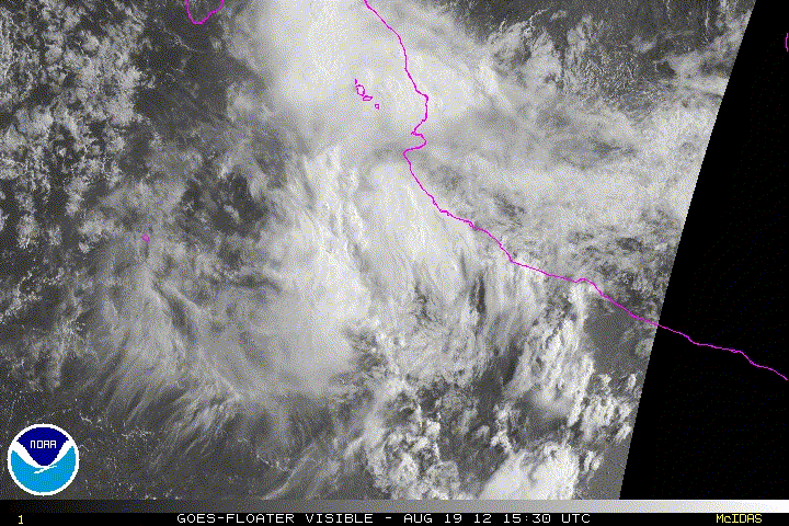
It has lost most of its convection and doesn't look very organized although the SSTs are still warm enough to support development (82-83F currently).
The window for possible cyclone formation is not that large though as it moves towards the NW, directly into cooler waters and much more stable air.
0 likes
54° 11' 59'' N, 9° 9' 20'' E
Boomer Sooner!
Go Broncos! Go Cards! Go Niners!
- Daniel
Boomer Sooner!
Go Broncos! Go Cards! Go Niners!
- Daniel
-
tolakram
- Admin

- Posts: 19165
- Age: 60
- Joined: Sun Aug 27, 2006 8:23 pm
- Location: Florence, KY (name is Mark)
Re: EPAC: INVEST 96E
Looks like it literally blew away. 
Saved loop
Saved loop
0 likes
M a r k
- - - - -
Join us in chat: Storm2K Chatroom Invite. Android and IOS apps also available.
The posts in this forum are NOT official forecasts and should not be used as such. Posts are NOT endorsed by any professional institution or STORM2K.org. For official information and forecasts, please refer to NHC and NWS products.
-
cycloneye

- Admin
- Posts: 139025
- Age: 67
- Joined: Thu Oct 10, 2002 10:54 am
- Location: San Juan, Puerto Rico
Re: EPAC: INVEST 96E
TROPICAL WEATHER OUTLOOK
NWS NATIONAL HURRICANE CENTER MIAMI FL
500 PM PDT SUN AUG 19 2012
FOR THE EASTERN NORTH PACIFIC...EAST OF 140 DEGREES WEST LONGITUDE..
CLOUDINESS AND SHOWERS EXTENDING FROM THE SOUTHWEST COAST OF MEXICO
TO THE SOUTHERN GULF OF CALIFORNIA ARE ASSOCIATED WITH A TROUGH OF
LOW PRESSURE. DEVELOPMENT...IF ANY...IS EXPECTED TO BE SLOW TO
OCCUR AS THE TROUGH MOVES SLOWS NORTHWESTWARD. THIS SYSTEM HAS A
LOW CHANCE...10 PERCENT...OF BECOMING A TROPICAL CYCLONE DURING THE
NEXT 48 HOURS.
ELSEWHERE...TROPICAL CYCLONE FORMATION IS NOT EXPECTED DURING THE
NEXT 48 HOURS.
$$
FORECASTER BLAKE
0 likes
Visit the Caribbean-Central America Weather Thread where you can find at first post web cams,radars
and observations from Caribbean basin members Click Here
and observations from Caribbean basin members Click Here
-
hurricanes1234
- Category 5
- Posts: 2903
- Joined: Sat Jul 28, 2012 6:19 pm
- Location: Trinidad and Tobago
Re: EPAC: INVEST 96E
I don't see any obvious circulation, nor any well-organized structure. I think it may have peaked the moment the NHC began monitoring it. 
______________
The posts in this forum are NOT official forecast and should not be used as such. They are just the opinion of the poster and may or may not be backed by sound meteorological data. They are NOT endorsed by any professional institution or storm2k.org. For official information, please refer to the NHC and NWS products.
0 likes
PLEASE NOTE: With the exception of information from weather agencies that I may copy and paste here, my posts will NEVER be official, since I am NOT a meteorologist. They are solely my amateur opinion, and may or may not be accurate. Therefore, please DO NOT use them as official details, particularly when making important decisions. Thank you.
-
Yellow Evan

- Professional-Met
- Posts: 15951
- Age: 25
- Joined: Fri Jul 15, 2011 12:48 pm
- Location: Henderson, Nevada/Honolulu, HI
- Contact:

96E is garbage material
Yellow Evan wrote:I think I see an LLC, The origins of the system look similar to Hector. Looks like the monsoon in the EPAC is doing its job.
Are you calling it a garbage system yet? It appears to be that with the Euro showing no formation in the Epac in the next 10 days (El Nino?) and the waters are cooler near Mexico than they were on May 10, you have the recipe for mediocrity.
0 likes
-
Yellow Evan
- Professional-Met
- Posts: 15951
- Age: 25
- Joined: Fri Jul 15, 2011 12:48 pm
- Location: Henderson, Nevada/Honolulu, HI
- Contact:
Re: 96E is garbage material
Cyclenall wrote:Yellow Evan wrote:I think I see an LLC, The origins of the system look similar to Hector. Looks like the monsoon in the EPAC is doing its job.
Are you calling it a garbage system yet? It appears to be that with the Euro showing no formation in the Epac in the next 10 days (El Nino?) and the waters are cooler near Mexico than they were on May 10, you have the recipe for mediocrity.
Yes, it looked quite nice earlier, but now most of the thunderstorm are about to move inland. But yea, this year has been extermly frustrating since mid-July.
0 likes
-
brunota2003

- S2K Supporter

- Posts: 9476
- Age: 33
- Joined: Sat Jul 30, 2005 9:56 pm
- Location: Stanton, KY...formerly Havelock, NC
- Contact:
TROPICAL WEATHER OUTLOOK
NWS NATIONAL HURRICANE CENTER MIAMI FL
1100 PM PDT SUN AUG 19 2012
FOR THE EASTERN NORTH PACIFIC...EAST OF 140 DEGREES WEST LONGITUDE..
A TROUGH OF LOW PRESSURE LOCATED A COUPLE HUNDRED MILES SOUTHEAST
OF THE SOUTHERN TIP OF BAJA CALIFORNIA IS PRODUCING DISORGANIZED
CLOUDINESS AND SHOWERS. DEVELOPMENT...IF ANY...OF THIS TROUGH IS
EXPECTED TO BE SLOW TO OCCUR AS IT MOVES SLOWLY NORTHWESTWARD. THIS
SYSTEM HAS A LOW CHANCE...10 PERCENT...OF BECOMING A TROPICAL
CYCLONE DURING THE NEXT 48 HOURS.
ELSEWHERE...TROPICAL CYCLONE FORMATION IS NOT EXPECTED DURING THE
NEXT 48 HOURS.
$$
FORECASTER CANGIALOSI
0 likes
Just a small town southern boy helping other humans.
-
hurricanes1234
- Category 5
- Posts: 2903
- Joined: Sat Jul 28, 2012 6:19 pm
- Location: Trinidad and Tobago
Re: EPAC: INVEST 96E
It's at near 0%.
POOF! Now it's gone for sure. The ePac this year has not produced any major hurricanes since last month, although August is supposedly the peak month of activity. But guys, let's not write off the season yet, if I can recall, many of us, including myself, gave up on the Atlantic and look how active it is now. We have Gordon, and three invests - one with a low chance, one with a medium chance, and one with a high chance, which is relatively rare.
______________
The posts in this forum are NOT official forecast and should not be used as such. They are just the opinion of the poster and may or may not be backed by sound meteorological data. They are NOT endorsed by any professional institution or storm2k.org. For official information, please refer to the NHC and NWS products.
0 likes
PLEASE NOTE: With the exception of information from weather agencies that I may copy and paste here, my posts will NEVER be official, since I am NOT a meteorologist. They are solely my amateur opinion, and may or may not be accurate. Therefore, please DO NOT use them as official details, particularly when making important decisions. Thank you.
-
Yellow Evan
- Professional-Met
- Posts: 15951
- Age: 25
- Joined: Fri Jul 15, 2011 12:48 pm
- Location: Henderson, Nevada/Honolulu, HI
- Contact:
Re: EPAC: INVEST 96E
hurricanes1234 wrote:It's at near 0%.
POOF! Now it's gone for sure. The ePac this year has not produced any major hurricanes since last month, although August is supposedly the peak month of activity. But guys, let's not write off the season yet, if I can recall, many of us, including myself, gave up on the Atlantic and look how active it is now. We have Gordon, and three invests - one with a low chance, one with a medium chance, and one with a high chance, which is relatively rare.
______________
The posts in this forum are NOT official forecast and should not be used as such. They are just the opinion of the poster and may or may not be backed by sound meteorological data. They are NOT endorsed by any professional institution or storm2k.org. For official information, please refer to the NHC and NWS products.
Well, we are in the hyperactive period of the ATL atm, while the EPAC is in a dead phase, so it will be harder for the EPAC to explode.
0 likes
-
Yellow Evan
- Professional-Met
- Posts: 15951
- Age: 25
- Joined: Fri Jul 15, 2011 12:48 pm
- Location: Henderson, Nevada/Honolulu, HI
- Contact:
1. A TROUGH OF LOW PRESSURE LOCATED A COUPLE HUNDRED MILES SOUTHEAST
OF THE SOUTHERN TIP OF BAJA CALIFORNIA IS PRODUCING DISORGANIZED
CLOUDINESS AND SHOWERS. DEVELOPMENT IS NOT EXPECTED...AND THIS
SYSTEM HAS A LOW CHANCE...NEAR 0 PERCENT...OF BECOMING A TROPICAL
CYCLONE DURING THE NEXT 48 HOURS.
OF THE SOUTHERN TIP OF BAJA CALIFORNIA IS PRODUCING DISORGANIZED
CLOUDINESS AND SHOWERS. DEVELOPMENT IS NOT EXPECTED...AND THIS
SYSTEM HAS A LOW CHANCE...NEAR 0 PERCENT...OF BECOMING A TROPICAL
CYCLONE DURING THE NEXT 48 HOURS.
0 likes
-
cycloneye
- Admin
- Posts: 139025
- Age: 67
- Joined: Thu Oct 10, 2002 10:54 am
- Location: San Juan, Puerto Rico
Re: EPAC: INVEST 96E
NHC_ATCF
invest_DEACTIVATE_ep962012.ren
FSTDA
R
U
040
010
0000
201208201242
NONE
NOTIFY=ATRP
END
invest_DEACTIVATE_ep962012.ren
FSTDA
R
U
040
010
0000
201208201242
NONE
NOTIFY=ATRP
END
0 likes
Visit the Caribbean-Central America Weather Thread where you can find at first post web cams,radars
and observations from Caribbean basin members Click Here
and observations from Caribbean basin members Click Here
-
Yellow Evan
- Professional-Met
- Posts: 15951
- Age: 25
- Joined: Fri Jul 15, 2011 12:48 pm
- Location: Henderson, Nevada/Honolulu, HI
- Contact:
-
hurricanes1234
- Category 5
- Posts: 2903
- Joined: Sat Jul 28, 2012 6:19 pm
- Location: Trinidad and Tobago
Re:
Yellow Evan wrote:Goodbye 96E. That was quick
Sort of like the recent invests in this basin - dissipating at 10 or 20% within 24-36 hours of being monitored. Unusually quiet for this time of year - the waters have also cooled since earlier this month.
0 likes
PLEASE NOTE: With the exception of information from weather agencies that I may copy and paste here, my posts will NEVER be official, since I am NOT a meteorologist. They are solely my amateur opinion, and may or may not be accurate. Therefore, please DO NOT use them as official details, particularly when making important decisions. Thank you.
Who is online
Users browsing this forum: No registered users and 36 guests