ATL: ANA - Advisories

Moderator: S2k Moderators

Message
Author
User avatar
TheAustinMan
Category 4
Category 4
Posts: 995
Age: 24
Joined: Mon Jul 08, 2013 4:26 pm
Location: United States
Contact:

ATL: ANA - Advisories

#1 Postby TheAustinMan » Thu May 07, 2015 9:31 pm

Advisories began on Subtropical Storm Ana during the fading hours of May 7, 2015 (11 p.m. US Eastern Time) off the coast of the Southeastern United States; before developing, the precursor area of interest that led to Ana was designated as 90L.INVEST. This thread is solely for the posting of NHC/NWS advisories and related tropical cyclone warning products (discussions, forecast discussions). Threads for other content may be located at one of the following links:

Advisory 1
Image
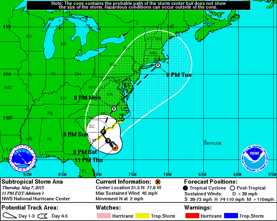
The above is the NHC forecast track for this advisory, which projects the anticipated path of Ana 5 days out. For more information on maps like this, see http://www.nhc.noaa.gov/aboutcone.shtml.
Public Advisory

Code: Select all

ZCZC MIATCPAT1 ALL
TTAA00 KNHC DDHHMM

BULLETIN
SUBTROPICAL STORM ANA ADVISORY NUMBER   1
NWS NATIONAL HURRICANE CENTER MIAMI FL       AL012015
1100 PM EDT THU MAY 07 2015

...SUBTROPICAL STORM ANA FORMS OFF THE SOUTHEAST U.S. COAST...


SUMMARY OF 1100 PM EDT...0300 UTC...INFORMATION
-----------------------------------------------
LOCATION...31.5N 77.6W
ABOUT 170 MI...275 KM SSE OF MYRTLE BEACH SOUTH CAROLINA
MAXIMUM SUSTAINED WINDS...45 MPH...75 KM/H
PRESENT MOVEMENT...N OR 350 DEGREES AT 2 MPH...4 KM/H
MINIMUM CENTRAL PRESSURE...1004 MB...29.65 INCHES


WATCHES AND WARNINGS
--------------------
CHANGES WITH THIS ADVISORY:

A TROPICAL STORM WATCH HAS BEEN ISSUED FROM EDISTO BEACH SOUTH
CAROLINA TO CAPE LOOKOUT NORTH CAROLINA.

SUMMARY OF WATCHES AND WARNINGS IN EFFECT:

A TROPICAL STORM WATCH IS IN EFFECT FOR...
* EDISTO BEACH SOUTH CAROLINA TO CAPE LOOKOUT NORTH CAROLINA

A TROPICAL STORM WATCH MEANS THAT TROPICAL STORM CONDITIONS ARE
POSSIBLE WITHIN THE WATCH AREA, GENERALLY WITHIN 48 HOURS.

FOR STORM INFORMATION SPECIFIC TO YOUR AREA, INCLUDING POSSIBLE
INLAND WATCHES AND WARNINGS, PLEASE MONITOR PRODUCTS ISSUED BY YOUR
LOCAL NATIONAL WEATHER SERVICE FORECAST OFFICE.


DISCUSSION AND 48-HOUR OUTLOOK
------------------------------
AT 1100 PM EDT (0300 UTC), THE CENTER OF SUBTROPICAL STORM ANA WAS
LOCATED NEAR LATITUDE 31.5 NORTH, LONGITUDE 77.6 WEST.  THE STORM IS
MOVING TOWARD THE NORTH NEAR 2 MPH (4 KM/H).  A TURN TOWARD THE
NORTHWEST WITH A SLIGHT INCREASE IN FORWARD SPEED IS EXPECTED OVER
THE NEXT 48 HOURS.

MAXIMUM SUSTAINED WINDS ARE NEAR 45 MPH (75 KM/H) WITH HIGHER GUSTS.
SOME SLIGHT STRENGTHENING IS FORECAST DURING THE NEXT DAY OR SO.

WINDS OF 40 MPH EXTEND OUTWARD UP TO 160 MILES (260 KM) FROM THE
CENTER.

AN AIR FORCE RESERVE UNIT HURRICANE HUNTER AIRCRAFT OBSERVED A
MINIMUM CENTRAL PRESSURE OF 1004 MB (29.65 INCHES).


HAZARDS AFFECTING LAND
----------------------
WIND...TROPICAL STORM CONDITIONS ARE POSSIBLE WITHIN THE WATCH AREA
BY SATURDAY AFTERNOON OR EVENING.

RAINFALL...ANA IS EXPECTED TO PRODUCE RAINFALL ACCUMULATIONS OF 2 TO
4 INCHES OVER EASTERN PORTIONS OF NORTH CAROLINA AND SOUTH CAROLINA
THROUGH THE WEEKEND.

SURF...SWELLS GENERATED BY ANA ARE AFFECTING PORTIONS OF THE
SOUTHEASTERN U.S. COAST.  THESE SWELLS ARE LIKELY TO CAUSE LIFE-
THREATENING SURF AND RIP CURRENTS.


NEXT ADVISORY
-------------
NEXT INTERMEDIATE ADVISORY AT 200 AM EDT.
NEXT COMPLETE ADVISORY AT 500 AM EDT.

$$
FORECASTER PASCH

NNNN

Forecast Advisory

Code: Select all

ZCZC MIATCMAT1 ALL
TTAA00 KNHC DDHHMM

SUBTROPICAL STORM ANA FORECAST/ADVISORY NUMBER   1
NWS NATIONAL HURRICANE CENTER MIAMI FL       AL012015
0300 UTC FRI MAY 08 2015

CHANGES IN WATCHES AND WARNINGS WITH THIS ADVISORY...

A TROPICAL STORM WATCH HAS BEEN ISSUED FROM EDISTO BEACH SOUTH
CAROLINA TO CAPE LOOKOUT NORTH CAROLINA.

SUMMARY OF WATCHES AND WARNINGS IN EFFECT...

A TROPICAL STORM WATCH IS IN EFFECT FOR...
* EDISTO BEACH SOUTH CAROLINA TO CAPE LOOKOUT NORTH CAROLINA

A TROPICAL STORM WATCH MEANS THAT TROPICAL STORM CONDITIONS ARE
POSSIBLE WITHIN THE WATCH AREA...GENERALLY WITHIN 48 HOURS.

SUBTROPICAL STORM CENTER LOCATED NEAR 31.5N  77.6W AT 08/0300Z
POSITION ACCURATE WITHIN  25 NM

PRESENT MOVEMENT TOWARD THE NORTH OR 350 DEGREES AT   2 KT

ESTIMATED MINIMUM CENTRAL PRESSURE 1004 MB
MAX SUSTAINED WINDS  40 KT WITH GUSTS TO  50 KT.
34 KT.......140NE   0SE  80SW 120NW.
12 FT SEAS..120NE  90SE  90SW 120NW.
WINDS AND SEAS VARY GREATLY IN EACH QUADRANT.  RADII IN NAUTICAL
MILES ARE THE LARGEST RADII EXPECTED ANYWHERE IN THAT QUADRANT.

REPEAT...CENTER LOCATED NEAR 31.5N  77.6W AT 08/0300Z
AT 08/0000Z CENTER WAS LOCATED NEAR 31.4N  77.6W

FORECAST VALID 08/1200Z 31.6N  77.7W
MAX WIND  45 KT...GUSTS  55 KT.
34 KT...120NE  60SE  80SW 110NW.

FORECAST VALID 09/0000Z 31.7N  77.8W
MAX WIND  45 KT...GUSTS  55 KT.
34 KT...120NE  80SE  70SW  80NW.

FORECAST VALID 09/1200Z 31.9N  78.0W
MAX WIND  40 KT...GUSTS  50 KT.
34 KT...120NE  70SE  60SW  70NW.

FORECAST VALID 10/0000Z 32.3N  78.6W
MAX WIND  35 KT...GUSTS  45 KT.
34 KT...120NE  60SE  50SW  60NW.

FORECAST VALID 11/0000Z 33.4N  79.3W...INLAND
MAX WIND  30 KT...GUSTS  40 KT.

EXTENDED OUTLOOK. NOTE...ERRORS FOR TRACK HAVE AVERAGED NEAR 150 NM
ON DAY 4 AND 200 NM ON DAY 5...AND FOR INTENSITY NEAR 15 KT EACH DAY

OUTLOOK VALID 12/0000Z 36.1N  77.8W...POST-TROP/INLAND
MAX WIND  25 KT...GUSTS  35 KT.

OUTLOOK VALID 13/0000Z 41.0N  71.5W...POST-TROP/REMNT LOW
MAX WIND  25 KT...GUSTS  35 KT.

REQUEST FOR 3 HOURLY SHIP REPORTS WITHIN 300 MILES OF 31.5N  77.6W

NEXT ADVISORY AT 08/0900Z

$$
FORECASTER PASCH


NNNN


Forecast Discussion

Code: Select all

000
WTNT41 KNHC 080233
TCDAT1

SUBTROPICAL STORM ANA DISCUSSION NUMBER   1
NWS NATIONAL HURRICANE CENTER MIAMI FL       AL012015
1100 PM EDT THU MAY 07 2015

Satellite imagery shows some increase in deep convection this
evening, and the low pressure system off the southeast U.S. coast
is now being designated as a subtropical storm.  Based on adjusted
SFMR winds from a hurricane hunter aircraft that has been
investigating the system, the current intensity is set at 40
kt.  Data from the aircraft also show that the radius of maximum
winds has decreased somewhat from earlier today, but at 80 n mi it
is still too large to justify classifying Ana as a tropical cyclone
at this time.  Since there has been more deep convection occurring
near the center over the past several hours, it is becoming more
likely that Ana will make the transition into a tropical storm
within the next day or so.  The storm should remain situated near or
over the Gulf Stream for the next 24-36 hours, which would allow for
some slight strengthening.  Later in the period, as the cyclone
approaches the coast, weakening is expected due to the influence of
cooler shelf waters.

The system has not moved much over the past 24 hours and the
initial motion estimate is 350/2.  Ana is likely to remain located
to the south of a stubborn mid-tropospheric blocking pattern for the
next 48 hours or so.  Global models show the block breaking down
over the weekend, which should allow Ana to move inland over the
southeastern U.S. Near the end of the forecast period, the system
should accelerate northeastward in the flow ahead of a broad trough.
The official track forecast is close to the dynamical model
consensus.

We appreciate the assistance of the Air Force Hurricane Hunters for
providing valuable observations, given their limited resources
prior to the start of the regular Atlantic Hurricane Season.

Note that the name Ana is pronounced AH-nah.

FORECAST POSITIONS AND MAX WINDS

INIT  08/0300Z 31.5N  77.6W   40 KT  45 MPH
 12H  08/1200Z 31.6N  77.7W   45 KT  50 MPH
 24H  09/0000Z 31.7N  77.8W   45 KT  50 MPH
 36H  09/1200Z 31.9N  78.0W   40 KT  45 MPH
 48H  10/0000Z 32.3N  78.6W   35 KT  40 MPH
 72H  11/0000Z 33.4N  79.3W   30 KT  35 MPH...INLAND
 96H  12/0000Z 36.1N  77.8W   25 KT  30 MPH...POST-TROP/INLAND
120H  13/0000Z 41.0N  71.5W   25 KT  30 MPH...POST-TROP/REMNT LOW

$$
Forecaster Pasch
Last edited by TheAustinMan on Fri May 08, 2015 5:13 pm, edited 1 time in total.
0 likes   
ImageImageImage
- Treat my opinions with a grain of salt. For official information see your local weather service.

User avatar
cycloneye
Admin
Admin
Posts: 139028
Age: 67
Joined: Thu Oct 10, 2002 10:54 am
Location: San Juan, Puerto Rico

Re: ATL: ANA - Advisories

#2 Postby cycloneye » Fri May 08, 2015 4:55 am

BULLETIN
SUBTROPICAL STORM ANA ADVISORY NUMBER 2
NWS NATIONAL HURRICANE CENTER MIAMI FL AL012015
500 AM EDT FRI MAY 08 2015

...SUBTROPICAL STORM ANA CONTINUES TO DRIFT NORTH-NORTHWESTWARD
TOWARD THE SOUTHEASTERN U.S. COAST...


SUMMARY OF 500 AM EDT...0900 UTC...INFORMATION
----------------------------------------------
LOCATION...31.6N 77.8W
ABOUT 160 MI...255 KM SSE OF MYRTLE BEACH SOUTH CAROLINA
MAXIMUM SUSTAINED WINDS...45 MPH...75 KM/H
PRESENT MOVEMENT...NNW OR 330 DEGREES AT 1 MPH...2 KM/H
MINIMUM CENTRAL PRESSURE...1004 MB...29.65 INCHES


WATCHES AND WARNINGS
--------------------
CHANGES WITH THIS ADVISORY:

NONE.

SUMMARY OF WATCHES AND WARNINGS IN EFFECT:

A TROPICAL STORM WATCH IS IN EFFECT FOR...
* EDISTO BEACH SOUTH CAROLINA TO CAPE LOOKOUT NORTH CAROLINA

A TROPICAL STORM WATCH MEANS THAT TROPICAL STORM CONDITIONS ARE
POSSIBLE WITHIN THE WATCH AREA, GENERALLY WITHIN 48 HOURS.

FOR STORM INFORMATION SPECIFIC TO YOUR AREA, INCLUDING POSSIBLE
INLAND WATCHES AND WARNINGS, PLEASE MONITOR PRODUCTS ISSUED BY YOUR
LOCAL NATIONAL WEATHER SERVICE FORECAST OFFICE.


DISCUSSION AND 48-HOUR OUTLOOK
------------------------------
AT 500 AM EDT (0900 UTC), THE CENTER OF SUBTROPICAL STORM ANA WAS
LOCATED NEAR LATITUDE 31.6 NORTH, LONGITUDE 77.8 WEST. THE STORM IS
MOVING TOWARD THE NORTH-NORTHWEST NEAR 1 MPH (2 KM/H). A TURN
TOWARD THE NORTHWEST WITH A SLIGHT INCREASE IN FORWARD SPEED IS
EXPECTED OVER THE NEXT 48 HOURS.

MAXIMUM SUSTAINED WINDS ARE NEAR 45 MPH (75 KM/H) WITH HIGHER GUSTS.
SOME SLIGHT STRENGTHENING IS FORECAST DURING THE NEXT DAY OR SO.

WINDS OF 40 MPH EXTEND OUTWARD UP TO 160 MILES (260 KM) FROM THE
CENTER.

THE ESTIMATED MINIMUM CENTRAL PRESSURE IS 1004 MB (29.65 INCHES).


HAZARDS AFFECTING LAND
----------------------
WIND...TROPICAL STORM CONDITIONS ARE POSSIBLE WITHIN THE WATCH AREA
BY SATURDAY AFTERNOON OR EVENING.

RAINFALL...ANA IS EXPECTED TO PRODUCE RAINFALL ACCUMULATIONS OF 2 TO
4 INCHES OVER EASTERN PORTIONS OF NORTH CAROLINA AND SOUTH CAROLINA
THROUGH THE WEEKEND.

SURF...SWELLS GENERATED BY ANA ARE AFFECTING PORTIONS OF THE
SOUTHEASTERN U.S. COAST. THESE SWELLS ARE LIKELY TO CAUSE LIFE-
THREATENING SURF AND RIP CURRENTS.


NEXT ADVISORY
-------------
NEXT INTERMEDIATE ADVISORY AT 800 AM EDT.
NEXT COMPLETE ADVISORY AT 1100 AM EDT.

$$
FORECASTER STEWART


SUBTROPICAL STORM ANA DISCUSSION NUMBER 2
NWS NATIONAL HURRICANE CENTER MIAMI FL AL012015
500 AM EDT FRI MAY 08 2015

Subtropical Storm Ana has remained convectively challenged
overnight with only a small cluster of thunderstorms noted revolving
through the southern semicircle, and only shallow isolated
convection having recently developed in the inner-core region. The
initial intensity remains at 40 kt based on previous recon data and
the lack of any significant change in the overall convective
pattern since that flight.

The initial motion continues to be a slow drift to the northwest
or north-northwest at only 1-2 kt. Ana is embedded in a blocking
pattern that is expected to persist for the next 3 days or so until
a strong mid-tropospheric low/trough currently located over the
western U.S. moves into the central and southern Plains and nudges
Ana northward and eventually northeastward by early next week.
During the next 48 hours, Ana is expected to move toward the
southeastern U.S. at a very slow pace. The global and regional
models are in remarkably good agreement on this weak steering
pattern persisting through the weekend so, the official forecast
track is essentially just an update of the previous advisory track
and lies close to the consensus model TVCA.

Water vapor imagery indicates that a tight mid-/upper-level low has
finally become juxtaposed with the surface low, and the two have
remained nearly stationary over the relatively warm waters of the
Gulf Stream. However, intrusions of dry air into the inner core have
been noted in satellite imagery and upper-air data during the
past several hours, which have likely been the main reason for the
lack of deep convection developing near the center. But with the
lows now vertically stacked and expected to remain over SSTs of
at least 25C for the next 24 hours, some slight strengthening is
expected. Ana could also transition to a tropical storm during
that time. By 48 hours and beyond, however, Ana's slow movement will
take the cyclone over colder shelf waters of around 20C-22C, and
weakening is expected due to the air in the inner core becoming more
stable. Most of the global models now show Ana remaining a distinct
entity through the forecast period and accompanied by winds near
gale force. As a result, the forecast calls for Ana to remain an
extratropical low on Days 4 and 5. The official intensity forecast
is similar to the previous advisory and the Decay-SHIPS model.

FORECAST POSITIONS AND MAX WINDS

INIT 08/0900Z 31.6N 77.8W 40 KT 45 MPH
12H 08/1800Z 31.7N 77.8W 45 KT 50 MPH
24H 09/0600Z 31.9N 78.0W 45 KT 50 MPH
36H 09/1800Z 32.2N 78.2W 40 KT 45 MPH
48H 10/0600Z 32.8N 78.9W 35 KT 40 MPH
72H 11/0600Z 34.1N 79.3W 30 KT 35 MPH...INLAND
96H 12/0600Z 37.7N 75.0W 30 KT 35 MPH...POST-TROP/EXTRATROP
120H 13/0600Z 43.0N 65.0W 30 KT 35 MPH...POST-TROP/EXTRATROP

$$
Forecaster Stewart
0 likes   
Visit the Caribbean-Central America Weather Thread where you can find at first post web cams,radars
and observations from Caribbean basin members Click Here

User avatar
cycloneye
Admin
Admin
Posts: 139028
Age: 67
Joined: Thu Oct 10, 2002 10:54 am
Location: San Juan, Puerto Rico

Re: ATL: ANA - Advisories

#3 Postby cycloneye » Fri May 08, 2015 10:10 am

WTNT31 KNHC 081458
TCPAT1

BULLETIN
SUBTROPICAL STORM ANA ADVISORY NUMBER 3
NWS NATIONAL HURRICANE CENTER MIAMI FL AL012015
1100 AM EDT FRI MAY 08 2015

...TROPICAL STORM WARNING ISSUED FOR A PORTION OF THE CAROLINAS...


SUMMARY OF 1100 AM EDT...1500 UTC...INFORMATION
-----------------------------------------------
LOCATION...31.5N 77.3W
ABOUT 180 MI...285 KM SSE OF MYRTLE BEACH SOUTH CAROLINA
MAXIMUM SUSTAINED WINDS...45 MPH...75 KM/H
PRESENT MOVEMENT...STATIONARY
MINIMUM CENTRAL PRESSURE...1001 MB...29.56 INCHES


WATCHES AND WARNINGS
--------------------
CHANGES WITH THIS ADVISORY:

A Tropical Storm Warning has been issued from South Santee River
South Carolina to Surf City North Carolina.

SUMMARY OF WATCHES AND WARNINGS IN EFFECT:

A Tropical Storm Warning is in effect for...
* South Santee River to Surf City

A Tropical Storm Watch is in effect for...
* Edisto Beach South Carolina to South of South Santee River
* North of Surf City to Cape Lookout North Carolina

A Tropical Storm Warning means that tropical storm conditions are
expected somewhere within the warning area within 36 hours.

A Tropical Storm Watch means that tropical storm conditions are
possible within the watch area, in this case also within 36 hours.

Interests elsewhere in eastern North Carolina should monitor the
progress of Ana.

For storm information specific to your area, including possible
inland watches and warnings, please monitor products issued by your
local National Weather Service forecast office.


DISCUSSION AND 48-HOUR OUTLOOK
------------------------------
At 1100 AM EDT (1500 UTC), the center of Subtropical Storm Ana was
located near latitude 31.5 North, longitude 77.3 West. The storm has
been meandering during the past few hours, but is expected to begin
a north-northwestward motion later today. A turn toward the
northwest with a slight increase in forward speed is expected
tomorrow.

Maximum sustained winds remain near 45 mph (75 km/h), with higher
gusts. Although Ana is expected to make the transition to a
tropical storm later today, only small changes in strength are
expected while the storm approaches the coastine over the next
couple of days.

Winds of 40 mph extend outward up to 150 miles (240 km) from the
center.

The minimum central pressure reported by an Air Force Reserve
Reconnaissance Unit Aircraft was 1001 mb (29.56 inches).


HAZARDS AFFECTING LAND
----------------------
WIND: Tropical storm conditions are expected within the warning
area, and possible within the watch areas, by Saturday evening.

STORM SURGE: The combination of storm surge and the tide will cause
normally dry areas near the coast to be flooded by rising waters.
The water could reach 1 to 2 ft above ground at times of high tide
in coastal areas from Cape Hatteras, North Carolina southward
through South Carolina. For information specific to your area,
please see products issued by your local National Weather Service
forecast office.

RAINFALL: Ana is expected to produce rainfall accumulations of 2 to
4 inches, with isolated amounts of 6 inches, over eastern portions
of North Carolina and South Carolina through the weekend.

SURF: Swells generated by Ana are affecting portions of the
southeastern U.S. coast. These swells will likely cause life-
threatening surf and rip currents. Please see statements issued by
your local National Weather Service forecast office.


NEXT ADVISORY
-------------
Next intermediate advisory at 200 PM EDT.
Next complete advisory at 500 PM EDT.

$$
Forecaster Blake

SUBTROPICAL STORM ANA DISCUSSION NUMBER 3
NWS NATIONAL HURRICANE CENTER MIAMI FL AL012015
1100 AM EDT FRI MAY 08 2015

Satellite images indicate that Ana is starting to show signs of
transforming into a tropical storm, with a more compact structure
and tighter convective bands near the center. In addition,
aircraft reconnaissance data indicate that the maximum wind band is
becoming sharper and migrating inward. The storm still has
less-intense convection than most tropical cyclones, however, and is
still co-located with an upper-level low; consequently Ana remains
best classified as subtropical for now. The maximum winds are
estimated to be 40 kt based on the SFMR and flight-level
data.

Ana has been meandering for the past several hours under a blocking
ridge along the U.S. east coast, although recently the storm has
drifted eastward toward a convective burst. This ridge will
slowly move eastward over the next couple of days, which
should steer the storm generally slowly northwestward. Model
guidance is in good agreement in bringing Ana to the coast of the
Carolinas in about two days. After that, a strong trough should
cause Ana to move more quickly to the north and east late Sunday
and into early next week. No significant changes were required to
the previous forecast track, which remains close to the model
consensus. Extratropical transition is anticipated in about four
days - in line with the global model guidance.

Some strengthening of Ana is possible since the cyclone is embedded
within an environment of cold upper-level temperatures, leading to
more thunderstorms than one would expect over the marginally warm
waters. However, there is quite a bit of dry air around the storm,
which could help limit convection. Most of the guidance shows some
intensification during the next day or so, and the official forecast
does the same. As Ana approaches the coast, some weakening seems
probable due to the storm moving over cooler shelf waters. The
latest NHC forecast is close to the previous one, although a little
higher at 36 and 48 hr to reflect the latest guidance.


FORECAST POSITIONS AND MAX WINDS

INIT 08/1500Z 31.5N 77.3W 40 KT 45 MPH
12H 09/0000Z 31.8N 77.5W 45 KT 50 MPH
24H 09/1200Z 32.1N 77.8W 45 KT 50 MPH
36H 10/0000Z 32.6N 78.3W 45 KT 50 MPH
48H 10/1200Z 33.2N 78.9W 40 KT 45 MPH
72H 11/1200Z 35.1N 78.2W 30 KT 35 MPH...INLAND
96H 12/1200Z 39.0N 72.0W 30 KT 35 MPH...POST-TROP/EXTRATROP
120H 13/1200Z 44.5N 57.0W 30 KT 35 MPH...POST-TROP/EXTRATROP

$$
Forecaster Blake
0 likes   
Visit the Caribbean-Central America Weather Thread where you can find at first post web cams,radars
and observations from Caribbean basin members Click Here

User avatar
cycloneye
Admin
Admin
Posts: 139028
Age: 67
Joined: Thu Oct 10, 2002 10:54 am
Location: San Juan, Puerto Rico

Re: ATL: ANA - Advisories

#4 Postby cycloneye » Fri May 08, 2015 3:54 pm

BULLETIN
SUBTROPICAL STORM ANA ADVISORY NUMBER 4
NWS NATIONAL HURRICANE CENTER MIAMI FL AL012015
500 PM EDT FRI MAY 08 2015

...ANA ON THE VERGE OF BECOMING A TROPICAL STORM...
...TROPICAL STORM WARNING EXTENDED NORTHWARD...


SUMMARY OF 500 PM EDT...2100 UTC...INFORMATION
----------------------------------------------
LOCATION...31.7N 77.4W
ABOUT 165 MI...265 KM SSE OF MYRTLE BEACH SOUTH CAROLINA
MAXIMUM SUSTAINED WINDS...45 MPH...75 KM/H
PRESENT MOVEMENT...STATIONARY
MINIMUM CENTRAL PRESSURE...1001 MB...29.56 INCHES


WATCHES AND WARNINGS
--------------------
CHANGES WITH THIS ADVISORY:

A Tropical Storm Warning has been issued from North of Surf City
to Cape Lookout North Carolina.

SUMMARY OF WATCHES AND WARNINGS IN EFFECT:

A Tropical Storm Warning is in effect for...
* South Santee River South Carolina to Cape Lookout

A Tropical Storm Watch is in effect for...
* Edisto Beach South Carolina to South of South Santee River

A Tropical Storm Warning means that tropical storm conditions are
expected somewhere within the warning area within 36 hours.

A Tropical Storm Watch means that tropical storm conditions are
possible within the watch area, in this case within 24-36 hours.

Interests elsewhere in eastern North Carolina should monitor the
progress of Ana.

For storm information specific to your area, including possible
inland watches and warnings, please monitor products issued by your
local National Weather Service forecast office.


DISCUSSION AND 48-HOUR OUTLOOK
------------------------------
At 500 PM EDT (2100 UTC), the center of Subtropical Storm Ana was
located near latitude 31.7 North, longitude 77.4 West. The storm has
been meandering today, but is expected to begin a north-
northwestward motion overnight. A turn toward the northwest with a
slight increase in forward speed is expected on Saturday. On the
forecast track the center of Ana will be close to the coasts of
South and North Carolina on Sunday.

Maximum sustained winds remain near 45 mph (75 km/h), with higher
gusts. Satellite images indicate that Ana continues its transition
to a tropical storm, which should be complete by early Saturday.
Little change in strength is expected while the storm approaches the
coastline over the next couple of days.

Winds of 40 mph extend outward up to 115 miles (185 km) from the
center.

The estimated minimum central pressure is 1001 mb (29.56 inches).


HAZARDS AFFECTING LAND
----------------------
WIND: Tropical storm conditions are expected within the warning
area, and possible within the watch areas, by Saturday evening.

STORM SURGE: The combination of storm surge and the tide will cause
normally dry areas near the coast to be flooded by rising waters.
The water could reach 1 to 2 ft above ground at times of high tide
in coastal areas from Cape Hatteras, North Carolina southward
through South Carolina. For information specific to your area,
please see products issued by your local National Weather Service
forecast office.

RAINFALL: Ana is expected to produce rainfall accumulations of 2 to
4 inches, with isolated amounts of 6 inches, over eastern portions
of North Carolina and South Carolina through the weekend.

SURF: Swells generated by Ana are affecting portions of the
southeastern U.S. coast. These swells will likely cause life-
threatening surf and rip currents. Please see statements issued by
your local National Weather Service forecast office.


NEXT ADVISORY
-------------
Next intermediate advisory at 800 PM EDT.
Next complete advisory at 1100 PM EDT.

$$
Forecaster Blake


SUBTROPICAL STORM ANA DISCUSSION NUMBER 4
NWS NATIONAL HURRICANE CENTER MIAMI FL AL012015
500 PM EDT FRI MAY 08 2015

Ana is in the latter stages of tropical transition with curved deep
convection closer to the center, with some evidence of a shrinking
radius of maximum winds. Still, the convection isn't particularly
deep, and an upper-level low remains basically on top of the
cyclone. Ana will remain a subtropical cyclone on this advisory,
but it would not be surprising if the aircraft mission this evening
found enough tropical characteristics to signal a transition to
a tropical storm. The maximum winds are kept at 40 kt, which is a
blend of the satellite classifications from TAFB and SAB.

Ana continues to meander beneath a blocking ridge along the U.S.
east coast. While the overall ridge pattern shifts slowly eastward,
the western part of the ridge is forecast to build slightly over the
Ohio Valley tomorrow. This will help steer Ana more to the
northwest, and model guidance continues to be in good agreement in
bringing Ana to the coast of the Carolinas in about two days. Only
a small eastward adjustment was required to the previous forecast
track near the time of landfall. A strong trough should then cause
Ana to move more quickly to the north and east late Sunday and into
early next week. Extratropical transition should be complete by 96
hr due to interaction of Ana with the trough and the cold waters of
the North Atlantic.

Some intensification of Ana is still possible since the cyclone
remains parked over the Gulf Stream with cold upper-level
temperatures promoting more convection than one would expect given
the marginally warm waters. However, there is quite a bit of dry
air around the storm, which seems to be limiting convection. Some
weakening of Ana seems probable on Sunday due to the storm's motion
over cooler shelf waters. The latest NHC forecast is close to
the previous one, near or slightly above the model consensus. Most
of the global models show a little bit of strengthening of Ana in
its extratropical phase, so the intensity was raised at 96 and 120
hr.


FORECAST POSITIONS AND MAX WINDS

INIT 08/2100Z 31.7N 77.4W 40 KT 45 MPH
12H 09/0600Z 31.9N 77.6W 45 KT 50 MPH
24H 09/1800Z 32.3N 77.9W 45 KT 50 MPH
36H 10/0600Z 33.0N 78.4W 40 KT 45 MPH
48H 10/1800Z 33.6N 78.7W 35 KT 40 MPH
72H 11/1800Z 36.0N 77.0W 30 KT 35 MPH...INLAND
96H 12/1800Z 40.5N 69.0W 35 KT 40 MPH...POST-TROP/EXTRATROP
120H 13/1800Z 46.0N 50.0W 35 KT 40 MPH...POST-TROP/EXTRATROP

$$
Forecaster Blake
0 likes   
Visit the Caribbean-Central America Weather Thread where you can find at first post web cams,radars
and observations from Caribbean basin members Click Here

User avatar
TheAustinMan
Category 4
Category 4
Posts: 995
Age: 24
Joined: Mon Jul 08, 2013 4:26 pm
Location: United States
Contact:

#5 Postby TheAustinMan » Fri May 08, 2015 9:33 pm

000
WTNT31 KNHC 090232
TCPAT1

BULLETIN
SUBTROPICAL STORM ANA ADVISORY NUMBER 5
NWS NATIONAL HURRICANE CENTER MIAMI FL AL012015
1100 PM EDT FRI MAY 08 2015

...HURRICANE HUNTERS FIND ANA STRONGER...


SUMMARY OF 1100 PM EDT...0300 UTC...INFORMATION
-----------------------------------------------
LOCATION...32.1N 77.4W
ABOUT 140 MI...225 KM SE OF MYRTLE BEACH SOUTH CAROLINA
MAXIMUM SUSTAINED WINDS...60 MPH...95 KM/H
PRESENT MOVEMENT...N OR 350 DEGREES AT 2 MPH...4 KM/H
MINIMUM CENTRAL PRESSURE...998 MB...29.47 INCHES


WATCHES AND WARNINGS
--------------------
CHANGES WITH THIS ADVISORY:

None

SUMMARY OF WATCHES AND WARNINGS IN EFFECT:

A Tropical Storm Warning is in effect for...
* South Santee River South Carolina to Cape Lookout

A Tropical Storm Watch is in effect for...
* Edisto Beach South Carolina to South of South Santee River

A Tropical Storm Warning means that tropical storm conditions are
expected somewhere within the warning area within 36 hours.

A Tropical Storm Watch means that tropical storm conditions are
possible within the watch area, in this case within 24-36 hours.

Interests elsewhere in eastern North Carolina should monitor the
progress of Ana.

For storm information specific to your area, including possible
inland watches and warnings, please monitor products issued by your
local National Weather Service forecast office.


DISCUSSION AND 48-HOUR OUTLOOK
------------------------------
At 1100 PM EDT (0300 UTC), the center of Subtropical Storm Ana was
located near latitude 32.1 North, longitude 77.4 West. The storm is
moving toward the north near 2 mph (4 km/h). A turn toward the
northwest and then back to the north at a slightly faster forward
speed is expected over the next 48 hours. On the forecast track,
the center will be near the coasts of South and North Carolina by
Sunday morning.

Reports from an Air Force Reserve Unit Hurricane Hunter aircraft
indicate tha maximum sustained winds have increased to near 60 mph
(95 km/h) with higher gusts. Little additional strengthening is
forecast through Saturday morning. A gradual weakening trend is
likely to begin within 24 hours.

Winds of 40 mph extend outward up to 140 miles (220 km) from the
center.

The minimum central pressure estimated from Hurricane Hunter
aircraft data is 998 mb (29.47 inches).


HAZARDS AFFECTING LAND
----------------------
WIND: Tropical storm conditions are expected within the warning
area, and possible within the watch area, by Saturday
afternoon or evening.

STORM SURGE: The combination of storm surge and the tide will cause
normally dry areas near the coast to be flooded by rising waters.
The water could reach 1 to 2 ft above ground at times of high tide
in coastal areas from Cape Hatteras, North Carolina southward
through South Carolina. For information specific to your area,
please see products issued by your local National Weather Service
forecast office.

RAINFALL: Ana is expected to produce rainfall accumulations of 2 to
4 inches, with isolated amounts of 6 inches, over eastern portions
of North Carolina and South Carolina through the weekend.

SURF: Swells generated by Ana are affecting portions of the
southeastern U.S. coast. These swells will likely cause life-
threatening surf and rip currents. Please see statements issued by
your local National Weather Service forecast office.


NEXT ADVISORY
-------------
Next intermediate advisory at 200 AM EDT.
Next complete advisory at 500 AM EDT.

$$
Forecaster Pasch

----------------

000
WTNT41 KNHC 090236
TCDAT1

SUBTROPICAL STORM ANA DISCUSSION NUMBER 5
NWS NATIONAL HURRICANE CENTER MIAMI FL AL012015
1100 PM EDT FRI MAY 08 2015

Data from an Air Force Reserve Unit Hurricane Hunter aircraft
indicate that Ana has intensified. The strongest winds were
measured in a band well to the east and northeast of the center.
The current intensity is set at 50 kt, a little below the highest
SFMR winds which are believed to be slightly rain-inflated.
The satellite presentation of Ana is still somewhat subtropical,
with almost all of the deep convection in a band over the northern
semicircle of the circulation. Moreover, observations from the
Hurricane Hunters indicate a radius of maximum winds of no less
than 50-60 n mi. Therefore Ana is still being designated as a
subtropical cyclone at this time. However, there is some indication
that deep convection is beginning to develop nearer to the center,
and this is a sign that the transition to a tropical cyclone may
occur not long from now.

Center fixes from the aircraft show a general northward drift of
350/2. There is little change to the track forecast reasoning from
the previous package. Over the next few days, the presistent
blocking ridge to the north of Ana is forecast to break down and
shift eastward as a broad mid-tropospheric trough moves into
the U.S. Ohio Valley region. This evolution of the steering flow
should cause Ana to turn northwestward and then northward at a
slightly faster forward speed before crossing the coast in 36 to 48
hours. Beyond that time, the flow ahead of the trough should carry
Ana or its remnants northeastward at a substantially faster forward
speed. The official track forecast is close to the previous one and
also close to the latest multi-model consensus.

Dynamical and statistical/dynamical intensity model guidance do not
show much additional strengthening. In 24 hours or so, as Ana
moves northwest of the Gulf Stream, it should encounter
progressively cooler waters. This, along with the entrainment of
drier air, should lead to weakening. The official wind speed
forecast is fairly similar to the intensity model consensus. By 96
hours, the latest global model runs show the system degenerating
into an open trough as Ana's post-tropical remnants merge with a
large extratopical low over Atlantic Canda.

FORECAST POSITIONS AND MAX WINDS

INIT 09/0300Z 32.1N 77.4W 50 KT 60 MPH
12H 09/1200Z 32.4N 77.6W 50 KT 60 MPH
24H 10/0000Z 32.9N 78.1W 45 KT 50 MPH
36H 10/1200Z 33.6N 78.7W 40 KT 45 MPH
48H 11/0000Z 34.3N 78.6W 35 KT 40 MPH...INLAND
72H 12/0000Z 37.0N 76.0W 30 KT 35 MPH...POST-TROP/EXTRATROP
96H 13/0000Z...DISSIPATED

$$
Forecaster Pasch
0 likes   
ImageImageImage
- Treat my opinions with a grain of salt. For official information see your local weather service.

User avatar
cycloneye
Admin
Admin
Posts: 139028
Age: 67
Joined: Thu Oct 10, 2002 10:54 am
Location: San Juan, Puerto Rico

Re: ATL: ANA - Advisories

#6 Postby cycloneye » Sat May 09, 2015 4:49 am

BULLETIN
TROPICAL STORM ANA ADVISORY NUMBER 6
NWS NATIONAL HURRICANE CENTER MIAMI FL AL012015
500 AM EDT SAT MAY 09 2015

...ANA TRANSITIONS TO A TROPICAL STORM WHILE IT MOVES SLOWLY
NORTH-NORTHWESTWARD TOWARD THE CAROLINAS...


SUMMARY OF 500 AM EDT...0900 UTC...INFORMATION
----------------------------------------------
LOCATION...32.4N 77.6W
ABOUT 105 MI...170 KM SSE OF CAPE FEAR NORTH CAROLINA
ABOUT 115 MI...190 KM SE OF MYRTLE BEACH SOUTH CAROLINA
MAXIMUM SUSTAINED WINDS...60 MPH...95 KM/H
PRESENT MOVEMENT...NNW OR 340 DEGREES AT 3 MPH...6 KM/H
MINIMUM CENTRAL PRESSURE...998 MB...29.47 INCHES


WATCHES AND WARNINGS
--------------------
CHANGES WITH THIS ADVISORY:

None.

SUMMARY OF WATCHES AND WARNINGS IN EFFECT:

A Tropical Storm Warning is in effect for...
* South Santee River South Carolina to Cape Lookout

A Tropical Storm Watch is in effect for...
* Edisto Beach South Carolina to South of South Santee River

A Tropical Storm Warning means that tropical storm conditions are
expected somewhere within the warning area, in this case within
12-24 hours.

A Tropical Storm Watch means that tropical storm conditions are
possible within the watch area, in this case within 24 hours.

Interests elsewhere in eastern North Carolina should monitor the
progress of Ana.

For storm information specific to your area, including possible
inland watches and warnings, please monitor products issued by your
local National Weather Service forecast office.


DISCUSSION AND 48-HOUR OUTLOOK
------------------------------
At 500 AM EDT (0900 UTC), the center of Tropical Storm Ana was
located near latitude 32.4 North, longitude 77.6 West. Ana is moving
toward the north-northwest near 3 mph (6 km/h). A turn toward the
northwest and then back to the north at a slightly faster forward
speed is expected over the next 48 hours. On the forecast track,
the center will be near the coasts of South and North Carolina by
Sunday morning.

Data from NOAA Doppler weather radars indicate that maximum
sustained winds are near 60 mph (95 km/h) with higher gusts.
Although Ana has made the transition to a tropical storm, little
additional strengthening is forecast through today. A gradual
weakening trend is expected to begin by tonight or Sunday morning.

Tropical-storm-force winds extend outward up to 125 miles (205 km)
from the center. During the past couple of hours, the Frying Pan
Shoals NOAA buoy measured a sustained wind of 41 mph (66 km/h) and
a gust to 56 mph (91 km/h).

The estimated minimum central pressure is 998 mb (29.47 inches).


HAZARDS AFFECTING LAND
----------------------
WIND: Tropical storm conditions are expected within the warning
area, and possible within the watch area, by this afternoon or
evening.

STORM SURGE: The combination of storm surge and the tide will cause
normally dry areas near the coast to be flooded by rising waters.
The water could reach 1 to 2 ft above ground at times of high tide
in coastal areas from Cape Hatteras, North Carolina southward
through South Carolina. For information specific to your area,
please see products issued by your local National Weather Service
forecast office.

RAINFALL: Tropical Storm Ana is expected to produce rainfall
accumulations of 1 to 3 inches, with isolated amounts of 5 inches,
over eastern portions of North Carolina and South Carolina through
Monday.

SURF: Swells generated by Ana are affecting portions of the
southeastern U.S. coast. These swells will likely cause life-
threatening surf and rip currents. Please see statements issued by
your local National Weather Service forecast office.


NEXT ADVISORY
-------------
Next intermediate advisory at 800 AM EDT.
Next complete advisory at 1100 AM EDT.

$$
Forecaster Stewart

TROPICAL STORM ANA DISCUSSION NUMBER 6
NWS NATIONAL HURRICANE CENTER MIAMI FL AL012015
500 AM EDT SAT MAY 09 2015

Satellite and NOAA Doppler radar data indicate that Ana has likely
made the transition to a tropical cyclone based on the rapid decay
of a previously persistent band of outer convection, recent
development of inner-core convection within 30-40 nmi of the
center, and weak anticyclonic outflow. Between 0500-0700 UTC,
average Doppler velocities of 58-60 kt with isolated peak values of
63 kt were noted between 8,000-10,000 ft and within 30-40 dBZ
echoes, which would correspond to about 53-54 kt surface winds.
However, since that time, that outer band has weakened considerably,
so the initial intensity will remain at 50 kt for this advisory.

The initial motion estimate using a 12-hour motion is 340/03 kt.
There is no significant change to the previous forecast track or
reasoning. The global and regional models are in very good
agreement that Tropical Storm Ana will move slowly toward the
north-northwest or northwest for the next 36 hours or so, followed
by a gradual turn toward the north and northeast ahead of an
approaching deep-layer trough. By 72 hours, Ana is expected to
become extratropical and be absorbed by a much larger extratropical
low pressure system by 96 hours. The official track forecast is
similar to the previous advisory and lies close to the multi-model
consensus TVCN.

The center and inner-core region of Ana currently lie along the
axis of warmest Gulf Stream water of about 25C. Although inner-core
convection has been developing during the past few hours, it is
occurring in a region where the last recon flight only found winds
of 30-40 kt at the surface and around 45 kt at flight-level. As a
result, there could be some fluctuations in Ana's intensity in the
near term this morning. By 12-24 hours, the cyclone's slow forward
speed will take it over much cooler shelf waters. The combination of
SSTs around 20C-22C and continued entrainment of mid-level dry air
should induce at least slow weakening until landfall occurs.
Although inland at 36 and 48 hours, the intensity has been held up
slightly in anticipation of a band of stronger winds lying just
offshore. The official intensity forecast is similar to the
intensity consensus model ICON.

FORECAST POSITIONS AND MAX WINDS

INIT 09/0900Z 32.4N 77.6W 50 KT 60 MPH
12H 09/1800Z 32.8N 77.9W 45 KT 50 MPH
24H 10/0600Z 33.5N 78.4W 40 KT 45 MPH
36H 10/1800Z 34.3N 78.6W 35 KT 40 MPH...INLAND
48H 11/0600Z 35.2N 78.0W 30 KT 35 MPH...INLAND
72H 12/0600Z 39.0N 73.9W 30 KT 35 MPH...POST-TROP/EXTRATROP
96H 13/0600Z...ABSORBED BY LARGER EXTRATROPICAL LOW

$$
Forecaster Stewart
0 likes   
Visit the Caribbean-Central America Weather Thread where you can find at first post web cams,radars
and observations from Caribbean basin members Click Here

User avatar
cycloneye
Admin
Admin
Posts: 139028
Age: 67
Joined: Thu Oct 10, 2002 10:54 am
Location: San Juan, Puerto Rico

Re: ATL: ANA - Advisories

#7 Postby cycloneye » Sat May 09, 2015 9:45 am

BULLETIN
TROPICAL STORM ANA ADVISORY NUMBER 7
NWS NATIONAL HURRICANE CENTER MIAMI FL AL012015
1100 AM EDT SAT MAY 09 2015

...TROPICAL STORM CONDITIONS EXPECTED TO REACH PORTIONS OF
THE COASTS OF NORTH AND SOUTH CAROLINA LATER TODAY...


SUMMARY OF 1100 AM EDT...1500 UTC...INFORMATION
-----------------------------------------------
LOCATION...32.7N 77.9W
ABOUT 105 MI...165 KM S OF WILMINGTON NORTH CAROLINA
MAXIMUM SUSTAINED WINDS...60 MPH...95 KM/H
PRESENT MOVEMENT...NW OR 320 DEGREES AT 3 MPH...6 KM/H
MINIMUM CENTRAL PRESSURE...1001 MB...29.56 INCHES


WATCHES AND WARNINGS
--------------------
CHANGES WITH THIS ADVISORY:

None.

SUMMARY OF WATCHES AND WARNINGS IN EFFECT:

A Tropical Storm Warning is in effect for...
* South Santee River South Carolina to Cape Lookout

A Tropical Storm Watch is in effect for...
* Edisto Beach South Carolina to South of South Santee River

A Tropical Storm Warning means that tropical storm conditions are
expected somewhere within the warning area, in this case within
12-24 hours.

A Tropical Storm Watch means that tropical storm conditions are
possible within the watch area, in this case within 12-24 hours.

Interests elsewhere in eastern North Carolina and Virginia should
monitor the progress of Ana.

For storm information specific to your area, including possible
inland watches and warnings, please monitor products issued by your
local National Weather Service forecast office.


DISCUSSION AND 48-HOUR OUTLOOK
------------------------------
At 1100 AM EDT (1500 UTC), the center of Tropical Storm Ana was
located near latitude 32.7 North, longitude 77.9 West. Ana is moving
toward the northwest near 3 mph (6 km/h). A turn toward the north
and north-northeast with a gradual increase in forward speed is
expected over the next 48 hours. On the forecast track, the center
will be very near the coasts of South and North Carolina by
Sunday morning.

Maximum sustained winds are near 60 mph (95 km/h) with higher gusts.
Gradual weakening is forecast as Ana moves over cooler waters close
to the coastline.

Tropical storm force winds extend outward up to 125 miles (205 km)
from the center.

An Air Force Reserve Unit Hurricane Hunter aircraft reported a
minimum central pressure of 1001 mb (29.56 inches).


HAZARDS AFFECTING LAND
----------------------
WIND: Tropical storm conditions are expected within the warning
area, and are possible within the watch area, by this afternoon or
evening.

STORM SURGE: The combination of storm surge and the tide will cause
normally dry areas near the coast to be flooded by rising waters.
The water could reach 1 to 2 ft above ground at times of high tide
in coastal areas from Cape Hatteras, North Carolina southward
through South Carolina. For information specific to your area,
please see products issued by your local National Weather Service
forecast office.

RAINFALL: Ana is expected to produce rainfall accumulations of 1 to
3 inches, with isolated amounts of 5 inches, over eastern portions
of North Carolina and South Carolina through Monday.

SURF: Swells generated by Ana are affecting portions of the
southeastern U.S. coast. These swells will likely cause life-
threatening surf and rip currents. Please see statements issued by
your local National Weather Service forecast office.


NEXT ADVISORY
-------------
Next intermediate advisory at 200 PM EDT.
Next complete advisory at 500 PM EDT.

$$
Forecaster Pasch


TROPICAL STORM ANA DISCUSSION NUMBER 7
NWS NATIONAL HURRICANE CENTER MIAMI FL AL012015
1100 AM EDT SAT MAY 09 2015

Deep convection has increased somewhat near the center of the
storm, and SFMR observations from the Air Force Hurricane Hunters
continue to support an intensity of 50 kt. Ana will be moving
over the cooler waters to the northwest of the Gulf Stream later
today, and water vapor imagery shows a belt of upper-level
northerly flow advancing toward the tropical cyclone. The
decreasing sea surface temperatures and increasing northerly shear
should cause Ana to weaken as it nears the coast. The official
intensity forecast is similar to that from the previous package,
and very close to the latest intensity model consensus, IVCN.

The initial motion estimate is 320/3. The track forecast reasoning
remains basically unchanged from the past few advisories. Global
models continue to predict that the blocking mid-level ridge to the
north of Ana will shift eastward and weaken over the next couple of
days. These models also show a broad trough moving from the central
to the eastern U.S. over the next 72 hours or so. This should
result in the cyclone turning northward and north-northeastward with
a gradual increase in forward speed. The official track forecast is
similar to the previous one and in good agreement with the latest
dynamical model consensus, TVCN.

FORECAST POSITIONS AND MAX WINDS

INIT 09/1500Z 32.7N 77.9W 50 KT 60 MPH
12H 10/0000Z 33.2N 78.2W 45 KT 50 MPH
24H 10/1200Z 33.9N 78.7W 40 KT 45 MPH...INLAND
36H 11/0000Z 34.9N 78.5W 35 KT 40 MPH...INLAND
48H 11/1200Z 36.1N 77.4W 30 KT 35 MPH...INLAND
72H 12/1200Z 40.0N 72.0W 30 KT 35 MPH...POST-TROP/EXTRATROP
96H 13/1200Z...DISSIPATED

$$
Forecaster Pasch
0 likes   
Visit the Caribbean-Central America Weather Thread where you can find at first post web cams,radars
and observations from Caribbean basin members Click Here

User avatar
cycloneye
Admin
Admin
Posts: 139028
Age: 67
Joined: Thu Oct 10, 2002 10:54 am
Location: San Juan, Puerto Rico

Re: ATL: ANA - Advisories

#8 Postby cycloneye » Sat May 09, 2015 3:37 pm

BULLETIN
TROPICAL STORM ANA ADVISORY NUMBER 8
NWS NATIONAL HURRICANE CENTER MIAMI FL AL012015
500 PM EDT SAT MAY 09 2015

...ANA HEADED FOR THE COASTS OF NORTH AND SOUTH CAROLINA...


SUMMARY OF 500 PM EDT...2100 UTC...INFORMATION
----------------------------------------------
LOCATION...32.9N 78.3W
ABOUT 65 MI...105 KM SSE OF MYRTLE BEACH SOUTH CAROLINA
MAXIMUM SUSTAINED WINDS...60 MPH...95 KM/H
PRESENT MOVEMENT...NW OR 320 DEGREES AT 3 MPH...6 KM/H
MINIMUM CENTRAL PRESSURE...1001 MB...29.56 INCHES


WATCHES AND WARNINGS
--------------------
CHANGES WITH THIS ADVISORY:

None.

SUMMARY OF WATCHES AND WARNINGS IN EFFECT:

A Tropical Storm Warning is in effect for...
* South Santee River South Carolina to Cape Lookout

A Tropical Storm Watch is in effect for...
* Edisto Beach South Carolina to South of South Santee River

A Tropical Storm Warning means that tropical storm conditions are
expected somewhere within the warning area, in this case within
12-24 hours.

A Tropical Storm Watch means that tropical storm conditions are
possible within the watch area, in this case within 12-24 hours.

Interests elsewhere in eastern North Carolina and Virginia should
monitor the progress of Ana.

For storm information specific to your area, including possible
inland watches and warnings, please monitor products issued by your
local National Weather Service forecast office.


DISCUSSION AND 48-HOUR OUTLOOK
------------------------------
At 500 PM EDT (2100 UTC), the center of Tropical Storm Ana was
located near latitude 32.9 North, longitude 78.3 West. Ana is moving
toward the northwest near 3 mph (6 km/h). A turn toward the north
and northeast with a gradual increase in forward speed is expected
over the next 48 hours. On the forecast track, the center will be
very near the coasts of South and North Carolina by Sunday morning.

Maximum sustained winds are near 60 mph (95 km/h) with higher gusts.
Gradual weakening is forecast as Ana moves over cooler waters close
to the coastline overnight. A more rapid rate of weakening will
begin after the center crosses the coast.

Tropical storm force winds extend outward up to 125 miles (205 km)
from the center. NOAA buoy 41013, located about 35 miles (55 km)
south-southeast of Cape Fear North Carolina, recently reported
sustained winds of 42 mph (68 km/h) with a gust to 54 mph (86 km/h).

The estimated minimum central pressure is 1001 mb (29.56 inches).


HAZARDS AFFECTING LAND
----------------------
WIND: Tropical storm conditions are expected within the warning
area, and are possible within the watch area, by this evening or
later tonight.

STORM SURGE: The combination of storm surge and the tide will cause
normally dry areas near the coast to be flooded by rising waters.
The water could reach 1 to 2 ft above ground at times of high tide
in coastal areas from Cape Hatteras, North Carolina southward
through South Carolina. For information specific to your area,
please see products issued by your local National Weather Service
forecast office.

RAINFALL: Ana is expected to produce rainfall accumulations of 2 to
4 inches, with isolated maximum amounts of 6 inches over eastern
portions of North Carolina and South Carolina through Monday.

SURF: Swells generated by Ana are affecting portions of the
southeastern U.S. coast. These swells will likely cause life-
threatening surf and rip currents. Please see statements issued by
your local National Weather Service forecast office.


NEXT ADVISORY
-------------
Next intermediate advisory at 800 PM EDT.
Next complete advisory at 1100 PM EDT.

$$
Forecaster Pasch


TROPICAL STORM ANA DISCUSSION NUMBER 8
NWS NATIONAL HURRICANE CENTER MIAMI FL AL012015
500 PM EDT SAT MAY 09 2015

Ana continues to maintain deep convection near and east of the
center, although the convection is rather ragged-looking. There is
weak upper-level outflow over the southern portion of the
circulation. The current intensity is held at 50 kt, in agreement
with data from an ASCAT overpass from several hours ago. Since the
storm will be moving over progressively cooler waters as it departs
the Gulf Stream, and is being influenced by northwesterly shear and
some dry air, gradual weakening is forecast until landfall. After
Ana crosses the coast, the weakening will of course be more rapid.
The official intensity forecast is again close to IVCN, the
intensity model consensus. Global model guidance indicates that
Ana or its post-tropical remnant will become absorbed by, or merge
with, a large extratropical cyclone over Atlantic Canada within 72
hours.

The center is a little difficult to locate, but my best estimate of
the initial motion is 320/3. The track forecast philosophy
continues unchanged. The persistent mid-tropospheric blocking
ridge to the north of Ana is predicted by the global models to
shift eastward and weaken during the next day or so. The models
also depict a broad trough moving eastward from the central to the
eastern U.S. over the next 2-3 days. This evolution of the
steering currents should cause Ana to turn northward and
northeastward. The official track forecast is similar to the
dynamical model consensus, IVCN, but leans a little more toward the
latest ECMWF solution.

FORECAST POSITIONS AND MAX WINDS

INIT 09/2100Z 32.9N 78.3W 50 KT 60 MPH
12H 10/0600Z 33.4N 78.6W 45 KT 50 MPH
24H 10/1800Z 34.2N 78.7W 35 KT 40 MPH...INLAND
36H 11/0600Z 35.2N 78.1W 30 KT 35 MPH...INLAND
48H 11/1800Z 36.7N 76.5W 30 KT 35 MPH...INLAND
72H 12/1800Z...ABSORBED

$$
Forecaster Pasch
0 likes   
Visit the Caribbean-Central America Weather Thread where you can find at first post web cams,radars
and observations from Caribbean basin members Click Here

User avatar
cycloneye
Admin
Admin
Posts: 139028
Age: 67
Joined: Thu Oct 10, 2002 10:54 am
Location: San Juan, Puerto Rico

Re: ATL: ANA - Advisories

#9 Postby cycloneye » Sat May 09, 2015 6:58 pm

BULLETIN
TROPICAL STORM ANA INTERMEDIATE ADVISORY NUMBER 8A
NWS NATIONAL HURRICANE CENTER MIAMI FL AL012015
800 PM EDT SAT MAY 09 2015

...TROPICAL STORM CONDITIONS NEARING THE COAST OF SOUTHERN NORTH
CAROLINA...


SUMMARY OF 800 PM EDT...0000 UTC...INFORMATION
----------------------------------------------
LOCATION...33.1N 78.2W
ABOUT 60 MI...95 KM SE OF MYRTLE BEACH SOUTH CAROLINA
MAXIMUM SUSTAINED WINDS...60 MPH...95 KM/H
PRESENT MOVEMENT...NW OR 320 DEGREES AT 3 MPH...6 KM/H
MINIMUM CENTRAL PRESSURE...1001 MB...29.56 INCHES


WATCHES AND WARNINGS
--------------------
CHANGES WITH THIS ADVISORY:

The Tropical Storm Watch from Edisto Beach to south of South Santee
River has been discontinued.

SUMMARY OF WATCHES AND WARNINGS IN EFFECT:

A Tropical Storm Warning is in effect for...
* South Santee River South Carolina to Cape Lookout

Interests elsewhere in eastern North Carolina and Virginia should
monitor the progress of Ana.

For storm information specific to your area, including possible
inland watches and warnings, please monitor products issued by your
local National Weather Service forecast office.


DISCUSSION AND 48-HOUR OUTLOOK
------------------------------
At 800 PM EDT (0000 UTC), the center of Tropical Storm Ana was
located near latitude 33.1 North, longitude 78.2 West. Ana is moving
toward the northwest near 3 mph (6 km/h). A turn toward the north
and northeast with a gradual increase in forward speed is expected
over the next 48 hours. On the forecast track, the center of Ana
is expected to reach the coast of northeastern South Carolina or
southern North Carolina late tonight or early Sunday morning.

Maximum sustained winds are near 60 mph (95 km/h) with higher gusts.
Gradual weakening is forecast to begin overnight as Ana moves over
cooler waters close to the coastline. A more rapid rate of
weakening should begin after the center moves inland.

Tropical storm force winds extend outward up to 125 miles (205 km)
from the center. NOAA buoy 41013, located about 35 miles (55 km)
south-southeast of Cape Fear North Carolina, reported sustained
winds of 47 mph (76 km/h) and a gust to 58 mph (93 km/h) within the
past couple of hours.

The estimated minimum central pressure is 1001 mb (29.56 inches).


HAZARDS AFFECTING LAND
----------------------
WIND: Tropical storm conditions are expected within portions of the
warning area by later this evening.

STORM SURGE: The combination of storm surge and the tide will cause
normally dry areas near the coast to be flooded by rising waters.
The water could reach 1 to 2 ft above ground at times of high tide
in coastal areas from Cape Hatteras, North Carolina southward
through South Carolina. For information specific to your area,
please see products issued by your local National Weather Service
forecast office.

RAINFALL: Ana is expected to produce rainfall accumulations of 2 to
4 inches, with isolated maximum amounts of 6 inches over eastern
portions of North Carolina and South Carolina through Monday.

SURF: Swells generated by Ana are affecting portions of the
southeastern U.S. coast. These swells will likely cause life-
threatening surf and rip currents. Please see statements issued by
your local National Weather Service forecast office.


NEXT ADVISORY
-------------
Next complete advisory at 1100 PM EDT.

$$
Forecaster Brown/Kimberlain
0 likes   
Visit the Caribbean-Central America Weather Thread where you can find at first post web cams,radars
and observations from Caribbean basin members Click Here

User avatar
Andrew92
S2K Supporter
S2K Supporter
Posts: 3247
Age: 40
Joined: Mon Jun 16, 2003 12:35 am
Location: Phoenix, Arizona

#10 Postby Andrew92 » Sat May 09, 2015 9:44 pm

ZCZC MIATCPAT1 ALL
TTAA00 KNHC DDHHMM

BULLETIN
TROPICAL STORM ANA ADVISORY NUMBER 9
NWS NATIONAL HURRICANE CENTER MIAMI FL AL012015
1100 PM EDT SAT MAY 09 2015

...CENTER OF ANA EXPECTED TO REACH THE COAST BY EARLY SUNDAY
MORNING...


SUMMARY OF 1100 PM EDT...0300 UTC...INFORMATION
-----------------------------------------------
LOCATION...33.2N 78.3W
ABOUT 50 MI...80 KM SE OF MYRTLE BEACH SOUTH CAROLINA
MAXIMUM SUSTAINED WINDS...60 MPH...95 KM/H
PRESENT MOVEMENT...NNW OR 330 DEGREES AT 5 MPH...7 KM/H
MINIMUM CENTRAL PRESSURE...1000 MB...29.53 INCHES


WATCHES AND WARNINGS
--------------------
CHANGES WITH THIS ADVISORY:

None.

SUMMARY OF WATCHES AND WARNINGS IN EFFECT:

A Tropical Storm Warning is in effect for...
* South Santee River South Carolina to Cape Lookout North Carolina

Interests elsewhere in eastern North Carolina and Virginia should
monitor the progress of Ana.

For storm information specific to your area, including possible
inland watches and warnings, please monitor products issued by your
local National Weather Service forecast office.


DISCUSSION AND 48-HOUR OUTLOOK
------------------------------
At 1100 PM EDT (0300 UTC), the center of Tropical Storm Ana was
located near latitude 33.2 North, longitude 78.3 West. Ana is moving
toward the north-northwest near 5 mph (7 km/h). A turn toward the
north and northeast with a gradual increase in forward speed is
expected over the next 48 hours. On the forecast track, the center
of Ana is expected to reach the coast of northeastern South Carolina
or southern North Carolina late tonight or early Sunday morning.

Maximum sustained winds are near 60 mph (95 km/h) with higher gusts.
Gradual weakening is forecast to begin overnight as Ana moves over
cooler waters close to the coast. A more rapid rate of weakening
should begin after the center moves inland.

Tropical storm force winds extend outward up to 125 miles (205 km)
from the center. NOAA buoy 41013, located about 35 miles (55 km)
south-southeast of Cape Fear North Carolina, has recently reported
sustained winds of 47 mph (76 km/h) with a gust to 60 mph (97 km/h).

The latest minimum central pressure reported by an Air Force
Reserve reconnaissance aircraft was 1000 mb (29.53 inches).


HAZARDS AFFECTING LAND
----------------------
WIND: Tropical storm conditions are expected within portions of the
warning area overnight and on Sunday.

STORM SURGE: The combination of storm surge and the tide will cause
normally dry areas near the coast to be flooded by rising waters.
The water could reach 1 to 2 ft above ground at times of high tide
in coastal areas from Cape Hatteras, North Carolina southward
through South Carolina. For information specific to your area,
please see products issued by your local National Weather Service
forecast office.

RAINFALL: Ana is expected to produce rainfall accumulations of 2 to
4 inches, with isolated maximum amounts of 6 inches over eastern
portions of North Carolina and South Carolina through Monday.

SURF: Swells generated by Ana are affecting portions of the
southeastern U.S. coast. These swells will likely cause life-
threatening surf and rip currents. Please see statements issued by
your local National Weather Service forecast office.


NEXT ADVISORY
-------------
Next intermediate advisory at 200 AM EDT.
Next complete advisory at 500 AM EDT.

$$
Forecaster Brown/Kimberlain

NNNN

000
WTNT21 KNHC 100243
TCMAT1

TROPICAL STORM ANA FORECAST/ADVISORY NUMBER 9
NWS NATIONAL HURRICANE CENTER MIAMI FL AL012015
0300 UTC SUN MAY 10 2015

CHANGES IN WATCHES AND WARNINGS WITH THIS ADVISORY...

NONE.

SUMMARY OF WATCHES AND WARNINGS IN EFFECT...

A TROPICAL STORM WARNING IS IN EFFECT FOR...
* SOUTH SANTEE RIVER SOUTH CAROLINA TO CAPE LOOKOUT NORTH CAROLINA

INTERESTS ELSEWHERE IN EASTERN NORTH CAROLINA AND VIRGINIA SHOULD
MONITOR THE PROGRESS OF ANA.

TROPICAL STORM CENTER LOCATED NEAR 33.2N 78.3W AT 10/0300Z
POSITION ACCURATE WITHIN 20 NM

PRESENT MOVEMENT TOWARD THE NORTH-NORTHWEST OR 330 DEGREES AT 4 KT

ESTIMATED MINIMUM CENTRAL PRESSURE 1000 MB
MAX SUSTAINED WINDS 50 KT WITH GUSTS TO 60 KT.
50 KT....... 50NE 50SE 0SW 0NW.
34 KT....... 90NE 110SE 60SW 50NW.
12 FT SEAS..150NE 120SE 30SW 60NW.
WINDS AND SEAS VARY GREATLY IN EACH QUADRANT. RADII IN NAUTICAL
MILES ARE THE LARGEST RADII EXPECTED ANYWHERE IN THAT QUADRANT.

REPEAT...CENTER LOCATED NEAR 33.2N 78.3W AT 10/0300Z
AT 10/0000Z CENTER WAS LOCATED NEAR 33.0N 78.2W

FORECAST VALID 10/1200Z 33.8N 78.6W...NEAR THE COAST
MAX WIND 45 KT...GUSTS 55 KT.
34 KT... 90NE 100SE 40SW 50NW.

FORECAST VALID 11/0000Z 34.7N 78.4W...INLAND
MAX WIND 30 KT...GUSTS 40 KT.

FORECAST VALID 11/1200Z 35.9N 77.3W...INLAND
MAX WIND 30 KT...GUSTS 40 KT.

FORECAST VALID 12/0000Z 37.8N 75.0W...POST-TROP/REMNT LOW
MAX WIND 30 KT...GUSTS 40 KT.

FORECAST VALID 13/0000Z...ABSORBED

REQUEST FOR 3 HOURLY SHIP REPORTS WITHIN 300 MILES OF 33.2N 78.3W

NEXT ADVISORY AT 10/0900Z

$$
FORECASTER BROWN
0 likes   

User avatar
Andrew92
S2K Supporter
S2K Supporter
Posts: 3247
Age: 40
Joined: Mon Jun 16, 2003 12:35 am
Location: Phoenix, Arizona

#11 Postby Andrew92 » Sat May 09, 2015 9:56 pm

000
WTNT41 KNHC 100248
TCDAT1

TROPICAL STORM ANA DISCUSSION NUMBER 9
NWS NATIONAL HURRICANE CENTER MIAMI FL AL012015
1100 PM EDT SAT MAY 09 2015

Satellite and radar data indicate that Ana's convective structure
increased in organization during the late afternoon as banding
increased over the northeastern portion of the circulation.
However, during the past few hours, the cloud top temperatures have
warmed and the convection has decreased in intensity. Data from an
Air Force Reserve reconnaissance aircraft indicate that the initial
intensity remains at 50 kt, which is in best agreement with
uncontaminated SFMR winds. Ana is still forecast to weaken slightly
while it moves over cooler waters near the coast overnight.
Additional weakening should occur once the center moves onshore
Sunday morning. The cyclone is forecast to become post-tropical on
Monday before it is absorbed by a larger extratropical low over
eastern North America.

Radar data and aircraft fixes indicate that Ana is moving north-
northwestward, or 320/04. The tropical cyclone should continue
moving slowly north-northwestward tonight as a mid-tropospheric
ridge to the north of Ana shifts eastward. A broad trough moving
into the central and eastern U.S. during the next few days is
expected to cause the cyclone or its remnants to turn northward on
Sunday and then northeastward at a faster forward speed by Sunday
night. The updated NHC track is similar to the previous advisory
and is close to the multi-model consensus.


FORECAST POSITIONS AND MAX WINDS

INIT 10/0300Z 33.2N 78.3W 50 KT 60 MPH
12H 10/1200Z 33.8N 78.6W 45 KT 50 MPH...NEAR THE COAST
24H 11/0000Z 34.7N 78.4W 30 KT 35 MPH...INLAND
36H 11/1200Z 35.9N 77.3W 30 KT 35 MPH...INLAND
48H 12/0000Z 37.8N 75.0W 30 KT 35 MPH...POST-TROP/REMNT LOW
72H 13/0000Z...ABSORBED

$$
Forecaster Brown
0 likes   

arlwx
Category 1
Category 1
Posts: 294
Joined: Fri Dec 05, 2003 5:38 am

#12 Postby arlwx » Sun May 10, 2015 3:44 am

TROPICAL STORM ANA INTERMEDIATE ADVISORY NUMBER 9A
NWS NATIONAL HURRICANE CENTER MIAMI FL AL012015
200 AM EDT SUN MAY 10 2015

...ANA WEAKENS SLIGHTLY WHILE IT MOVES CLOSER TO THE COASTS OF SOUTH
CAROLINA AND NORTH CAROLINA...


SUMMARY OF 200 AM EDT...0600 UTC...INFORMATION
----------------------------------------------
LOCATION...33.6N 78.5W
ABOUT 20 MI...30 KM SE OF NORTH MYRTLE BEACH SOUTH CAROLINA
MAXIMUM SUSTAINED WINDS...50 MPH...85 KM/H
PRESENT MOVEMENT...NNW OR 330 DEGREES AT 5 MPH...7 KM/H
MINIMUM CENTRAL PRESSURE...1001 MB...29.56 INCHES


WATCHES AND WARNINGS
--------------------
CHANGES WITH THIS ADVISORY:

None.

SUMMARY OF WATCHES AND WARNINGS IN EFFECT:

A Tropical Storm Warning is in effect for...
* South Santee River South Carolina to Cape Lookout North Carolina

Interests elsewhere in eastern North Carolina and Virginia should
monitor the progress of Ana.

For storm information specific to your area, including possible
inland watches and warnings, please monitor products issued by your
local National Weather Service forecast office.


DISCUSSION AND 48-HOUR OUTLOOK
------------------------------
At 200 AM EDT (0600 UTC), the center of Tropical Storm Ana was
located by NOAA Doppler weather radar near latitude 33.6 North,
longitude 78.5 West. Ana is moving toward the north-northwest near 5
mph (7 km/h). A turn toward the north and northeast with a gradual
increase in forward speed is expected over the next 48 hours. On
the forecast track, the center of Ana is expected to reach the coast
of northeastern South Carolina or southern North Carolina later this
morning.

Maximum sustained winds have decreased to near 50 mph (85 km/h) with
higher gusts. Additional weakening is expected as Ana moves over
cooler waters close to the coast. A more rapid rate of weakening
should begin after the center moves inland.

Tropical-storm-force winds extend outward up to 125 miles (205 km)
from the center. During the past couple of hours, NOAA buoy 41013,
located about 35 miles (55 km) south-southeast of Cape Fear North
Carolina, reported a sustained wind of 47 mph (76 km/h) with a
gust to 60 mph (97 km/h).

The estimated minimum central pressure is 1001 mb (29.56 inches).


HAZARDS AFFECTING LAND
----------------------
WIND: Tropical storm conditions are expected within portions of the
warning area today.

STORM SURGE: The combination of storm surge and the tide will cause
normally dry areas near the coast to be flooded by rising waters.
The water could reach 1 to 2 ft above ground at times of high tide
in coastal areas from Cape Hatteras, North Carolina southward
through South Carolina. For information specific to your area,
please see products issued by your local National Weather Service
forecast office.

RAINFALL: Ana is expected to produce rainfall accumulations of 2 to
4 inches, with isolated maximum amounts of 6 inches over eastern
portions of North Carolina and South Carolina through Monday.

SURF: Swells generated by Ana are affecting portions of the
southeastern U.S. coast. These swells will likely cause life-
threatening surf and rip currents. Please see statements issued by
your local National Weather Service forecast office.


NEXT ADVISORY
-------------
Next complete advisory at 500 AM EDT.

$$
Forecaster Stewart/Roberts
0 likes   

arlwx
Category 1
Category 1
Posts: 294
Joined: Fri Dec 05, 2003 5:38 am

#13 Postby arlwx » Sun May 10, 2015 3:45 am

TROPICAL STORM ANA ADVISORY NUMBER 10
NWS NATIONAL HURRICANE CENTER MIAMI FL AL012015
500 AM EDT SUN MAY 10 2015

...ANA WEAKENS A LITTLE MORE...
...CENTER JUST OFFSHORE OF NORTH MYRTLE BEACH SOUTH CAROLINA...


SUMMARY OF 500 AM EDT...0900 UTC...INFORMATION
----------------------------------------------
LOCATION...33.8N 78.7W
ABOUT 5 MI...10 KM S OF NORTH MYRTLE BEACH SOUTH CAROLINA
ABOUT 15 MI...20 KM ENE OF MYRTLE BEACH SOUTH CAROLINA
MAXIMUM SUSTAINED WINDS...45 MPH...75 KM/H
PRESENT MOVEMENT...NNW OR 330 DEGREES AT 5 MPH...7 KM/H
MINIMUM CENTRAL PRESSURE...1002 MB...29.59 INCHES


WATCHES AND WARNINGS
--------------------
CHANGES WITH THIS ADVISORY:

None.

SUMMARY OF WATCHES AND WARNINGS IN EFFECT:

A Tropical Storm Warning is in effect for...
* South Santee River South Carolina to Cape Lookout North Carolina

Interests elsewhere in eastern North Carolina and Virginia should
monitor the progress of Ana.

For storm information specific to your area, including possible
inland watches and warnings, please monitor products issued by your
local National Weather Service forecast office.


DISCUSSION AND 48-HOUR OUTLOOK
------------------------------
At 500 AM EDT (0900 UTC), the center of Tropical Storm Ana was
located by NOAA Doppler weather radar and surface observations near
latitude 33.8 North, longitude 78.7 West. Ana is moving toward the
north-northwest near 5 mph (7 km/h). A turn toward the north is
expected to occur later today, followed by a turn toward the
northeast with a gradual increase in forward speed on Monday. On the
forecast track, the center of Ana should move onshore in the
Myrtle Beach, South Carolina area within the next couple of hours.

Maximum sustained winds remain near 45 mph (75 km/h) with higher
gusts. Weakening is forecast during the next 48 hours as the center
moves inland.

Tropical-storm-force winds extend outward up to 125 miles (205 km)
from the center. During the past few of hours, NOAA buoy 41013,
located about 35 miles (55 km) south-southeast of Cape Fear North
Carolina, and a WeatherFlow observing site at Oak Island, North
Carolina,reported a sustained wind of 38 mph (61 km/h) with a gust
to 47 mph (76 km/h).

The estimated minimum central pressure based on nearby surface
observations is 1002 mb (29.59 inches).


HAZARDS AFFECTING LAND
----------------------
WIND: Tropical storm conditions are expected within portions of the
warning area today.

STORM SURGE: The combination of storm surge and the tide will cause
normally dry areas near the coast to be flooded by rising waters.
The water could reach 1 to 2 ft above ground at times of high tide
in coastal areas from Cape Hatteras, North Carolina southward
through South Carolina. For information specific to your area,
please see products issued by your local National Weather Service
forecast office.

RAINFALL: Ana is expected to produce rainfall accumulations of 2 to
4 inches, with isolated maximum amounts of 6 inches over eastern
portions of North Carolina and South Carolina through Monday.

SURF: Swells generated by Ana are affecting portions of the
southeastern U.S. coast. These swells will likely cause life-
threatening surf and rip currents. Please see statements issued by
your local National Weather Service forecast office.


NEXT ADVISORY
-------------
Next intermediate advisory at 800 AM EDT.
Next complete advisory at 1100 AM EDT.

$$
Forecaster Stewart
0 likes   

User avatar
cycloneye
Admin
Admin
Posts: 139028
Age: 67
Joined: Thu Oct 10, 2002 10:54 am
Location: San Juan, Puerto Rico

Re: ATL: ANA - Advisories

#14 Postby cycloneye » Sun May 10, 2015 9:48 am

BULLETIN
TROPICAL STORM ANA ADVISORY NUMBER 11
NWS NATIONAL HURRICANE CENTER MIAMI FL AL012015
1100 AM EDT SUN MAY 10 2015

...ANA LIKELY TO BECOME A TROPICAL DEPRESSION LATER TODAY...


SUMMARY OF 1100 AM EDT...1500 UTC...INFORMATION
-----------------------------------------------
LOCATION...34.1N 78.9W
ABOUT 30 MI...45 KM N OF MYRTLE BEACH SOUTH CAROLINA
MAXIMUM SUSTAINED WINDS...40 MPH...65 KM/H
PRESENT MOVEMENT...N OR 350 DEGREES AT 5 MPH...7 KM/H
MINIMUM CENTRAL PRESSURE...1004 MB...29.65 INCHES


WATCHES AND WARNINGS
--------------------
CHANGES WITH THIS ADVISORY:

The Tropical Storm Warning south of Little River Inlet South
Carolina to South Santee River South Carolina has been discontinued.

The Tropical Storm Warning north of Surf City North Carolina to
Cape Lookout North Carolina has been discontinued

SUMMARY OF WATCHES AND WARNINGS IN EFFECT:

A Tropical Storm Warning is in effect for...
* Little River Inlet South Carolina to Surf City North Carolina

Interests elsewhere in eastern North Carolina and Virginia should
monitor the progress of Ana.

For storm information specific to your area, including possible
inland watches and warnings, please monitor products issued by your
local National Weather Service forecast office.


DISCUSSION AND 48-HOUR OUTLOOK
------------------------------
At 1100 AM EDT (1500 UTC), the center of Tropical Storm Ana was
located near latitude 34.1 North, longitude 78.9 West. Ana is
moving toward the north near 5 mph (7 km/h) and a turn toward the
northeast with a gradual increase in forward speed is expected over
the next 48 hours. On the forecast track, the center of Ana will
move over eastern North Carolina later today and tonight.

Maximum sustained winds are near 40 mph (65 km/h) with higher gusts.
Ana is expected to weaken to a tropical depression later today.

Tropical storm force winds extend outward up to 125 miles (205 km)
from the center.

The estimated minimum central pressure is 1004 mb (29.65 inches).


HAZARDS AFFECTING LAND
----------------------
WIND: Tropical storm conditions are expected within portions of the
warning area for the next few hours.

STORM SURGE: The combination of storm surge and the tide will cause
normally dry areas near the coast to be flooded by rising waters.
The water could reach 1 to 2 ft above ground at times of high tide
in coastal areas from Cape Hatteras, North Carolina southward
through South Carolina. For information specific to your area,
please see products issued by your local National Weather Service
forecast office.

RAINFALL: Ana is expected to produce rainfall accumulations of 2 to
4 inches, with isolated maximum amounts of 6 inches over eastern
portions of North Carolina and northeast South Carolina through
Monday.

SURF: Swells generated by Ana are affecting portions of the
southeastern U.S. coast. These swells will likely cause
life-threatening surf and rip currents. Please see statements
issued by your local National Weather Service forecast office.


NEXT ADVISORY
-------------
Next intermediate advisory at 200 PM EDT.
Next complete advisory at 500 PM EDT.

$$
Forecaster Pasch


TROPICAL STORM ANA DISCUSSION NUMBER 11
NWS NATIONAL HURRICANE CENTER MIAMI FL AL012015
1100 AM EDT SUN MAY 10 2015

NOAA Doppler radar, surface data and visible satellite imagery
indicate that Ana continues to move over land near the South
Carolina-North Carolina border. Surface observations suggest that
the cyclone is barely of tropical storm intensity. Since the
center is expected to be over land at least through tonight,
weakening to a tropical depression is likely later today. Ana is
forecast to move back over the Atlantic in about 36 hours, but
regeneration after that time is unlikely due to cool waters and
strong shear. The global models show the system degenerating into
an open trough and becoming absorbed by a large mid-latitude low
over Atlantic Canada in about 60 hours.

Ana appears to have turned toward the north but the forward speed
continues to be quite slow, around 4 kt. The flow ahead of a broad
500 mb trough should cause Ana or its remnant to turn toward the
northeast with some acceleration over the next couple of days. The
official track forecast is basically an update of the previous one,
and is quite close to the latest dynamical model consensus, TVCN.

Elevated water levels, high surf, and rip currents will continue
to pose a threat over portions of the North and South Carolina
coasts today.

FORECAST POSITIONS AND MAX WINDS

INIT 10/1500Z 34.1N 78.9W 35 KT 40 MPH
12H 11/0000Z 34.9N 78.5W 30 KT 35 MPH...INLAND
24H 11/1200Z 36.2N 77.3W 30 KT 35 MPH...INLAND
36H 12/0000Z 38.2N 75.1W 30 KT 35 MPH
48H 12/1200Z 41.0N 71.6W 30 KT 35 MPH...POST-TROP/REMNT LOW
72H 13/1200Z...DISSIPATED

$$
Forecaster Pasch
0 likes   
Visit the Caribbean-Central America Weather Thread where you can find at first post web cams,radars
and observations from Caribbean basin members Click Here

User avatar
cycloneye
Admin
Admin
Posts: 139028
Age: 67
Joined: Thu Oct 10, 2002 10:54 am
Location: San Juan, Puerto Rico

Re: ATL: ANA - Advisories

#15 Postby cycloneye » Sun May 10, 2015 1:27 pm

BULLETIN
TROPICAL DEPRESSION ANA INTERMEDIATE ADVISORY NUMBER 11A
NWS NATIONAL HURRICANE CENTER MIAMI FL AL012015
200 PM EDT SUN MAY 10 2015

...ANA WEAKENS TO A DEPRESSION...


SUMMARY OF 200 PM EDT...1800 UTC...INFORMATION
----------------------------------------------
LOCATION...34.1N 78.9W
ABOUT 30 MI...45 KM N OF MYRTLE BEACH SOUTH CAROLINA
MAXIMUM SUSTAINED WINDS...35 MPH...55 KM/H
PRESENT MOVEMENT...STATIONARY
MINIMUM CENTRAL PRESSURE...1006 MB...29.71 INCHES


WATCHES AND WARNINGS
--------------------
CHANGES WITH THIS ADVISORY:

The Tropical Storm Warning from Little River Inlet South
Carolina to Surf City North Carolina has been discontinued.

SUMMARY OF WATCHES AND WARNINGS IN EFFECT:

There are no coastal watches or warnings in effect.


DISCUSSION AND 48-HOUR OUTLOOK
------------------------------
At 200 PM EDT (1800 UTC), the center of Tropical Depression Ana was
located near latitude 34.1 North, longitude 78.9 West. Ana has been
nearly stationary over the past few hours, but a slow northward
movement is expected to resume later today. A turn toward the
northeast with a gradual increase in forward speed is expected over
the next 48 hours. On the forecast track, the center of Ana will
move over eastern North Carolina later today and overnight.

Maximum sustained winds have decreased to near 35 mph (55 km/h)
with higher gusts. Additional gradual weakening is expected during
the next day or so.

The estimated minimum central pressure is 1006 mb (29.71 inches).


HAZARDS AFFECTING LAND
----------------------
STORM SURGE: The combination of storm surge and the tide will cause
normally dry areas near the coast to be flooded by rising waters.
The water could reach 1 to 2 ft above ground at times of high tide
in coastal areas from Cape Hatteras, North Carolina southward
through South Carolina. These above-normal water level conditions
should diminish during the next day or so. For information specific
to your area, please see products issued by your local National
Weather Service forecast office.

RAINFALL: Ana is expected to produce rainfall accumulations of 2 to
4 inches, with isolated maximum amounts of 6 inches over eastern
portions of North Carolina and northeast South Carolina through
Monday.

SURF: Swells generated by Ana are affecting portions of the
southeastern U.S. coast. These swells will likely cause
life-threatening surf and rip currents. The swells and surf
are expected to gradually diminish during the next day or two.
Please see statements issued by your local National Weather Service
forecast office.


NEXT ADVISORY
-------------
Next complete advisory at 500 PM EDT.

$$
Forecaster Pasch
0 likes   
Visit the Caribbean-Central America Weather Thread where you can find at first post web cams,radars
and observations from Caribbean basin members Click Here

User avatar
cycloneye
Admin
Admin
Posts: 139028
Age: 67
Joined: Thu Oct 10, 2002 10:54 am
Location: San Juan, Puerto Rico

Re: ATL: ANA - Advisories

#16 Postby cycloneye » Sun May 10, 2015 3:36 pm

BULLETIN
TROPICAL DEPRESSION ANA ADVISORY NUMBER 12
NWS NATIONAL HURRICANE CENTER MIAMI FL AL012015
500 PM EDT SUN MAY 10 2015

...ANA MOVING FARTHER INLAND...
...LAST ADVISORY FROM THE NATIONAL HURRICANE CENTER...


SUMMARY OF 500 PM EDT...2100 UTC...INFORMATION
----------------------------------------------
LOCATION...34.4N 78.6W
ABOUT 10 MI...15 KM NNE OF WHITEVILLE NORTH CAROLINA
MAXIMUM SUSTAINED WINDS...35 MPH...55 KM/H
PRESENT MOVEMENT...NNE OR 30 DEGREES AT 8 MPH...13 KM/H
MINIMUM CENTRAL PRESSURE...1007 MB...29.74 INCHES


WATCHES AND WARNINGS
--------------------
CHANGES WITH THIS ADVISORY:

None.

SUMMARY OF WATCHES AND WARNINGS IN EFFECT:

There are no coastal watches or warnings in effect.


DISCUSSION AND 48-HOUR OUTLOOK
------------------------------
At 500 PM EDT (2100 UTC), the center of Tropical Depression Ana was
located near latitude 34.4 North, longitude 78.6 West. The
depression is moving toward the north-northeast near 5 mph (7 km/h)
and a turn toward the northeast with a gradual increase in forward
speed is expected over the next 48 hours. On the forecast track,
the center will move over eastern North Carolina overnight and into
southeastern Virginia on Monday.

Maximum sustained winds are near 35 mph (55 km/h) with higher gusts.
Some weakening is likely during the next day or so.

The estimated minimum central pressure is 1007 mb (29.74 inches).


HAZARDS AFFECTING LAND
----------------------
RAINFALL: Ana is expected to produce rainfall accumulations of 2 to
4 inches, with isolated maximum amounts of 6 inches over eastern
portions of North Carolina and northeast South Carolina through
Monday.

SURF: Swells generated by Ana are affecting portions of the
southeastern U.S. coast. These swells will likely cause
life-threatening surf and rip currents. The swells and surf
are expected to gradually diminish during the next day or two.
Please see statements issued by your local National Weather Service
forecast office.


NEXT ADVISORY
-------------
This is the last public advisory issued by the National Hurricane
Center on this system. Future information on this system can be
found in Public Advisories issued by the Weather Prediction Center
beginning at 11 PM EDT under AWIPS header TCPAT1 AND WMO header
WTNT31 KWNH.

$$
Forecaster Pasch
0 likes   
Visit the Caribbean-Central America Weather Thread where you can find at first post web cams,radars
and observations from Caribbean basin members Click Here


Return to “2015”

Who is online

Users browsing this forum: No registered users and 74 guests