ATL: INVEST 95L - Discussion
Moderator: S2k Moderators
Is everyone convince this moved inland? Finding a low pressure of 29.78 and 30 mph winds at.a couple of reporting stations. According to the 2 am update it sound s like it is near coast but not inland? Thoughts...granted nhc say upper level winds not favorable but say it should move out within a couple days.
0 likes

Re: ATL: INVEST 95L - Discussion
The low pressure has moved inland, or parts of it, but it does not matter, it will be pumping in the moisture to the waterlogged area of Tampa Bay.
I can only imagine the flooding pics that will be coming of that area because the ground is so saturated.
I can only imagine the flooding pics that will be coming of that area because the ground is so saturated.
0 likes
-
northjaxpro

- S2K Supporter

- Posts: 8900
- Joined: Mon Sep 27, 2010 11:21 am
- Location: Jacksonville, FL
Yeah, they are really suffering down there with the floods. My heart goes out to those folks down in the Tampa region who are being affected by flooding conditions as training convergent bands of rain down there will really be causing potential major problems today.
0 likes
NEVER, EVER SAY NEVER in the tropics and weather in general, and most importantly, with life itself!!
________________________________________________________________________________________
Fay 2008 Beryl 2012 Debby 2012 Colin 2016 Hermine 2016 Julia 2016 Matthew 2016 Irma 2017 Dorian 2019
________________________________________________________________________________________
Fay 2008 Beryl 2012 Debby 2012 Colin 2016 Hermine 2016 Julia 2016 Matthew 2016 Irma 2017 Dorian 2019
-
cycloneye

- Admin

- Posts: 139060
- Age: 67
- Joined: Thu Oct 10, 2002 10:54 am
- Location: San Juan, Puerto Rico
Re: ATL: INVEST 95L - Discussion
TROPICAL WEATHER OUTLOOK
NWS NATIONAL HURRICANE CENTER MIAMI FL
800 AM EDT MON AUG 3 2015
For the North Atlantic...Caribbean Sea and the Gulf of Mexico:
A weak area of low pressure located over north-central Florida
continues to produce disorganized showers and thunderstorms across
portions of central Florida and the northeastern Gulf of Mexico.
Upper-level winds are not expected to be conducive for development
as this low moves northeastward at 5 to 10 mph near the
southeastern United States coast during the next couple of days.
Regardless of development, this system is expected to produce
heavy rainfall across portions of central and northeastern Florida
today. For additional information on rainfall associated with this
system, refer to products from your local National Weather Service
forecast office.
* Formation chance through 48 hours...low...10 percent
* Formation chance through 5 days...low...10 percent
Forecaster Kimberlain/Brown
0 likes
Visit the Caribbean-Central America Weather Thread where you can find at first post web cams,radars
and observations from Caribbean basin members Click Here
and observations from Caribbean basin members Click Here
-
TheStormExpert

- Category 5

- Posts: 8487
- Age: 30
- Joined: Wed Feb 16, 2011 5:38 pm
- Location: Palm Beach Gardens, FL
Re:
psyclone wrote:Widespread flooding is ongoing with numerous roads impassable.
Just goes to show you we do not need a TC to cause major impacts(especially flooding). Stay safe out there!
0 likes
The following post is NOT an official forecast and should not be used as such. It is just the opinion of the poster and may or may not be backed by sound meteorological data. It is NOT endorsed by storm2k.org.
-
tolakram
- Admin
- Posts: 19165
- Age: 60
- Joined: Sun Aug 27, 2006 8:23 pm
- Location: Florence, KY (name is Mark)
Re: ATL: INVEST 95L - Discussion
Two saved radar loops this morning.
Jacksonville
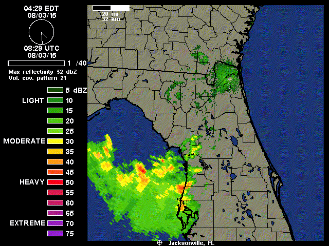
Tampa
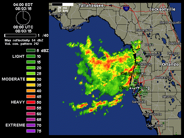
Jacksonville
Tampa
0 likes
M a r k
- - - - -
Join us in chat: Storm2K Chatroom Invite. Android and IOS apps also available.
The posts in this forum are NOT official forecasts and should not be used as such. Posts are NOT endorsed by any professional institution or STORM2K.org. For official information and forecasts, please refer to NHC and NWS products.
-
tolakram
- Admin
- Posts: 19165
- Age: 60
- Joined: Sun Aug 27, 2006 8:23 pm
- Location: Florence, KY (name is Mark)
Re: ATL: INVEST 95L - Discussion
0 likes
M a r k
- - - - -
Join us in chat: Storm2K Chatroom Invite. Android and IOS apps also available.
The posts in this forum are NOT official forecasts and should not be used as such. Posts are NOT endorsed by any professional institution or STORM2K.org. For official information and forecasts, please refer to NHC and NWS products.
- - - - -
Join us in chat: Storm2K Chatroom Invite. Android and IOS apps also available.
The posts in this forum are NOT official forecasts and should not be used as such. Posts are NOT endorsed by any professional institution or STORM2K.org. For official information and forecasts, please refer to NHC and NWS products.
Re: ATL: INVEST 95L - Discussion
Wow, highest convergence & UL divergence is right over Tampa Bay, glad I do not have to go to Tampa this week.
0 likes
-
cycloneye
- Admin
- Posts: 139060
- Age: 67
- Joined: Thu Oct 10, 2002 10:54 am
- Location: San Juan, Puerto Rico
Re: ATL: INVEST 95L - Discussion
Low is inland.
95L INVEST 150803 1200 30.0N 82.9W ATL 25 1008
95L INVEST 150803 1200 30.0N 82.9W ATL 25 1008
0 likes
Visit the Caribbean-Central America Weather Thread where you can find at first post web cams,radars
and observations from Caribbean basin members Click Here
and observations from Caribbean basin members Click Here
-
tolakram
- Admin
- Posts: 19165
- Age: 60
- Joined: Sun Aug 27, 2006 8:23 pm
- Location: Florence, KY (name is Mark)
Re: ATL: INVEST 95L - Discussion
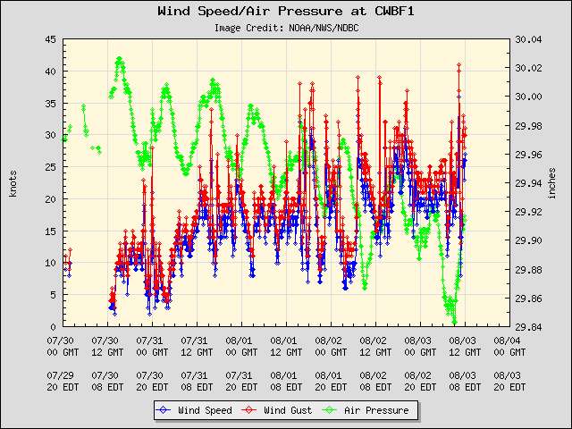
Station at Clearwater
0 likes
M a r k
- - - - -
Join us in chat: Storm2K Chatroom Invite. Android and IOS apps also available.
The posts in this forum are NOT official forecasts and should not be used as such. Posts are NOT endorsed by any professional institution or STORM2K.org. For official information and forecasts, please refer to NHC and NWS products.
- - - - -
Join us in chat: Storm2K Chatroom Invite. Android and IOS apps also available.
The posts in this forum are NOT official forecasts and should not be used as such. Posts are NOT endorsed by any professional institution or STORM2K.org. For official information and forecasts, please refer to NHC and NWS products.
-
northjaxpro
- S2K Supporter
- Posts: 8900
- Joined: Mon Sep 27, 2010 11:21 am
- Location: Jacksonville, FL
The actual durface Low looks to be between Gainesville and Cross City and is now drifting east-northeast. 95L should be exiting off the NE Florida/SE Georgia coast by late this afternoon or early evening. I am inclined to believe that 95L has a decent chance to become a TS or possibly a minimal hurricane once it moves off the SE U.S. coast as it heads northeast.
0 likes
NEVER, EVER SAY NEVER in the tropics and weather in general, and most importantly, with life itself!!
________________________________________________________________________________________
Fay 2008 Beryl 2012 Debby 2012 Colin 2016 Hermine 2016 Julia 2016 Matthew 2016 Irma 2017 Dorian 2019
________________________________________________________________________________________
Fay 2008 Beryl 2012 Debby 2012 Colin 2016 Hermine 2016 Julia 2016 Matthew 2016 Irma 2017 Dorian 2019
-
TheStormExpert
- Category 5
- Posts: 8487
- Age: 30
- Joined: Wed Feb 16, 2011 5:38 pm
- Location: Palm Beach Gardens, FL
Re:
northjaxpro wrote:The actual durface Low looks to be between Gainesville and Cross City and is now drifting east-northeast. 95L should be exiting off the NE Florida/SE Georgia coast by late this afternoon or early evening. I am inclined to believe that 95L has a decent chance to become a TS or possibly a minimal hurricane once it moves off the SE U.S. coast as it heads northeast.
I guess it may have a chance to acquire a name once it gets out into the open Atlantic off the SE U.S. Coast IF shear cooperates this time. I'd put odds at maybe 10% like the NHC has no higher ATM.
0 likes
The following post is NOT an official forecast and should not be used as such. It is just the opinion of the poster and may or may not be backed by sound meteorological data. It is NOT endorsed by storm2k.org.
-
TheStormExpert
- Category 5
- Posts: 8487
- Age: 30
- Joined: Wed Feb 16, 2011 5:38 pm
- Location: Palm Beach Gardens, FL
Wind Shear may be an issue again once this emerges into the Atlantic off the SE U.S. Coast.


0 likes
The following post is NOT an official forecast and should not be used as such. It is just the opinion of the poster and may or may not be backed by sound meteorological data. It is NOT endorsed by storm2k.org.
-
gatorcane

- S2K Supporter
- Posts: 23499
- Age: 46
- Joined: Sun Mar 13, 2005 3:54 pm
- Location: Boca Raton, FL
Re:
psyclone wrote:Widespread flooding is ongoing with numerous roads impassable.
I have family still in the Tampa area (Palm Harbor actually, where you live). I was talking to my mom this morning and she has never seen this much rain in the Tampa area and she has lived in Pinellas County for 59 years. Unreal all the rain this system is producing.
0 likes
Who is online
Users browsing this forum: No registered users and 115 guests