ATL: DANNY - Models

Moderator: S2k Moderators

Message
Author
User avatar
WPBWeather
S2K Supporter
S2K Supporter
Posts: 535
Age: 65
Joined: Thu Jul 18, 2013 12:33 pm

Re: Re:

#801 Postby WPBWeather » Sat Aug 22, 2015 2:33 pm

Nope even the remants recurve well east of Florida suggesting big-time troughing over the Eastern United States. That same trough lingers around and picks up the wave behind Danny too sending it on a recurve (though too early to know for sure if the wave behind Danny will definitely recurve or not).[/quote]

http://kamala.cod.edu/fl/latest.fxus62.KMFL.html

LONG TERM (TUES-SAT)

MID AND UPPER TROUGH TAKES OVER MUCH OF THE EASTERN CONUS THROUGH
THE PERIOD. SURFACE LOW PRESSURE WILL DEVELOP OVER NE FL OR SE GA
WED AND THURS. IN RESPONSE, H5 TEMPS WILL COOL AND H7-H5 LAPSE RATES
WILL BECOME MORE FAVORABLE. SO STORMS WILL BE STRONGER THAN WHAT
WE'VE EXPERIENCED THIS PAST WEEK. HOWEVER, SURFACE HIGH PRESSURE
WILL HOLD ON ACROSS THE WESTERN ATLANTIC AND THE BAHAMAS FOR A
WHILE, SUCH THAT SURFACE FLOW DOES NOT VEER TO THE SW UNTIL LATE
WEEK, AND THEN PERHAPS ONLY BRIEFLY.[/quote]
:uarrow: so trough or no trough?
0 likes   

AutoPenalti
Category 5
Category 5
Posts: 3949
Age: 27
Joined: Mon Aug 17, 2015 4:16 pm
Location: Ft. Lauderdale, Florida

Re:

#802 Postby AutoPenalti » Sat Aug 22, 2015 2:35 pm

TheStormExpert wrote:And just like that the Semi-Permanent East Coast Trough is back. What a surprise. :roll:

What does that mean exactly?
0 likes   
The posts in this forum are NOT official forecasts and should not be used as such. They are just the opinion of the poster and may or may not be backed by sound meteorological data. They are NOT endorsed by any professional institution or STORM2K. For official information, please refer to products from the NHC and NWS.


Model Runs Cheat Sheet:
GFS (5:30 AM/PM, 11:30 AM/PM)
HWRF, GFDL, UKMET, NAVGEM (6:30-8:00 AM/PM, 12:30-2:00 AM/PM)
ECMWF (1:45 AM/PM)

TCVN
is a weighted averaged

NCSTORMMAN

Re: Re:

#803 Postby NCSTORMMAN » Sat Aug 22, 2015 2:38 pm

AutoPenalti wrote:
TheStormExpert wrote:And just like that the Semi-Permanent East Coast Trough is back. What a surprise. :roll:

What does that mean exactly?


That magic trough is coming through to scoop up Danny and his buddies the rest of the season out to sea. The US has been extra lucky lately. In El Nino seasons and not in El Nino seasons. A very good thing no doubt. I still think that lack of tropical moisture we usually get though is causing the droughts going on in the Carolinas and deep south.
Last edited by NCSTORMMAN on Sat Aug 22, 2015 2:38 pm, edited 1 time in total.
0 likes   

User avatar
TheStormExpert
Category 5
Category 5
Posts: 8487
Age: 30
Joined: Wed Feb 16, 2011 5:38 pm
Location: Palm Beach Gardens, FL

#804 Postby TheStormExpert » Sat Aug 22, 2015 2:38 pm

18z Guidance trending fishy!
:fishing:

18z Model Guidance :darrow:

Image

18z Intensity Guidance :darrow:

Image
0 likes   
The following post is NOT an official forecast and should not be used as such. It is just the opinion of the poster and may or may not be backed by sound meteorological data. It is NOT endorsed by storm2k.org.

User avatar
TheStormExpert
Category 5
Category 5
Posts: 8487
Age: 30
Joined: Wed Feb 16, 2011 5:38 pm
Location: Palm Beach Gardens, FL

Re: Re:

#805 Postby TheStormExpert » Sat Aug 22, 2015 2:41 pm

NCSTORMMAN wrote:
AutoPenalti wrote:
TheStormExpert wrote:And just like that the Semi-Permanent East Coast Trough is back. What a surprise. :roll:

What does that mean exactly?


That magic trough is coming through to scoop up Danny and his buddies the rest of the season out to sea. The US has been extra lucky lately. In El Nino seasons and not in El Nino seasons. A very good thing no doubt. I still think that lack of tropical moisture we usually get though is causing the droughts going on in the Carolinas and deep south.

Not saying I want a U.S. threat at all, just find it always weird how the trough arrives in time to recurve these storms/hurricane. Unfortunately I would think our luck will run out one of these years.
0 likes   
The following post is NOT an official forecast and should not be used as such. It is just the opinion of the poster and may or may not be backed by sound meteorological data. It is NOT endorsed by storm2k.org.

NCSTORMMAN

Re: Re:

#806 Postby NCSTORMMAN » Sat Aug 22, 2015 2:43 pm

It is just magical. First time in recorded weather history a length of time like this in the US without a major making landfall. It is weird to say the least but of course a very very good thing.
0 likes   

AutoPenalti
Category 5
Category 5
Posts: 3949
Age: 27
Joined: Mon Aug 17, 2015 4:16 pm
Location: Ft. Lauderdale, Florida

#807 Postby AutoPenalti » Sat Aug 22, 2015 2:56 pm

Or just a pure extreme coincidence.
0 likes   
The posts in this forum are NOT official forecasts and should not be used as such. They are just the opinion of the poster and may or may not be backed by sound meteorological data. They are NOT endorsed by any professional institution or STORM2K. For official information, please refer to products from the NHC and NWS.


Model Runs Cheat Sheet:
GFS (5:30 AM/PM, 11:30 AM/PM)
HWRF, GFDL, UKMET, NAVGEM (6:30-8:00 AM/PM, 12:30-2:00 AM/PM)
ECMWF (1:45 AM/PM)

TCVN
is a weighted averaged

hurricaneCW
Category 5
Category 5
Posts: 1773
Joined: Wed Mar 03, 2010 6:20 am
Location: Toms River, NJ

Re: ATL: DANNY - Models

#808 Postby hurricaneCW » Sat Aug 22, 2015 3:07 pm

Extremely premature posts about the weather pattern over a week from now. And yes Danny may not even exist anyway.
0 likes   

jlauderdal
S2K Supporter
S2K Supporter
Posts: 6771
Joined: Wed May 19, 2004 5:46 am
Location: NE Fort Lauderdale
Contact:

Re: ATL: DANNY - Models

#809 Postby jlauderdal » Sat Aug 22, 2015 3:11 pm

hurricaneCW wrote:Extremely premature posts about the weather pattern over a week from now. And yes Danny may not even exist anyway.


we discuss patterns 7 days out frequently...whats the prob with that? we also know the farther out in time the greater the error but as far as troughs and ridges at 7 days those are fairly easy to identify...the issue at 7 days is nailing down a hurricane location within 300 miles..that's different then overall pattern recognition
0 likes   

User avatar
TheStormExpert
Category 5
Category 5
Posts: 8487
Age: 30
Joined: Wed Feb 16, 2011 5:38 pm
Location: Palm Beach Gardens, FL

Re: ATL: DANNY - Models

#810 Postby TheStormExpert » Sat Aug 22, 2015 3:12 pm

hurricaneCW wrote:Extremely premature posts about the weather pattern over a week from now. And yes Danny may not even exist anyway.

How is it extremely premature when you have both now the GFS and Euro showing a deep trough 5-7 days out draped along the U.S. East Coast? I know models could change but this has been the normal pattern it seems for at least 6 years now it seems.
0 likes   
The following post is NOT an official forecast and should not be used as such. It is just the opinion of the poster and may or may not be backed by sound meteorological data. It is NOT endorsed by storm2k.org.

hurricaneCW
Category 5
Category 5
Posts: 1773
Joined: Wed Mar 03, 2010 6:20 am
Location: Toms River, NJ

Re: ATL: DANNY - Models

#811 Postby hurricaneCW » Sat Aug 22, 2015 3:14 pm

There's nothing wrong with discussing the upcoming pattern but a lot of absolutes are being thrown out. Sometimes it can get as ridiculous as that massive tracking map for Danny spanning the entire western Atlantic.

And troughing has greatly underperformed so far in the east. However we are seeing a NAO flip though correlations are still weak given its August.
Last edited by hurricaneCW on Sat Aug 22, 2015 3:17 pm, edited 1 time in total.
0 likes   

SeGaBob

#812 Postby SeGaBob » Sat Aug 22, 2015 3:17 pm

This is a pretty much a guaranteed recurve scenario, and probably the system behind it will do the same thing. Once the models start hinting at a recurve, they always find a way to turn. (I know it could change but it usually doesn't)
It's kind of depressing when you need rain.


Personal Forecast Disclaimer:
The posts in this forum are NOT official forecast and should not be used as such. They are just the opinion of the poster and may or may not be backed by sound meteorological data. They are NOT endorsed by any professional institution or storm2k.org. For official information, please refer to the NHC and NWS products.
0 likes   

User avatar
CourierPR
Category 5
Category 5
Posts: 1325
Age: 70
Joined: Tue Aug 31, 2004 7:53 pm
Location: Pompano Beach, Florida

Re: ATL: DANNY - Models

#813 Postby CourierPR » Sat Aug 22, 2015 3:21 pm

hurricaneCW wrote:There's nothing wrong with discussing the upcoming pattern but a lot of absolutes are being thrown out. Sometimes it can get as ridiculous as that massive tracking map for Danny spanning the entire western Atlantic.

And troughing has greatly underperformed so far in the east. However we are seeing a NAO flip though correlations are still weak given its August.


Weren't those very same models showing strong ridging a few days ago?
0 likes   

hurricaneCW
Category 5
Category 5
Posts: 1773
Joined: Wed Mar 03, 2010 6:20 am
Location: Toms River, NJ

Re: ATL: DANNY - Models

#814 Postby hurricaneCW » Sat Aug 22, 2015 3:26 pm

Weren't those very same models showing strong ridging a few days ago?[/quote]

I believe they did partially. There were some notable difference between the gfs and euro however. In my opinion, Danny may not even survive; it's already falling apart quickly. It's the next wave that might be a bigger player down the line.
0 likes   

jlauderdal
S2K Supporter
S2K Supporter
Posts: 6771
Joined: Wed May 19, 2004 5:46 am
Location: NE Fort Lauderdale
Contact:

Re: ATL: DANNY - Models

#815 Postby jlauderdal » Sat Aug 22, 2015 3:52 pm

hurricaneCW wrote:Weren't those very same models showing strong ridging a few days ago?


I believe they did partially. There were some notable difference between the gfs and euro however. In my opinion, Danny may not even survive; it's already falling apart quickly. It's the next wave that might be a bigger player down the line.[/quote]

the next one recurves too..troughing in play..god for sofla..we need the tstorms heading our direction instead of west coast..havent heard thunder here in over 10 days
0 likes   

User avatar
gatorcane
S2K Supporter
S2K Supporter
Posts: 23499
Age: 46
Joined: Sun Mar 13, 2005 3:54 pm
Location: Boca Raton, FL

#816 Postby gatorcane » Sat Aug 22, 2015 5:35 pm

18Z GFS takes whatever is left of Danny into the FL straits this run instead of recurving the remnants east of Florida. Seems to have shifted more to the left and showing a stronger 700MB ridge than the 12Z. But there is a ton of shear waiting for Danny over the FL Straits and Florida should he get any ideas!
0 likes   

User avatar
TheStormExpert
Category 5
Category 5
Posts: 8487
Age: 30
Joined: Wed Feb 16, 2011 5:38 pm
Location: Palm Beach Gardens, FL

Re:

#817 Postby TheStormExpert » Sat Aug 22, 2015 5:42 pm

gatorcane wrote:18Z GFS takes whatever is left of Danny into the FL straits this run instead of recurving the remnants east of Florida. Seems to have shifted more to the left and showing a stronger 700MB ridge than the 12Z. But there is a ton of shear waiting for Danny over the FL Straits and Florida should he get any ideas!

What about in the Bahamas region?
0 likes   
The following post is NOT an official forecast and should not be used as such. It is just the opinion of the poster and may or may not be backed by sound meteorological data. It is NOT endorsed by storm2k.org.

tolakram
Admin
Admin
Posts: 19165
Age: 60
Joined: Sun Aug 27, 2006 8:23 pm
Location: Florence, KY (name is Mark)

Re: ATL: DANNY - Models

#818 Postby tolakram » Sat Aug 22, 2015 6:58 pm

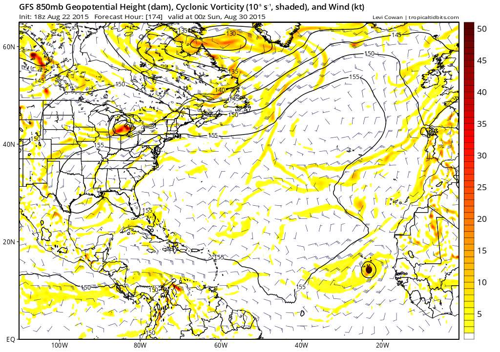
18Z GFS takes vorticity over Cuba and dissipates it. Similar to an older run.

The little patch of yellow on the NW coast of Cuba is all that's left. Long range, unreliable, for what it's worth.

Image
0 likes   
M a r k
- - - - -
Join us in chat: Storm2K Chatroom Invite. Android and IOS apps also available.

The posts in this forum are NOT official forecasts and should not be used as such. Posts are NOT endorsed by any professional institution or STORM2K.org. For official information and forecasts, please refer to NHC and NWS products.

User avatar
TheStormExpert
Category 5
Category 5
Posts: 8487
Age: 30
Joined: Wed Feb 16, 2011 5:38 pm
Location: Palm Beach Gardens, FL

#819 Postby TheStormExpert » Sat Aug 22, 2015 7:53 pm

00z Track Guidance :darrow:

Image

00z Intensity Guidance :darrow:

Image
0 likes   
The following post is NOT an official forecast and should not be used as such. It is just the opinion of the poster and may or may not be backed by sound meteorological data. It is NOT endorsed by storm2k.org.

YoshiMike
Tropical Storm
Tropical Storm
Posts: 106
Age: 28
Joined: Wed Aug 27, 2014 9:18 pm
Location: Hattiesburg, MS
Contact:

#820 Postby YoshiMike » Sun Aug 23, 2015 2:08 am

Lol one of the models has it going back up to category 4 :P a lot of the models have it restrengthening just a little bit but by the looks of how things are going currently I don't think that may happen in my own personal opinion
0 likes   
Okay guys, just because I want to BE a meteorologist, want to go to school for meteorology, DOES NOT MAKE ME A METEOROLOGIST. Anything I say about tropical weather is either me learning something new, or is just an opinion and nothing more than that. I can almost guarantee you that I will be wrong about pretty much everything.


Return to “2015”

Who is online

Users browsing this forum: No registered users and 116 guests