ATL: INVEST 99L - Discussion

Moderator: S2k Moderators

Message
Author
Weatherwatcher98
Category 1
Category 1
Posts: 346
Joined: Sat Sep 12, 2015 10:53 am

Re: ATL: INVEST 99L - Discussion

#201 Postby Weatherwatcher98 » Mon Sep 28, 2015 11:15 am

stormlover2013 wrote:guys because its close to home thats why, lets just be realistic here the most we can get out of this is a weak weak weak trop storm but this will just be rain, so just deal with it, I don't know why people get bad when they say something isn't going to develop, the thing looks like a sheared mess......lets just all use common sense here.....everyone should get along let hope florida doesn't get to much rain with the recent floods

Not giving anyone any grief just trying to learn in this forum and give some feedback oh and I am a weather nerd. I thought that is what this board was for. I guess I will go back to lurking and keeping my thoughts and questions to myself :(
0 likes   
Personal Forecast Disclaimer:
The posts in this forum are NOT official forecast and should not be used as such. They are just the opinion of the poster and may or may not be backed by sound meteorological data. They are NOT endorsed by any professional institution or storm2k.org. For official information, please refer to the NHC and NWS products.

User avatar
Extratropical94
Professional-Met
Professional-Met
Posts: 3535
Age: 29
Joined: Wed Oct 20, 2010 6:36 am
Location: Hamburg, Germany
Contact:

Re: ATL: INVEST 99L - Discussion

#202 Postby Extratropical94 » Mon Sep 28, 2015 11:20 am

Weatherwatcher98 wrote:Recon Scheduled for tomorrow as well. If this has no chance why??


I guess the missions are tasked so in case something develops they have the staff and the aircraft ready for departure. It's easier and also less expensive to schedule something and then cancel it than trying to start a mission from scratch with no one informed and prepared.
0 likes   
54° 11' 59'' N, 9° 9' 20'' E
Boomer Sooner!
Go Broncos! Go Cards! Go Niners!
- Daniel

caneman
Category 5
Category 5
Posts: 1178
Joined: Fri Sep 05, 2014 5:44 am
Location: Clearwater Beach, Fl

#203 Postby caneman » Mon Sep 28, 2015 11:21 am

25 and 86 looks suspect to me. Well see what the 2 o'clock update says.
0 likes   

User avatar
wxman57
Moderator-Pro Met
Moderator-Pro Met
Posts: 22480
Age: 66
Joined: Sat Jun 21, 2003 8:06 pm
Location: Houston, TX (southwest)

Re: ATL: INVEST 99L - Discussion

#204 Postby wxman57 » Mon Sep 28, 2015 11:27 am

There won't be any recon tomorrow, as it will be inland by this time tomorrow. There's nothing out there now, not even the weak swirl that was evident yesterday. Nothing to see here, folks, move along... ;-)
0 likes   

User avatar
tropicwatch
Category 5
Category 5
Posts: 3205
Age: 60
Joined: Sat Jun 02, 2007 10:01 am
Location: Panama City Florida
Contact:

#205 Postby tropicwatch » Mon Sep 28, 2015 11:30 am

:uarrow: Not weak minded, may the force be with you 8-)
0 likes   
Tropicwatch


Agnes 72', Eloise 75, Elena 85', Kate 85', Charley 86', Florence 88', Beryl 94', Dean 95', Erin 95', Opal 95', Earl 98', Georges 98', Ivan 2004', Arlene 2005', Dennis 2005', Ida 2009' Debby 2012' Irma 2017' Michael 2018'

User avatar
NDG
S2K Supporter
S2K Supporter
Posts: 14933
Joined: Sun Jul 09, 2006 10:14 pm
Location: Orlando, FL

Re: ATL: INVEST 99L - Discussion

#206 Postby NDG » Mon Sep 28, 2015 11:32 am

wxman57 wrote:There won't be any recon tomorrow, as it will be inland by this time tomorrow. There's nothing out there now, not even the weak swirl that was evident yesterday. Nothing to see here, folks, move along... ;-)


Hopefully you will not get insulted like I was this morning ;)
0 likes   

caneman
Category 5
Category 5
Posts: 1178
Joined: Fri Sep 05, 2014 5:44 am
Location: Clearwater Beach, Fl

#207 Postby caneman » Mon Sep 28, 2015 11:36 am

YoU weren't insulted by me ndg nor anyone else from what I could tell. You insisted there wasn't an llc and there was. Plain and simple and was verified by nhc. No one said it was going to develop. But, on a positive note, you did say it wasnt going to develop early on. So 1 for 2, not bad :wink: Wxman57, are you calling for bones?
Last edited by caneman on Mon Sep 28, 2015 11:48 am, edited 2 times in total.
0 likes   

User avatar
NDG
S2K Supporter
S2K Supporter
Posts: 14933
Joined: Sun Jul 09, 2006 10:14 pm
Location: Orlando, FL

#208 Postby NDG » Mon Sep 28, 2015 11:40 am

Image
0 likes   

User avatar
tropicwatch
Category 5
Category 5
Posts: 3205
Age: 60
Joined: Sat Jun 02, 2007 10:01 am
Location: Panama City Florida
Contact:

#209 Postby tropicwatch » Mon Sep 28, 2015 11:51 am

Well the Hurricane Hunters are on their way. We shall soon see what 99L is all about.
0 likes   
Tropicwatch


Agnes 72', Eloise 75, Elena 85', Kate 85', Charley 86', Florence 88', Beryl 94', Dean 95', Erin 95', Opal 95', Earl 98', Georges 98', Ivan 2004', Arlene 2005', Dennis 2005', Ida 2009' Debby 2012' Irma 2017' Michael 2018'

User avatar
drezee
S2K Supporter
S2K Supporter
Posts: 3643
Joined: Mon Jun 09, 2003 12:49 pm
Location: FL

Re: ATL: INVEST 99L - Discussion

#210 Postby drezee » Mon Sep 28, 2015 11:54 am

With all due respect, I have to differ with most opinions here. This is a complicated system indeed. To say there is no chance is almost laughable though. We have a surface convergence in the SW quad of an outflow jet. It would take very little from this to pop. I mean this setup can pop in 12 hours. We have seen it before. If you look closely, outflow is moving to the west and expanding. I would "not" write this thing off until it got onshore. We have enough buoys to tell us what is happening though. If it pops you will see the following things happen...

1. 42003 pressure would lower quickly and SW to SSW winds would prevail
2. Convection would pop within 150nm of the buoy to the NE
3. pressure readings would become lower in the Eastern GOM than the Western
4. SE winds would begin to consistently go above 25kts from the SE in the NE GOM
0 likes   

crimi481
Category 2
Category 2
Posts: 587
Joined: Thu Sep 09, 2004 4:47 pm

Re: ATL: INVEST 99L - Discussion

#211 Postby crimi481 » Mon Sep 28, 2015 12:00 pm

could be the low center moved east- tucking under highest tops

http://www.ssd.noaa.gov/goes/east/gmex/flash-bd.html
0 likes   

User avatar
drezee
S2K Supporter
S2K Supporter
Posts: 3643
Joined: Mon Jun 09, 2003 12:49 pm
Location: FL

#212 Postby drezee » Mon Sep 28, 2015 12:05 pm

BTW, you are starting to see lightning down there near 42003...

http://www.lightningmaps.org/realtime
0 likes   

User avatar
NDG
S2K Supporter
S2K Supporter
Posts: 14933
Joined: Sun Jul 09, 2006 10:14 pm
Location: Orlando, FL

#213 Postby NDG » Mon Sep 28, 2015 12:07 pm

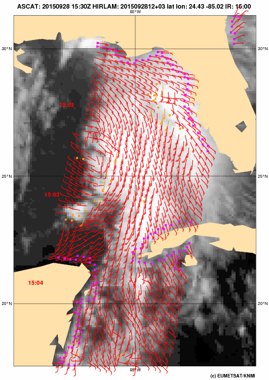
ASCAT from a couple hours ago shows that the circulation remains weak and elongated south to north, near 26N and 86.8W, closed.

Image
0 likes   

User avatar
ronjon
Category 5
Category 5
Posts: 4671
Joined: Fri Aug 19, 2005 5:17 pm
Location: Hernando Beach, FL

Re: ATL: INVEST 99L - Discussion

#214 Postby ronjon » Mon Sep 28, 2015 12:10 pm

Weatherwatcher98 wrote:
stormlover2013 wrote:guys because its close to home thats why, lets just be realistic here the most we can get out of this is a weak weak weak trop storm but this will just be rain, so just deal with it, I don't know why people get bad when they say something isn't going to develop, the thing looks like a sheared mess......lets just all use common sense here.....everyone should get along let hope florida doesn't get to much rain with the recent floods

Not giving anyone any grief just trying to learn in this forum and give some feedback oh and I am a weather nerd. I thought that is what this board was for. I guess I will go back to lurking and keeping my thoughts and questions to myself :(


Weatherwatcher98 - don't get discouraged. Please keep posting. You've posted some good observations.
0 likes   

User avatar
ronjon
Category 5
Category 5
Posts: 4671
Joined: Fri Aug 19, 2005 5:17 pm
Location: Hernando Beach, FL

Re:

#215 Postby ronjon » Mon Sep 28, 2015 12:13 pm

drezee wrote:BTW, you are starting to see lightning down there near 42003...

http://www.lightningmaps.org/realtime


Cool site drezee! Didn't know it existed.
0 likes   

User avatar
ronjon
Category 5
Category 5
Posts: 4671
Joined: Fri Aug 19, 2005 5:17 pm
Location: Hernando Beach, FL

Re: ATL: INVEST 99L - Discussion

#216 Postby ronjon » Mon Sep 28, 2015 12:17 pm

Heavy storms marching toward St-Pete and Sarasota. Appears that NWS Tampa Bay's concern was justified in posting their flood watch.

http://radar.weather.gov/radar.php?rid=TBW&product=N0R&overlay=11101111&loop=yes
0 likes   

otowntiger
Category 5
Category 5
Posts: 1787
Joined: Tue Aug 31, 2004 7:06 pm
Location: Orlando

Re: ATL: INVEST 99L - Discussion

#217 Postby otowntiger » Mon Sep 28, 2015 12:49 pm

Looks like the bulk of the heavy stuff may stay off shore. But I could be wrong.

I'm no meteorologist, don't make plans based on my observations. :wink:
0 likes   

User avatar
NDG
S2K Supporter
S2K Supporter
Posts: 14933
Joined: Sun Jul 09, 2006 10:14 pm
Location: Orlando, FL

#218 Postby NDG » Mon Sep 28, 2015 12:50 pm

So far recon is finding SSW winds west of the vorticity.
0 likes   

User avatar
Hammy
Category 5
Category 5
Posts: 5594
Age: 40
Joined: Fri May 25, 2012 5:25 pm
Contact:

Re:

#219 Postby Hammy » Mon Sep 28, 2015 12:59 pm

NDG wrote:So far recon is finding SSW winds west of the vorticity.


Likely associated with the front--ASCAT showed a closed low but the northerly winds were in a fairly small area near and under the convection.
0 likes   
The above post is not official and should not be used as such. It is the opinion of the poster and may or may not be backed by sound meteorological data. It is not endorsed by any professional institution or storm2k.org. For official information, please refer to the NHC and NWS products.

User avatar
NDG
S2K Supporter
S2K Supporter
Posts: 14933
Joined: Sun Jul 09, 2006 10:14 pm
Location: Orlando, FL

Re: Re:

#220 Postby NDG » Mon Sep 28, 2015 1:03 pm

Hammy wrote:
NDG wrote:So far recon is finding SSW winds west of the vorticity.


Likely associated with the front--ASCAT showed a closed low but the northerly winds were in a fairly small area near and under the convection.


I just realized that the recon is still flying at around 15k feet so those winds are at the mid levels, the plane has not descended yet.
0 likes   


Return to “2015”

Who is online

Users browsing this forum: No registered users and 43 guests