ATL: INVEST 92L - Discussion
Moderator: S2k Moderators
-
stormlover2013
- Category 5

- Posts: 2312
- Joined: Thu Aug 22, 2013 12:06 pm
- Location: Lumberton, Texas
Re: ATL: INVEST 92L - Discussion
we can all bring up climatology but this year pattern is different, throw climatology out, strong high pressure in the SE during this time and looks strong for next week also, all models showing something and they could all be wrong just have to see how all this plays out..
0 likes
-
Weatherwatcher98
- Category 1

- Posts: 346
- Joined: Sat Sep 12, 2015 10:53 am
Re: ATL: INVEST 92L - Discussion
That's possible. I am just curious how strong that high will be and if a Front comes down and grabs it. Thankswxman57 wrote:Weatherwatcher98 wrote:I agree way too far out but Climatology goes against west.wxman57 wrote:The ridge over the SE U.S. is building with each model run next week. That could push this system into Mexico. Euro and GFS are trending west. GFS now keeps it inland over MX/TX. 12Z Euro changed from SE LA to south of Lake Charles. Way too far out to have any confidence.
I wasn't suggesting it would move into the Gulf then turn west. It may track across the BoC into southern Mexico, with part of it becoming the TS south of the Gulf of Tehuantepec. Northern part may track north across Mexico to TX.
0 likes
Personal Forecast Disclaimer:
The posts in this forum are NOT official forecast and should not be used as such. They are just the opinion of the poster and may or may not be backed by sound meteorological data. They are NOT endorsed by any professional institution or storm2k.org. For official information, please refer to the NHC and NWS products.
The posts in this forum are NOT official forecast and should not be used as such. They are just the opinion of the poster and may or may not be backed by sound meteorological data. They are NOT endorsed by any professional institution or storm2k.org. For official information, please refer to the NHC and NWS products.
-
Weatherwatcher98
- Category 1
- Posts: 346
- Joined: Sat Sep 12, 2015 10:53 am
Re: ATL: INVEST 92L - Discussion
I see your point, but it is early in the game models will change. There is no COC to even track yet. High or no high, it's that time of year, and we had a front save us from Joaquin early this month. Very early for a front to move that far south. I just can't see how a front won't come down, and pick this up. Just my opinion.stormlover2013 wrote:we can all bring up climatology but this year pattern is different, throw climatology out, strong high pressure in the SE during this time and looks strong for next week also, all models showing something and they could all be wrong just have to see how all this plays out..
0 likes
Personal Forecast Disclaimer:
The posts in this forum are NOT official forecast and should not be used as such. They are just the opinion of the poster and may or may not be backed by sound meteorological data. They are NOT endorsed by any professional institution or storm2k.org. For official information, please refer to the NHC and NWS products.
The posts in this forum are NOT official forecast and should not be used as such. They are just the opinion of the poster and may or may not be backed by sound meteorological data. They are NOT endorsed by any professional institution or storm2k.org. For official information, please refer to the NHC and NWS products.
-
srainhoutx

- S2K Supporter

- Posts: 6919
- Age: 66
- Joined: Sun Jan 14, 2007 11:34 am
- Location: Haywood County, NC
- Contact:
Re: ATL: INVEST 92L - Discussion
Afternoon briefing from Jeff:
Potentially rare tropical system in the western Gulf of Mexico next week.
Yep it is mid October, but global forecast models are indicating the potential for a surface low pressure system to develop over the southwest/western Gulf of Mexico next week. This suggestion of tropical systems in the western Gulf has been highlighted a couple of times this hurricane season and thus far only Bill has resulted. Additionally, since 1851 only 1 tropical system has struck the state of Texas after October 16th…so any threat would be very rare. However…even if the calendar says October…the pattern is somewhat like September currently.
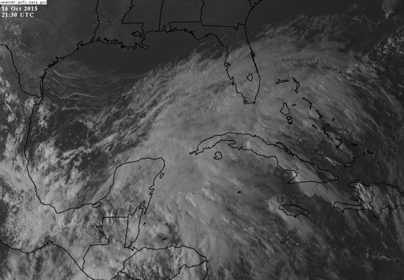
Two areas of disturbed weather are clearly noted on satellite images this afternoon with one over the SW Caribbean Sea and the other over the open Pacific waters south of the Mexican coast. The Pacific system appears well on its way to developing into a tropical system and will drift WNW then NW toward the coast over the weekend. The SW Caribbean Sea is elongated and moving inland over central America, but is expected to emerge in the southern Gulf of Mexico by late this weekend. Many times global models struggle with tropical development in this region and which side of Mexico the system forms and this may certainly be the case this time as well…but current observation suggest the Pacific system will develop first. Normally such systems would move westward, but this time of year with stronger troughs moving across the US, it is possible for such a system to be brought northward over MX and into the Gulf of Mexico on a rapid northward track. This seems at least possible next week given the formation of a deep layer trough over the SW US.
Another possible outcome is that a coastal trough forms over the western Gulf and never closes off into a closed surface low…that is not what the models are showing at the moment, but what has happened in the past this time of year.
For now will see what happens over the weekend…but feel rain chances will certainly rise significantly toward the middle of next week and remain high into next weekend. Will probably also need to watch tides starting early next week with sustained ENE flow and long fetch over the northern Gulf. Forecast confidence is fairly low given any tropical system passing inland to our west would bring much higher rainfall totals as well as other impacts while one passing to our east would result in lower rainfall chances. Much also depends on how any system might interact with the upper level trough to our west.
Potentially rare tropical system in the western Gulf of Mexico next week.
Yep it is mid October, but global forecast models are indicating the potential for a surface low pressure system to develop over the southwest/western Gulf of Mexico next week. This suggestion of tropical systems in the western Gulf has been highlighted a couple of times this hurricane season and thus far only Bill has resulted. Additionally, since 1851 only 1 tropical system has struck the state of Texas after October 16th…so any threat would be very rare. However…even if the calendar says October…the pattern is somewhat like September currently.
Two areas of disturbed weather are clearly noted on satellite images this afternoon with one over the SW Caribbean Sea and the other over the open Pacific waters south of the Mexican coast. The Pacific system appears well on its way to developing into a tropical system and will drift WNW then NW toward the coast over the weekend. The SW Caribbean Sea is elongated and moving inland over central America, but is expected to emerge in the southern Gulf of Mexico by late this weekend. Many times global models struggle with tropical development in this region and which side of Mexico the system forms and this may certainly be the case this time as well…but current observation suggest the Pacific system will develop first. Normally such systems would move westward, but this time of year with stronger troughs moving across the US, it is possible for such a system to be brought northward over MX and into the Gulf of Mexico on a rapid northward track. This seems at least possible next week given the formation of a deep layer trough over the SW US.
Another possible outcome is that a coastal trough forms over the western Gulf and never closes off into a closed surface low…that is not what the models are showing at the moment, but what has happened in the past this time of year.
For now will see what happens over the weekend…but feel rain chances will certainly rise significantly toward the middle of next week and remain high into next weekend. Will probably also need to watch tides starting early next week with sustained ENE flow and long fetch over the northern Gulf. Forecast confidence is fairly low given any tropical system passing inland to our west would bring much higher rainfall totals as well as other impacts while one passing to our east would result in lower rainfall chances. Much also depends on how any system might interact with the upper level trough to our west.
0 likes
Carla/Alicia/Jerry(In The Eye)/Michelle/Charley/Ivan/Dennis/Katrina/Rita/Wilma/Ike/Harvey
Member: National Weather Association
Wx Infinity Forums
http://wxinfinity.com/index.php
Facebook.com/WeatherInfinity
Twitter @WeatherInfinity
Member: National Weather Association
Wx Infinity Forums
http://wxinfinity.com/index.php
Facebook.com/WeatherInfinity
Twitter @WeatherInfinity
-
Weatherwatcher98
- Category 1
- Posts: 346
- Joined: Sat Sep 12, 2015 10:53 am
Re: ATL: INVEST 92L - Discussion
Interesting, he is going with the Pacific system.
0 likes
Personal Forecast Disclaimer:
The posts in this forum are NOT official forecast and should not be used as such. They are just the opinion of the poster and may or may not be backed by sound meteorological data. They are NOT endorsed by any professional institution or storm2k.org. For official information, please refer to the NHC and NWS products.
The posts in this forum are NOT official forecast and should not be used as such. They are just the opinion of the poster and may or may not be backed by sound meteorological data. They are NOT endorsed by any professional institution or storm2k.org. For official information, please refer to the NHC and NWS products.
Re: ATL: INVEST 92L - Discussion
Big monsoon trough-like feature. These sometimes develop at this time of year.
0 likes
-
floridasun78
- Category 5
- Posts: 3755
- Joined: Sun May 17, 2009 10:16 pm
- Location: miami fl

Re: ATL: INVEST 92L - Discussion
Wow, what a big monsoon trough, big rains from southern FL to most of Cuba down to the Yucatan and Central America. Development or no development in the GOM next week will bring lots of moisture into the south central US, much needed.
0 likes

Re: ATL: INVEST 92L - Discussion
IF a center develops east of Belize where the shear from that anticyclone is currently relaxed..
Then its possible the deeper layer steering currents will pull that energy into the BOC.
The current enormous monsoon would feed back into a developing system in a few days.
Then its possible the deeper layer steering currents will pull that energy into the BOC.
The current enormous monsoon would feed back into a developing system in a few days.
0 likes
-
cycloneye

- Admin

- Posts: 139051
- Age: 67
- Joined: Thu Oct 10, 2002 10:54 am
- Location: San Juan, Puerto Rico
Re: ATL: INVEST 92L - Discussion
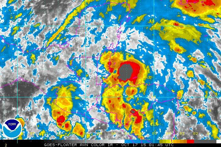
TROPICAL WEATHER OUTLOOK
NWS NATIONAL HURRICANE CENTER MIAMI FL
800 PM EDT FRI OCT 16 2015
For the North Atlantic...Caribbean Sea and the Gulf of Mexico:
A broad area of low pressure located over the Gulf of Honduras and
the adjacent land areas is producing a large area of cloudiness,
showers, and thunderstorms. Land interaction is expected to
preclude significant development of this system during the next day
or so while it moves slowly west-northwestward across the Yucatan
Peninsula. However, some limited development is possible on Sunday
or Monday if the system emerges into the Bay of Campeche. Regardless
of tropical cyclone formation, this system could produce heavy
rainfall across portions of Honduras, Belize, and the Yucatan
Peninsula through the weekend.
* Formation chance through 48 hours...low...10 percent
* Formation chance through 5 days...low...20 percent
$$
Forecaster Beven
0 likes
Visit the Caribbean-Central America Weather Thread where you can find at first post web cams,radars
and observations from Caribbean basin members Click Here
and observations from Caribbean basin members Click Here


-
MONTEGUT_LA

- Tropical Depression

- Posts: 87
- Joined: Sun Jul 20, 2003 7:29 pm
- Location: Montegut, Louisiana
Re: Re:
Weatherwatcher98 wrote:https://en.wikipedia.org/wiki/Hurricane_Juan_(1985)gatorcane wrote:EC shows a hurricane into Texas/LA border in the long-range
Has Texas/SW LA ever been hit by a hurricane this late?
Also In Louisiana, Hurricane Lili 2002
0 likes
::::::Danny & Juan '85, Andrew '92, Lili '02, Katrina & Rita '05, Gustav & Ike '08, Isaac '12, Ida 2021::::::
::::It's been a wild ride, but you just gotta love living on the gulf coast!::::
::::It's been a wild ride, but you just gotta love living on the gulf coast!::::

Re: ATL: INVEST 92L - Discussion
Hurricanes have hit Texas in October and even November.
Texas Hurricane History
http://www.wpc.ncep.noaa.gov/research/txhur.pdf
Texas Hurricane History
http://www.wpc.ncep.noaa.gov/research/txhur.pdf
0 likes
-
tatertawt24
- Category 1
- Posts: 309
- Joined: Wed Oct 24, 2012 12:57 pm
Re: ATL: INVEST 92L - Discussion
What is it with storms forming around the Yucatan in mid-October? 
0 likes
Personal Forecast Disclaimer:
The posts in this forum are NOT official forecast and should not be used as such. They are just the opinion of the poster and may or may not be backed by sound meteorological data. They are NOT endorsed by any professional institution or storm2k.org. For official information, please refer to the NHC and NWS products.
The posts in this forum are NOT official forecast and should not be used as such. They are just the opinion of the poster and may or may not be backed by sound meteorological data. They are NOT endorsed by any professional institution or storm2k.org. For official information, please refer to the NHC and NWS products.

I'm personally putting this at 0% for development. Models are trending further and further west (it's moved roughly 1000 miles west in the models since a few days ago) and that's with 5-6 days left for it to go even further.
0 likes
The above post is not official and should not be used as such. It is the opinion of the poster and may or may not be backed by sound meteorological data. It is not endorsed by any professional institution or storm2k.org. For official information, please refer to the NHC and NWS products.
-
Weatherwatcher98
- Category 1
- Posts: 346
- Joined: Sat Sep 12, 2015 10:53 am
Re: ATL: INVEST 92L - Discussion
I agree Hammy.
0 likes
Personal Forecast Disclaimer:
The posts in this forum are NOT official forecast and should not be used as such. They are just the opinion of the poster and may or may not be backed by sound meteorological data. They are NOT endorsed by any professional institution or storm2k.org. For official information, please refer to the NHC and NWS products.
The posts in this forum are NOT official forecast and should not be used as such. They are just the opinion of the poster and may or may not be backed by sound meteorological data. They are NOT endorsed by any professional institution or storm2k.org. For official information, please refer to the NHC and NWS products.
-
Weatherwatcher98
- Category 1
- Posts: 346
- Joined: Sat Sep 12, 2015 10:53 am
Re: ATL: INVEST 92L - Discussion
Ptarmigan wrote:Hurricanes have hit Texas in October and even November.
Texas Hurricane History
http://www.wpc.ncep.noaa.gov/research/txhur.pdf
Very rare situation. Has not happened again."November 5th, 1839: A hurricane struck Galveston unusually late in the year"
0 likes
Personal Forecast Disclaimer:
The posts in this forum are NOT official forecast and should not be used as such. They are just the opinion of the poster and may or may not be backed by sound meteorological data. They are NOT endorsed by any professional institution or storm2k.org. For official information, please refer to the NHC and NWS products.
The posts in this forum are NOT official forecast and should not be used as such. They are just the opinion of the poster and may or may not be backed by sound meteorological data. They are NOT endorsed by any professional institution or storm2k.org. For official information, please refer to the NHC and NWS products.
-
cycloneye
- Admin
- Posts: 139051
- Age: 67
- Joined: Thu Oct 10, 2002 10:54 am
- Location: San Juan, Puerto Rico
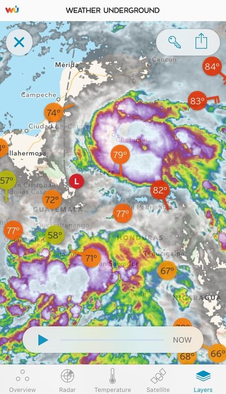
Re: ATL: INVEST 92L - Discussion
TROPICAL WEATHER OUTLOOK
NWS NATIONAL HURRICANE CENTER MIAMI FL
800 AM EDT SAT OCT 17 2015
For the North Atlantic...Caribbean Sea and the Gulf of Mexico:
An area of showers and thunderstorms extending from the northwestern
Caribbean Sea through the southern Yucatan peninsula is associated
with an area of low pressure located over central Belize. Land
interaction is expected to preclude significant development of this
system during the next day or so while it moves slowly west-
northwestward across the southern Yucatan peninsula. However, some
limited development is possible on Sunday or Monday if the low
emerges into the southern Bay of Campeche. Regardless of tropical
cyclone formation, this system will likely produce heavy rainfall
across portions of Honduras, Belize, northern Guatemala, and the
Yucatan Peninsula through Monday.
* Formation chance through 48 hours...low...10 percent
* Formation chance through 5 days...low...20 percent
$$
Forecaster Brennan/Kimberlain
0 likes
Visit the Caribbean-Central America Weather Thread where you can find at first post web cams,radars
and observations from Caribbean basin members Click Here
and observations from Caribbean basin members Click Here
Re: ATL: INVEST 92L - Discussion
Deep convection over the GOH this morning but the surface trough is inland over C.A. down to the EPAC. The huge surface high coming down the eastern US will push the convection even further south focusing the development over on the Pacific side. A combination between building mid level ridge over the GOM and an ULL over the SW US should pull the moisture northward towards the south central US. What I am seeing is that if the ridging over the central and eastern GOM builds stronger it will be hard for a tropical system to form from the energy from the EPAC, instead a frontal type low could end up forming near the MX/TX coast as shown lately by the GFS and Euro. But regardless much needed rains could be in tap for TX and LA, hopefully.

0 likes
Who is online
Users browsing this forum: No registered users and 42 guests