WPAC: INVEST 91W

Moderator: S2k Moderators

Message
Author
User avatar
cycloneye
Admin
Admin
Posts: 139019
Age: 67
Joined: Thu Oct 10, 2002 10:54 am
Location: San Juan, Puerto Rico

WPAC: INVEST 91W

#1 Postby cycloneye » Fri Jun 01, 2018 3:00 pm

Location: 10.2°N 148.3°E
Maximum Winds: 15 kt
Minimum Central Pressure: 1009 mb

Image

Image
0 likes   
Visit the Caribbean-Central America Weather Thread where you can find at first post web cams,radars
and observations from Caribbean basin members Click Here

User avatar
euro6208
Category 5
Category 5
Posts: 18547
Joined: Mon Mar 08, 2004 7:50 pm
Location: Guam

Re: WPAC: INVEST 91W

#2 Postby euro6208 » Fri Jun 01, 2018 7:05 pm

Heavy rains in the forecast for the Marianas.

Southwest to southerly flow associated with the upper high will
gradually stream moisture across Guam, Rota, Tinian and Saipan thru
tonight, increasing the chance of thunderstorms by later this evening.
Despite widespread convection flaring up near 90W this morning, it is
showing little signs of consolidation. Therefore, expect 90W, 91W and
their associated monsoon trough to remain quasi-stationary thru
tonight. On Sunday, there will be a better chance for 90W to become
better organized and start drifting north-northwestward parallel to
the Philippines. Under this scenario, the monsoon trough and 91W will
also lift slowly northward. Aided by abundant moisture, there is a
good chance for deep convection to fire up near 91W as it moves over
our local area Sunday and Monday. Periods of heavy showers and
thunderstorms are possible during the passage of 91W, future shifts
need to monitor this situation. Once northwest of our local area,
converging southeast winds in the wake of 91W should prolong unstable
conditions into midweek. If 90W develop further over the Philippine
Sea near midweek, a surface ridge should form to its southeast over
the Marianas and introduce quieter weather for the second half of the
week.
0 likes   
Remember, all of my post aren't official. For official warnings and discussions, Please refer to your local NWS products...

NWS for the Western Pacific

https://www.weather.gov/gum/

User avatar
cycloneye
Admin
Admin
Posts: 139019
Age: 67
Joined: Thu Oct 10, 2002 10:54 am
Location: San Juan, Puerto Rico

Re: WPAC: INVEST 91W

#3 Postby cycloneye » Fri Jun 01, 2018 7:43 pm

AN AREA OF CONVECTION (INVEST 91W) HAS PERSISTED NEAR
10.2N 148.2E, APPROXIMATELY 283 NM SOUTHEAST OF GUAM. ANIMATED
MULTISPECTRAL SATELLITE IMAGERY AND A 012148Z MHS 89GHZ MICROWAVE
IMAGE DEPICTS A DISORGANIZED LOW LEVEL CIRCULATION (LLC) WITH
SCATTERED CONVECTION. THE DISTURBANCE IS CURRENTLY LOCATED IN AN
AREA OF LOW TO MODERATE (10-20 KTS) VERTICAL WIND SHEAR AND WEAK
OUTFLOW ALOFT. WARM SEA SURFACE TEMPERATURES (28-29C) WILL SUPPORT
FURTHER DEVELOPMENT AS THE DISTURBANCE TRACKS NORTHERLY. GLOBAL
MODELS AGREE WITH THE GENERAL TRAJECTORY OF THE DISTURBANCE,
TRACKING NORTHERLY, BUT DISAGREE ON TIME AND INTENSITY MAXIMUM
SUSTAINED SURFACE WINDS ARE ESTIMATED AT 10 TO 15 KNOTS. MINIMUM SEA
LEVEL PRESSURE IS ESTIMATED TO BE NEAR 1009 MB. THE POTENTIAL FOR
THE DEVELOPMENT OF A SIGNIFICANT TROPICAL CYCLONE WITHIN THE NEXT 24
HOURS IS LOW.
0 likes   
Visit the Caribbean-Central America Weather Thread where you can find at first post web cams,radars
and observations from Caribbean basin members Click Here

User avatar
euro6208
Category 5
Category 5
Posts: 18547
Joined: Mon Mar 08, 2004 7:50 pm
Location: Guam

Re: WPAC: INVEST 91W

#4 Postby euro6208 » Fri Jun 01, 2018 8:41 pm

EURO and GFS has some type of interaction with 90W to the west. No significant intensification at this time.
0 likes   
Remember, all of my post aren't official. For official warnings and discussions, Please refer to your local NWS products...

NWS for the Western Pacific

https://www.weather.gov/gum/

User avatar
cycloneye
Admin
Admin
Posts: 139019
Age: 67
Joined: Thu Oct 10, 2002 10:54 am
Location: San Juan, Puerto Rico

Re: WPAC: INVEST 91W

#5 Postby cycloneye » Fri Jun 01, 2018 9:15 pm

Location: 10.6°N 147.4°E
Maximum Winds: 15 kt
Minimum Central Pressure: 1008 mb

Image
0 likes   
Visit the Caribbean-Central America Weather Thread where you can find at first post web cams,radars
and observations from Caribbean basin members Click Here

User avatar
euro6208
Category 5
Category 5
Posts: 18547
Joined: Mon Mar 08, 2004 7:50 pm
Location: Guam

Re: WPAC: INVEST 91W

#6 Postby euro6208 » Sat Jun 02, 2018 4:51 am

AN AREA OF CONVECTION (INVEST 91W) PREVIOUSLY LOCATED NEAR
10.2N 148.2E, IS NOW LOCATED NEAR 10.6N 147.4E, APPROXIMATELY 225 NM
SOUTHEAST OF GUAM. ANIMATED MULTISPECTRAL SATELLITE IMAGERY DISPLAYS
FLARING CONVECTION SURROUNDING THE LOW LEVEL CIRCULATION (LLC) WHILE
A 012357Z AMSU METOP-A 89GHZ MICROWAVE IMAGE DEPICTS A DISORGANIZED
SYSTEM. THE DISTURBANCE IS CURRENTLY LOCATED IN AN AREA OF LOW TO
MODERATE (10-20 KTS) VERTICAL WIND SHEAR AND WEAK OUTFLOW ALOFT.
WARM SEA SURFACE TEMPERATURES (28-29C) SUPPORT DEVELOPMENT AS THE
DISTURBANCE TRACKS NORTHERLY. GLOBAL MODELS INDICATE WEAK
DEVELOPMENT AS THE SYSTEM MOVES TO THE NORTHWEST BUT DISAGREE ON THE
OVERALL INTENSIFICATION OF THE SYSTEM. MAXIMUM SUSTAINED SURFACE
WINDS ARE ESTIMATED AT 10 TO 15 KNOTS. MINIMUM SEA LEVEL PRESSURE IS
ESTIMATED TO BE NEAR 1008 MB. THE POTENTIAL FOR THE DEVELOPMENT OF A
SIGNIFICANT TROPICAL CYCLONE WITHIN THE NEXT 24 HOURS REMAINS LOW.
0 likes   
Remember, all of my post aren't official. For official warnings and discussions, Please refer to your local NWS products...

NWS for the Western Pacific

https://www.weather.gov/gum/

User avatar
euro6208
Category 5
Category 5
Posts: 18547
Joined: Mon Mar 08, 2004 7:50 pm
Location: Guam

Re: WPAC: INVEST 91W

#7 Postby euro6208 » Sat Jun 02, 2018 6:13 am

Image

Very impressive circulation and bandings evident. Sleeper?
0 likes   
Remember, all of my post aren't official. For official warnings and discussions, Please refer to your local NWS products...

NWS for the Western Pacific

https://www.weather.gov/gum/

User avatar
euro6208
Category 5
Category 5
Posts: 18547
Joined: Mon Mar 08, 2004 7:50 pm
Location: Guam

Re: WPAC: INVEST 91W

#8 Postby euro6208 » Sun Jun 03, 2018 5:57 am

Image

AN AREA OF CONVECTION (INVEST 91W) PREVIOUSLY LOCATED NEAR
10.6N 147.4E, IS NOW LOCATED NEAR 11.3N 145.4E, APPROXIMATELY 135 NM
SOUTH-SOUTHEAST OF GUAM. ANIMATED MULTISPECTRAL SATELLITE IMAGERY
DISPLAYS A DISORGANIZED SYSTEM WITH FLARING CONVECTION OVER THE LOW
LEVEL CIRCULATION (LLC) WHILE A 030036Z MHS METOP-B 89GHZ MICROWAVE
IMAGE SUPPORTS THE DISORGANIZED CONVECTION SURROUNDING THE LLC. THE
DISTURBANCE IS CURRENTLY LOCATED IN AN AREA OF LOW TO MODERATE (10-
20 KTS) VERTICAL WIND SHEAR AND WEAK OUTFLOW ALOFT. WARM SEA SURFACE
TEMPERATURES (28-29C) SUPPORT DEVELOPMENT. GLOBAL MODELS INDICATE
WEAK DEVELOPMENT AS THE SYSTEM MOVES TO THE NORTHWEST BUT DISAGREE
ON THE OVERALL INTENSIFICATION OF THE SYSTEM. MAXIMUM SUSTAINED
SURFACE WINDS ARE ESTIMATED AT 10 TO 15 KNOTS. MINIMUM SEA LEVEL
PRESSURE IS ESTIMATED TO BE NEAR 1010 MB. THE POTENTIAL FOR THE
DEVELOPMENT OF A SIGNIFICANT TROPICAL CYCLONE WITHIN THE NEXT 24
HOURS REMAINS LOW.
0 likes   
Remember, all of my post aren't official. For official warnings and discussions, Please refer to your local NWS products...

NWS for the Western Pacific

https://www.weather.gov/gum/

User avatar
euro6208
Category 5
Category 5
Posts: 18547
Joined: Mon Mar 08, 2004 7:50 pm
Location: Guam

Re: WPAC: INVEST 91W

#9 Postby euro6208 » Sun Jun 03, 2018 6:17 am

Image

This place is a huge mess. EURO and GFS liking an interaction with 90W and eventually this wins out. No significant strengthening expected.
0 likes   
Remember, all of my post aren't official. For official warnings and discussions, Please refer to your local NWS products...

NWS for the Western Pacific

https://www.weather.gov/gum/

User avatar
euro6208
Category 5
Category 5
Posts: 18547
Joined: Mon Mar 08, 2004 7:50 pm
Location: Guam

Re: WPAC: INVEST 91W

#10 Postby euro6208 » Sun Jun 03, 2018 4:35 pm

THE AREA OF CONVECTION (INVEST 91W) PREVIOUSLY LOCATED
NEAR 11.3N 145.4E, IS NOW LOCATED NEAR 12.0N 142.6E, APPROXIMATELY
150 NM SOUTHWEST OF GUAM. ANIMATED ENHANCED INFRARED SATELLITE
IMAGERY AND A 031810Z SSMIS 91GHZ IMAGE DEPICT A SLOWLY
CONSOLIDATING LOW LEVEL CIRCULATION CENTER (LLCC) WITH PERSISTENT
DEEP CONVECTION. UPPER LEVEL ANALYSIS SHOWS THE DISTURBANCE IS
LOCATED IN AN AREA OF LOW TO MODERATE (10-20 KTS) VERTICAL WIND
SHEAR WITH DUAL OUTFLOW ALOFT. WARM SEA SURFACE TEMPERATURES (28-
29C) WILL SUPPORT DEVELOPMENT OVER THE 48-72 HOURS. GLOBAL MODELS
AGREE THAT 91W WILL TAKE A NORTHWESTERLY TRAJECTORY OVER THE NEXT
48HOURS, BUT DISAGREE ON THE TIMING AND INTENSITY. MAXIMUM SUSTAINED
SURFACE WINDS ARE ESTIMATED AT 15 TO 20 KNOTS. MINIMUM SEA LEVEL
PRESSURE IS ESTIMATED TO BE NEAR 1008 MB. THE POTENTIAL FOR THE
DEVELOPMENT OF A SIGNIFICANT TROPICAL CYCLONE WITHIN THE NEXT 24
HOURS IS UPGRADED TO MEDIUM.
0 likes   
Remember, all of my post aren't official. For official warnings and discussions, Please refer to your local NWS products...

NWS for the Western Pacific

https://www.weather.gov/gum/

User avatar
euro6208
Category 5
Category 5
Posts: 18547
Joined: Mon Mar 08, 2004 7:50 pm
Location: Guam

Re: WPAC: INVEST 91W

#11 Postby euro6208 » Sun Jun 03, 2018 4:37 pm

Image
0 likes   
Remember, all of my post aren't official. For official warnings and discussions, Please refer to your local NWS products...

NWS for the Western Pacific

https://www.weather.gov/gum/

User avatar
euro6208
Category 5
Category 5
Posts: 18547
Joined: Mon Mar 08, 2004 7:50 pm
Location: Guam

Re: WPAC: INVEST 91W

#12 Postby euro6208 » Sun Jun 03, 2018 8:03 pm

TXPQ25 KNES 032157
TCSWNP

A. TROPICAL DISTURBANCE (91W)

B. 03/2030Z

C. 13.2N

D. 142.1E

E. THREE/HIMAWARI-8

F. T1.0/1.0/S0.0/18HRS

G. IR/EIR/SWIR

H. REMARKS...THE CENTER IS POSITIONED FARTHER TO THE NORTH BASED ON
03/1810Z SSMIS MICROWAVE PASS. THIS INTENSITY ESTIMATE WAS DERIVED USING
4 KM IR DATA. GREATER THAN 2/10 BANDING YIELDS A DT OF 1.0. MET AND PT
AGREE. FT IS BASED ON MET DUE TO THE BANDING FEATURES NOT BEING CLEAR CUT.

I. ADDL POSITIONS

NIL


...HOSLEY
0 likes   
Remember, all of my post aren't official. For official warnings and discussions, Please refer to your local NWS products...

NWS for the Western Pacific

https://www.weather.gov/gum/

User avatar
mrbagyo
Category 5
Category 5
Posts: 3614
Age: 31
Joined: Thu Apr 12, 2012 9:18 am
Location: 14.13N 120.98E
Contact:

Re: WPAC: INVEST 91W

#13 Postby mrbagyo » Sun Jun 03, 2018 10:36 pm

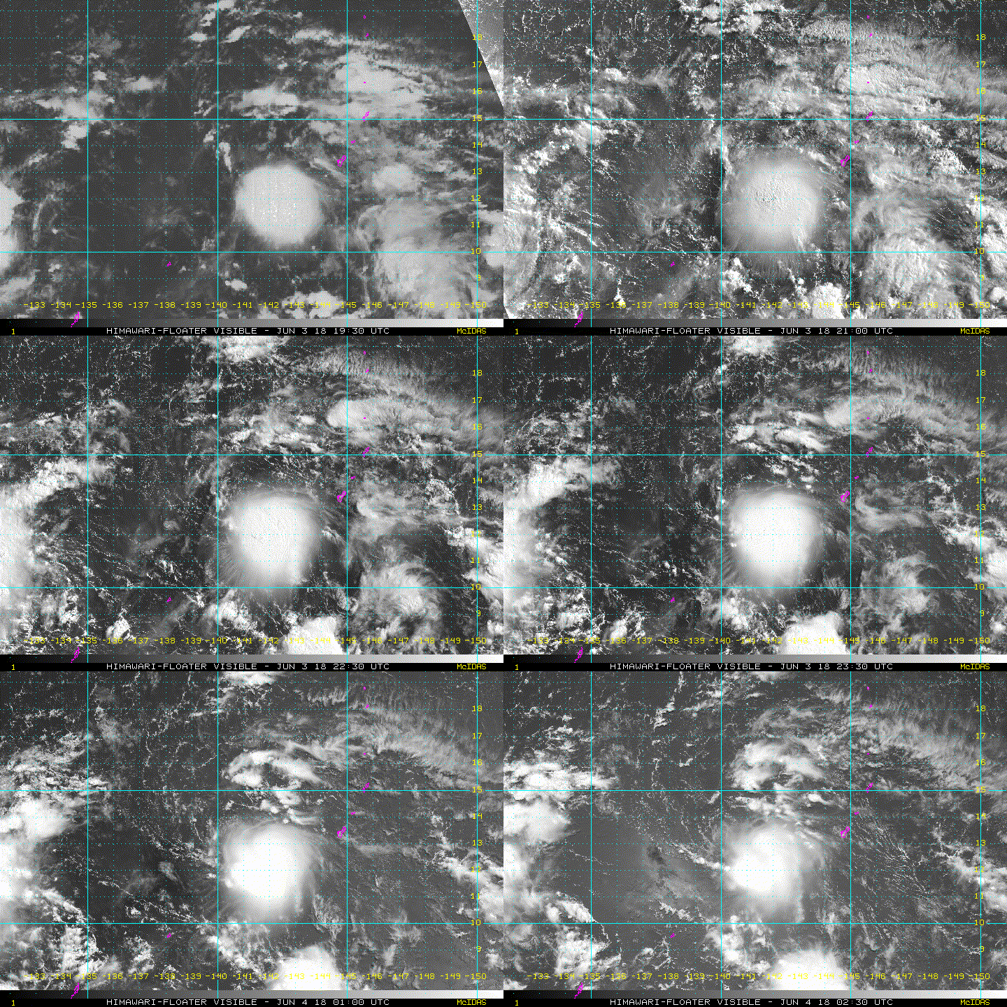
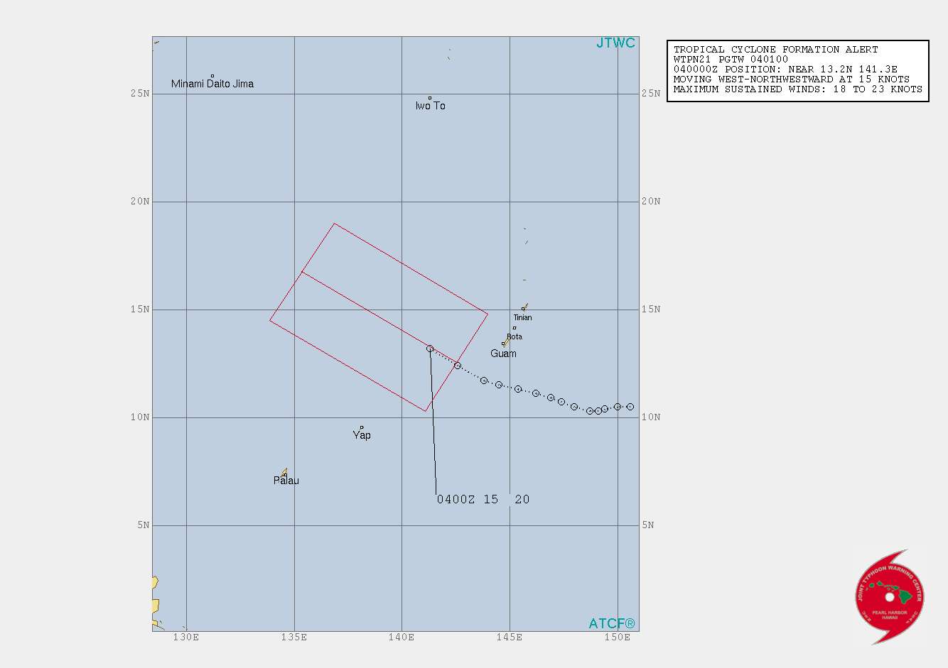
TCFA for this little booger

Image

Image

Image

WTPN21 PGTW 040100 MSGID/GENADMIN/JOINT TYPHOON WRNCEN PEARL HARBOR HI// SUBJ/TROPICAL CYCLONE FORMATION ALERT// RMKS/ 1. FORMATION OF A SIGNIFICANT TROPICAL CYCLONE IS POSSIBLE WITHIN 160 NM EITHER SIDE OF A LINE FROM 12.6N 142.5E TO 16.8N 135.4E WITHIN THE NEXT 12 TO 24 HOURS. AVAILABLE DATA DOES NOT JUSTIFY ISSUANCE OF NUMBERED TROPICAL CYCLONE WARNINGS AT THIS TIME. WINDS IN THE AREA ARE ESTIMATED TO BE 18 TO 23 KNOTS. METSAT IMAGERY AT 040000Z INDICATES THAT A CIRCULATION CENTER IS LOCATED NEAR 13.2N 141.3E. THE SYSTEM IS MOVING WEST-NORTHWESTWARD AT 15 KNOTS. 2. REMARKS: MAXIMUM SUSTAINED SURFACE WINDS ARE ESTIMATED AT 18 TO 23 KNOTS. MINIMUM SEA LEVEL PRESSURE IS ESTIMATED TO BE NEAR 1005 MB. THE POTENTIAL FOR THE DEVELOPMENT OF A SIGNIFICANT TROPICAL CYCLONE WITHIN THE NEXT 24 HOURS IS HIGH. 3. THIS ALERT WILL BE REISSUED, UPGRADED TO WARNING OR CANCELLED BY 050100Z.// NNNN
0 likes   
The posts in this forum are NOT official forecast and should not be used as such. They are just the opinion of the poster and may or may not be backed by sound meteorological data. They are NOT endorsed by any professional institution or storm2k.org. For official information, please refer to RSMC, NHC and NWS products.

User avatar
euro6208
Category 5
Category 5
Posts: 18547
Joined: Mon Mar 08, 2004 7:50 pm
Location: Guam

Re: WPAC: INVEST 91W

#14 Postby euro6208 » Mon Jun 04, 2018 12:26 am

TPPN11 PGTW 040308

A. TROPICAL DISTURBANCE 91W (SW OF GUAM)

B. 04/0250Z

C. 12.81N

D. 140.91E

E. FIVE/HMWRI8

F. T2.0/2.0/D0.5/24HRS STT: S0.0/03HRS

G. IR/EIR/VIS/MSI

H. REMARKS: 40A/PBO SBC/ANMTN. CNVCTN WRAPS .35 ON LOG10 SPIRAL
YIELDING A DT OF 2.0. MET AGREES. PT YIELDS 1.5. DBO DT.

I. ADDITIONAL POSITIONS:
03/2137Z 12.88N 141.72E SSMS
03/2305Z 13.05N 141.35E MMHS


VEERKAMP
0 likes   
Remember, all of my post aren't official. For official warnings and discussions, Please refer to your local NWS products...

NWS for the Western Pacific

https://www.weather.gov/gum/

User avatar
euro6208
Category 5
Category 5
Posts: 18547
Joined: Mon Mar 08, 2004 7:50 pm
Location: Guam

Re: WPAC: INVEST 91W

#15 Postby euro6208 » Mon Jun 04, 2018 12:28 am

151
WWMY80 PGUM 040308
SPSMY

Special Weather Statement
National Weather Service Tiyan GU
108 PM ChST Mon Jun 4 2018

GUZ001>004-050300-
Guam-Rota-Tinian-Saipan-
108 PM ChST Mon Jun 4 2018

...TROPICAL DISTURBANCE TO THE WEST OF THE MARIANAS...

A Tropical Disturbance is present to the west of the Marianas. This
system is the subject of a Tropical Cyclone Formation Alert from the
Joint Typhoon Warning Center. The disturbance is expected to slowly
move west-northwestward over the next few days as it slowly develops.
The system will continue to move away from the Marianas and is not a
threat to the islands. For more information on the Tropical Cyclone
Formation Alert, see bulletins issued by the Joint Typhoon Warning
center under WMO header WTPN21 PGTW.

This Special Weather Statement will not be updated unless conditions
change.

$$

Kleeschulte
0 likes   
Remember, all of my post aren't official. For official warnings and discussions, Please refer to your local NWS products...

NWS for the Western Pacific

https://www.weather.gov/gum/

User avatar
euro6208
Category 5
Category 5
Posts: 18547
Joined: Mon Mar 08, 2004 7:50 pm
Location: Guam

Re: WPAC: INVEST 91W

#16 Postby euro6208 » Mon Jun 04, 2018 5:12 am

2. REMARKS:
THE AREA OF CONVECTION (INVEST 91W) PREVIOUSLY LOCATED NEAR 12.0N
142.6E IS NOW LOCATED NEAR 13.2N 141.3E, APPROXIMATELY 198 NM FROM
GUAM. ANIMATED MULTISPECTRAL SATELLITE IMAGERY DEPICTS CURVED DEEP
CONVECTIVE ACTIVITY AND FORMATIVE BANDING WRAPPING INTO THE LOW
LEVEL CIRCULATION CENTER (LLCC). A 040015Z MHS 89GHZ METOP-B
MICROWAVE DEPICTS A DEFINED CIRCULATION CENTER AND ALSO SHOWS THE
FORMATIVE BANDING WRAPPING INTO THE LLCC. UPPER LEVEL ANALYSIS SHOWS
A FAVORABLE ENVIRONMENT WITH LOW TO MODERATE (5-15KTS) VERTICAL WIND
SHEAR AND WEAK TO MODERATE POLEWARD OUTFLOW. WARM SEA SURFACE
TEMPERATURES (29-30C) IN THE PHILIPPINE SEA WILL CONTINUE TO SUPPORT
FURTHER DEVELOPMENT. GLOBAL MODELS ARE HAVING DIFFICULTY WITH THE
TRACK AND INTENSIFICATION OF THE SYSTEM DUE TO ITS SMALL SIZE.
MAXIMUM SUSTAINED SURFACE WINDS ARE ESTIMATED AT 18 TO 23 KNOTS.
MINIMUM SEA LEVEL PRESSURE IS ESTIMATED TO BE NEAR 1005 MB. THE
POTENTIAL FOR THE DEVELOPMENT OF A SIGNIFICANT TROPICAL CYCLONE
WITHIN THE NEXT 24 HOURS IS HIGH.
3. THIS ALERT WILL BE REISSUED, UPGRADED TO WARNING OR CANCELLED BY
050100Z.
4. JUSTIFICATION FOR CORRECTION: ADDED SUPPORTING INFORMATION TO THE
REMARKS SECTION.//
NNNN
0 likes   
Remember, all of my post aren't official. For official warnings and discussions, Please refer to your local NWS products...

NWS for the Western Pacific

https://www.weather.gov/gum/

User avatar
euro6208
Category 5
Category 5
Posts: 18547
Joined: Mon Mar 08, 2004 7:50 pm
Location: Guam

Re: WPAC: INVEST 91W

#17 Postby euro6208 » Mon Jun 04, 2018 5:13 am

TPPN11 PGTW 040933

A. TROPICAL DISTURBANCE 91W (SW OF GUAM)

B. 04/0850Z

C. 13.47N

D. 138.90E

E. FIVE/HMWRI8

F. T1.5/2.0/S0.0/24HRS STT: W0.5/03HRS

G. IR/EIR/VIS/MSI

H. REMARKS: 40A/PBO SBC/ANMTN. CNVCTN WRAPS .20 ON LOG10 SPIRAL
YIELDING A DT OF 1.5. MET YIELDS A 2.0 AND PT YIELDS A 1.5. DBO
DT.

I. ADDITIONAL POSITIONS:
04/0341Z 13.10N 140.87E MMHS


RICHARDSON

TXPQ25 KNES 040944
TCSWNP

A. TROPICAL DISTURBANCE (91W)

B. 04/0830Z

C. 13.8N

D. 139.1E

E. FIVE/HIMAWARI-8

F. T1.0/1.0/S0.0/24HRS

G. IR/EIR/VIS

H. REMARKS...THIS INTENSITY ESTIMATE WAS DERIVED USING 4 KM IR DATA. LOW
LEVEL CENTER DEFINED BY LOOSE CLOUD LINES SEPARATED MORE THAN 1.25 DEG
FROM SMALL OVERCAST RESULTS IN DT=1.0. MET=1.0 AND PT=1.0. FT IS BASED
ON DT.

I. ADDL POSITIONS

NIL


...BOLL
0 likes   
Remember, all of my post aren't official. For official warnings and discussions, Please refer to your local NWS products...

NWS for the Western Pacific

https://www.weather.gov/gum/

User avatar
euro6208
Category 5
Category 5
Posts: 18547
Joined: Mon Mar 08, 2004 7:50 pm
Location: Guam

Re: WPAC: INVEST 91W

#18 Postby euro6208 » Mon Jun 04, 2018 5:20 am

Image
Image

It's small size is probrably what is limiting dvorak to inaccurately estimate it's strength. That looks like a TS already and been for 2 days.
1 likes   
Remember, all of my post aren't official. For official warnings and discussions, Please refer to your local NWS products...

NWS for the Western Pacific

https://www.weather.gov/gum/

User avatar
euro6208
Category 5
Category 5
Posts: 18547
Joined: Mon Mar 08, 2004 7:50 pm
Location: Guam

Re: WPAC: INVEST 91W

#19 Postby euro6208 » Mon Jun 04, 2018 5:28 am

Image
0 likes   
Remember, all of my post aren't official. For official warnings and discussions, Please refer to your local NWS products...

NWS for the Western Pacific

https://www.weather.gov/gum/

User avatar
euro6208
Category 5
Category 5
Posts: 18547
Joined: Mon Mar 08, 2004 7:50 pm
Location: Guam

Re: WPAC: INVEST 91W

#20 Postby euro6208 » Mon Jun 04, 2018 7:48 pm

Models aren't as enthusiastic as previous runs. Has this merging with the more organized 90W to the west.
0 likes   
Remember, all of my post aren't official. For official warnings and discussions, Please refer to your local NWS products...

NWS for the Western Pacific

https://www.weather.gov/gum/


Return to “2018”

Who is online

Users browsing this forum: No registered users and 32 guests