ATL: INVEST 94L - Discussion
Moderator: S2k Moderators


Re: ATL: INVEST 94L - Discussion
Though not an invest at the time, I thought the feature (well north of Puerto Rico a couple days ago) warranted keeping an eye on. I simply updated and changed the title of this particular Tropics thread as we've been requested to do as the disturbance moves or evolves
0 likes
Personal Forecast Disclaimer:
The posts in this forum are NOT official forecast and should not be used as such. They are just the opinion of the poster and may or may not be backed by sound meteorological data. They are NOT endorsed by any professional institution or storm2k.org. For official information, please refer to the NHC and NWS products.
The posts in this forum are NOT official forecast and should not be used as such. They are just the opinion of the poster and may or may not be backed by sound meteorological data. They are NOT endorsed by any professional institution or storm2k.org. For official information, please refer to the NHC and NWS products.
Re: ATL: INVEST 94L - Discussion
(I meant to keep Best Track in the loop but got busy folding underwear  )
)
1 likes
Personal Forecast Disclaimer:
The posts in this forum are NOT official forecast and should not be used as such. They are just the opinion of the poster and may or may not be backed by sound meteorological data. They are NOT endorsed by any professional institution or storm2k.org. For official information, please refer to the NHC and NWS products.
The posts in this forum are NOT official forecast and should not be used as such. They are just the opinion of the poster and may or may not be backed by sound meteorological data. They are NOT endorsed by any professional institution or storm2k.org. For official information, please refer to the NHC and NWS products.
Re: ATL: INVEST 94L - Discussion
panamatropicwatch wrote:Will they wait for the next two or give out a special one?
 I'd be very surprised if NHC were to put out any Special Tropical Disturbance statement on 94L. Most likely it'll just be inserted within their afternoon TWO. I'd guess they might put development odds around 40/60? Even though the core system is quite small and could theoretically spin up fairly quickly, little increased organization suggests too much urgency. The caveat however is that upper air diffluence is good and upper level shear which has hampered this area has significantly lessened. I think a lot of people are understandably wondering how/whether 94L might play a factor in Florence's motion given their proximity. IMO and regardless of whether 94L becomes better organized, I believe that 94L might serve less of a player in terms of Florence's ultimate motion..... and more of a harbinger instead. In fact, Florence is more likely be play a role (in tandem with stout mid level ridging to the north) toward influencing a more vertically developed 94L to simply push generally westward (maybe even WSW?).
1 likes
Personal Forecast Disclaimer:
The posts in this forum are NOT official forecast and should not be used as such. They are just the opinion of the poster and may or may not be backed by sound meteorological data. They are NOT endorsed by any professional institution or storm2k.org. For official information, please refer to the NHC and NWS products.
The posts in this forum are NOT official forecast and should not be used as such. They are just the opinion of the poster and may or may not be backed by sound meteorological data. They are NOT endorsed by any professional institution or storm2k.org. For official information, please refer to the NHC and NWS products.
-
hurricaneCW
- Category 5

- Posts: 1773
- Joined: Wed Mar 03, 2010 6:20 am
- Location: Toms River, NJ
Re: ATL: INVEST 94L - Discussion
It's worth watching for sure, we've seen plenty of rogue systems spin up over the years.
The only affect I could see this having is causing Flo to make LF a bit further north, however the building ridge to the north will be the main player and will supercede any influence this invest has.
The only affect I could see this having is causing Flo to make LF a bit further north, however the building ridge to the north will be the main player and will supercede any influence this invest has.
2 likes
-
HurricaneEnzo

- Category 2

- Posts: 723
- Joined: Wed Mar 14, 2018 12:18 pm
- Location: Newport, NC (Hurricane Alley)
Re: ATL: INVEST 94L - Discussion
chaser1 wrote:panamatropicwatch wrote:Will they wait for the next two or give out a special one?
My fear is 94L forms and landfalls somewhere on east coast and then Florence trains behind it generally in the same area. This stout high to the north is no joke. Even if 94Ls passing can cause a weakness in it I would imagine it would fill in pretty quick before Flo comes along. Obviously this is worst case scenario and unlikely but if it did happen would be disastrous.
0 likes
Bertha 96' - Fran 96' - Bonnie 98' - Dennis 99' - Floyd 99' - Isabel 03' - Alex 04' - Ophelia 05' - Irene 11' - Arthur 14' - Matthew 16' - Florence 18' - Dorian 19' - Isaias 20' (countless other tropical storms and Hurricane swipes)
I am not a Professional Met just an enthusiast. Get your weather forecasts from the Pros!
I am not a Professional Met just an enthusiast. Get your weather forecasts from the Pros!
-
Kazmit

- Category 5
- Posts: 1915
- Age: 21
- Joined: Mon Jul 25, 2016 8:49 am
- Location: Williamsburg VA for college, Bermuda otherwise
Re: ATL: INVEST 94L - Discussion
I have never seen a system invested before the NHC even gave it a mention.
3 likes
Igor 2010, Sandy 2012, Fay 2014, Gonzalo 2014, Joaquin 2015, Nicole 2016, Humberto 2019
I am only a tropical weather enthusiast. My predictions are not official and may or may not be backed by sound meteorological data. For official information, please refer to the NHC and NWS products.
I am only a tropical weather enthusiast. My predictions are not official and may or may not be backed by sound meteorological data. For official information, please refer to the NHC and NWS products.

-
galaxy401

- Category 5
- Posts: 2299
- Age: 28
- Joined: Sat Aug 25, 2012 9:04 pm
- Location: Casa Grande, Arizona
Re: ATL: INVEST 94L - Discussion
Yeah this came out of no where. Biggest question will be if it affects Florence in her track.
2 likes
Got my eyes on moving right into Hurricane Alley: Florida.
Re: ATL: INVEST 94L - Discussion
galaxy401 wrote:Yeah this came out of no where.
Feels very much like a TD here in Bermuda. Temp falling, lightening, ocean all crazy, etc.
Although the waves are probably Florence, not this thing.
5 likes
Eyes: Emily '86, Dean '89, Felix '95, Gert '99, Fabian '03, Humberto '19, Paulette '20

Re: ATL: INVEST 94L - Discussion
galaxy401 wrote:Yeah this came out of no where. Biggest question will be if it affects Florence in her track.
Given the intensity Florence is expected to reach and the strength of the high, wouldn't this simply be absorbed if they get close?
2 likes
The above post is not official and should not be used as such. It is the opinion of the poster and may or may not be backed by sound meteorological data. It is not endorsed by any professional institution or storm2k.org. For official information, please refer to the NHC and NWS products.
Re: ATL: INVEST 94L - Discussion
Hammy wrote:galaxy401 wrote:Yeah this came out of no where. Biggest question will be if it affects Florence in her track.
Given the intensity Florence is expected to reach and the strength of the high, wouldn't this simply be absorbed if they get close?
Nope, there's enough distance between them. If 94L continues to become more distinct of a feature, it'll likely then begin to march Westward and likely do so in tandem with Florence but probably not overtaken by her. Right now I'm thinking a possible center is at 65.5 W and 31 N but the broad turning is probably east/west stretched near the surface still. Looking at satellite, I'm beginning to think that NHC could put near term odds of development as high as 60%
0 likes
Personal Forecast Disclaimer:
The posts in this forum are NOT official forecast and should not be used as such. They are just the opinion of the poster and may or may not be backed by sound meteorological data. They are NOT endorsed by any professional institution or storm2k.org. For official information, please refer to the NHC and NWS products.
The posts in this forum are NOT official forecast and should not be used as such. They are just the opinion of the poster and may or may not be backed by sound meteorological data. They are NOT endorsed by any professional institution or storm2k.org. For official information, please refer to the NHC and NWS products.
-
Kazmit
- Category 5
- Posts: 1915
- Age: 21
- Joined: Mon Jul 25, 2016 8:49 am
- Location: Williamsburg VA for college, Bermuda otherwise
Re: ATL: INVEST 94L - Discussion
plasticup wrote:galaxy401 wrote:Yeah this came out of no where.
Feels very much like a TD here in Bermuda. Temp falling, lightening, ocean all crazy, etc.
Although the waves are probably Florence, not this thing.
Yes, the waves are from Florence. Onshore wind is making the surf a sloppy mess, but it looks like we'll get some light offshore breeze later this weekend that willl clean it up. I'm eager to get out there.
1 likes
Igor 2010, Sandy 2012, Fay 2014, Gonzalo 2014, Joaquin 2015, Nicole 2016, Humberto 2019
I am only a tropical weather enthusiast. My predictions are not official and may or may not be backed by sound meteorological data. For official information, please refer to the NHC and NWS products.
I am only a tropical weather enthusiast. My predictions are not official and may or may not be backed by sound meteorological data. For official information, please refer to the NHC and NWS products.


Re: ATL: INVEST 94L - Discussion
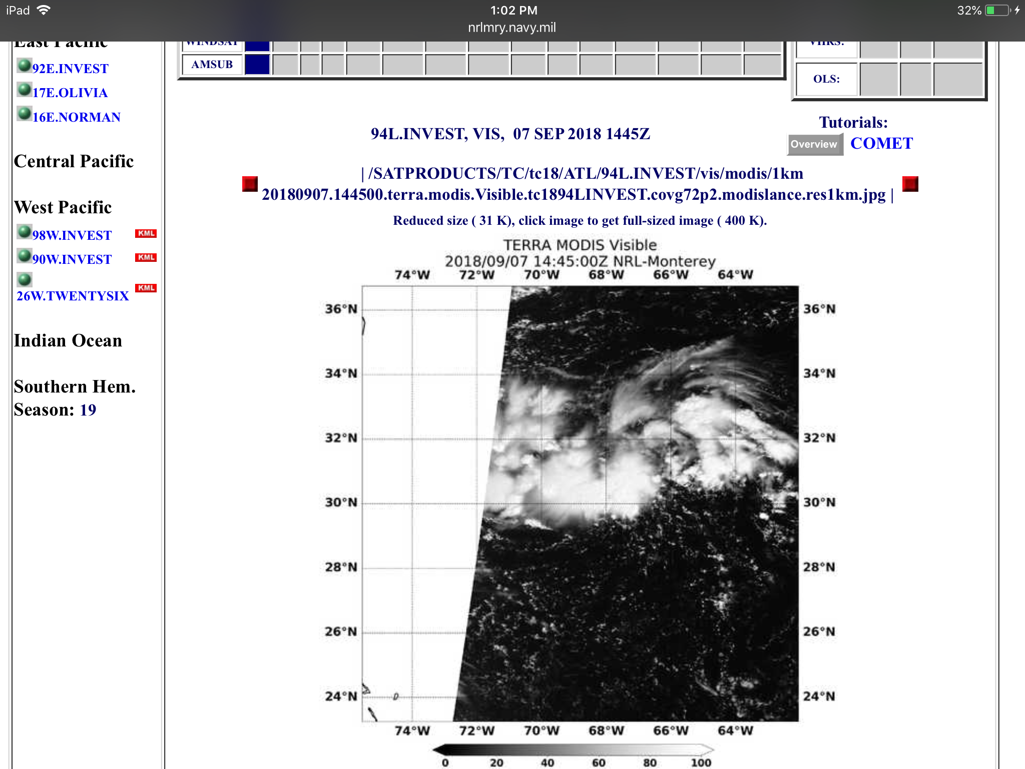
GCANE wrote:Multi-sat LL wind analysis
Wow, I’m surprised to see it so well defined there.
0 likes


Re: ATL: INVEST 94L - Discussion
3 likes
I am not a met. My interest and experiences come from the perspective of a hobby geologist, fisherwoman, and forager.
-
galaxy401
- Category 5
- Posts: 2299
- Age: 28
- Joined: Sat Aug 25, 2012 9:04 pm
- Location: Casa Grande, Arizona
Re: ATL: INVEST 94L - Discussion
Tropical Weather Outlook...Corrected
NWS National Hurricane Center Miami FL
200 PM EDT Fri Sep 7 2018
Corrected status of Florence to tropical storm in first paragraph.
For the North Atlantic...Caribbean Sea and the Gulf of Mexico:
A trough of low pressure is producing a large area of disorganized
showers and thunderstorms over the western Atlantic Ocean.
Development, if any, of this system should be slow to occur during
the next few days before environmental conditions become
unfavorable. This system is expected to move little during the
next few days.
* Formation chance through 48 hours...low...10 percent.
* Formation chance through 5 days...low...20 percent.
1 likes
Got my eyes on moving right into Hurricane Alley: Florida.
-
CrazyC83
- Professional-Met

- Posts: 33393
- Joined: Tue Mar 07, 2006 11:57 pm
- Location: Deep South, for the first time!
Re: ATL: INVEST 94L - Discussion
Could this open up a weakness for Florence to move north? Break down the ridge? It probably depends on the intensity of the two systems though.
1 likes
-
emeraldislenc
- Category 2
- Posts: 524
- Joined: Fri Aug 24, 2012 4:49 pm
- Location: Emerald Isle NC
Re: ATL: INVEST 94L - Discussion
CrazyC83 wrote:Could this open up a weakness for Florence to move north? Break down the ridge? It probably depends on the intensity of the two systems though.
that would make a lot of sense. i was wondering the same thing. i wonder if the models are picking this up as far as florence track. this could be the monkey wrench that could take it either further north or ots.
0 likes
Robbielyn McCrary
I know just about enough to sound like I know what I'm talking about sometimes. But for your safety please follow the nhc for truly professional forecasting.
I know just about enough to sound like I know what I'm talking about sometimes. But for your safety please follow the nhc for truly professional forecasting.
Who is online
Users browsing this forum: No registered users and 42 guests