ATL: Ex INVEST 96L - Discussion

Moderator: S2k Moderators

Message
Author
Aric Dunn
Category 5
Category 5
Posts: 21228
Age: 41
Joined: Sun Sep 19, 2004 9:58 pm
Location: Ready for the Chase.
Contact:

Re: ATL: INVEST 96L - Discussion

#281 Postby Aric Dunn » Mon Aug 05, 2019 2:02 pm

CyclonicFury wrote:It looks good, but there are no indications of any westerlies at the surface. A 14:30z ASCAT pass confirmed that ex-96L is still an open wave, and there are no surface observations of westerlies. There's a reason why NHC has not mentioned it on their TWO.


This has happened many times where ascat does not pick up on fast moving small systems.
1 likes   
Note: If I make a post that is brief. Please refer back to previous posts for the analysis or reasoning. I do not re-write/qoute what my initial post said each time.
If there is nothing before... then just ask :)

Space & Atmospheric Physicist, Embry-Riddle Aeronautical University,
I believe the sky is falling...

Aric Dunn
Category 5
Category 5
Posts: 21228
Age: 41
Joined: Sun Sep 19, 2004 9:58 pm
Location: Ready for the Chase.
Contact:

Re: ATL: INVEST 96L - Discussion

#282 Postby Aric Dunn » Mon Aug 05, 2019 2:12 pm

ScottNAtlanta wrote:Well, its headed straight for buoy 42059...so we shall see in fairly short order what going on here


If it does not go north of that bouy it wont really give us anything useful except pressure.

Pressure has fallen currently passed tha average background pressure so we have that at least
0 likes   
Note: If I make a post that is brief. Please refer back to previous posts for the analysis or reasoning. I do not re-write/qoute what my initial post said each time.
If there is nothing before... then just ask :)

Space & Atmospheric Physicist, Embry-Riddle Aeronautical University,
I believe the sky is falling...

User avatar
tarheelprogrammer
S2K Supporter
S2K Supporter
Posts: 1793
Joined: Mon Mar 28, 2016 9:25 pm
Location: Raleigh, NC area (Garner, NC)

Re: ATL: INVEST 96L - Discussion

#283 Postby tarheelprogrammer » Mon Aug 05, 2019 2:19 pm

This kind of looks like a TD to me. Clear rotation and looks like it is trying its best to make it to a storm, however, shear awaits it soon.
0 likes   
My posts are not official forecasts. They are just my opinion and may or may not be backed by sound meteorological data. They are NOT endorsed by any professional institution or storm2k.org. For official information, please refer to the NHC and NWS products.

floridasun78
Category 5
Category 5
Posts: 3755
Joined: Sun May 17, 2009 10:16 pm
Location: miami fl

Re: ATL: INVEST 96L - Discussion

#284 Postby floridasun78 » Mon Aug 05, 2019 2:30 pm

tarheelprogrammer wrote:This kind of looks like a TD to me. Clear rotation and looks like it is trying its best to make it to a storm, however, shear awaits it soon.

that why nhc not looking at it that much because shear ahead it
0 likes   

User avatar
AJC3
Admin
Admin
Posts: 3872
Age: 60
Joined: Tue Aug 31, 2004 7:04 pm
Location: West Melbourne, Florida
Contact:

Re: ATL: INVEST 96L - Discussion

#285 Postby AJC3 » Mon Aug 05, 2019 2:45 pm

Aric Dunn wrote:
CyclonicFury wrote:It looks good, but there are no indications of any westerlies at the surface. A 14:30z ASCAT pass confirmed that ex-96L is still an open wave, and there are no surface observations of westerlies. There's a reason why NHC has not mentioned it on their TWO.


This has happened many times where ascat does not pick up on fast moving small systems.


ASCAT doesn't show westerlies with fast-moving systems, small or large, because there usually aren't any ground-relative westerly winds with them. That looks to be the case here - the low cloud elements on the south side of the system are moving toward the N or NNW. A westward motion of 15 knots looks conservative to me....it's probably moving at close to 20 knots.


Edit: granted, I'll give you some low cloud elements on the east side of it are moving a little east of due north. Still this looks like an open wave...something like this...perhaps a wee bit more amplified about its axis, but not to the point closing off on it south side.

Image

Also - is ASCAT METOP-A having some trouble? Last imagery I see is from 30 JUL, even when you select yesterday's date.
8 likes   

User avatar
GCANE
S2K Supporter
S2K Supporter
Posts: 10787
Joined: Mon Oct 22, 2007 8:03 am

Re: ATL: INVEST 96L - Discussion

#286 Postby GCANE » Mon Aug 05, 2019 2:58 pm

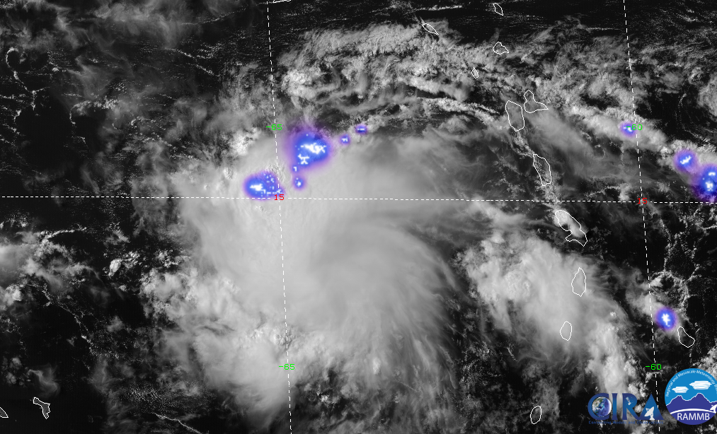
Very intense lightning now.

Image
2 likes   

floridasun78
Category 5
Category 5
Posts: 3755
Joined: Sun May 17, 2009 10:16 pm
Location: miami fl

Re: ATL: INVEST 96L - Discussion

#287 Postby floridasun78 » Mon Aug 05, 2019 3:10 pm

not sure my eye playing game but look like take more circle shape on afternoon sat pic
0 likes   

User avatar
AJC3
Admin
Admin
Posts: 3872
Age: 60
Joined: Tue Aug 31, 2004 7:04 pm
Location: West Melbourne, Florida
Contact:

Re: ATL: INVEST 96L - Discussion

#288 Postby AJC3 » Mon Aug 05, 2019 3:24 pm

floridasun78 wrote:not sure my eye playing game but look like take more circle shape on afternoon sat pic


Two things about looking at visible imagery, especially a time lapse of a fast-moving system such as this...

A. The "circular shape" you're seeing is in the mid and high level debris clouds, formed by anticyclonic flow aloft.

B. This is a really important one that I've reiterated on here over and over again. When you look at a time lapse, your eyes are following along with the wave. What this actually does is to create a visual storm relative rotation that is either exaggerated or non-existent at the surface. To get a better ground-relative sense of low cloud motion, you need to: (1) Zoom well in on the system, (2) Fix your eyes on a single point and focus on the motion of cloud elements relative to that point, and finally (3) Focus only on the low cloud elements - not any debris clouds. Look at the motion of the open-cell cumulus (the smaller white 'dots' on the imagery) as well as thunderstorm outflow boundaries. Both of these features exist at around 1-1.5KM (3-5KFT) or so.

Fast moving systems are no doubt tricky to diagnose whether or not they are closed at the surface or low cloud level. While scatterometer (ASCAT) data does have its limitations, in absence of surface observational data over open ocean areas, it gives you a much better indication of what surface/low level streamlines look like than does human visual estimation.
10 likes   

Aric Dunn
Category 5
Category 5
Posts: 21228
Age: 41
Joined: Sun Sep 19, 2004 9:58 pm
Location: Ready for the Chase.
Contact:

Re: ATL: INVEST 96L - Discussion

#289 Postby Aric Dunn » Mon Aug 05, 2019 3:28 pm

AJC3 wrote:
floridasun78 wrote:not sure my eye playing game but look like take more circle shape on afternoon sat pic


Two things about looking at visible imagery, especially a time lapse of a fast-moving system such as this...

A. The "circular shape" you're seeing is in the mid and high level debris clouds, formed by anticyclonic flow aloft.

B. This is a really important one that I've reiterated on here over and over again. When you look at a time lapse, your eyes are following along with the wave. What this actually does is to create a visual storm relative rotation that is either exaggerated or non-existent at the surface. To get a better ground-relative sense of low cloud motion, you need to: (1) Zoom well in on the system, (2) Fix your eyes on a single point and focus on the motion of cloud elements relative to that point, and finally (3) Focus only on the low cloud elements - not any debris clouds. Look at the motion of the open-cell cumulus (the smaller white 'dots' on the imagery) as well as thunderstorm outflow boundaries. Both of these features exist at around 1-1.5KM (3-5KFT) or so.

Fast moving systems are no doubt tricky to diagnose whether or not they are closed at the surface or low cloud level. While scatterometer (ASCAT) data does have its limitations, in absence of surface observational data over open ocean areas, it gives you a much better indication of what surface/low level streamlines look like than does human visual estimation.


Yeppers.. learned that from you like 15 years ago or something lol
3 likes   
Note: If I make a post that is brief. Please refer back to previous posts for the analysis or reasoning. I do not re-write/qoute what my initial post said each time.
If there is nothing before... then just ask :)

Space & Atmospheric Physicist, Embry-Riddle Aeronautical University,
I believe the sky is falling...

Aric Dunn
Category 5
Category 5
Posts: 21228
Age: 41
Joined: Sun Sep 19, 2004 9:58 pm
Location: Ready for the Chase.
Contact:

Re: ATL: INVEST 96L - Discussion

#290 Postby Aric Dunn » Mon Aug 05, 2019 4:24 pm

Funny thing .. if this had formed earlier the models would have been pretty far off. the ridging was quite a bit stronger and built/moved farther west.
0 likes   
Note: If I make a post that is brief. Please refer back to previous posts for the analysis or reasoning. I do not re-write/qoute what my initial post said each time.
If there is nothing before... then just ask :)

Space & Atmospheric Physicist, Embry-Riddle Aeronautical University,
I believe the sky is falling...

Frank P
S2K Supporter
S2K Supporter
Posts: 2408
Joined: Fri Aug 29, 2003 10:52 am
Location: Biloxi Beach, Ms

Re: ATL: INVEST 96L - Discussion

#291 Postby Frank P » Mon Aug 05, 2019 5:30 pm

Satellite loops on this system are interesting to watch... best its ever looked IMO... probably go poof right after I post this... still hauling butt but does have a nice overall tropical cloud presentation... wonder if the NHC will resurrect it tomorrow if it maintains this consistency, currently not getting any respect from anyone yet... make note, in the unlikely event it holds up what it has and reaches the GOM then I recon things could be a little more interesting.. its all we have to track at the moment..
3 likes   

User avatar
TheStormExpert
Category 5
Category 5
Posts: 8487
Age: 30
Joined: Wed Feb 16, 2011 5:38 pm
Location: Palm Beach Gardens, FL

Re: ATL: INVEST 96L - Discussion

#292 Postby TheStormExpert » Mon Aug 05, 2019 7:20 pm

How is this at least not getting a mention by the NHC!? :lol:

This is the best 96L has EVER looked!
2 likes   
The following post is NOT an official forecast and should not be used as such. It is just the opinion of the poster and may or may not be backed by sound meteorological data. It is NOT endorsed by storm2k.org.

Aric Dunn
Category 5
Category 5
Posts: 21228
Age: 41
Joined: Sun Sep 19, 2004 9:58 pm
Location: Ready for the Chase.
Contact:

Re: ATL: INVEST 96L - Discussion

#293 Postby Aric Dunn » Mon Aug 05, 2019 7:29 pm

Well it tried really hard..
1 likes   
Note: If I make a post that is brief. Please refer back to previous posts for the analysis or reasoning. I do not re-write/qoute what my initial post said each time.
If there is nothing before... then just ask :)

Space & Atmospheric Physicist, Embry-Riddle Aeronautical University,
I believe the sky is falling...

User avatar
GCANE
S2K Supporter
S2K Supporter
Posts: 10787
Joined: Mon Oct 22, 2007 8:03 am

Re: ATL: INVEST 96L - Discussion

#294 Postby GCANE » Mon Aug 05, 2019 7:35 pm

Aric Dunn wrote:Well it tried really hard..


It went all day long sparked by that big tower this morning.

Still has a lot to work with.

I am waiting to see what happens in the morning.
0 likes   

floridasun78
Category 5
Category 5
Posts: 3755
Joined: Sun May 17, 2009 10:16 pm
Location: miami fl

Re: ATL: INVEST 96L - Discussion

#295 Postby floridasun78 » Mon Aug 05, 2019 8:03 pm

if not thing by now i think time to look next invest few week thing not going it way
0 likes   

Aric Dunn
Category 5
Category 5
Posts: 21228
Age: 41
Joined: Sun Sep 19, 2004 9:58 pm
Location: Ready for the Chase.
Contact:

Re: ATL: INVEST 96L - Discussion

#296 Postby Aric Dunn » Mon Aug 05, 2019 8:14 pm

GCANE wrote:
Aric Dunn wrote:Well it tried really hard..


It went all day long sparked by that big tower this morning.

Still has a lot to work with.

I am waiting to see what happens in the morning.

I wont write it off I know better.. but if the convection collapsed almost certainly is open

The other thing is the low level circ and mid level are clearly not stacked at the moment. though the mid level has still about 24 hours till it runs into the shear. the northern low level circ has about 12 hours.
0 likes   
Note: If I make a post that is brief. Please refer back to previous posts for the analysis or reasoning. I do not re-write/qoute what my initial post said each time.
If there is nothing before... then just ask :)

Space & Atmospheric Physicist, Embry-Riddle Aeronautical University,
I believe the sky is falling...

User avatar
wxman57
Moderator-Pro Met
Moderator-Pro Met
Posts: 22482
Age: 66
Joined: Sat Jun 21, 2003 8:06 pm
Location: Houston, TX (southwest)

Re: ATL: INVEST 96L - Discussion

#297 Postby wxman57 » Mon Aug 05, 2019 8:54 pm

ASCAT hit today says trof axis at the surface. There is no LLC.
3 likes   

User avatar
Hurricane Jed
Category 2
Category 2
Posts: 542
Age: 36
Joined: Mon Jan 24, 2011 3:36 pm
Location: Cen Tex

Re: ATL: INVEST 96L - Discussion

#298 Postby Hurricane Jed » Mon Aug 05, 2019 8:56 pm

There is too much going against it
1 likes   

User avatar
SouthFloridawx
S2K Supporter
S2K Supporter
Posts: 8344
Age: 45
Joined: Tue Jul 26, 2005 1:16 am
Location: Sarasota, FL
Contact:

Re: ATL: INVEST 96L - Discussion

#299 Postby SouthFloridawx » Mon Aug 05, 2019 9:26 pm

I wasn't expecting anything, so it's nice to just have something to watch.

Sent from my SM-G930P using Tapatalk
0 likes   

Monsoonjr99
Tropical Storm
Tropical Storm
Posts: 208
Age: 24
Joined: Fri Sep 21, 2018 11:22 pm
Location: Inland Empire, SoCal

Re: ATL: INVEST 96L - Discussion

#300 Postby Monsoonjr99 » Tue Aug 06, 2019 12:02 am

Seems like convection has waned. Nice mid-level swirl, but this is moving too fast and will soon hit shear. The NHC removed this from the TWO for a reason. Conditions currently are just unfavorable for development. Time to wait for the next disturbance...
2 likes   
The posts in this forum are NOT official forecasts and should not be used as such. They are just the opinion of the poster and may or may not be backed by sound meteorological data. They are NOT endorsed by any professional institution or STORM2K. For official information, please refer to products from the NHC and NWS.

Some Californian who codes things and tracks weather.

Kay '22, Hilary '23


Return to “2019”

Who is online

Users browsing this forum: No registered users and 64 guests