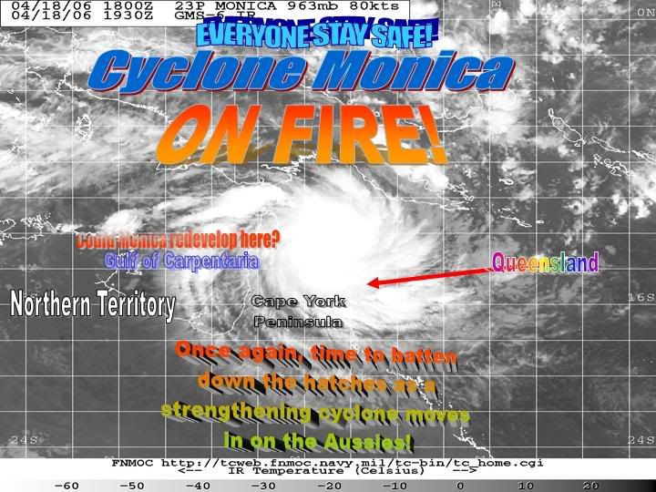
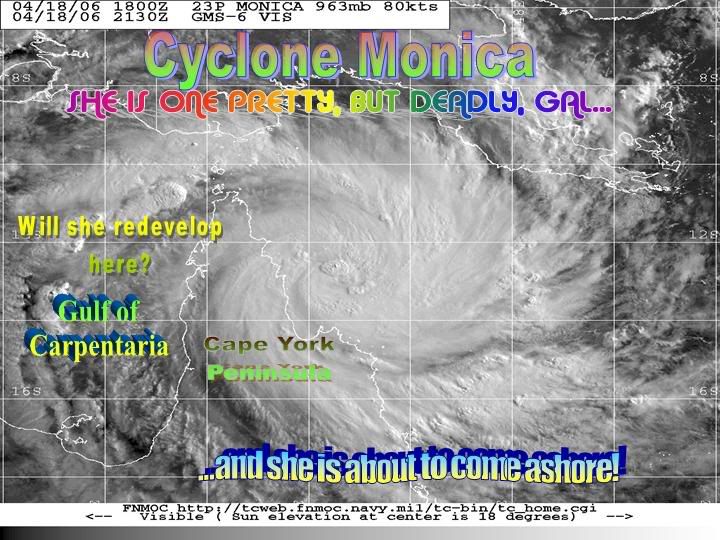
80kts, 965hPa
HIGH SEAS WEATHER WARNING FOR METAREA 10 ISSUED BY THE AUSTRALIAN BUREAU OF
METEOROLOGY, BRISBANE 1814 UTC 18 April 2006
HURRICANE WARNING FOR NORTH EASTERN AREA
SITUATION
Severe Tropical Cyclone Monica with a central pressure of 965 hectopascals
centred at 1800 UTC near 12.9 south 144.8 east moving west at 8 knots. Position
fair.
AREA AFFECTED
Within 120 nm of the centre.
FORECAST
Clockwise winds greater than 34 knots within 120 nm of the centre.
Maximum winds to 80 knots near the centre.
High to very high seas on heavy swells.
Forecast positions
At 190600 UTC overland near 13.0 S 142.9 E with central pressure 970 hPa and
maximum winds near the centre to 65 knots.
At 191800 UTC in the Gulf of Carpentaria near 13.2 S 141.2 E with central
pressure 980 hPa and maximum winds near the centre to 55 knots.
Monica is expected to move west over the Gulf of Carpentaria and reintensify
during the following 24 hours.
REMARKS
All ships in the area please send weather reports every three hours. Regular
weather observing ships use normal channels. Other ships please use either
email to marwxqld@bom.gov.au or fax to +61732200221 or satellite to SAC 41
through Land Earth Station Perth 222.
WEATHER BRISBANE
Cyclone Monica - Cat. 5
Moderator: S2k Moderators
-
hurricanefloyd5

- Category 5

- Posts: 1659
- Age: 43
- Joined: Sun May 02, 2004 10:53 am
- Location: Spartanburg
- Contact:
P.K. wrote:80kts, 965hPa
HIGH SEAS WEATHER WARNING FOR METAREA 10 ISSUED BY THE AUSTRALIAN BUREAU OF
METEOROLOGY, BRISBANE 1814 UTC 18 April 2006
HURRICANE WARNING FOR NORTH EASTERN AREA
SITUATION
Severe Tropical Cyclone Monica with a central pressure of 965 hectopascals
centred at 1800 UTC near 12.9 south 144.8 east moving west at 8 knots. Position
fair.
AREA AFFECTED
Within 120 nm of the centre.
FORECAST
Clockwise winds greater than 34 knots within 120 nm of the centre.
Maximum winds to 80 knots near the centre.
High to very high seas on heavy swells.
Forecast positions
At 190600 UTC overland near 13.0 S 142.9 E with central pressure 970 hPa and
maximum winds near the centre to 65 knots.
At 191800 UTC in the Gulf of Carpentaria near 13.2 S 141.2 E with central
pressure 980 hPa and maximum winds near the centre to 55 knots.
Monica is expected to move west over the Gulf of Carpentaria and reintensify
during the following 24 hours.
REMARKS
All ships in the area please send weather reports every three hours. Regular
weather observing ships use normal channels. Other ships please use either
email to marwxqld@bom.gov.au or fax to +61732200221 or satellite to SAC 41
through Land Earth Station Perth 222.
WEATHER BRISBANE
this is faults proof unless someone a prove that it is a Severe Tropical Cyclone!!!!!!!!!!!!
where is the proof!!!!!!!!!!!!!!!!!!!!!!!!!!!!!! winds of 80mph winds and thats a Severe Tropical Cyclone????????????????????????
0 likes
-
SouthFloridawx

- S2K Supporter

- Posts: 8344
- Age: 45
- Joined: Tue Jul 26, 2005 1:16 am
- Location: Sarasota, FL
- Contact:
-
DoctorHurricane2003
-
MiamiensisWx
http://152.80.49.216/tc-bin/tc_home.cgi
IMPRESSIVE CONVECTION, SHAPE, AND OUTFLOW! VERY WELL-ORGANIZED AND ABOUT TO STRIKE!
IMPRESSIVE CONVECTION, SHAPE, AND OUTFLOW! VERY WELL-ORGANIZED AND ABOUT TO STRIKE!
Last edited by MiamiensisWx on Tue Apr 18, 2006 3:35 pm, edited 1 time in total.
0 likes
-
cycloneye

- Admin

- Posts: 139027
- Age: 67
- Joined: Thu Oct 10, 2002 10:54 am
- Location: San Juan, Puerto Rico
IDQP0005
Australian Government Bureau of Meteorology
Queensland
Tropical Cyclone Warning Centre
Media: For immediate broadcast. Transmitters over Cape York Peninsula north of
Pormpuraaw are requested to use the Standard Emergency Warning Signal.
TOP PRIORITY
CORRECTED - TROPICAL CYCLONE ADVICE NUMBER 13
Issued by the Bureau of Meteorology, Brisbane
Issued at 6:01am on Wednesday the 19th of April 2006
A CYCLONE WARNING is current for coastal and island communities between Torres
Strait and Cape Melville, extending across Cape York Peninsula to all areas
north of Pormpuraaw.
A CYCLONE WATCH has also been issued for Northern Territory coastal and island
communities between Groote Eylandt and Elcho Island including Nhulunbuy.
At 5am EST, Severe Tropical Cyclone Monica, Category 3, was centred using an
accurate satellite fix near latitude 12.5 south longitude 144.8 east, 150
kilometres east northeast of Lockhart River. The cyclone is moving west at about
15 km/h.
Tropical Cyclone Monica is expected to intensify further this morning and
continue moving on a general westward track. DESTRUCTIVE WINDS with gusts above
130 km/h should extend onto the coast between Cape Grenville and Coen this
morning. STRONG GALES are expected to develop other areas between Torres Strait
and Cape Melville.
The VERY DESTRUCTIVE core of Monica with wind gusts up to 220 km/hr is expected
to cross the coast in the general area of Lockhart River around midday.
Tropical Cyclone Monica is expected to continue moving westwards across Cape
York Peninsula later today and into the Gulf of Carpentaria early on Thursday.
Gales may develop about the Northern Territory coast between Groote Eylandt and
Elcho Island, including Nhulunbuy, late Thursday night.
Details of Severe Tropical Cyclone Monica, Category 3, for 5am EST Wednesday.
Central Pressure : 965 Hectopascals
Location of Centre : within 60 kilometres of
latitude 12.5 degrees south
longitude 144.8 degrees east
150 km east northeast of Lockhart River.
Recent Movement : West at 15 kilometres per hour
Destructive winds : out to 75 kilometres from the centre
Maximum wind gusts : 200 kilometres per hour, and INTENSIFYING.
Coastal residents between Cape Grenville and Cape Melville are specifically
warned of the dangerous storm tide as the cyclone crosses the coast. The sea is
likely to rise steadily up to a level significantly above the normal tide, with
damaging waves and flooding of some low-lying areas extending some way inland.
People living in areas likely to be affected by this flooding should take
measures to protect their property as much as possible and be prepared to follow
directions regarding evacuation of the area if advised to do so by the
authorities.
Very heavy flooding rain will develop over land later this morning.
People in communities in Torres Strait and over Cape York Peninsula north of a
line from Pormpuraaw to Cape Melville should complete preparations quickly and
be prepared to shelter in a safe place.
The next warning will be issued at 8am EST Wednesday.
Wow this is now a very intense cyclone.
0 likes
Visit the Caribbean-Central America Weather Thread where you can find at first post web cams,radars
and observations from Caribbean basin members Click Here
and observations from Caribbean basin members Click Here
-
MiamiensisWx
-
Matt-hurricanewatcher

- Category 5
- Posts: 11649
- Age: 38
- Joined: Fri Nov 26, 2004 11:09 pm
- Location: Portland,OR
- Contact:
-
SouthFloridawx
- S2K Supporter
- Posts: 8344
- Age: 45
- Joined: Tue Jul 26, 2005 1:16 am
- Location: Sarasota, FL
- Contact:
-
hurricanefloyd5
- Category 5
- Posts: 1659
- Age: 43
- Joined: Sun May 02, 2004 10:53 am
- Location: Spartanburg
- Contact:
-
hurricanefloyd5
- Category 5
- Posts: 1659
- Age: 43
- Joined: Sun May 02, 2004 10:53 am
- Location: Spartanburg
- Contact:
-
DoctorHurricane2003
-
P.K.

- Professional-Met

- Posts: 5149
- Joined: Thu Sep 23, 2004 5:57 pm
- Location: Watford, England
- Contact:
They list the categories in the public advisories and on the track maps. http://www.bom.gov.au/products/IDQ65240.shtml
0 likes
-
hurricanefloyd5
- Category 5
- Posts: 1659
- Age: 43
- Joined: Sun May 02, 2004 10:53 am
- Location: Spartanburg
- Contact:
P.K. wrote:They list the categories in the public advisories and on the track maps. http://www.bom.gov.au/products/IDQ65240.shtml
tyvm P.K. and i am truly sorry to everyone here!!!!!!!!!!!!!!!!!!!!!!!!!!!
0 likes
-
senorpepr

- Military Met/Moderator

- Posts: 12542
- Age: 41
- Joined: Fri Aug 22, 2003 9:22 pm
- Location: Mackenbach, Germany
- Contact:
IDQP0005
Australian Government Bureau of Meteorology
Queensland
Tropical Cyclone Warning Centre
Media: For immediate broadcast. Transmitters over Cape York Peninsula north of
Pormpuraaw are requested to use the Standard Emergency Warning Signal.
TOP PRIORITY
TROPICAL CYCLONE ADVICE NUMBER 14
Issued by the Bureau of Meteorology, Brisbane
Issued at 7:37am on Wednesday the 19th of April 2006
A CYCLONE WARNING is current for coastal and island communities between Torres
Strait and Cape Melville, extending across Cape York Peninsula to all areas
north of Pormpuraaw.
A CYCLONE WATCH has also been issued for Northern Territory coastal and island
communities between Groote Eylandt and Elcho Island including Nhulunbuy.
At 7am EST, Severe Tropical Cyclone Monica, Category 3, was centred near
latitude 12.6 south longitude 144.6 east, 125 kilometres east northeast of
Lockhart River. The cyclone is moving in a general westward direction at about
12 km/h.
Tropical Cyclone Monica is expected to intensify further this morning and
continue moving on a general westward track. DESTRUCTIVE WINDS with gusts above
130 km/h should extend onto the coast between Cape Grenville and Coen this
morning. STRONG GALES are expected to develop other areas between Torres Strait
and Cape Melville.
The VERY DESTRUCTIVE core of Monica with wind gusts increasing up to 220 km/hr
is expected to cross the coast in the general area of Lockhart River around
midday.
Tropical Cyclone Monica is expected to continue moving westwards across Cape
York Peninsula later today and into the Gulf of Carpentaria early on Thursday.
Gales may develop about the Northern Territory coast between Groote Eylandt and
Elcho Island, including Nhulunbuy, late Thursday night.
Details of Severe Tropical Cyclone Monica, Category 3, for 7am EST Wednesday.
Central Pressure : 960 Hectopascals
Location of Centre : within 40 kilometres of
latitude 12.6 degrees south
longitude 144.6 degrees east
125 km east northeast of Lockhart River.
Recent Movement : West at 12 kilometres per hour
Destructive winds : out to 75 kilometres from the centre
Maximum wind gusts : 200 kilometres per hour, and INTENSIFYING.
Coastal residents between Cape Grenville and Cape Melville are specifically
warned of the dangerous storm tide as the cyclone crosses the coast. The sea is
likely to rise steadily up to a level significantly above the normal tide, with
damaging waves and flooding of some low-lying areas extending some way inland.
People living in areas likely to be affected by this flooding should take
measures to protect their property as much as possible and be prepared to follow
directions regarding evacuation of the area if advised to do so by the
authorities.
Very heavy flooding rain will develop over land later this morning.
People in communities in Torres Strait and over Cape York Peninsula north of a
line from Pormpuraaw to Cape Melville should complete preparations quickly and
be prepared to shelter in a safe place.
The next warning will be issued by 9am EST Wednesday and hourly from then on.
This warning is also available through TV and Radio Broadcasts; the Bureau's
website at http://www.bom.gov.au or call 1300 659 212. The Bureau and the State
Emergency Service would appreciate this warning being broadcast regularly.
0 likes
-
MiamiensisWx
-
Matt-hurricanewatcher
- Category 5
- Posts: 11649
- Age: 38
- Joined: Fri Nov 26, 2004 11:09 pm
- Location: Portland,OR
- Contact:
Who is online
Users browsing this forum: No registered users and 27 guests