Tropical Storm Ophelia

Moderator: S2k Moderators

Message
Author
User avatar
cycloneye
Admin
Admin
Posts: 139198
Age: 67
Joined: Thu Oct 10, 2002 10:54 am
Location: San Juan, Puerto Rico

#21 Postby cycloneye » Tue Sep 06, 2005 8:31 am

Image

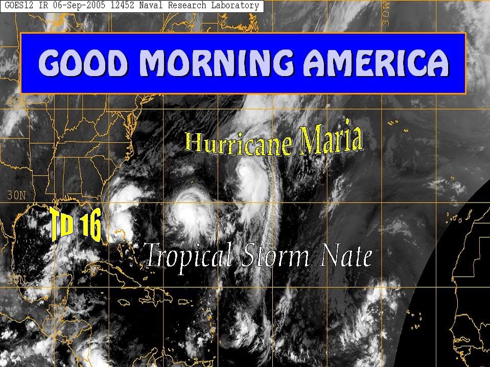
Tropical Cyclone Formation Alert.That is the projected path they have for now TD16.
0 likes   
Visit the Caribbean-Central America Weather Thread where you can find at first post web cams,radars
and observations from Caribbean basin members Click Here

Frank2
Category 5
Category 5
Posts: 4061
Joined: Mon Jul 25, 2005 12:47 pm

#22 Postby Frank2 » Tue Sep 06, 2005 8:33 am

I'm greatful for that mid-Atlantic trough some of us were commenting about during the lull of mid-July through mid-August (at least a dozen strong waves or named systems (combined total) have been forced northward by this feature) - can you imagine what would have happened had it not been there!!

Frank
0 likes   

User avatar
Ivanhater
Storm2k Moderator
Storm2k Moderator
Posts: 10852
Age: 37
Joined: Fri Jul 01, 2005 8:25 am
Location: Pensacola

#23 Postby Ivanhater » Tue Sep 06, 2005 8:35 am

Frank2 wrote:I'm greatful for that mid-Atlantic trough some of us were commenting about during the lull of mid-July through mid-August (at least a dozen strong waves or named systems (combined total) have been forced northward by this feature) - can you imagine what would have happened had it not been there!!

Frank


well, it also kept some from developing that far out, so they continued westward
0 likes   

Frank2
Category 5
Category 5
Posts: 4061
Joined: Mon Jul 25, 2005 12:47 pm

#24 Postby Frank2 » Tue Sep 06, 2005 8:39 am

True, but, there would have been at least several major hurricanes entering the Caribbean (or Gulf) had it not been for this trough - still better that it has been there, instead of having not been there at all.

Frank
0 likes   

jlauderdal
S2K Supporter
S2K Supporter
Posts: 6776
Joined: Wed May 19, 2004 5:46 am
Location: NE Fort Lauderdale
Contact:

#25 Postby jlauderdal » Tue Sep 06, 2005 8:41 am

Frank2 wrote:Winds are very light to calm here in Fort Lauderdale at this hour, with overcast skies and light rain since sunrise.

Hard to say where the NHC will put the circulation center, though the radar image does seem to suggest that it's just off our coast, and drifting southeastward at this time.

Click on http://www.srh.noaa.gov/radar/loop/DS.p ... kamx.shtml to view.

So much for my lunch date with the NHC this week...

Frank


I concur with your radar analysis although looks SW to me but its probably just a function of a center organizing and not really a true SW motion.
0 likes   

User avatar
cycloneye
Admin
Admin
Posts: 139198
Age: 67
Joined: Thu Oct 10, 2002 10:54 am
Location: San Juan, Puerto Rico

#26 Postby cycloneye » Tue Sep 06, 2005 8:44 am

Ok folks let's not have so many replies at this advisorie thread to have it only for that purpose.You can replie at the TD16 thread.Locked until half an hour before 11 AM.
0 likes   
Visit the Caribbean-Central America Weather Thread where you can find at first post web cams,radars
and observations from Caribbean basin members Click Here

User avatar
HURAKAN
Professional-Met
Professional-Met
Posts: 46086
Age: 37
Joined: Thu May 20, 2004 4:34 pm
Location: Key West, FL
Contact:

#27 Postby HURAKAN » Tue Sep 06, 2005 8:46 am

Image
0 likes   

Frank2
Category 5
Category 5
Posts: 4061
Joined: Mon Jul 25, 2005 12:47 pm

#28 Postby Frank2 » Tue Sep 06, 2005 8:46 am

Re: jlauderdal's post

I just noticed that what appears to be a circulation center just off our coastline is appearantly a secondary circulation center - if you look at the very eastern edge of the radar return, you can see what appears to be the western edge of the center the NHC is using (south of Grand Bahama Island), and this center appears to be drifting slowly eastward at this time.

Apparently the southeastward movement of this secondary circulation center is due to it's cyclonic movement around the main circulation center.

When I worked at the NHC, I can recall reading a journal article on this very topic, with the authors noting that multiple circulation centers are common in weak systems (I can't recall who the authors were, unfortunately).

Click on http://www.srh.noaa.gov/radar/loop/DS.p ... kamx.shtml to view.

Frank
0 likes   

User avatar
artist
Category 5
Category 5
Posts: 9793
Joined: Mon Jun 06, 2005 3:26 pm
Location: West Palm

#29 Postby artist » Tue Sep 06, 2005 8:56 am

which of the models looks most reasonable? is the gfdl really a player?
0 likes   

User avatar
Jevo
S2K Supporter
S2K Supporter
Posts: 1729
Age: 46
Joined: Tue Aug 03, 2004 8:45 pm
Location: The Flemish Cap
Contact:

#30 Postby Jevo » Tue Sep 06, 2005 8:58 am

NOOOOOOOO I close on my house this Friday!!!!!!!

Palm Beach County

:grr: :grr: :grr: :grr: :grr:
0 likes   
Disclaimer: 50% of the time I have no clue of what I am talking about. Chances are I am taking a less than educated guess that sounds good because 10 years ago I stole Mike Watkins book 'The Hurricane and its Impact'. For official information please direct yourself to the NHC and their cadre of weather geniuses.

jlauderdal
S2K Supporter
S2K Supporter
Posts: 6776
Joined: Wed May 19, 2004 5:46 am
Location: NE Fort Lauderdale
Contact:

#31 Postby jlauderdal » Tue Sep 06, 2005 9:01 am

Frank2 wrote:Re: jlauderdal's post

I just noticed that what appears to be a circulation center just off our coastline is appearantly a secondary circulation center - if you look at the very eastern edge of the radar return, you can see what appears to be the western edge of the center the NHC is using (south of Grand Bahama Island), and this center appears to be drifting slowly eastward at this time.

Apparently the southeastward movement of this secondary circulation center is due to it's cyclonic movement around the main circulation center.

When I worked at the NHC, I can recall reading a journal article on this very topic, with the authors noting that multiple circulation centers are common in weak systems (I can't recall who the authors were, unfortunately).

Click on http://www.srh.noaa.gov/radar/loop/DS.p ... kamx.shtml to view.

Frank


yes, katrina when it was developing in the SE bahmas had multiple vortices
0 likes   

User avatar
feederband
S2K Supporter
S2K Supporter
Posts: 3423
Joined: Wed Oct 01, 2003 6:21 pm
Location: Lakeland Fl

#32 Postby feederband » Tue Sep 06, 2005 9:25 am

Td 16 appears to be winding up very well right now..

http://www.ssd.noaa.gov/PS/TROP/DATA/RT ... -loop.html
0 likes   

rockyman
Category 5
Category 5
Posts: 1967
Joined: Thu Jun 26, 2003 12:24 pm
Location: Dauphin Island, AL

#33 Postby rockyman » Tue Sep 06, 2005 9:27 am

Here's the steering currents for TD15 at current strength:
Image

I do see an "escape route" if the system gets stronger:
Image
0 likes   

Terry
S2K Supporter
S2K Supporter
Posts: 1450
Joined: Wed Aug 11, 2004 8:25 pm
Location: Lakeland and Anna Maria Island, FL
Contact:

#34 Postby Terry » Tue Sep 06, 2005 9:33 am

Jevo wrote:
NOOOOOOOO I close on my house this Friday!!!!!!!

Palm Beach County

:grr: :grr: :grr: :grr: :grr:


I don't think that will happen now. Sorry.
0 likes   

Brent
S2K Supporter
S2K Supporter
Posts: 37123
Age: 35
Joined: Sun May 16, 2004 10:30 pm
Location: Tulsa Oklahoma
Contact:

#35 Postby Brent » Tue Sep 06, 2005 9:36 am

TROPICAL DEPRESSION SIXTEEN FORECAST/ADVISORY NUMBER 1
NWS TPC/NATIONAL HURRICANE CENTER MIAMI FL AL162005
1500Z TUE SEP 06 2005

AT 11 AM EDT...1500Z...A TROPICAL STORM WARNING HAS BEEN ISSUED FOR
THE EAST COAST OF FLORIDA FROM NORTH OF JUPITER NORTHWARD TO
TITUSVILLE INCLUDING MERRITT ISLAND...AND THE GOVERNMENT OF THE
BAHAMAS HAS ISSUED A TROPICAL STORM WARNING FOR GRAND BAHAMA AND
THE ABACOS.

A TROPICAL STORM WARNING MEANS THAT TROPICAL STORM CONDITIONS ARE
EXPECTED WITHIN THE WARNING AREA WITHIN THE NEXT 24 HOURS.

TROPICAL DEPRESSION CENTER LOCATED NEAR 26.5N 78.6W AT 06/1500Z
POSITION ACCURATE WITHIN 30 NM

PRESENT MOVEMENT IS STATIONARY

ESTIMATED MINIMUM CENTRAL PRESSURE 1007 MB
MAX SUSTAINED WINDS 25 KT WITH GUSTS TO 35 KT.
WINDS AND SEAS VARY GREATLY IN EACH QUADRANT. RADII IN NAUTICAL
MILES ARE THE LARGEST RADII EXPECTED ANYWHERE IN THAT QUADRANT.

REPEAT...CENTER LOCATED NEAR 26.5N 78.6W AT 06/1500Z
AT 06/1200Z CENTER WAS LOCATED NEAR 26.5N 78.5W

FORECAST VALID 07/0000Z 27.0N 79.0W
MAX WIND 35 KT...GUSTS 45 KT.
34 KT... 30NE 30SE 0SW 30NW.

FORECAST VALID 07/1200Z 27.6N 79.3W
MAX WIND 40 KT...GUSTS 50 KT.
34 KT... 50NE 50SE 25SW 50NW.

FORECAST VALID 08/0000Z 28.0N 79.7W
MAX WIND 50 KT...GUSTS 60 KT.
50 KT... 25NE 25SE 0SW 25NW.
34 KT... 50NE 50SE 25SW 50NW.

FORECAST VALID 08/1200Z 28.5N 80.0W
MAX WIND 60 KT...GUSTS 75 KT.
50 KT... 25NE 25SE 0SW 25NW.
34 KT... 50NE 50SE 25SW 50NW.

FORECAST VALID 09/1200Z 29.0N 80.5W
MAX WIND 60 KT...GUSTS 75 KT.
50 KT... 25NE 25SE 0SW 25NW.
34 KT... 50NE 50SE 25SW 50NW.

EXTENDED OUTLOOK. NOTE...ERRORS FOR TRACK HAVE AVERAGED NEAR 250 NM
ON DAY 4 AND 325 NM ON DAY 5...AND FOR INTENSITY NEAR 20 KT EACH DAY

OUTLOOK VALID 10/1200Z 29.5N 81.0W
MAX WIND 60 KT...GUSTS 75 KT.

OUTLOOK VALID 11/1200Z 30.5N 82.0W...INLAND
MAX WIND 40 KT...GUSTS 50 KT.

REQUEST FOR 3 HOURLY SHIP REPORTS WITHIN 300 MILES OF 26.5N 78.6W

NEXT ADVISORY AT 06/2100Z

FORECASTER AVILA
0 likes   
#neversummer

Brent
S2K Supporter
S2K Supporter
Posts: 37123
Age: 35
Joined: Sun May 16, 2004 10:30 pm
Location: Tulsa Oklahoma
Contact:

#36 Postby Brent » Tue Sep 06, 2005 9:37 am

Image
0 likes   
#neversummer

User avatar
melhow
S2K Supporter
S2K Supporter
Posts: 362
Joined: Sat Sep 04, 2004 4:00 pm
Location: Safety Harbor, FL

#37 Postby melhow » Tue Sep 06, 2005 9:37 am

Terry wrote:Jevo wrote:
NOOOOOOOO I close on my house this Friday!!!!!!!

Palm Beach County

:grr: :grr: :grr: :grr: :grr:


I don't think that will happen now. Sorry.


Why not? People close on houses in the rain all of the time...
0 likes   

Brent
S2K Supporter
S2K Supporter
Posts: 37123
Age: 35
Joined: Sun May 16, 2004 10:30 pm
Location: Tulsa Oklahoma
Contact:

#38 Postby Brent » Tue Sep 06, 2005 9:44 am

BULLETIN
TROPICAL DEPRESSION SIXTEEN ADVISORY NUMBER 1
NWS TPC/NATIONAL HURRICANE CENTER MIAMI FL
11 AM EDT TUE SEP 06 2005

...NEW TROPICAL DEPRESSION FORMS IN THE NORTHWESTERN BAHAMAS...
EXPECTED TO BECOME A TROPICAL STORM...

AT 11 AM EDT...1500Z...A TROPICAL STORM WARNING HAS BEEN ISSUED FOR
THE EAST COAST OF FLORIDA FROM NORTH OF JUPITER NORTHWARD TO
TITUSVILLE INCLUDING MERRITT ISLAND...AND THE GOVERNMENT OF THE
BAHAMAS HAS ISSUED A TROPICAL STORM WARNING FOR GRAND BAHAMA
THE ABACOS...AND BIMINI.

A TROPICAL STORM WARNING MEANS THAT TROPICAL STORM CONDITIONS ARE
EXPECTED WITHIN THE WARNING AREA WITHIN THE NEXT 24 HOURS.

FOR STORM INFORMATION SPECIFIC TO YOUR AREA...INCLUDING POSSIBLE
INLAND WATCHES AND WARNINGS...PLEASE MONITOR PRODUCTS ISSUED
BY YOUR LOCAL WEATHER OFFICE.

AT 11 AM EDT...1500Z...THE CENTER OF TROPICAL DEPRESSION SIXTEEN WAS
LOCATED NEAR LATITUDE 26.5 NORTH...LONGITUDE 78.6 WEST OR ABOUT
10 MILES... 20 KM...EAST OF FREEPORT GRAND BAHAMA ISLAND AND ABOUT
180 MILES... 290 KM...SOUTHEAST OF CAPE CANAVERAL FLORIDA.

THE DEPRESSION IS STATIONARY BUT A SLOW NORTH-NORTHWEST TRACK SHOULD
BEGIN LATER TODAY.

MAXIMUM SUSTAINED WINDS ARE NEAR 30 MPH... 45 KM/HR...WITH HIGHER
GUSTS. THE DEPRESSION COULD BECOME A TROPICAL STORM TONIGHT OR
WEDNESDAY. A RECONNAISSANCE PLANE IS SCHEDULED TO INVESTIGATE THE
DEPRESSION LATER TODAY.

ESTIMATED MINIMUM CENTRAL PRESSURE IS 1007 MB...29.74 INCHES.

RAINFALL ACCUMULATIONS OF 5 TO 10 INCHES...WITH ISOLATED HIGHER
AMOUNTS OF 15 INCHES CAN BE EXPECTED IN PORTIONS OF FLORIDA AND THE
NORTHWESTERN BAHAMAS.

REPEATING THE 11 AM EDT POSITION...26.5 N... 78.6 W. MOVEMENT
...STATIONARY. MAXIMUM SUSTAINED WINDS... 30 MPH. MINIMUM CENTRAL
PRESSURE...1007 MB.

AN INTERMEDIATE ADVISORY WILL BE ISSUED BY THE NATIONAL HURRICANE
CENTER AT 2 PM EDT FOLLOWED BY THE NEXT COMPLETE ADVISORY AT 5 PM
EDT.

FORECASTER AVILA
0 likes   
#neversummer

Brent
S2K Supporter
S2K Supporter
Posts: 37123
Age: 35
Joined: Sun May 16, 2004 10:30 pm
Location: Tulsa Oklahoma
Contact:

#39 Postby Brent » Tue Sep 06, 2005 9:46 am

TROPICAL DEPRESSION SIXTEEN DISCUSSION NUMBER 1
NWS TPC/NATIONAL HURRICANE CENTER MIAMI FL
11 AM EDT TUE SEP 06 2005

SATELLITE...RADAR AND SURFACE OBSERVATIONS INDICATE THAT THE AREA OF
LOW PRESSURE OVER THE NORTHWESTERN BAHAMAS HAS DEVELOPED ENOUGH
CIRCULATION AND THUNDERSTORM ACTIVITY TO BE CLASSIFIED AS A
TROPICAL DEPRESSION. THE CENTER APPEARS TO BE LOCATED ON THE
SOUTHERN EDGE OF THE CONVECTION DUE TO SOME SHEAR. HOWEVER...AN
UPPER-LEVEL RIDGE IS FORECAST TO DEVELOP OVER THE SYSTEM...REDUCING
THE SHEAR...AND THE CIRCULATION IS FORECAST TO REMAIN OVER WARM
WATERS FOR 2 TO 3 DAYS. THEREFORE...A GRADUAL STRENGTHENING IS
INDICATED AND THE DEPRESSION IS FORECAST TO BECOME A TROPICAL STORM
LATER TONIGHT OR WEDNESDAY. THE OFFICIAL INTENSITY FORECAST IS
CLOSE TO THE SHIPS MODEL OUTPUT.

THE DEPRESSION IS IN FORMATIVE STAGE AND THE INITIAL MOTION IS
UNCERTAIN BUT...IT APPEARS THAT THE MAIN CENTER OF CIRCULATION IS
NEARLY STATIONARY. STEERING CURRENTS ARE VERY WEAK SO LITTLE MOTION
IS ANTICIPATED BUT THE CYCLONE SHOULD BEGIN TO MOVE SLOWLY TOWARD
THE NORTH-NORTHWEST VERY CLOSE TO THE EAST COAST OF FLORIDA.
BECAUSE THE DEPRESSION IS EXPECTED TO BECOME A TROPICAL STORM AND
BE NEAR THE EAST COST OF CENTRAL FLORIDA...A TROPICAL STORM WARNING
HAS BEEN ISSUED ACCORDINGLY. THE TROPICAL STORM WARNING MAY BE
EXTENDED NORTHWARD ALONG THE EAST COAST OF FLORIDA AS THE CYCLONE
MOVES NORTH-NORTHWESTWARD.

FORECASTER AVILA


FORECAST POSITIONS AND MAX WINDS

INITIAL 06/1500Z 26.5N 78.6W 25 KT
12HR VT 07/0000Z 27.0N 79.0W 35 KT
24HR VT 07/1200Z 27.6N 79.3W 40 KT
36HR VT 08/0000Z 28.0N 79.7W 50 KT
48HR VT 08/1200Z 28.5N 80.0W 60 KT
72HR VT 09/1200Z 29.0N 80.5W 60 KT
96HR VT 10/1200Z 29.5N 81.0W 60 KT
120HR VT 11/1200Z 30.5N 82.0W 40 KT...INLAND
0 likes   
#neversummer

chicagopizza
Category 1
Category 1
Posts: 287
Joined: Tue Sep 07, 2004 3:24 pm
Location: Savannah, GA

#40 Postby chicagopizza » Tue Sep 06, 2005 9:46 am

Probably do not need this for this kind of question, but just in case: The following post is NOT an official forecast and should not be used as such. It is just the opinion of the poster and may or may not be backed by sound meteorological data. It is NOT endorsed by any professional institution including storm2k.org For Official Information please refer to the NHC and NWS products.

Confused here. Keep in mind I know zip about tropical weather, so this is probably a dumb question. My neighbor mentioned something (can't remember) that could send this TD to Georgia. It seems to me that it pretty much looks like Florida. Is it too early to tell?
Last edited by chicagopizza on Tue Sep 06, 2005 9:48 am, edited 1 time in total.
0 likes   


Return to “2005”

Who is online

Users browsing this forum: No registered users and 23 guests