Hurricane Philippe,Comments,Sat Pics,Models Thread

Moderator: S2k Moderators

Message
Author
User avatar
SouthFloridawx
S2K Supporter
S2K Supporter
Posts: 8344
Age: 45
Joined: Tue Jul 26, 2005 1:16 am
Location: Sarasota, FL
Contact:

#41 Postby SouthFloridawx » Sat Sep 17, 2005 9:43 am

my bad... I was wrong...


:beam:
0 likes   

User avatar
cycloneye
Admin
Admin
Posts: 139060
Age: 67
Joined: Thu Oct 10, 2002 10:54 am
Location: San Juan, Puerto Rico

#42 Postby cycloneye » Sat Sep 17, 2005 9:50 am

Image

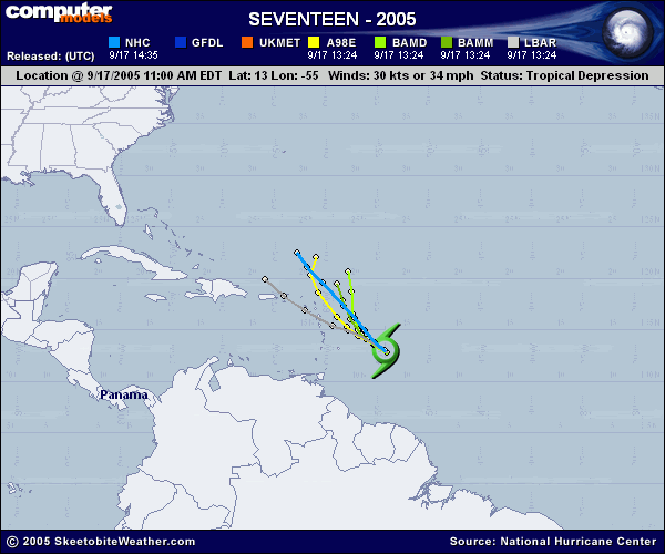
Historical tracks from the 13.0-55w position TD17 is.
0 likes   
Visit the Caribbean-Central America Weather Thread where you can find at first post web cams,radars
and observations from Caribbean basin members Click Here

User avatar
SouthFloridawx
S2K Supporter
S2K Supporter
Posts: 8344
Age: 45
Joined: Tue Jul 26, 2005 1:16 am
Location: Sarasota, FL
Contact:

#43 Postby SouthFloridawx » Sat Sep 17, 2005 9:53 am

Image

this equals uh oh...

:raincloud:
0 likes   

jimbo
Tropical Depression
Tropical Depression
Posts: 62
Joined: Thu Sep 02, 2004 7:34 pm
Location: Elgin, Texas
Contact:

#44 Postby jimbo » Sat Sep 17, 2005 9:55 am

I said last night from the IR and WV that she 'he' was winding up. Buckle your seatbelts Carib/GOM, it's gonna be a bumpy 10 days.

Floater #2 (IR and WV) looks pretty impressive the last few frames as far as circulation getting together. Course it could be my eyes.


Jimbo
0 likes   

User avatar
HurricaneGirl
Category 5
Category 5
Posts: 5839
Age: 59
Joined: Thu Feb 06, 2003 9:45 am
Location: Clare, Michigan
Contact:

#45 Postby HurricaneGirl » Sat Sep 17, 2005 9:57 am

:eek: Holy Crap! Another new depression. :eek:
0 likes   

apocalypt-flyer
Category 1
Category 1
Posts: 468
Joined: Sat Aug 27, 2005 11:51 am

#46 Postby apocalypt-flyer » Sat Sep 17, 2005 9:58 am

Still a lot of uncertainty at the NHC concerning this one, I think.
0 likes   

User avatar
x-y-no
Category 5
Category 5
Posts: 8359
Age: 63
Joined: Wed Aug 11, 2004 12:14 pm
Location: Fort Lauderdale, FL

#47 Postby x-y-no » Sat Sep 17, 2005 9:58 am

Derek makes an interesting observation in his forecast discussion (see analysis forum):

All guidance suggests a track north of the islands. However, it appears as if the guidance is overestimating the southward extent of the trough of low-pressure in the mid and upper levels.


His forecast track is left of the NHC track, but still right of the islands.
0 likes   

scostorms
Tropical Storm
Tropical Storm
Posts: 225
Joined: Mon Aug 29, 2005 8:56 pm
Location: Topeka, Kansas
Contact:

#48 Postby scostorms » Sat Sep 17, 2005 10:02 am

Could 17 continue in that path and slam into NC, or do the hurricanes always curve out into the ocean on a path like that one?
0 likes   

User avatar
skysummit
S2K Supporter
S2K Supporter
Posts: 5305
Age: 48
Joined: Tue Aug 31, 2004 11:09 pm
Location: Ponchatoula, LA
Contact:

#49 Postby skysummit » Sat Sep 17, 2005 10:02 am

scostorms wrote:Could 17 continue in that path and slam into NC, or do the hurricanes always curve out into the ocean on a path like that one?


There is no "always" with tropical systems.
0 likes   

User avatar
cjrciadt
S2K Supporter
S2K Supporter
Posts: 1615
Joined: Mon Aug 22, 2005 1:11 pm
Location: Kissimmee, FL

#50 Postby cjrciadt » Sat Sep 17, 2005 10:24 am

Image Fast intenisfying possible with this system.
0 likes   

Scorpion

#51 Postby Scorpion » Sat Sep 17, 2005 10:25 am

I agree. This also isn't turning north like the NHC says. Just look at the ridge forecast to build in.
0 likes   

Brent
S2K Supporter
S2K Supporter
Posts: 37092
Age: 35
Joined: Sun May 16, 2004 10:30 pm
Location: Tulsa Oklahoma
Contact:

#52 Postby Brent » Sat Sep 17, 2005 10:27 am

scostorms wrote:Could 17 continue in that path and slam into NC, or do the hurricanes always curve out into the ocean on a path like that one?


Could go either way... let's remember that Frances and Isabel both passed well north of the islands but ended up hitting the U.S.

I suspect though... that the NHC track is too far east. I'm thinking if it turns north, it will already be to the islands and then over Puerto Rico and then after that... who knows.
0 likes   
#neversummer

User avatar
cajungal
Category 5
Category 5
Posts: 2203
Age: 47
Joined: Sun Mar 14, 2004 9:34 pm
Location: Schriever, Louisiana (60 miles southwest of New Orleans)

#53 Postby cajungal » Sat Sep 17, 2005 10:40 am

Almost every model is recurving it into a fish. Just a couple of days ago they had it heading west near the Dominican Republic. I don't know if I buy the recurve scererio just yet.
0 likes   

User avatar
cjrciadt
S2K Supporter
S2K Supporter
Posts: 1615
Joined: Mon Aug 22, 2005 1:11 pm
Location: Kissimmee, FL

#54 Postby cjrciadt » Sat Sep 17, 2005 10:44 am

Image
0 likes   

User avatar
WindRunner
Category 5
Category 5
Posts: 5806
Age: 33
Joined: Fri Jul 29, 2005 8:07 pm
Location: Warrenton, VA, but Albany, NY for school
Contact:

#55 Postby WindRunner » Sat Sep 17, 2005 10:47 am

I think that LBAR track seems the most likely for now.
0 likes   

User avatar
vaffie
Category 3
Category 3
Posts: 898
Joined: Sat Sep 11, 2004 5:11 pm
Location: Houston, Texas

#56 Postby vaffie » Sat Sep 17, 2005 10:52 am

I still think it's going to hit or go south of Puerto Rico. Sorry guys.
0 likes   

User avatar
hicksta
Category 5
Category 5
Posts: 1108
Age: 34
Joined: Thu Jul 14, 2005 12:16 am
Location: Kemah Texas/ Baton Rogue LA

#57 Postby hicksta » Sat Sep 17, 2005 10:55 am

Hm, gfdl... Knows storms
0 likes   

Brent
S2K Supporter
S2K Supporter
Posts: 37092
Age: 35
Joined: Sun May 16, 2004 10:30 pm
Location: Tulsa Oklahoma
Contact:

#58 Postby Brent » Sat Sep 17, 2005 10:57 am

The LBAR looks the best to me right now...
0 likes   
#neversummer

apocalypt-flyer
Category 1
Category 1
Posts: 468
Joined: Sat Aug 27, 2005 11:51 am

#59 Postby apocalypt-flyer » Sat Sep 17, 2005 10:59 am

I am with Windrunner and Brent here, I just cannot imagine TD17 turning NNW so quickly ..
0 likes   

Jim Cantore

#60 Postby Jim Cantore » Sat Sep 17, 2005 11:33 am

Image

Looks like the models shifted further north overnight

I tend to agree more with crazy old LBAR the same model that had Katrina bouncing off Cape Canaveral like a pinball then hitting the Carolinas.

I just dont see it moving that far north that quickly
0 likes   


Return to “2005”

Who is online

Users browsing this forum: No registered users and 99 guests