CPAC: LANE - Post-Tropical

Moderator: S2k Moderators

Message
Author
User avatar
Yellow Evan
Professional-Met
Professional-Met
Posts: 15951
Age: 25
Joined: Fri Jul 15, 2011 12:48 pm
Location: Henderson, Nevada/Honolulu, HI
Contact:

Re: EPAC: LANE - Hurricane

#261 Postby Yellow Evan » Sat Aug 18, 2018 9:14 am

TXPZ25 KNES 181314
TCSENP

A. 14E (LANE)

B. 18/1200Z

C. 12.1N

D. 137.4W

E. ONE/GOES-W

F. T6.5/6.5/D2.0/24HRS

G. IR/EIR/SWIR

H. REMARKS...SYSTEM CHARACTERIZED BY A WMG EYE SURROUNDED BY W AND
EMBEDDED IN B FOR A DT=6.5 AFTER ADDING 1.0 FOR AN EYE ADJUSTMENT. MET=6.0
PT=6.5. FT IS BASED ON DT.

I. ADDL POSITIONS

NIL


...FISHER


No SAB this isn't WMG.
0 likes   

User avatar
xtyphooncyclonex
Category 5
Category 5
Posts: 3688
Age: 22
Joined: Sat Dec 08, 2012 9:07 am
Location: Cebu City
Contact:

Re: EPAC: LANE - Hurricane

#262 Postby xtyphooncyclonex » Sat Aug 18, 2018 9:41 am

2 likes   
REMINDER: My opinions that I, or any other NON Pro-Met in this forum, are unofficial. Please do not take my opinions as an official forecast and warning. I am NOT a meteorologist. Following my forecasts blindly may lead to false alarm, danger and risk if official forecasts from agencies are ignored.

User avatar
cycloneye
Admin
Admin
Posts: 139060
Age: 67
Joined: Thu Oct 10, 2002 10:54 am
Location: San Juan, Puerto Rico

Re: EPAC: LANE - Hurricane

#263 Postby cycloneye » Sat Aug 18, 2018 9:52 am

Hurricane Lane Discussion Number 15
NWS National Hurricane Center Miami FL EP142018
800 AM PDT Sat Aug 18 2018

Lane's inner-core convective organization has continued to improve
with satellite intensity estimates vacillating between T6.0/115 kt
and T6.5/127 kt during the past 6 hours. The 15-nmi-diameter eye
remains quiet distinct and is embedded within a solid ring of cloud
tops colder than -70 deg C. An average of the various intensity
estimates from TAFB, SAB, and UW-CIMSS ADT and SATCON support
increasing the intensity to 120 kt.

The initial motion estimate is 285/13 kt. There has been little
change in the models over the past couple of days, and the latest
NHC guidance, especially the consensus track models, required no
significant changes to the previous advisory track. The large
expansive subtropical ridge to the north of the hurricane is
forecast to remain intact and gradually build westward to the north
of the Hawaiian Islands throughout the 120-h forecast period. As a
result, Lane is expected to move west-northwestward for the next 48
hours or so, and then turn westward by day 3, maintaining that
motion on days 4 and 5. The official forecast track lies close to a
blend of the HCCA, TVCE, and FSSE consensus models. On the forecast
track, Hurricane Lane is expected to move into the Central Pacific
basin in about 9 hours at around 0000 UTC.

Although Lane will be remaining over 27.0-27.5 deg C SSTs during
the forecast period, increasing westerly to northwesterly vertical
wind shear to around 15 kt, along with a slightly drier mid-level
environment, is expected to induce slow but steady weakening by 24
hours. Although Lane could strengthen a little more before the
prolonged weakening begins, the general intensity trend should be
downward. However, the rate of weakening is held a little above the
intensity guidance owing to the warmer SSTs indicated by raw data
than what the SHIPS model guidance is using.

FORECAST POSITIONS AND MAX WINDS

INIT 18/1500Z 12.3N 138.2W 120 KT 140 MPH
12H 19/0000Z 12.8N 140.0W 120 KT 140 MPH
24H 19/1200Z 13.4N 142.3W 115 KT 130 MPH
36H 20/0000Z 13.8N 144.3W 110 KT 125 MPH
48H 20/1200Z 14.1N 146.3W 105 KT 120 MPH
72H 21/1200Z 14.5N 150.1W 95 KT 110 MPH
96H 22/1200Z 14.9N 153.5W 80 KT 90 MPH
120H 23/1200Z 15.8N 157.0W 65 KT 75 MPH

$$
Forecaster Stewart
0 likes   
Visit the Caribbean-Central America Weather Thread where you can find at first post web cams,radars
and observations from Caribbean basin members Click Here

User avatar
Yellow Evan
Professional-Met
Professional-Met
Posts: 15951
Age: 25
Joined: Fri Jul 15, 2011 12:48 pm
Location: Henderson, Nevada/Honolulu, HI
Contact:

Re: EPAC: LANE - Hurricane

#264 Postby Yellow Evan » Sat Aug 18, 2018 9:54 am

Why has the NHC kept the pressure at 948 mbar despite raising the intensity?
0 likes   

ncapps
Tropical Storm
Tropical Storm
Posts: 105
Joined: Wed Aug 15, 2018 7:53 am

Re: EPAC: LANE - Hurricane

#265 Postby ncapps » Sat Aug 18, 2018 10:10 am

The NHc sounds prett confident in the synoptic setup for the long range. I guess there not giving much thought to the GFS?
0 likes   

Ntxw
Storm2k Moderator
Storm2k Moderator
Posts: 21501
Joined: Wed Oct 21, 2009 6:34 pm
Location: DFW, Texas

Re: EPAC: LANE - Hurricane

#266 Postby Ntxw » Sat Aug 18, 2018 10:50 am

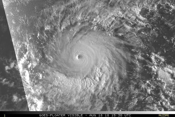
Epac gives us another gorgeous view. Should get full panel visible soon

Image
4 likes   
The above post and any post by Ntxw is NOT an official forecast and should not be used as such. It is just the opinion of the poster and may or may not be backed by sound meteorological data. It is NOT endorsed by any professional institution including Storm2k. For official information, please refer to NWS products.

  Help support Storm2K!
Help Support Storm2K

User avatar
Siker
Category 4
Category 4
Posts: 904
Age: 27
Joined: Thu Oct 25, 2012 7:36 pm
Location: Miami, FL

Re: EPAC: LANE - Hurricane

#267 Postby Siker » Sat Aug 18, 2018 11:29 am

Latest UKMET shifts south:

Image
0 likes   

ncapps
Tropical Storm
Tropical Storm
Posts: 105
Joined: Wed Aug 15, 2018 7:53 am

Re: EPAC: LANE - Hurricane

#268 Postby ncapps » Sat Aug 18, 2018 12:32 pm

HMON is really far south. Not even a rain threat to Hawaii potentially.

HWRF keeps it strong, but tracks just due west, very south as well.
0 likes   

User avatar
1900hurricane
Category 5
Category 5
Posts: 6044
Age: 32
Joined: Fri Feb 06, 2015 12:04 pm
Location: Houston, TX
Contact:

Re: EPAC: LANE - Hurricane

#269 Postby 1900hurricane » Sat Aug 18, 2018 1:18 pm

Yellow Evan wrote:Why has the NHC kept the pressure at 948 mbar despite raising the intensity?

Looks like it's basically a KZC pressure estimate. I get 950 mb and 949 mb when I run my two versions of KZC on the b deck.
0 likes   
Contract Meteorologist. TAMU & MSST. Fiercely authentic, one of a kind. We are all given free will, so choose a life meant to be lived. We are the Masters of our own Stories.
Opinions expressed are mine alone.

Follow me on Twitter at @1900hurricane : Read blogs at https://1900hurricane.wordpress.com/

User avatar
NDG
S2K Supporter
S2K Supporter
Posts: 14933
Joined: Sun Jul 09, 2006 10:14 pm
Location: Orlando, FL

Re: EPAC: LANE - Hurricane

#270 Postby NDG » Sat Aug 18, 2018 1:22 pm

I don’t understand why so many have been dismissing the Euro’s forecast track when it did fairly good with Hector while the GFS was north biased at times.
0 likes   

ncapps
Tropical Storm
Tropical Storm
Posts: 105
Joined: Wed Aug 15, 2018 7:53 am

Re: EPAC: LANE - Hurricane

#271 Postby ncapps » Sat Aug 18, 2018 1:25 pm

NDG wrote:I don’t understand why so many have been dismissing the Euro’s forecast track when it did fairly good with Hector while the GFS was north biased at times.


I don't think the NHC is dismissing it. Their track is mostly based on the Euro, no real mention of the north track in the latest discussion.
0 likes   

User avatar
Kingarabian
S2K Supporter
S2K Supporter
Posts: 15434
Joined: Sat Aug 08, 2009 3:06 am
Location: Honolulu, Hawaii

Re: EPAC: LANE - Hurricane

#272 Postby Kingarabian » Sat Aug 18, 2018 1:29 pm

12z Euro is more north and stronger through hour 120.
0 likes   
RIP Kobe Bryant

ncapps
Tropical Storm
Tropical Storm
Posts: 105
Joined: Wed Aug 15, 2018 7:53 am

Re: EPAC: LANE - Hurricane

#273 Postby ncapps » Sat Aug 18, 2018 1:30 pm

Kingarabian wrote:12z Euro is more north and stronger through hour 120.


Stronger, and a little more north, but not much to see here and pretty similar to the HMON/HWRF.

Image
0 likes   

User avatar
Kingarabian
S2K Supporter
S2K Supporter
Posts: 15434
Joined: Sat Aug 08, 2009 3:06 am
Location: Honolulu, Hawaii

Re: EPAC: LANE - Hurricane

#274 Postby Kingarabian » Sat Aug 18, 2018 1:37 pm

NDG wrote:I don’t understand why so many have been dismissing the Euro’s forecast track when it did fairly good with Hector while the GFS was north biased at times.


Because it continues to initialize Lane as a 997mb TS and keeps it as a TS through 60 hours.
0 likes   
RIP Kobe Bryant

User avatar
Kingarabian
S2K Supporter
S2K Supporter
Posts: 15434
Joined: Sat Aug 08, 2009 3:06 am
Location: Honolulu, Hawaii

Re: EPAC: LANE - Hurricane

#275 Postby Kingarabian » Sat Aug 18, 2018 1:38 pm

ncapps wrote:
Kingarabian wrote:12z Euro is more north and stronger through hour 120.


Stronger, and a little more north, but not much to see here and pretty similar to the HMON/HWRF.

[img]https://www.weathernerds.org/models/v3.0/ecmwf/sessions/ecmwf_2018-08-18-12Z_144_26.667_192.74_11.615_207.383_MSLP_Surface.png[mg]


By going with yesterdays trends, it will probably mean that there will be more EPS shifts.
0 likes   
RIP Kobe Bryant

User avatar
Kingarabian
S2K Supporter
S2K Supporter
Posts: 15434
Joined: Sat Aug 08, 2009 3:06 am
Location: Honolulu, Hawaii

Re: EPAC: LANE - Hurricane

#276 Postby Kingarabian » Sat Aug 18, 2018 2:51 pm

Kingarabian wrote:
ncapps wrote:
Kingarabian wrote:12z Euro is more north and stronger through hour 120.


Stronger, and a little more north, but not much to see here and pretty similar to the HMON/HWRF.

[img]https://www.weathernerds.org/models/v3.0/ecmwf/sessions/ecmwf_2018-08-18-12Z_144_26.667_192.74_11.615_207.383_MSLP_Surface.png[mg]


By going with yesterdays trends, it will probably mean that there will be more EPS shifts.


Pretty good EPS run, as none of the members take it close to Hawaii. Any recurves are well west of Kauai. I'm still wary on the fact that ECMWF package continues to have a wrong information input and that their solutions are possibly skewered due to a Category 4 hurricane being modeled out as a tropical storm for 60 hours.

While 12z GFS did have an Kauai landfall, it came in more west and south vs the 06z/00z GFS runs. Hopefully this trend continues and it shifts away from Hawaii.
0 likes   
RIP Kobe Bryant

ncapps
Tropical Storm
Tropical Storm
Posts: 105
Joined: Wed Aug 15, 2018 7:53 am

Re: EPAC: LANE - Hurricane

#277 Postby ncapps » Sat Aug 18, 2018 3:09 pm

Kingarabian wrote:
Kingarabian wrote:
ncapps wrote:
Stronger, and a little more north, but not much to see here and pretty similar to the HMON/HWRF.

[img]https://www.weathernerds.org/models/v3.0/ecmwf/sessions/ecmwf_2018-08-18-12Z_144_26.667_192.74_11.615_207.383_MSLP_Surface.png[mg]


By going with yesterdays trends, it will probably mean that there will be more EPS shifts.


Pretty good EPS run, as none of the members take it close to Hawaii. Any recurves are well west of Kauai. I'm still wary on the fact that ECMWF package continues to have a wrong information input and that their solutions are possibly skewered due to a Category 4 hurricane being modeled out as a tropical storm for 60 hours.

While 12z GFS did have an Kauai landfall, it came in more west and south vs the 06z/00z GFS runs. Hopefully this trend continues and it shifts away from Hawaii.


The GFS ensembles after Day 5 are comical. Hopefully its gets a handle on things tomorrow. Euro meanwhile has not really flinched.

Image
1 likes   

User avatar
NDG
S2K Supporter
S2K Supporter
Posts: 14933
Joined: Sun Jul 09, 2006 10:14 pm
Location: Orlando, FL

Re: EPAC: LANE - Hurricane

#278 Postby NDG » Sat Aug 18, 2018 3:18 pm

Kingarabian wrote:
NDG wrote:I don’t understand why so many have been dismissing the Euro’s forecast track when it did fairly good with Hector while the GFS was north biased at times.


Because it continues to initialize Lane as a 997mb TS and keeps it as a TS through 60 hours.


When ridging is strong to the north and there's a deep easterly flow from the low levels to the mid levels it does not matter much how strong the storm is. IMO.
In the past I have seen many people dismiss the forecast track of a model because it does not initiate the correct strength of a storm but it ends up being correct.
The difference in this matter between the two models is that the GFS forecasts Lane to move slower and forecasts the mid level ridge to weaken at the 5 day range while the Euro does the opposite.
0 likes   

User avatar
Kingarabian
S2K Supporter
S2K Supporter
Posts: 15434
Joined: Sat Aug 08, 2009 3:06 am
Location: Honolulu, Hawaii

Re: EPAC: LANE - Hurricane

#279 Postby Kingarabian » Sat Aug 18, 2018 3:32 pm

NDG wrote:
Kingarabian wrote:
NDG wrote:I don’t understand why so many have been dismissing the Euro’s forecast track when it did fairly good with Hector while the GFS was north biased at times.


Because it continues to initialize Lane as a 997mb TS and keeps it as a TS through 60 hours.


When ridging is strong to the north and there's a deep easterly flow from the low levels to the mid levels it does not matter much how strong the storm is. IMO.
In the past I have seen many people dismiss the forecast track of a model because it does not initiate the correct strength of a storm but it ends up being correct.
The difference in this matter between the two models is that the GFS forecasts Lane to move slower and forecasts the mid level ridge to weaken at the 5 day range while the Euro does the opposite.


I understand that the Euro does not always initialize the storm correct and that usually does not affect its track solution, but it's not just initializing the storm wrong. It's also keeping the storm weak for an extended period of time (up to 60 hours) and then starts to strengthen to it later. The UKMET is handling Lane's intensity much better, and also keeps a stronger Lane than the Euro and thus shows considerably more poleward motion.
0 likes   
RIP Kobe Bryant

User avatar
Kingarabian
S2K Supporter
S2K Supporter
Posts: 15434
Joined: Sat Aug 08, 2009 3:06 am
Location: Honolulu, Hawaii

Re: EPAC: LANE - Hurricane

#280 Postby Kingarabian » Sat Aug 18, 2018 3:36 pm

TXPZ25 KNES 181825
TCSENP

A. 14E (LANE)

B. 18/1800Z

C. 12.5N

D. 138.9W

E. ONE/GOES-W

F. T6.0/6.5/D1.0/24HRS

G. IR/EIR/VIS

H. REMARKS...SYSTEM CHARACTERIZED BY A WMG EYE SURROUNDED BY B AND
EMBEDDED IN LG FOR A DT 6.0 AFTER ADDING 1.0 FOR AN EYE ADJUSTMENT. MET
AND PT ARE 6.0. FT IS BASED ON DT.

I. ADDL POSITIONS

NIL


...FISHER
0 likes   
RIP Kobe Bryant


Return to “2018”

Who is online

Users browsing this forum: No registered users and 103 guests