
I got to go with climatology on this one and say safely away from US coastline.
ATL: SAM - Models
Moderator: S2k Moderators
Re: ATL: INVEST 98L - Models
I got to go with climatology on this one and say safely away from US coastline.
2 likes

-
Hypercane_Kyle

- Category 5

- Posts: 3465
- Joined: Sat Mar 07, 2015 7:58 pm
- Location: Cape Canaveral, FL
Re: ATL: INVEST 98L - Models
It's incredibly, incredibly hard to get a storm nearly at 30W to hit the CONUS this time of year. Odds of significant impacts from future Sam, while not completely impossible, appear much slimmer today.
3 likes
My posts are my own personal opinion, defer to the National Hurricane Center (NHC) and other NOAA products for decision making during hurricane season.
-
Shell Mound
- Category 5
- Posts: 2432
- Age: 33
- Joined: Thu Sep 07, 2017 3:39 pm
- Location: St. Petersburg, FL → Scandinavia
Re: ATL: INVEST 98L - Models
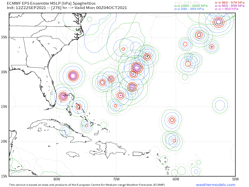
Even so, roughly four-fifths of the fifty-one ensemble members show either OTS or impacts to Bermuda. Most even pass to the north of the Caribbean.
0 likes
CVW / MiamiensisWx / Shell Mound
The posts in this forum are NOT official forecasts and should not be used as such. They are just the opinion of the poster and may or may not be backed by sound meteorological data. They are NOT endorsed by any professional institution or STORM2K. For official information, please refer to products from the NHC and NWS.
Re: ATL: INVEST 98L - Models
Hypercane_Kyle wrote:It's incredibly, incredibly hard to get a storm nearly at 30W to hit the CONUS this time of year. Odds of significant impacts from future Sam, while not completely impossible, appear much slimmer today.
Statistically it's incredibly hard to get a storm at 30W to hit the CONUS any time of year.
In October, history tells us it's almost impossible
5 likes

Re: ATL: INVEST 98L - Models
Hypercane_Kyle wrote:It's incredibly, incredibly hard to get a storm nearly at 30W to hit the CONUS this time of year. Odds of significant impacts from future Sam, while not completely impossible, appear much slimmer today.
I know everyone’s focused on either the CONUS or the Lesser Antilles, but this could be a significant problem for Bermuda if the more SW tracks verify. I’m not worried about the CONUS yet because it’s so far out and, as you and others have said, climo is on our side this late in the season.
IMO, it’s probably best to wait another day or two until 98L has a better defined LLC to give more merit to possible tracks past 60W. 98L could get further north quicker and be OTS like the GFS, or it could retain a W/WNW motion for longer and be a threat or close call for the Leeward Islands like the Euro.
3 likes
Irene '11 Sandy '12 Hermine '16 5/15/2018 Derecho Fay '20 Isaias '20 Elsa '21 Henri '21 Ida '21
I am only a meteorology enthusiast who knows a decent amount about tropical cyclones. Look to the professional mets, the NHC, or your local weather office for the best information.
I am only a meteorology enthusiast who knows a decent amount about tropical cyclones. Look to the professional mets, the NHC, or your local weather office for the best information.

Re: ATL: INVEST 98L - Models
https://twitter.com/webberweather/status/1440766291787145216
This is a long way from being decided. This will swing back and forth.
This is a long way from being decided. This will swing back and forth.
7 likes
The following post is NOT an official forecast and should not be used as such. It is just the opinion of the poster and may or may not be backed by sound meteorological data. It is NOT endorsed by any professional institution including storm2k.org For Official Information please refer to the NHC and NWS products.

Re: ATL: INVEST 98L - Models
When are people gonna learn clinging to climotology and treating 200+ hour model runs as deterministic is a bad idea?
8 likes
-
Category5Kaiju

- Category 5
- Posts: 4334
- Joined: Thu Dec 24, 2020 12:45 pm
- Location: Seattle and Phoenix
Re: ATL: INVEST 98L - Models
blp wrote:https://twitter.com/webberweather/status/1440766291787145216?ref_src=twsrc%5Etfw%7Ctwcamp%5Etweetembed%7Ctwterm%5E1440766291787145216%7Ctwgr%5E%7Ctwcon%5Es1_c10&ref_url=https%3A%2F%2Fpublish.twitter.com%2F%3Fquery%3Dhttps3A2F2Ftwitter.com2Fwebberweather2Fstatus2F1440766291787145216widget%3DTweet
This is a long way from being decided. This will swing back and forth.
Looks like those ensembles have two distinct clusters: a sharp recurve east of the islands or a continued WNW track. Hmm...
3 likes
Unless explicitly stated, all info in my posts is based on my own opinions and observations. Tropical storms and hurricanes can be extremely dangerous. Refer to an accredited weather research agency or meteorologist if you need to make serious decisions regarding an approaching storm.
-
Shell Mound
- Category 5
- Posts: 2432
- Age: 33
- Joined: Thu Sep 07, 2017 3:39 pm
- Location: St. Petersburg, FL → Scandinavia
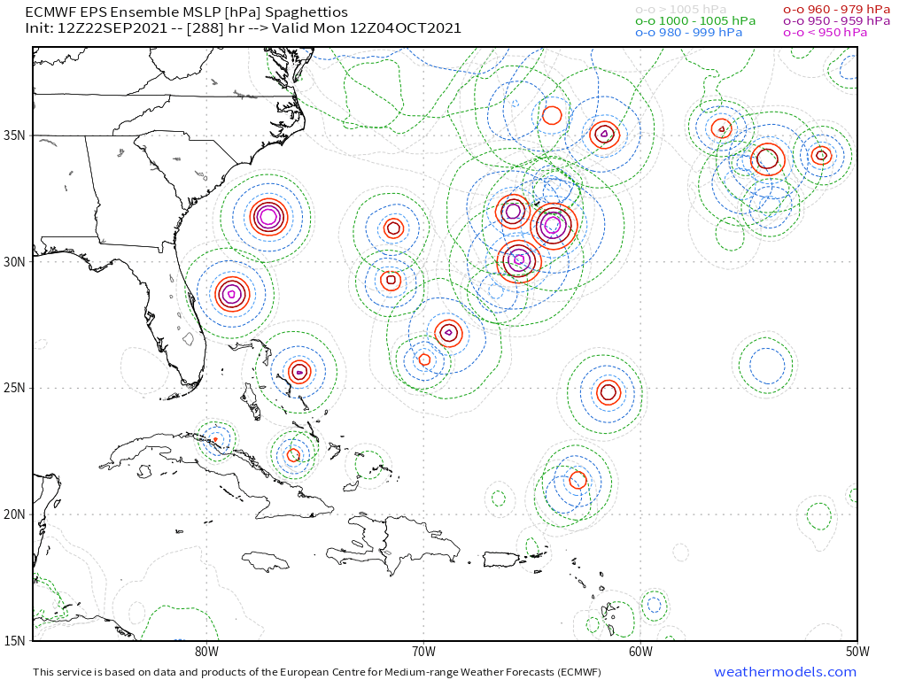
Re: ATL: EIGHTEEN - Models

The above screenshot shows the EPS members through D7 (168h). The members that show a hurricane at or before this time all pass to the north of the islands.
0 likes
CVW / MiamiensisWx / Shell Mound
The posts in this forum are NOT official forecasts and should not be used as such. They are just the opinion of the poster and may or may not be backed by sound meteorological data. They are NOT endorsed by any professional institution or STORM2K. For official information, please refer to products from the NHC and NWS.
-
skyline385

- Category 5
- Posts: 2728
- Age: 35
- Joined: Wed Aug 26, 2020 11:15 pm
- Location: Houston TX
Re: ATL: EIGHTEEN - Models
Shell Mound wrote:
The above screenshot shows the EPS members through D7 (168h). The members that show a hurricane at or before this time all pass to the north of the islands.
That's a very good observation. With the NHC even predicting a major at D5, it seems very likely that all solutions will start converging to a recurve...
0 likes
-
Spacecoast

- Category 2

- Posts: 773
- Joined: Thu Aug 31, 2017 2:03 pm
Re: ATL: EIGHTEEN - Models
12z ECMF: Operational now NE of ensemble mean through hr 216.

12z GEFS: Operational NE of ens mean

12z GEFS: Operational NE of ens mean
0 likes
-
StormPyrate
- Category 1

- Posts: 286
- Joined: Sun May 27, 2018 8:41 pm
- Location: Clearwater, FL
Re: ATL: INVEST 98L - Models
Zonacane wrote:When are people gonna learn clinging to climotology and treating 200+ hour model runs as deterministic is a bad idea?
when climatology becomes irrelevant, and we are no where near that point.
Been watching these things for a long time. And the beginning of cold front season in Florida means the chances drop for a direct impact from across the ocean.
By no means out of the woods, could still have something pop up closer to home.
0 likes
St Petersburg Florida
-
skyline385
- Category 5
- Posts: 2728
- Age: 35
- Joined: Wed Aug 26, 2020 11:15 pm
- Location: Houston TX
-
Blown Away

- S2K Supporter

- Posts: 10253
- Joined: Wed May 26, 2004 6:17 am
Re: ATL: EIGHTEEN - Models

18z GFS +150 hrs... HP a little stronger and trough a bit weaker...
0 likes
Hurricane Eye Experience: David 79, Irene 99, Frances 04, Jeanne 04, Wilma 05… Hurricane Brush Experience: Andrew 92, Erin 95, Floyd 99, Matthew 16, Irma 17, Ian 22, Nicole 22…

Re: ATL: EIGHTEEN - Models
0 likes
TC naming lists: retirements and intensity
Most aggressive Advisory #1's in North Atlantic (cr. kevin for starting the list)
Most aggressive Advisory #1's in North Atlantic (cr. kevin for starting the list)
-
Blown Away
- S2K Supporter
- Posts: 10253
- Joined: Wed May 26, 2004 6:17 am
Re: ATL: EIGHTEEN - Models

18z GFS+174 hrs... @200 mile S shift at 174 hrs...
0 likes
Hurricane Eye Experience: David 79, Irene 99, Frances 04, Jeanne 04, Wilma 05… Hurricane Brush Experience: Andrew 92, Erin 95, Floyd 99, Matthew 16, Irma 17, Ian 22, Nicole 22…
-
Blown Away
- S2K Supporter
- Posts: 10253
- Joined: Wed May 26, 2004 6:17 am
Re: ATL: EIGHTEEN - Models

18z vs 12z GFS Trend... Huge S shift.
0 likes
Hurricane Eye Experience: David 79, Irene 99, Frances 04, Jeanne 04, Wilma 05… Hurricane Brush Experience: Andrew 92, Erin 95, Floyd 99, Matthew 16, Irma 17, Ian 22, Nicole 22…
-
Hurricaneman

- Category 5
- Posts: 7404
- Age: 45
- Joined: Tue Aug 31, 2004 3:24 pm
- Location: central florida
-
SouthFLTropics

- Category 5
- Posts: 4258
- Age: 50
- Joined: Thu Aug 14, 2003 8:04 am
- Location: Port St. Lucie, Florida
Re: ATL: EIGHTEEN - Models
Despite it being further south, it appears that there is a clear exit. Trap door open.
2 likes
Fourth Generation Florida Native
Personal Storm History: David 79, Andrew 92, Erin 95, Floyd 99, Irene 99, Frances 04, Jeanne 04, Wilma 05, Matthew 16, Irma 17, Ian 22, Nicole 22, Milton 24
Personal Storm History: David 79, Andrew 92, Erin 95, Floyd 99, Irene 99, Frances 04, Jeanne 04, Wilma 05, Matthew 16, Irma 17, Ian 22, Nicole 22, Milton 24
Who is online
Users browsing this forum: No registered users and 48 guests