ATL: TROPICAL DEPRESSION DANNY (05L)
Moderator: S2k Moderators
Re: ATL : Invest 92L - Recon Thread
Needs to get south of 22 to have a chance at a west wind.
0 likes
Re: ATL: Invest 92L
ABNT20 KNHC 252317
TWOAT
TROPICAL WEATHER OUTLOOK
NWS TPC/NATIONAL HURRICANE CENTER MIAMI FL
800 PM EDT TUE AUG 25 2009
FOR THE NORTH ATLANTIC...CARIBBEAN SEA AND THE GULF OF MEXICO...
AN AIR FORCE RESERVE RECONNAISSANCE AIRCRAFT INVESTIGATING THE AREA
OF DISTURBED WEATHER ABOUT 350 MILES NORTH OF SAN JUAN PUERTO RICO
FOUND A SURFACE TROUGH OF LOW PRESSURE BUT DID NOT FIND A CLOSED
CIRCULATION. HOWEVER...THE AIRCRAFT DID REPORT GALE-FORCE WINDS IN
THE AREA. UPPER-LEVEL WINDS ARE FORECAST TO BECOME MORE CONDUCIVE
FOR DEVELOPMENT...AND THIS SYSTEM HAS THE POTENTIAL TO BECOME A
TROPICAL STORM AT ANY TIME AS IT CONTINUES MOVING WEST-NORTHWESTWARD
AROUND 20 MPH. THERE IS A HIGH CHANCE...GREATER THAN 50 PERCENT...
OF TROPICAL CYCLONE FORMATION DURING THE NEXT 48 HOURS. INTERESTS
IN THE BAHAMAS SHOULD MONITOR THE PROGRESS OF THIS SYSTEM.
ADDITIONAL INFORMATION ON MARINE WARNINGS ASSOCIATED WITH THIS
SYSTEM CAN BE FOUND IN HIGH SEAS FORECASTS ISSUED BY THE NATIONAL
WEATHER SERVICE...UNDER AWIPS HEADER NFDHSFAT1 AND WMO HEADER
FZNT01 KWBC.
ELSEWHERE...TROPICAL CYCLONE FORMATION IS NOT EXPECTED DURING THE
NEXT 48 HOURS.
$$
FORECASTER PASCH/BERG
A very early TWO, put out at 7:17 PM.
Edited to show complete message.
0 likes
-
cycloneye

- Admin

- Posts: 149399
- Age: 69
- Joined: Thu Oct 10, 2002 10:54 am
- Location: San Juan, Puerto Rico
Re: ATL : Invest 92L - Recon Thread
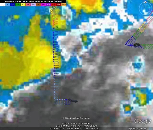
For the first time plane gets south winds.
URNT15 KNHC 252320
AF302 01AAA INVEST HDOB 28 20090825
231030 2217N 06730W 9770 00299 0109 +225 +194 106009 009 023 000 00
231100 2215N 06730W 9769 00299 0109 +227 +193 118008 008 020 001 00
231130 2213N 06730W 9769 00298 0109 +231 +193 123008 008 023 000 00
231200 2211N 06730W 9770 00298 0109 +230 +193 116008 008 025 000 03
231230 2209N 06730W 9772 00297 0108 +233 +194 140007 008 023 000 00
231300 2208N 06730W 9771 00297 0109 +228 +195 119006 007 023 000 00
231330 2206N 06730W 9768 00301 0109 +230 +195 131006 006 024 000 00
231400 2204N 06730W 9771 00298 0108 +233 +195 140006 007 015 003 00
231430 2202N 06730W 9770 00298 0108 +235 +195 153007 008 011 004 00
231500 2201N 06730W 9774 00295 0108 +240 +196 171008 008 011 004 03
231530 2200N 06728W 9772 00297 0108 +238 +197 177008 009 006 003 03
231600 2200N 06726W 9772 00297 0109 +235 +198 179007 007 013 004 00
231630 2200N 06724W 9772 00297 0108 +235 +199 180009 009 018 002 00
231700 2200N 06722W 9772 00297 0109 +236 +200 175008 010 014 003 00
231730 2200N 06720W 9768 00300 0108 +238 +200 184009 010 013 003 00
231800 2200N 06718W 9772 00296 0108 +237 +201 175009 010 015 003 00
231830 2200N 06716W 9769 00299 0108 +237 +201 175010 011 014 003 00
231900 2200N 06715W 9768 00300 0108 +239 +201 176011 011 015 002 00
231930 2200N 06713W 9772 00297 0108 +240 +202 174010 011 016 002 00
232000 2200N 06711W 9765 00302 0108 +237 +202 178011 012 014 003 00
0 likes
-
cycloneye
- Admin
- Posts: 149399
- Age: 69
- Joined: Thu Oct 10, 2002 10:54 am
- Location: San Juan, Puerto Rico
Re: ATL: Invest 92L
AND THIS SYSTEM HAS THE POTENTIAL TO BECOME A
TROPICAL STORM AT ANY TIME
Skipping TD status.
TROPICAL STORM AT ANY TIME
Skipping TD status.
0 likes
-
'CaneFreak

- Category 5

- Posts: 1487
- Joined: Mon Jun 05, 2006 10:50 am
- Location: New Bern, NC


-
'CaneFreak
- Category 5
- Posts: 1487
- Joined: Mon Jun 05, 2006 10:50 am
- Location: New Bern, NC
-
Jevo

- S2K Supporter

- Posts: 1729
- Age: 47
- Joined: Tue Aug 03, 2004 8:45 pm
- Location: The Flemish Cap
- Contact:
Re: ATL: Invest 92L
cycloneye wrote:AND THIS SYSTEM HAS THE POTENTIAL TO BECOME A
TROPICAL STORM AT ANY TIME
Skipping TD status.
That would make sense if they are already reporting Gale winds in the storm. If it were to wrap up with Gale force winds that would classify it as a TS right off the bat..
Beaufort Scale Description of a Gale Wind
39 – 46 MPH
0 likes
-
cycloneye
- Admin
- Posts: 149399
- Age: 69
- Joined: Thu Oct 10, 2002 10:54 am
- Location: San Juan, Puerto Rico
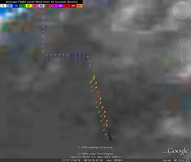
Re: ATL : Invest 92L - Recon Thread
SW Winds found
URNT15 KNHC 252330
AF302 01AAA INVEST HDOB 29 20090825
232030 2200N 06709W 9594 00452 0105 +224 +201 173011 012 010 004 03
232100 2159N 06708W 9392 00644 0109 +212 +200 172009 010 020 002 03
232130 2157N 06707W 9164 00863 0117 +205 +196 179009 010 019 001 03
232200 2155N 06707W 8754 01275 0125 +194 +191 206007 008 999 999 03
232230 2155N 06707W 8754 01275 0126 +172 +172 211009 010 999 999 03
232300 2152N 06706W 7982 02071 9990 +150 +999 195015 018 999 999 05
232330 2150N 06705W 7566 02503 9990 +129 +999 207021 023 999 999 05
232400 2149N 06705W 7246 02865 9990 +111 +999 214023 024 017 002 05
232430 2147N 06704W 7058 03088 9990 +093 +999 223024 024 013 002 01
232500 2145N 06704W 6966 03195 9990 +085 +999 226023 024 010 003 01
232530 2143N 06703W 6967 03195 9990 +086 +999 227026 026 013 002 01
232600 2141N 06703W 6967 03197 0117 +086 -072 228025 025 014 002 00
232630 2140N 06702W 6969 03192 0118 +088 -100 221023 024 013 002 00
232700 2138N 06702W 6967 03198 0119 +088 -100 215021 021 016 001 00
232730 2136N 06701W 6968 03194 0119 +089 -100 212021 021 016 001 00
232800 2134N 06700W 6966 03196 0121 +086 -100 215021 021 009 003 00
232830 2132N 06700W 6967 03195 0121 +085 -100 213021 021 012 003 00
232900 2130N 06659W 6967 03200 0121 +088 -100 208022 022 015 002 00
232930 2128N 06659W 6967 03196 0119 +090 -100 207022 022 014 002 00
233000 2126N 06658W 6816 03384 0123 +078 -100 209023 024 014 002 00
$$
0 likes
-
Blown Away

- S2K Supporter
- Posts: 10253
- Joined: Wed May 26, 2004 6:17 am
Re: ATL : Invest 92L - Recon Thread
cycloneye wrote:For the first time plane gets south winds.
URNT15 KNHC 252320
AF302 01AAA INVEST HDOB 28 20090825
231030 2217N 06730W 9770 00299 0109 +225 +194 106009 009 023 000 00
231100 2215N 06730W 9769 00299 0109 +227 +193 118008 008 020 001 00
231130 2213N 06730W 9769 00298 0109 +231 +193 123008 008 023 000 00
231200 2211N 06730W 9770 00298 0109 +230 +193 116008 008 025 000 03
231230 2209N 06730W 9772 00297 0108 +233 +194 140007 008 023 000 00
231300 2208N 06730W 9771 00297 0109 +228 +195 119006 007 023 000 00
231330 2206N 06730W 9768 00301 0109 +230 +195 131006 006 024 000 00
231400 2204N 06730W 9771 00298 0108 +233 +195 140006 007 015 003 00
231430 2202N 06730W 9770 00298 0108 +235 +195 153007 008 011 004 00
231500 2201N 06730W 9774 00295 0108 +240 +196 171008 008 011 004 03
231530 2200N 06728W 9772 00297 0108 +238 +197 177008 009 006 003 03
231600 2200N 06726W 9772 00297 0109 +235 +198 179007 007 013 004 00
231630 2200N 06724W 9772 00297 0108 +235 +199 180009 009 018 002 00
231700 2200N 06722W 9772 00297 0109 +236 +200 175008 010 014 003 00
231730 2200N 06720W 9768 00300 0108 +238 +200 184009 010 013 003 00
231800 2200N 06718W 9772 00296 0108 +237 +201 175009 010 015 003 00
231830 2200N 06716W 9769 00299 0108 +237 +201 175010 011 014 003 00
231900 2200N 06715W 9768 00300 0108 +239 +201 176011 011 015 002 00
231930 2200N 06713W 9772 00297 0108 +240 +202 174010 011 016 002 00
232000 2200N 06711W 9765 00302 0108 +237 +202 178011 012 014 003 00
Luis, do you think this is the circulation center near the 67-68W vorticy?
0 likes
Re: ATL : Invest 92L - Recon Thread
They've gone out of mission profile and are headed home (unless they are increasing altitude due to the higher winds they were in earlier).
Last edited by clfenwi on Tue Aug 25, 2009 6:36 pm, edited 1 time in total.
0 likes
-
cycloneye
- Admin
- Posts: 149399
- Age: 69
- Joined: Thu Oct 10, 2002 10:54 am
- Location: San Juan, Puerto Rico
Re: ATL: Invest 92L
SW winds found below 22N.
Plane climbing when those were found so not at surface.
Plane climbing when those were found so not at surface.
0 likes

Re: ATL : Invest 92L - Recon Thread
Unfortunately, those southwest winds began with the aircraft climbing to head home. They weren't near the surface.cycloneye wrote:SW Winds found
URNT15 KNHC 252330
AF302 01AAA INVEST HDOB 29 20090825
232030 2200N 06709W 9594 00452 0105 +224 +201 173011 012 010 004 03
232100 2159N 06708W 9392 00644 0109 +212 +200 172009 010 020 002 03
232130 2157N 06707W 9164 00863 0117 +205 +196 179009 010 019 001 03
232200 2155N 06707W 8754 01275 0125 +194 +191 206007 008 999 999 03
232230 2155N 06707W 8754 01275 0126 +172 +172 211009 010 999 999 03
232300 2152N 06706W 7982 02071 9990 +150 +999 195015 018 999 999 05
232330 2150N 06705W 7566 02503 9990 +129 +999 207021 023 999 999 05
232400 2149N 06705W 7246 02865 9990 +111 +999 214023 024 017 002 05
232430 2147N 06704W 7058 03088 9990 +093 +999 223024 024 013 002 01
232500 2145N 06704W 6966 03195 9990 +085 +999 226023 024 010 003 01
232530 2143N 06703W 6967 03195 9990 +086 +999 227026 026 013 002 01
232600 2141N 06703W 6967 03197 0117 +086 -072 228025 025 014 002 00
232630 2140N 06702W 6969 03192 0118 +088 -100 221023 024 013 002 00
232700 2138N 06702W 6967 03198 0119 +088 -100 215021 021 016 001 00
232730 2136N 06701W 6968 03194 0119 +089 -100 212021 021 016 001 00
232800 2134N 06700W 6966 03196 0121 +086 -100 215021 021 009 003 00
232830 2132N 06700W 6967 03195 0121 +085 -100 213021 021 012 003 00
232900 2130N 06659W 6967 03200 0121 +088 -100 208022 022 015 002 00
232930 2128N 06659W 6967 03196 0119 +090 -100 207022 022 014 002 00
233000 2126N 06658W 6816 03384 0123 +078 -100 209023 024 014 002 00
$$
0 likes
Re: ATL : Invest 92L - Recon Thread
The past tense wording of the TWO indicated that they considered the area of interest to be fully covered.
0 likes
-
storms NC

- Tropical Storm

- Posts: 247
- Age: 70
- Joined: Tue Sep 14, 2004 2:41 pm
- Location: Coast of NC & southwest coast of Fla
Re: ATL: Invest 92L
Jevo wrote:HURAKAN wrote:
Hooray Slack-U-Weather
Image shows a TS Parallel to Cape Canaveral going straight for Cape Cod....
PS HURAKAN.. not kocking you... I know youre just posting the info

I think it is just a little to far to the east.
0 likes

-
Jevo
- S2K Supporter
- Posts: 1729
- Age: 47
- Joined: Tue Aug 03, 2004 8:45 pm
- Location: The Flemish Cap
- Contact:
Re: ATL: Invest 92L
cycloneye wrote:SW winds found below 22N.
Plane climbing when those were found so not at surface.
I was agreeing with you that it would bypass... are you saying it shouldnt? Sorry Im not completly following your train of thought.
Last edited by Jevo on Tue Aug 25, 2009 6:41 pm, edited 1 time in total.
0 likes
Who is online
Users browsing this forum: No registered users and 149 guests