
ATL: IKE Discussion
Moderator: S2k Moderators
-
cycloneye

- Admin

- Posts: 139011
- Age: 67
- Joined: Thu Oct 10, 2002 10:54 am
- Location: San Juan, Puerto Rico
Re: ATL IKE / Obs / Preparations / Web Cams / Texas / Mex Coast
If anyone in Texas has closures of schools,evacuations etc,post them here.
0 likes
Re: ATL IKE: Category 1 - Discussion
I'm sorry, but what does that mean? Thanks!
A trough is like a cold front that creates a lower resistance path in the weather pattern. There's a trough coming in from the Pacific NW that could put that path in front of Ike near the Texas coast. But it looks like it will arrive too late to really turn Ike north (which is why NHC has their track where they have it). My total amateur guess would be that it could shift the landfall further north by a few miles but probably not by any major margin. Ike has defied all north moves so far.
Last edited by Sanibel on Wed Sep 10, 2008 11:30 am, edited 1 time in total.
0 likes
I agree, if they are going to have mandatory evacs, they need to go ahead and do it really, really soon. Especially if Texas is supposed to begin feeling TS conditions Friday! You don't want hundreds of thousands (possibly even millions) of people stuck on the interstate in TS conditions!
At the same time, I can see why they are waiting as long as possible to make the call after the Gustav evacs. I still think they should make a decision and stick with it (kind of like a now or never type thing). (I realize this is much easier said than done!)
At the same time, I can see why they are waiting as long as possible to make the call after the Gustav evacs. I still think they should make a decision and stick with it (kind of like a now or never type thing). (I realize this is much easier said than done!)
0 likes

Re: ATL IKE: Category 1 - Discussion
Ed Mahmoud wrote:I still smell a Louisiana storm.
They aren't in the cone...though I suppose if the track shifts north they may be back in again at some point but we shall see. Problem is the models are shifting north but at this stage the shifts won't be too extreme and therefore any shift north will only heighten the risk for the more densely populated regions.
Indeed at the moment with hurricane froce winds expanding quite far thanks to the outer eyewlal if that presentation doesn't change too much before landfall this will have a wide effect to Texas coast, esp as that region will be in the NE quad.
0 likes
-
Weatherfreak14

- Category 5

- Posts: 1383
- Joined: Sat Sep 24, 2005 3:40 pm
- Location: Beaufort, SC
- Contact:
Re:
HURAKAN wrote:
It looks like the dry air just cant get out of that styorm, hopefully this will keep it from getting strong fast.
0 likes
-
inda_iwall
Re: ATL IKE: Category 1 - Discussion
Evac3 wrote:It's starting to worry me (like some of you have said) that evacuations haven't been called yet here in SETX or in Galveston. I KNOW that if we (Southeast Texas) would not have had an evacuation last week, they would have already called it. They didn't hesitate to call the one for Gustav. As for now, it would seem if they do call for one, it would be for tomorrow morning, which wouldn't give everybody in Galveston, Houston, SETX, and SWLA enough time to all get out at once (unless it slows more.) And yes, you'd think we could just make our own personal decision to leave without being told to do so, but there are so many employers who threaten to fire any employee who leaves before mandatory is called. They are gambling with people's lives. Yes, it's very costly and it is definitely hard on those poor special needs people who, for some, don't have a choice in the matter... but as far as the general public is concerned, they can call for a mandatory so employees can leave if they need to... if they choose to stay, they can still choose to. They need to go ahead and call one asap to free those that want to leave. We all saw and will never forget what happened with Rita.
On another note, I've passed at least six houses here the past few days where they were cutting the rest of their trees down from around the house (the few actually left after Rita). There are no lines at the gas stations and people are just going about their dailies.
And... is this slowing still going to make a more upper Texas landfall possible? Or has something changed?
If anything you just proved my point, that we always need to be on guard and open to possibilities, everyone gets so locked in on models and pro mets and maps, that sometimes things change and have their own minds when it comes to mother nature. I am in no way "BASHING", just questioning, I think sometimes scientists get so locked into analyzing data objectively, they lose sight that this is mother nature. Things can change, we can not predict everything. I am just striking back I guess because I am going against the mainstream thought, and I wanted to defend myself. I also think the dry air is going to inhibit RI, or any intensification past a cat 2, and I am sure you will slam me for that.
I have no problem coming back here and admitting I am wrong, I have been happily married for a while so doing that is nothing new to me in the least bit.
0 likes
-
Sabanic

- Category 2

- Posts: 683
- Age: 64
- Joined: Wed Aug 01, 2007 7:01 am
- Location: Mobile, AL
- Contact:
Re: ATL IKE: Category 1 - Discussion
Stormcenter wrote:Ed Mahmoud wrote:PTrackerLA wrote:I'm having a tough time finding the center, but if anything it looks like it has gone a good deal north of the forecast path. These could simply be wobbles similar to what the NHC is saying. Basically, I see a SLOW NW movement that's north of the forecast path, but I could be wrong since we don't have a cleared out eye.
I still smell a Louisiana storm.
Note- I am an amateur olfacotrist, and my nose is not endorsed by Storm2K.
I'm taking precautions on the better safe than sorry theory, and anyone ordered to evacuate would be stupid not to, but I smell Louisiana.
Unfortunately I smell a Texas storm big time.
Just hoping the SW/LA folks have an eye on Ike. Any landfall in the upper TX coast would definitely put them in the worst part of Ike.
0 likes

Re:
Steve wrote:>>its consolidating.....if it doesnt correct then this could have implication further north...
How much further north, like due SE of Pearland?
Steve
Oh brother
0 likes

-
Texas Snowman

- Storm2k Moderator

- Posts: 6011
- Joined: Fri Jan 25, 2008 11:29 am
- Location: Denison, Texas
Re: ATL IKE: Category 1 - Discussion
KWT,
I read on another forum that Katrina took a while to sort things out and expand hurricane force winds outwards from the center, and then of course, bombed from a 2 to a 5 very shortly. As I remember, that's basically what happened.
I don't think that type of intensification is out of the realm of possibility with Ike (I think it will strengthen to Cat 4 status at some point, Cat 5, I don't know) but I think it will take much of today to get organized.
I would think that things will really start to ramp up later today, tonight, and tomorrow.
Overall, I still "smell" (and my olfactory forecasting senses are just as unofficial as Ed's are) a Carla-esque storm impacting Texas with a LF somewhere between Port O'Connor and Freeport, possibly even just a hair to the east of Freeport.
0 likes
-
BayouVenteux

- S2K Supporter

- Posts: 775
- Age: 62
- Joined: Thu Sep 04, 2003 3:26 pm
- Location: Ascension Parish, Louisiana (30.3 N 91.0 W)
Re: ATL IKE: Category 1 - Discussion
Ed Mahmoud wrote:PTrackerLA wrote:I'm having a tough time finding the center, but if anything it looks like it has gone a good deal north of the forecast path. These could simply be wobbles similar to what the NHC is saying. Basically, I see a SLOW NW movement that's north of the forecast path, but I could be wrong since we don't have a cleared out eye.
I still smell a Louisiana storm.
Note- I am an amateur olfacotrist, and my nose is not endorsed by Storm2K.
I'm taking precautions on the better safe than sorry theory, and anyone ordered to evacuate would be stupid not to, but I smell Louisiana.
Sorry Ed, but what you're smelling is all the post-Gustav storm debris and tossed-out food from a week-plus without power in many places here.
0 likes
-
Evac3
- Tropical Depression

- Posts: 60
- Joined: Sun Sep 23, 2007 1:59 pm
- Location: Orange County, Southeast Texas
Re: ATL IKE: Category 1 - Discussion
inda_iwall wrote:Evac3 wrote:It's starting to worry me (like some of you have said) that evacuations haven't been called yet here in SETX or in Galveston. I KNOW that if we (Southeast Texas) would not have had an evacuation last week, they would have already called it. They didn't hesitate to call the one for Gustav. As for now, it would seem if they do call for one, it would be for tomorrow morning, which wouldn't give everybody in Galveston, Houston, SETX, and SWLA enough time to all get out at once (unless it slows more.) And yes, you'd think we could just make our own personal decision to leave without being told to do so, but there are so many employers who threaten to fire any employee who leaves before mandatory is called. They are gambling with people's lives. Yes, it's very costly and it is definitely hard on those poor special needs people who, for some, don't have a choice in the matter... but as far as the general public is concerned, they can call for a mandatory so employees can leave if they need to... if they choose to stay, they can still choose to. They need to go ahead and call one asap to free those that want to leave. We all saw and will never forget what happened with Rita.
On another note, I've passed at least six houses here the past few days where they were cutting the rest of their trees down from around the house (the few actually left after Rita). There are no lines at the gas stations and people are just going about their dailies.
And... is this slowing still going to make a more upper Texas landfall possible? Or has something changed?
If anything you just proved my point, that we always need to be on guard and open to possibilities, everyone gets so locked in on models and pro mets and maps, that sometimes things change and have their own minds when it comes to mother nature. I am in no way "BASHING", just questioning, I think sometimes scientists get so locked into analyzing data objectively, they lose sight that this is mother nature. Things can change, we can not predict everything. I am just striking back I guess because I am going against the mainstream thought, and I wanted to defend myself. I also think the dry air is going to inhibit RI, or any intensification past a cat 2, and I am sure you will slam me for that.
I have no problem coming back here and admitting I am wrong, I have been happily married for a while so doing that is nothing new to me in the least bit.
I don't understand what you're trying to say.
0 likes
-
Ed Mahmoud
Re: ATL IKE: Category 1 - Discussion
BayouVenteux wrote:Ed Mahmoud wrote:PTrackerLA wrote:I'm having a tough time finding the center, but if anything it looks like it has gone a good deal north of the forecast path. These could simply be wobbles similar to what the NHC is saying. Basically, I see a SLOW NW movement that's north of the forecast path, but I could be wrong since we don't have a cleared out eye.
I still smell a Louisiana storm.
Note- I am an amateur olfacotrist, and my nose is not endorsed by Storm2K.
I'm taking precautions on the better safe than sorry theory, and anyone ordered to evacuate would be stupid not to, but I smell Louisiana.
Sorry Ed, but what you're smelling is all the post-Gustav storm debris and tossed-out food from a week-plus without power in many places here.Unfortunately, this is looking more solidly by the hour like a very big, very ugly Lone Star State storm. I know too well what many of you are about to go through and to put it bluntly, it sucks. My thoughts and prayers will be with y'all in the days ahead.
Over on model thread, 12Z GFS trended even farther North (still South of Houston), but pro-met AFM said 12Z GFS still initialized a little too weak and slow with Western trough, so I don't think anywhere West of about Cocodrie, where I once came back from two weeks offshore to a flat tire on a Sunday, is safe from the storm, especially if tropical storm force winds and some surge indeed come almost 200 miles East of the center.
0 likes
-
deltadog03

- Professional-Met

- Posts: 3580
- Joined: Tue Jul 05, 2005 6:16 pm
- Location: Macon, GA
Re:
dwg71 wrote:http://www.atmos.washington.edu/~ovens/loops/wxloop.cgi?wv_east_enhanced+12
I dont know what to make of this loop, it appears overall structure is not doing so well at the end and I cant find a center to save my arse..
It appears whole system is drifting NE, not possible is it??
I can agree with that...drifting\3 mph north or so....the whole system looks that way...not just something rotating with in something.
0 likes
-
SMNederlandTX

- Tropical Depression
- Posts: 57
- Age: 49
- Joined: Fri Aug 17, 2007 7:02 pm
- Location: Nederland, TX
Re: ATL IKE: Category 1 - Discussion
This may have been asked before by someone, so I apologize in advance if it has.
When will someone know for sure where it is going to make landfall? I live in SETX and do not want to have to evacuate at the last minute. Been there, done that, don't want to do it again.
Thanks.
When will someone know for sure where it is going to make landfall? I live in SETX and do not want to have to evacuate at the last minute. Been there, done that, don't want to do it again.
Thanks.
0 likes
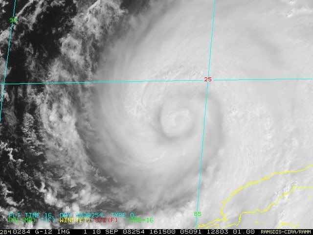
The other thing to note is convection does seem to have warmed a little bit recently.
How long these structual issues will last I'm not sure but I suspect we are looking at 12hrs at least, going to take a while to ramp up, that probably won't make much of a difference though in terms of how strong Ike can become down the road.
How long these structual issues will last I'm not sure but I suspect we are looking at 12hrs at least, going to take a while to ramp up, that probably won't make much of a difference though in terms of how strong Ike can become down the road.
0 likes
-
Ed Mahmoud
Re: Re:
deltadog03 wrote:dwg71 wrote:http://www.atmos.washington.edu/~ovens/loops/wxloop.cgi?wv_east_enhanced+12
I dont know what to make of this loop, it appears overall structure is not doing so well at the end and I cant find a center to save my arse..
It appears whole system is drifting NE, not possible is it??
I can agree with that...drifting\3 mph north or so....the whole system looks that way...not just something rotating with in something.
Just between you and me, unofficially, honest opinion, off the record, this can still completely miss Texas, and landfall in Western or Central Louisiana, no?
0 likes
http://www.atmos.washington.edu/~ovens/ ... nhanced+12
Im sure it wont last, though I hope, but it looks like crap right about now compared to 4 hours ago. No recon, but pressure has surely risen. Maybe pressure adjusted to match winds, instead of the opposite.
Just amateur speculation. I would estimate its no more than a 70Kt storm in its current state, and that might be generous.
0 likes
Who is online
Users browsing this forum: No registered users and 19 guests