BEGIN
NHC_ATCF
invest_al942009.invest
FSTDA
R
U
040
010
0000
200908271249
NONE
NOTIFY=ATRP
END
INVEST, AL, L, , , , , 94, 2009, DB, O, 2009082712, 9999999999, , , , , , METWATCH, , AL942009
AL, 94, 2009082612, , BEST, 0, 114N, 195W, 20, 1009, DB, 0, , 0, 0, 0, 0,
AL, 94, 2009082618, , BEST, 0, 111N, 210W, 20, 1009, DB, 0, , 0, 0, 0, 0,
AL, 94, 2009082700, , BEST, 0, 109N, 226W, 25, 1009, DB, 0, , 0, 0, 0, 0,
AL, 94, 2009082706, , BEST, 0, 107N, 241W, 20, 1009, DB, 0, , 0, 0, 0, 0,
AL, 94, 2009082712, , BEST, 0, 105N, 256W, 25, 1009, DB
ATL : TROPICAL DEPRESSION ERIKA (06L)
Moderator: S2k Moderators
-
cycloneye

- Admin

- Posts: 149210
- Age: 69
- Joined: Thu Oct 10, 2002 10:54 am
- Location: San Juan, Puerto Rico
ATL : TROPICAL DEPRESSION ERIKA - Computer Models
All model runs here.
818
WHXX01 KWBC 271253
CHGHUR
TROPICAL CYCLONE GUIDANCE MESSAGE
NWS TPC/NATIONAL HURRICANE CENTER MIAMI FL
1253 UTC THU AUG 27 2009
DISCLAIMER...NUMERICAL MODELS ARE SUBJECT TO LARGE ERRORS.
PLEASE REFER TO NHC OFFICIAL FORECASTS FOR TROPICAL CYCLONE
AND SUBTROPICAL CYCLONE INFORMATION.
ATLANTIC OBJECTIVE AIDS FOR
DISTURBANCE INVEST (AL942009) 20090827 1200 UTC
...00 HRS... ...12 HRS... ...24 HRS. .. ...36 HRS...
090827 1200 090828 0000 090828 1200 090829 0000
LAT LON LAT LON LAT LON LAT LON
BAMS 10.5N 25.6W 11.3N 28.3W 12.1N 31.2W 12.9N 34.4W
BAMD 10.5N 25.6W 10.7N 28.1W 11.0N 30.6W 11.4N 33.0W
BAMM 10.5N 25.6W 11.0N 28.4W 11.3N 31.3W 11.6N 34.1W
LBAR 10.5N 25.6W 10.8N 28.6W 11.4N 31.9W 12.0N 35.4W
SHIP 25KTS 29KTS 36KTS 47KTS
DSHP 25KTS 29KTS 36KTS 47KTS
...48 HRS... ...72 HRS... ...96 HRS. .. ..120 HRS...
090829 1200 090830 1200 090831 1200 090901 1200
LAT LON LAT LON LAT LON LAT LON
BAMS 13.3N 37.9W 13.4N 45.6W 13.3N 52.5W 13.4N 58.2W
BAMD 12.0N 35.3W 13.1N 39.0W 13.8N 41.8W 15.1N 44.1W
BAMM 12.0N 36.7W 12.8N 41.6W 12.9N 45.6W 12.7N 48.2W
LBAR 12.5N 38.9W 13.6N 45.3W 13.2N 44.6W 13.7N 46.3W
SHIP 58KTS 74KTS 76KTS 81KTS
DSHP 58KTS 74KTS 76KTS 81KTS
...INITIAL CONDITIONS...
LATCUR = 10.5N LONCUR = 25.6W DIRCUR = 270DEG SPDCUR = 15KT
LATM12 = 10.9N LONM12 = 22.6W DIRM12 = 263DEG SPDM12 = 15KT
LATM24 = 11.4N LONM24 = 19.5W
WNDCUR = 25KT RMAXWD = 0NM WNDM12 = 25KT
CENPRS = 1009MB OUTPRS = 1011MB OUTRAD = 200NM SDEPTH = D
0 likes
-
dolebot_Broward_NW
- Category 2

- Posts: 529
- Joined: Fri Sep 10, 2004 6:38 am


-
otowntiger
- Category 5

- Posts: 1932
- Joined: Tue Aug 31, 2004 7:06 pm
Re: ATL : INVEST 94L - Computer Models
So are the models now starting to latch onto this thing? Have they not been too bullish on it so far? What are the indications of this one being a fish? I'm sorry I have to ask because I can't easily interpret the above data.cycloneye wrote:All model runs here.
818
WHXX01 KWBC 271253
CHGHUR
TROPICAL CYCLONE GUIDANCE MESSAGE
NWS TPC/NATIONAL HURRICANE CENTER MIAMI FL
1253 UTC THU AUG 27 2009
DISCLAIMER...NUMERICAL MODELS ARE SUBJECT TO LARGE ERRORS.
PLEASE REFER TO NHC OFFICIAL FORECASTS FOR TROPICAL CYCLONE
AND SUBTROPICAL CYCLONE INFORMATION.
ATLANTIC OBJECTIVE AIDS FOR
DISTURBANCE INVEST (AL942009) 20090827 1200 UTC
...00 HRS... ...12 HRS... ...24 HRS. .. ...36 HRS...
090827 1200 090828 0000 090828 1200 090829 0000
LAT LON LAT LON LAT LON LAT LON
BAMS 10.5N 25.6W 11.3N 28.3W 12.1N 31.2W 12.9N 34.4W
BAMD 10.5N 25.6W 10.7N 28.1W 11.0N 30.6W 11.4N 33.0W
BAMM 10.5N 25.6W 11.0N 28.4W 11.3N 31.3W 11.6N 34.1W
LBAR 10.5N 25.6W 10.8N 28.6W 11.4N 31.9W 12.0N 35.4W
SHIP 25KTS 29KTS 36KTS 47KTS
DSHP 25KTS 29KTS 36KTS 47KTS
...48 HRS... ...72 HRS... ...96 HRS. .. ..120 HRS...
090829 1200 090830 1200 090831 1200 090901 1200
LAT LON LAT LON LAT LON LAT LON
BAMS 13.3N 37.9W 13.4N 45.6W 13.3N 52.5W 13.4N 58.2W
BAMD 12.0N 35.3W 13.1N 39.0W 13.8N 41.8W 15.1N 44.1W
BAMM 12.0N 36.7W 12.8N 41.6W 12.9N 45.6W 12.7N 48.2W
LBAR 12.5N 38.9W 13.6N 45.3W 13.2N 44.6W 13.7N 46.3W
SHIP 58KTS 74KTS 76KTS 81KTS
DSHP 58KTS 74KTS 76KTS 81KTS
...INITIAL CONDITIONS...
LATCUR = 10.5N LONCUR = 25.6W DIRCUR = 270DEG SPDCUR = 15KT
LATM12 = 10.9N LONM12 = 22.6W DIRM12 = 263DEG SPDM12 = 15KT
LATM24 = 11.4N LONM24 = 19.5W
WNDCUR = 25KT RMAXWD = 0NM WNDM12 = 25KT
CENPRS = 1009MB OUTPRS = 1011MB OUTRAD = 200NM SDEPTH = D
0 likes
-
cycloneye
- Admin
- Posts: 149210
- Age: 69
- Joined: Thu Oct 10, 2002 10:54 am
- Location: San Juan, Puerto Rico
Re: ATL : INVEST 94L - Computer Models
So are the models now starting to latch onto this thing? Have they not been too bullish on it so far? What are the indications of this one being a fish? I'm sorry I have to ask because I can't easily interpret the above data.
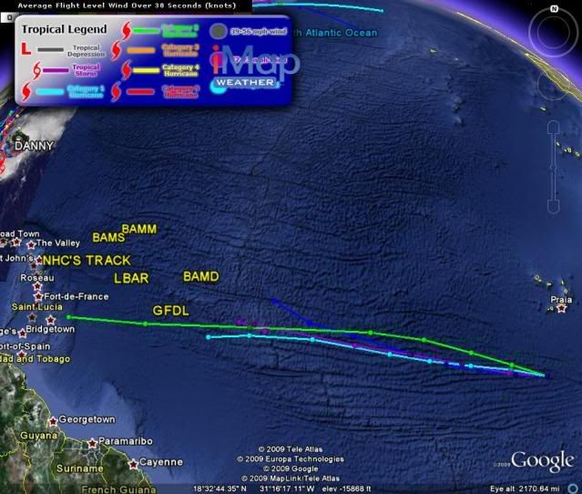
Models suggest an approach to Lesser Antilles.See graphic that HURAKAN posted above your post.Also the models intensify to hurricane.
0 likes
-
otowntiger
- Category 5
- Posts: 1932
- Joined: Tue Aug 31, 2004 7:06 pm
Re: ATL : INVEST 94L - Computer Models
Thanks Cycloneye. I didn't see that graphic until after I posted.cycloneye wrote:So are the models now starting to latch onto this thing? Have they not been too bullish on it so far? What are the indications of this one being a fish? I'm sorry I have to ask because I can't easily interpret the above data.
Models suggest an approach to Lesser Antilles.See graphic that HURAKAN posted above your post.Also the models intensify to hurricane.
0 likes
-
HurricaneMaster_PR

- Category 2
- Posts: 795
- Joined: Tue Jul 22, 2003 6:23 pm
- Location: San Juan, Puerto Rico

-
otowntiger
- Category 5
- Posts: 1932
- Joined: Tue Aug 31, 2004 7:06 pm
Re: ATL : INVEST 94L - Computer Models
HurricaneMaster_PR wrote:
Hmmm. According that this chart 50% of the models shown (2 of 4) are hinting at recurvature. I think that's pretty indicative of what may become of this one. The one interesting thing is it's current heading of wsw. That is going to work in favor of the argument that this thing becomes a player. I am now more interested to see what happens with this one.
Edit: 8/27/09 : 5:45pm Well, well, well. Now all but one goofy models takes ole 94L fishing! (Thats 5 out of 6!)
Last edited by otowntiger on Thu Aug 27, 2009 4:41 pm, edited 2 times in total.
0 likes
-
cycloneye
- Admin
- Posts: 149210
- Age: 69
- Joined: Thu Oct 10, 2002 10:54 am
- Location: San Juan, Puerto Rico
Re: ATL : INVEST 94L
In case some members missed the 8 AM Tropical Weather Outlook,here it is.
TROPICAL WEATHER OUTLOOK
NWS TPC/NATIONAL HURRICANE CENTER MIAMI FL
800 AM EDT THU AUG 27 2009
FOR THE NORTH ATLANTIC...CARIBBEAN SEA AND THE GULF OF MEXICO...
THE NATIONAL HURRICANE CENTER IS ISSUING ADVISORIES ON TROPICAL
STORM DANNY...LOCATED ABOUT 575 MILES SOUTH-SOUTHEAST OF CAPE
HATTERAS NORTH CAROLINA.
A TROPICAL WAVE IS LOCATED OVER THE FAR EASTERN ATLANTIC OCEAN ABOUT
300 MILES SOUTH-SOUTHWEST OF THE CAPE VERDE ISLANDS. THE ASSOCIATED
SHOWER ACTIVITY HAS BECOME A LITTLE BETTER ORGANIZED THIS
MORNING...AND ADDITIONAL SLOW DEVELOPMENT OF THIS SYSTEM IS
POSSIBLE OVER THE NEXT COUPLE OF DAYS AS IT MOVES WESTWARD AT 10 TO
15 MPH. THERE IS A LOW CHANCE...LESS THAN 30 PERCENT...OF THIS
SYSTEM BECOMING A TROPICAL CYCLONE DURING THE NEXT 48 HOURS.
0 likes
-
Ivanhater

- Storm2k Moderator

- Posts: 11221
- Age: 39
- Joined: Fri Jul 01, 2005 8:25 am
- Location: Pensacola
Re: ATL : INVEST 94L - Computer Models
otowntiger wrote:HurricaneMaster_PR wrote:
Hmmm. According that this chart 50% of the models shown (2 of 4) are hinting at recurvature. I think that's pretty indicative of what may become of this one. The one interesting thing is it's current heading of wsw. That is going to work in favor of the argument that this thing becomes a player. I am now more interested to see what happens with this one.
The orange one is the Clipper, which is a climo model, not a dynamical model. Like I said yesterday, the global models are showing a ridge building on top of this.
0 likes
-
Dean4Storms
- S2K Supporter

- Posts: 6358
- Age: 63
- Joined: Sun Aug 31, 2003 1:01 pm
- Location: Miramar Bch. FL
-
Blown Away

- S2K Supporter
- Posts: 10253
- Joined: Wed May 26, 2004 6:17 am
Re: ATL : INVEST 94L - Computer Models
I see the deep Bam recurving, makes sense to me. If 94L deepens quickly, like before 50W, it's more likely to recurve sooner if it stays somewhat shallow it goes more W.
0 likes
-
cycloneye
- Admin
- Posts: 149210
- Age: 69
- Joined: Thu Oct 10, 2002 10:54 am
- Location: San Juan, Puerto Rico
Re: ATL : INVEST 94L - Computer Models
According to SHIP run,shear will be favorable along the period.
Code: Select all
              *   ATLANTIC SHIPS INTENSITY FORECAST       *
                    *      GOES DATA AVAILABLE                  *
                    *      OHC  DATA AVAILABLE                  *
                    *  INVEST      AL942009  08/27/09  12 UTC   *

TIME (HR)          0     6    12    18    24    36    48    60    72    84    96   108   120


SHEAR (KT)         7     8    11    13    10     7     5     6     2    12    11    10     6
0 likes
-
Bocadude85

- Category 5
- Posts: 2991
- Age: 39
- Joined: Mon Apr 18, 2005 2:20 pm
- Location: Honolulu,Hi
Re: ATL : INVEST 94L - Computer Models
otowntiger wrote:HurricaneMaster_PR wrote:
Hmmm. According that this chart 50% of the models shown (2 of 4) are hinting at recurvature. I think that's pretty indicative of what may become of this one. The one interesting thing is it's current heading of wsw. That is going to work in favor of the argument that this thing becomes a player. I am now more interested to see what happens with this one.
The two models that show this curving to the north are the CLP5 and the BAMD.The CLP5 is a climo model and the BAMD is used for stronger systems. So currently we are looking at a track towards the West.
0 likes
-
Dean4Storms
- S2K Supporter
- Posts: 6358
- Age: 63
- Joined: Sun Aug 31, 2003 1:01 pm
- Location: Miramar Bch. FL
-
Ivanhater
- Storm2k Moderator
- Posts: 11221
- Age: 39
- Joined: Fri Jul 01, 2005 8:25 am
- Location: Pensacola
Re:
Dean4Storms wrote:I believe of all the Invests of this season thus far that this one stands the best chance at this point of being the biggest threat to the Carib. and eventually the USA!
Looks like a pattern change coming up Dean
0 likes
Re: ATL : INVEST 94L
Why would this storm be the biggest threat to the Carib and USA? I would think the same trough that has been saving us would be in effect with this if it got there right?
0 likes
-
somethingfunny

- ChatStaff

- Posts: 3926
- Age: 37
- Joined: Thu May 31, 2007 10:30 pm
- Location: McKinney, Texas
Re: ATL : INVEST 94L - Computer Models
Dean4Storms wrote:I noticed the CMC is pretty much in the same camp as these models, holding the ridge and driving it toward the Islands.
CMC has been quite consistent and bullish with 94L for the past several days.
cycloneye wrote:According to SHIP run,shear will be favorable along the period.Code: Select all
              *   ATLANTIC SHIPS INTENSITY FORECAST       *
                    *      GOES DATA AVAILABLE                  *
                    *      OHC  DATA AVAILABLE                  *
                    *  INVEST      AL942009  08/27/09  12 UTC   *

TIME (HR)          0     6    12    18    24    36    48    60    72    84    96   108   120


SHEAR (KT)         7     8    11    13    10     7     5     6     2    12    11    10     6
Don't get me started on how reliable the SHIPS shear model has been lately.
My prediction? This thread will eventually have more pages than Danny's. I'll be staying tuned in.
0 likes
Who is online
Users browsing this forum: No registered users and 47 guests