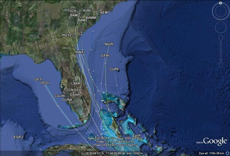
ATL: IRENE - Models

Moderator: S2k Moderators

Message
Author
Aric Dunn
Category 5
Category 5
Posts: 21228
Age: 41
Joined: Sun Sep 19, 2004 9:58 pm
Location: Ready for the Chase.
Contact:

Re: ATL: IRENE - Models

#2261 Postby Aric Dunn » Sun Aug 21, 2011 8:44 am

Kory wrote:
Aric Dunn wrote:
hurricanedude wrote:Hey Aric you dont think the Carolinas are at play?


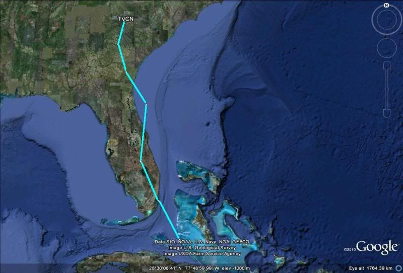
not as of right now. nothing to turn it NNE. but it could change.

What do you think about a turn just to the east of Florida and due north into SC? I certainly think that's plausible.


personally I think the models are overdoing the how fast she moves north/ nnw into the weakness. the steering seems awfully weak and a more gradual turn seem more likely if it goes north of hispaniola if it across it than it will be weaker and should be more west with a gradual turn.. right now I dont see a gulf system unless it crosses the state. just have to wait and see when this organizational phase stops and the west motion starts that will make the big difference.
0 likes   
Note: If I make a post that is brief. Please refer back to previous posts for the analysis or reasoning. I do not re-write/qoute what my initial post said each time.
If there is nothing before... then just ask :)

Space & Atmospheric Physicist, Embry-Riddle Aeronautical University,
I believe the sky is falling...

User avatar
northjaxpro
S2K Supporter
S2K Supporter
Posts: 8900
Joined: Mon Sep 27, 2010 11:21 am
Location: Jacksonville, FL

Re:

#2262 Postby northjaxpro » Sun Aug 21, 2011 8:49 am

Aric Dunn wrote:The best solution so far and has been the most consistent is the euro. it turns irene NNW into the weakness but no recurve out to sea or the carolina because there is no digging trough just the weakness and the ridge to the east and west.


I agree. The trough I feel would have to sharply amplify for Irene to reach or significantly impact the North Carolina coast or recurve move out to sea. I think the S.C. coast may see some impacts much more than N.C. at this time. Of course, the situation could change, but as of now, the curent model runs does indicate a significant weakness over the SE U.S. to have Irene move into it, but I see the system more on a Northward heading mostly for now. If ridging builds in late in the period, it may be more of a N/NW motion moving the system or possible remnants inland into the SE U.S. by late into the weekend. That is why all interests in the entire SE U.S. should be paying extremely close attention to Irene's progress because due to its massive size, it could be a potential huge rainmaker across the region.
0 likes   
NEVER, EVER SAY NEVER in the tropics and weather in general, and most importantly, with life itself!!

________________________________________________________________________________________

Fay 2008 Beryl 2012 Debby 2012 Colin 2016 Hermine 2016 Julia 2016 Matthew 2016 Irma 2017 Dorian 2019

User avatar
TreasureIslandFLGal
S2K Supporter
S2K Supporter
Posts: 1558
Age: 56
Joined: Sun Aug 15, 2004 6:16 pm
Location: Clearwater, Florida ~3 miles from the coast now. We finally moved safely off the barrier island!

#2263 Postby TreasureIslandFLGal » Sun Aug 21, 2011 8:52 am

Unfortunately it looks like we'll probably have to wait until Tuesday to have a clear indication of landfall. Many factors still left to develop. From GA to Central Panhandle IMO are greatest threat. Biggest factors:
1) Hispanola - how the storm traverses it (or not) and its state after that fact. If it greatly weakens, then a more westward direction and slower/meandering around ridge periphery. If less affected, then a more northerly path and sharper turn around the ridge periphery into the weakness.
2) Strength of ridge and speed at which it builds back to the west. IF it builds back stronger/faster then the storm will take a more westerly path through FL or EGOM. If it is slow to build back, then the weakness could be felt and periphery followed to the north sooner, resulting in the more easterly path across or to the east of Florida.
0 likes   
Chrissy & Ligeia
Chrissy & Nikki
:flag:

CrazyC83
Professional-Met
Professional-Met
Posts: 33393
Joined: Tue Mar 07, 2006 11:57 pm
Location: Deep South, for the first time!

#2264 Postby CrazyC83 » Sun Aug 21, 2011 8:53 am

If this passes north of the big islands, could it recurve without hitting the CONUS?
0 likes   

User avatar
Vortex
S2K Supporter
S2K Supporter
Posts: 4644
Age: 52
Joined: Fri Aug 01, 2003 9:34 pm
Location: Hilton Head, SC

Re:

#2265 Postby Vortex » Sun Aug 21, 2011 8:58 am

NDG wrote:A closer look at the 12z early tropical models:

They are starting to gather on the east coast of FL or just offshore. One negative thing to this that it will spend more time over water and gather more strength before entually moving onshore whether is in central or NE FL or points north towards GA or the Carolinas.

Image

The 12z TVCN just barely moved to the right, it has moved from landfall near Homestead to Miami Beach from its previous run, so I expect the NHC to not move much its track on their next advisory.

Image


12Z TCVN continues to suggest more and more like Irene will make landfall nearm Miami then head inland and up much of the FL east coast....
0 likes   

User avatar
NDG
S2K Supporter
S2K Supporter
Posts: 14933
Joined: Sun Jul 09, 2006 10:14 pm
Location: Orlando, FL

Re:

#2266 Postby NDG » Sun Aug 21, 2011 8:59 am

CrazyC83 wrote:If this passes north of the big islands, could it recurve without hitting the CONUS?


There's a big Atlantic ridge that will be nearing Bermuda by the middle of the week, she cannot recurve out to sea.
0 likes   

Kory
Tropical Storm
Tropical Storm
Posts: 200
Age: 28
Joined: Tue Aug 02, 2011 11:32 am
Location: New Orleans, Louisiana

Re:

#2267 Postby Kory » Sun Aug 21, 2011 9:00 am

CrazyC83 wrote:If this passes north of the big islands, could it recurve without hitting the CONUS?

It will definitely go more to the east of the NHC track if that does happen, but a recurve is not likely. Ridge over the Atlantic prevents it from recurving. It would go more north into SC or NC.


The posts in this forum are NOT official forecast and should not be used as such. They are just the opinion of the poster and may or may not be backed by sound meteorological data. They are NOT endorsed by any professional institution or storm2k.org. For official information, please refer to the NHC and NWS products.
0 likes   

lonelymike
S2K Supporter
S2K Supporter
Posts: 634
Joined: Sat Jul 26, 2008 10:12 am
Location: walton county fla

Re: ATL: IRENE - Models

#2268 Postby lonelymike » Sun Aug 21, 2011 9:02 am

Ivanhater wrote:Just FYI...looking over the guidance tonight there is an increasing chance this misses Florida to the east putting South Florida on the weaker side and hitting Georgia or the Carolinas


Just wanted to give a shout out to Michael :D He stayed practically 24 hours straight to provide the models and commentary on this thread. I don't always agree with Michael on models but I appreciate his effort and time. Give em a shout out :sun:
0 likes   


GO SEMINOLES

User avatar
northjaxpro
S2K Supporter
S2K Supporter
Posts: 8900
Joined: Mon Sep 27, 2010 11:21 am
Location: Jacksonville, FL

Re: Re:

#2269 Postby northjaxpro » Sun Aug 21, 2011 9:03 am

Vortex wrote:
NDG wrote:A closer look at the 12z early tropical models:

They are starting to gather on the east coast of FL or just offshore. One negative thing to this that it will spend more time over water and gather more strength before entually moving onshore whether is in central or NE FL or points north towards GA or the Carolinas.

Image

The 12z TVCN just barely moved to the right, it has moved from landfall near Homestead to Miami Beach from its previous run, so I expect the NHC to not move much its track on their next advisory.

Image


The TCVN could shift slightly left over the next couple of days, but yeah it is looking very likely now that much of the peninsula is going to get impacted for sure.
0 likes   
NEVER, EVER SAY NEVER in the tropics and weather in general, and most importantly, with life itself!!

________________________________________________________________________________________

Fay 2008 Beryl 2012 Debby 2012 Colin 2016 Hermine 2016 Julia 2016 Matthew 2016 Irma 2017 Dorian 2019

User avatar
UpTheCreek
Category 1
Category 1
Posts: 397
Age: 60
Joined: Tue Aug 31, 2004 5:28 pm
Location: Vassalboro, Maine

Re: ATL: IRENE - Models

#2270 Postby UpTheCreek » Sun Aug 21, 2011 9:05 am

lonelymike wrote:
Ivanhater wrote:Just FYI...looking over the guidance tonight there is an increasing chance this misses Florida to the east putting South Florida on the weaker side and hitting Georgia or the Carolinas


Just wanted to give a shout out to Michael :D He stayed practically 24 hours straight to provide the models and commentary on this thread. I don't always agree with Michael on models but I appreciate his effort and time. Give em a shout out :sun:


+1...... I ALWAYS appreciate Ivanhater's work and opinions!
0 likes   

WilmingtonSandbar
S2K Supporter
S2K Supporter
Posts: 503
Joined: Sun Aug 29, 2010 12:11 pm
Location: Southport, NC

Re: Re:

#2271 Postby WilmingtonSandbar » Sun Aug 21, 2011 9:07 am

GTStorm wrote:
Dean4Storms wrote:Sure looks like the development sooner and further north in latitude made all the difference in the world with the models having Irene feel the weakness and turn more sharply into it.

I believe though this scenario could change if Irene fails to deepen much more due to either the dry air or hitting Hispaniola directly. If she were to be weakened or remains weak she could make a less dramatic NW turn and still end up in the SE GOM!


This is reminding me a lot of Floyd in 1999, without the CAT 5 factored in. Track trending and forecasting is very similar, though.

I'd be real concerned if I lived in Wilmington NC (AKA "the Chin") right now.


Trust me, we are watching and are concerned.
0 likes   
Diana X2 (look it up), Bertha, Fran, Bonnie, Floyd, Dennis, Charley, Ophelia, Ernesto, Irene, Matthew, And Florence

User avatar
Duddy
Category 1
Category 1
Posts: 363
Joined: Sat Jun 10, 2006 9:07 pm
Location: Wilmington, NC

Re: Re:

#2272 Postby Duddy » Sun Aug 21, 2011 9:15 am

WilmingtonSandbar wrote:
GTStorm wrote:
Dean4Storms wrote:Sure looks like the development sooner and further north in latitude made all the difference in the world with the models having Irene feel the weakness and turn more sharply into it.

I believe though this scenario could change if Irene fails to deepen much more due to either the dry air or hitting Hispaniola directly. If she were to be weakened or remains weak she could make a less dramatic NW turn and still end up in the SE GOM!


This is reminding me a lot of Floyd in 1999, without the CAT 5 factored in. Track trending and forecasting is very similar, though.

I'd be real concerned if I lived in Wilmington NC (AKA "the Chin") right now.


Trust me, we are watching and are concerned.


Agreed.
0 likes   

User avatar
ROCK
Category 5
Category 5
Posts: 9254
Age: 53
Joined: Tue Aug 17, 2004 7:30 am
Location: Kemah, Texas

Re: ATL: IRENE - Models

#2273 Postby ROCK » Sun Aug 21, 2011 9:16 am

lonelymike wrote:
Ivanhater wrote:Just FYI...looking over the guidance tonight there is an increasing chance this misses Florida to the east putting South Florida on the weaker side and hitting Georgia or the Carolinas


Just wanted to give a shout out to Michael :D He stayed practically 24 hours straight to provide the models and commentary on this thread. I don't always agree with Michael on models but I appreciate his effort and time. Give em a shout out :sun:


great job IVAN...as always,,,,and i think your statement is looking more a possibility as a center relo to the north and now its looking to track over PR.....might miss FL all together now...
0 likes   

User avatar
Typhoon_Willie
Category 5
Category 5
Posts: 1042
Joined: Mon Jun 09, 2003 3:19 pm
Location: Greenacres City, Florida

Re: ATL: IRENE - Models

#2274 Postby Typhoon_Willie » Sun Aug 21, 2011 9:24 am

Looks like the latest 5 day cone still suggests the possibility of a South Florida landfall guys.
0 likes   

User avatar
Bocadude85
Category 5
Category 5
Posts: 2941
Age: 37
Joined: Mon Apr 18, 2005 2:20 pm
Location: Honolulu,Hi

Re: ATL: IRENE - Models

#2275 Postby Bocadude85 » Sun Aug 21, 2011 9:27 am

I wouldnt be surprised to see this miss Fla to the east now that the center has relocated farther north
0 likes   

User avatar
Weatherboy1
Category 5
Category 5
Posts: 1167
Age: 48
Joined: Mon Jul 05, 2004 1:50 pm
Location: Jupiter, FL

#2276 Postby Weatherboy1 » Sun Aug 21, 2011 9:29 am

Wow -- this looks like a pretty solid consensus that we're in for something here in south FL. And the possibility for serious intensification exists if Irene doesn't do battle with the island of Hispanola. Ugh
0 likes   

User avatar
northtxboy
Category 1
Category 1
Posts: 262
Age: 42
Joined: Mon Jan 03, 2011 1:50 pm
Location: Windom Tx
Contact:

#2277 Postby northtxboy » Sun Aug 21, 2011 9:33 am

Poeple in Florida and east gulf dont let ur guard down. wxman57 said yesterday that it would track just west off florida and I have to agree with him. most of the time to man is right on the money, its what he does for a living. Just because the models shifted to the east for 1 or 2 runs doesnt mean anything this far out. Everyone should be prepared!!!
0 likes   

HugoCameandLeft
Tropical Low
Tropical Low
Posts: 45
Joined: Mon Aug 30, 2004 6:42 am
Location: Charleston, SC

#2278 Postby HugoCameandLeft » Sun Aug 21, 2011 9:34 am

In Charleston and paying attention. Generally speaking, if it were to skirt the FL coast and ride up into the Carolinas, how much impact would that have on intensity and/or intensification?

EDIT - Sorry mods, should have posted this in discussion forum. Pls feel free to move if you like.
Last edited by HugoCameandLeft on Sun Aug 21, 2011 9:41 am, edited 1 time in total.
0 likes   

bella_may
Category 3
Category 3
Posts: 881
Joined: Wed Dec 22, 2010 2:13 pm
Location: SE Mississippi coast

Re:

#2279 Postby bella_may » Sun Aug 21, 2011 9:36 am

northtxboy wrote:Poeple in Florida and east gulf dont let ur guard down. wxman57 said yesterday that it would track just west off florida and I have to agree with him. most of the time to man is right on the money, its what he does for a living. Just because the models shifted to the east for 1 or 2 runs doesnt mean anything this far out. Everyone should be prepared!!!

Exactly what I said last night. And if this gets in the e gom. No telling where it could go from there
0 likes   

User avatar
M_0331
S2K Supporter
S2K Supporter
Posts: 137
Joined: Fri Sep 10, 2004 12:05 pm
Location: SE COAST, SC

Re: ATL: IRENE - Models

#2280 Postby M_0331 » Sun Aug 21, 2011 9:48 am

A long ways out but looks like a Floyd w/o NNE turn. I am glad I cut my timber last yr.
0 likes   


Return to “2011”

Who is online

Users browsing this forum: No registered users and 59 guests