000
WTNT33 KNHC 212345
TCPAT3
BULLETIN
Tropical Storm Cindy Intermediate Advisory Number 9A
NWS National Hurricane Center Miami FL AL032017
700 PM CDT Wed Jun 21 2017
...HEAVY RAINFALL CONTINUES TO AFFECT THE NORTHERN GULF COAST...
...THESE RAINS COULD PRODUCE LIFE-THREATENING FLASH FLOODING...
SUMMARY OF 700 PM CDT...0000 UTC...INFORMATION
----------------------------------------------
LOCATION...28.3N 93.3W
ABOUT 125 MI...200 KM S OF LAKE CHARLES LOUISIANA
ABOUT 115 MI...185 KM SE OF GALVESTON TEXAS
MAXIMUM SUSTAINED WINDS...50 MPH...85 KM/H
PRESENT MOVEMENT...NW OR 315 DEGREES AT 8 MPH...13 KM/H
MINIMUM CENTRAL PRESSURE...992 MB...29.29 INCHES
WATCHES AND WARNINGS
--------------------
CHANGES WITH THIS ADVISORY:
None.
SUMMARY OF WATCHES AND WARNINGS IN EFFECT:
A Tropical Storm Warning is in effect for...
* San Luis Pass Texas to the mouth of the Mississippi River
A Tropical Storm Warning means that tropical storm conditions are
expected somewhere within the warning area, in this case within the
next 12 to 24 hours.
Interests elsewhere along the U.S. Gulf Coast from the central Texas
coast to the western Florida Panhandle should monitor the progress
of this system.
For storm information specific to your area, including possible
inland watches and warnings, please monitor products issued by your
local National Weather Service forecast office.
DISCUSSION AND 48-HOUR OUTLOOK
------------------------------
At 700 PM CDT (0000 UTC), the center of Tropical Storm Cindy was
located near latitude 28.3 North, longitude 93.3 West. Cindy is
moving toward the northwest near 8 mph (13 km/h). A turn toward the
north-northwest is expected tonight and Thursday, with a turn toward
the northeast expected on Friday. On the forecast track, the center
of Cindy will move inland over southeastern Texas or southwestern
Louisiana early Thursday, then move near or over extreme eastern
Texas, western and northern Louisiana, and southeastern Arkansas
Thursday and Thursday night.
Maximum sustained winds are near 50 mph (85 km/h) with higher
gusts. Little change in strength is expected before landfall, with
weakening expected thereafter. An elevated oil platform located
southwest of the center recently reported a wind gust of 75 mph.
Tropical-storm-force winds extend outward up to 115 miles (185 km)
from the center.
The estimated minimum central pressure based on recent observations
from oil rigs near the center is 992 mb (29.29 inches).
HAZARDS AFFECTING LAND
----------------------
RAINFALL: Cindy is expected to produce total rain accumulations of
6 to 9 inches with isolated maximum amounts up to 15 inches over
southeastern Louisiana, southern Mississippi, southern Alabama, and
western portions of the Florida Panhandle through Thursday night.
This rainfall could cause life-threatening flash flooding in these
areas.
Rainfall amounts of 3 to 5 inches with isolated maximum amounts of
7 inches can be expected farther west across western Louisiana and
eastern Texas through Thursday night. Rainfall should spread
northeastward across Arkansas and into portions of the Tennessee
and Ohio Valleys through Friday, with total rain accumulations of
3 to 5 inches with locally higher amounts possible.
WIND: Tropical storm conditions should spread westward and
northward through the Tropical Storm Warning area this evening
through Thursday.
STORM SURGE: Inundation of 1 to 3 feet above ground level is
expected along the coast in portions of the Tropical Storm Warning
area. Inundation of 1 to 3 feet above ground level is also possible
elsewhere along the coast from southeastern Louisiana to the western
Florida Panhandle in areas of strong onshore winds.
TORNADOES: A few tornadoes are possible tonight from the far
western Florida Panhandle across southwestern Alabama, southern
Mississippi, and southern Louisiana.
NEXT ADVISORY
-------------
Next complete advisory at 1000 PM CDT.
$$
Forecaster Stewart
ATL: CINDY - Post-Tropical - Discussion
Moderator: S2k Moderators
-
southerngale

- Retired Staff

- Posts: 27420
- Joined: Thu Oct 10, 2002 1:27 am
- Location: Southeast Texas (Beaumont area)
Re: ATL: CINDY - Tropical Storm - Discussion
0 likes
Please support Storm2k by making a donation today. It is greatly appreciated! Click here: 
 my Cowboys my Rockets my Astros
my Cowboys my Rockets my Astros-
HurricaneBrain

- S2K Supporter

- Posts: 430
- Joined: Thu Jun 30, 2011 2:07 pm
- Location: Beaumont, TX
Re: ATL: CINDY - Recon
Looks like RECON is delayed as weather in Biloxi is affecting takeoff.
0 likes
-
southerngale
- Retired Staff
- Posts: 27420
- Joined: Thu Oct 10, 2002 1:27 am
- Location: Southeast Texas (Beaumont area)
Re: ATL: CINDY - Tropical Storm - Discussion
sphelps8681 wrote:Here in Lumberton North of Beaumont, Tx we have light rain and no wind. Guess this is the start of a long night.
It should be coming soon. Just outside Beaumont, I'm getting a lot of rain and it's quite windy, but nothing to write home about. I'm outside on the patio and I had to get a jacket lol
2 likes
Please support Storm2k by making a donation today. It is greatly appreciated! Click here:
my Cowboys my Rockets my Astros
my Cowboys my Rockets my Astros-
sphelps8681
- Category 2

- Posts: 673
- Joined: Thu Aug 16, 2007 5:37 pm
- Location: Somewhere over the rainbow
Re: ATL: CINDY - Tropical Storm - Discussion
One of our local mets says it will make landfall at Johnsons Bayou, La. Which is about 60 mi from where I am at.
1 likes
-
sphelps8681
- Category 2
- Posts: 673
- Joined: Thu Aug 16, 2007 5:37 pm
- Location: Somewhere over the rainbow
-
southerngale
- Retired Staff
- Posts: 27420
- Joined: Thu Oct 10, 2002 1:27 am
- Location: Southeast Texas (Beaumont area)
Re: ATL: CINDY - Tropical Storm - Discussion
sphelps8681 wrote:One of our local mets says it will make landfall at Johnsons Bayou, La. Which is about 60 mi from where I am at.
It depends on when it makes the turn, but regardless, we're getting a lot of rain.
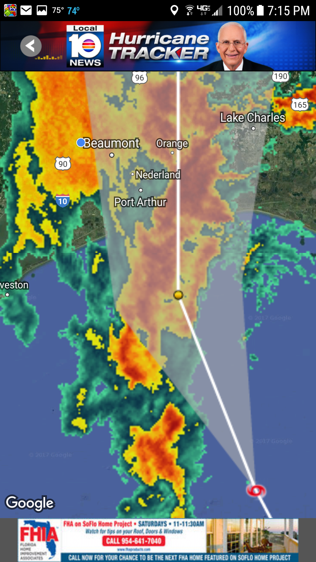
http://www.directupload.net
http://fs5.directupload.net/images/170622/bfeclni7.png
1 likes
Please support Storm2k by making a donation today. It is greatly appreciated! Click here:
my Cowboys my Rockets my Astros
my Cowboys my Rockets my Astros
Re: ATL: CINDY - Tropical Storm - Discussion
Seems to be back to one center ATM, it may wind up a little bit before landfall. I'd like to thank Texas and Mexico for all this dry air.
3 likes
The following post is NOT an official forecast and should not be used as such. It is just the opinion of the poster and may or may not be backed by sound meteorological data. It is NOT endorsed by any professional institution including storm2k.org For Official Information please refer to the NHC and NWS products.


-
sphelps8681
- Category 2
- Posts: 673
- Joined: Thu Aug 16, 2007 5:37 pm
- Location: Somewhere over the rainbow
Re: ATL: CINDY - Tropical Storm - Discussion
southerngale wrote:sphelps8681 wrote:One of our local mets says it will make landfall at Johnsons Bayou, La. Which is about 60 mi from where I am at.
It depends on when it makes the turn, but regardless, we're getting a lot of rain.
I know it is such a fine line between that location and ours.
0 likes

Re: ATL: CINDY - Tropical Storm - Discussion
sphelps8681 wrote:Here in Lumberton North of Beaumont, Tx we have light rain and no wind. Guess this is the start of a long night.
Yeah. It looks like a really strong band is about to hit your area. That's the 2+" and hour stuff. We have a couple day total of about 5" here, but we really didn't get anything with remotely that rainfall rate.
https://radar.weather.gov/ridge/radar.p ... 1&loop=yes
Also, it's beautiful here tonight. Breezy, partly cloudy and mild - we're lucky we got in that gap.
0 likes
Re: ATL: CINDY - Tropical Storm - Discussion
tailgater wrote:Seems to be back to one center ATM, it may wind up a little bit before landfall. I'd like to thank Texas and Mexico for all this dry air.
Agreed. I think it's at that time of night where tops are starting to warm. But since it's at least several hours from shore, there's always a chance of landfall during an intensifying phase. Luckily nothing catastrophic is going to come out of Cindy. But so far it's been a cool storm to track and be in.
1 likes
-
sphelps8681
- Category 2
- Posts: 673
- Joined: Thu Aug 16, 2007 5:37 pm
- Location: Somewhere over the rainbow
Re: ATL: CINDY - Tropical Storm - Discussion
Steve wrote:sphelps8681 wrote:Here in Lumberton North of Beaumont, Tx we have light rain and no wind. Guess this is the start of a long night.
Yeah. It looks like a really strong band is about to hit your area. That's the 2+" and hour stuff. We have a couple day total of about 5" here, but we really didn't get anything with remotely that rainfall rate.
https://radar.weather.gov/ridge/radar.p ... 1&loop=yes
Also, it's beautiful here tonight. Breezy, partly cloudy and mild - we're lucky we got in that gap.
I saw the same band about to happen. It's like the silence before the storm. Not a lot of anything right now.
0 likes
-
sphelps8681
- Category 2
- Posts: 673
- Joined: Thu Aug 16, 2007 5:37 pm
- Location: Somewhere over the rainbow
Re: ATL: CINDY - Tropical Storm - Discussion
Had to post this. Way to funny!!
https://scontent.xx.fbcdn.net/v/t1.0-9/ ... e=59E63AFD
No disrespect to anyone in bad situation but sometimes during those times you need to laugh a little.
https://scontent.xx.fbcdn.net/v/t1.0-9/ ... e=59E63AFD
No disrespect to anyone in bad situation but sometimes during those times you need to laugh a little.
Last edited by sphelps8681 on Wed Jun 21, 2017 8:06 pm, edited 1 time in total.
5 likes
-
Aric Dunn
- Category 5

- Posts: 21228
- Age: 41
- Joined: Sun Sep 19, 2004 9:58 pm
- Location: Ready for the Chase.
- Contact:
Re: ATL: CINDY - Tropical Storm - Discussion
definitely some eastward drifting this past few hours. .
0 likes
Note: If I make a post that is brief. Please refer back to previous posts for the analysis or reasoning. I do not re-write/qoute what my initial post said each time.
If there is nothing before... then just ask
Space & Atmospheric Physicist, Embry-Riddle Aeronautical University,
I believe the sky is falling...
If there is nothing before... then just ask
Space & Atmospheric Physicist, Embry-Riddle Aeronautical University,
I believe the sky is falling...

Re: ATL: CINDY - Tropical Storm - Discussion
Heavy band now over beaumont. Oddly theres a bunch of lightning with it. You don't usually see that with a tropical system. Pouring buckets! Winds now at a good sustained 20 or so gusting to 30 with this band. Lots more to come for us in Beaumont.
2 likes
-
sphelps8681
- Category 2
- Posts: 673
- Joined: Thu Aug 16, 2007 5:37 pm
- Location: Somewhere over the rainbow
Re: ATL: CINDY - Tropical Storm - Discussion
Rain really coming down now. Trees they ain't a blowing.
1 likes

Re: ATL: CINDY - Tropical Storm - Discussion
sphelps8681 wrote:One of our local mets says it will make landfall at Johnsons Bayou, La. Which is about 60 mi from where I am at.
This is right out my front door. I have to say that so far we've only had one heavy band of rain outside of cooler temps and a nice breeze. I'm okay with this and pray it continues.
0 likes
Re: ATL: CINDY - Tropical Storm - Discussion
sphelps8681 wrote:Had to post this. Way to funny!!
https://scontent.xx.fbcdn.net/v/t1.0-9/ ... e=59E63AFD
No disrespect to anyone in bad situation but sometimes during those times you need to laugh a little.
It is funny, but everywhere you went yesterday afternoon and even throughout the morning mowers were going. Not for Jim Cantore but so that you can see what's slithering around in flood waters.................and the fact that it won't be dry enough again for a few weeks to mow again.
1 likes
-
southerngale
- Retired Staff
- Posts: 27420
- Joined: Thu Oct 10, 2002 1:27 am
- Location: Southeast Texas (Beaumont area)
Re: ATL: CINDY - Tropical Storm - Discussion
djmikey wrote:Heavy band now over beaumont. Oddly theres a bunch of lightning with it. You don't usually see that with a tropical system. Pouring buckets! Winds now at a good sustained 20 or so gusting to 30 with this band. Lots more to come for us in Beaumont.
I've been surprised by the thunder and lightning and it's really coming down now!
I'm also surprised that I had to change out of my shorts into sweatpants and put on a jacket just to sit outside and watch it all.
1 likes
Please support Storm2k by making a donation today. It is greatly appreciated! Click here:
my Cowboys my Rockets my Astros
my Cowboys my Rockets my Astros-
sphelps8681
- Category 2
- Posts: 673
- Joined: Thu Aug 16, 2007 5:37 pm
- Location: Somewhere over the rainbow
Re: ATL: CINDY - Tropical Storm - Discussion
Last edited by sphelps8681 on Wed Jun 21, 2017 8:24 pm, edited 1 time in total.
0 likes
Who is online
Users browsing this forum: No registered users and 46 guests