EPAC: GREG - Post-Tropical

Moderator: S2k Moderators

Message
Author
User avatar
cycloneye
Admin
Admin
Posts: 139054
Age: 67
Joined: Thu Oct 10, 2002 10:54 am
Location: San Juan, Puerto Rico

Re: EPAC: GREG - Tropical Storm

#101 Postby cycloneye » Mon Jul 24, 2017 9:37 am

Tropical Storm Greg Discussion Number 29
NWS National Hurricane Center Miami FL EP072017
800 AM PDT Mon Jul 24 2017

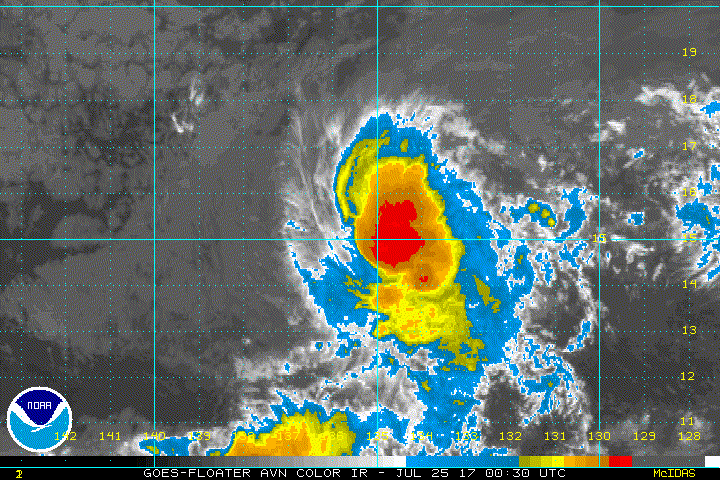
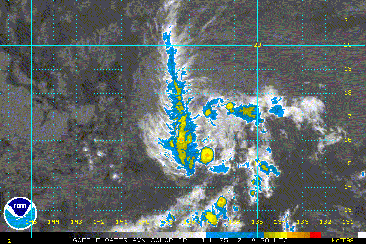
Greg's convective structure is gradually deteriorating, likely due
to very dry air in the surrounding atmosphere. However, the
initial intensity remains 40 kt on this advisory, primarily since
subjective and objective final-T numbers still range between T2.0
and T3.0. Along with the dry environment, deep-layer vertical
shear is expected to turn out of the west and increase in 36-48
hours, and Greg will be moving over marginally warm waters of
around 26 deg C. Therefore, gradual weakening is anticipated, and
Greg will likely be a tropical depression in about 48 hours and
then a remnant low by day 3. This forecast is just an update of
the previous one and is very close to the ICON intensity consensus.

Based on the latest center fixes, Greg's motion has been
oscillating between westward and west-northwestward, and the
12-hour motion estimate is 280/10 kt. A more definitive
west-northwestward motion is likely to begin soon and continue for
the next 48 hours as the ridge axis to Greg's north changes from a
north-south orientation to a more east-west orientation. After 48
hours, the remnant low of Greg should then be steered westward and
west-southwestward by the lower-level trade winds. The track
guidance envelope shifted northeastward between 12-48 hours on this
cycle, and as a result the new NHC track forecast has been adjusted
in that direction during that period. Otherwise, there are no
significant changes from the previous forecast.

FORECAST POSITIONS AND MAX WINDS

INIT 24/1500Z 14.6N 133.2W 40 KT 45 MPH
12H 25/0000Z 15.1N 134.5W 40 KT 45 MPH
24H 25/1200Z 15.9N 135.8W 35 KT 40 MPH
36H 26/0000Z 16.7N 137.2W 35 KT 40 MPH
48H 26/1200Z 17.3N 138.7W 30 KT 35 MPH
72H 27/1200Z 17.4N 142.0W 25 KT 30 MPH...POST-TROP/REMNT LOW
96H 28/1200Z 16.5N 145.0W 20 KT 25 MPH...POST-TROP/REMNT LOW
120H 29/1200Z 15.5N 147.0W 20 KT 25 MPH...POST-TROP/REMNT LOW

$$
Forecaster Berg
0 likes   
Visit the Caribbean-Central America Weather Thread where you can find at first post web cams,radars
and observations from Caribbean basin members Click Here

User avatar
cycloneye
Admin
Admin
Posts: 139054
Age: 67
Joined: Thu Oct 10, 2002 10:54 am
Location: San Juan, Puerto Rico

Re: EPAC: GREG - Tropical Storm

#102 Postby cycloneye » Mon Jul 24, 2017 3:44 pm

Tropical Storm Greg Discussion Number 30
NWS National Hurricane Center Miami FL EP072017
200 PM PDT Mon Jul 24 2017

Even embedded within a relatively dry and stable air mass, Greg's
deep convection has increased again during the day. Dvorak CI
numbers remain between 35-45 kt, and recent ASCAT data showed
maximum winds near or a little above 35 kt. Because convection has
recently increased, I see no reason to deviate from the 40 kt we've
been carrying. Despite the recent convective upswing, the
environment ahead of Greg will become less conducive over the next
day or two. The atmosphere will continue to get a little drier, and
vertical shear is expected to increase out of the south and west.
In addition, Greg will be moving toward cooler waters. All of this
means that gradual weakening is anticipated, with Greg likely to
become a tropical depression in 48 hours and a remnant low by day
3. This scenario remains close to SHIPS, HCCA, and the ICON
intensity consensus.

Greg still appears to be moving westward, or 275/10 kt, but the
models insist that the cyclone will soon turn west-northwestward or
northwestward due to weak ridging to its northwest and a low-level
trough to its northeast. After it becomes a remnant low, Greg's
shallower circulation should turn westward and then
west-southwestward in the low-level trade wind flow. The updated
NHC forecast is very similar to the previous one and remains close
to the TVCN multi-model consensus.

FORECAST POSITIONS AND MAX WINDS

INIT 24/2100Z 14.5N 134.3W 40 KT 45 MPH
12H 25/0600Z 15.1N 135.4W 35 KT 40 MPH
24H 25/1800Z 15.9N 136.8W 35 KT 40 MPH
36H 26/0600Z 16.7N 138.1W 35 KT 40 MPH
48H 26/1800Z 17.3N 139.5W 30 KT 35 MPH
72H 27/1800Z 17.1N 142.6W 25 KT 30 MPH...POST-TROP/REMNT LOW
96H 28/1800Z 16.0N 145.5W 20 KT 25 MPH...POST-TROP/REMNT LOW
120H 29/1800Z 15.0N 148.0W 20 KT 25 MPH...POST-TROP/REMNT LOW

$$
Forecaster Berg
0 likes   
Visit the Caribbean-Central America Weather Thread where you can find at first post web cams,radars
and observations from Caribbean basin members Click Here

User avatar
cycloneye
Admin
Admin
Posts: 139054
Age: 67
Joined: Thu Oct 10, 2002 10:54 am
Location: San Juan, Puerto Rico

Re: EPAC: GREG - Tropical Storm

#103 Postby cycloneye » Mon Jul 24, 2017 9:40 pm

Tropical Storm Greg Discussion Number 31
NWS National Hurricane Center Miami FL EP072017
800 PM PDT Mon Jul 24 2017

The cloud pattern of Greg has changed little during the last
several hours. The low-level center of the storm remains covered
up by an area of deep convection that has increased in intensity
during the past few hours. The latest Dvorak classifications
are largely unchanged from earlier, and the initial wind speed
estimate remains 40 kt for this advisory. This intensity estimate
is also in fairly close agreement with the earlier scatterometer
data.

Greg has made the expected turn to the west-northwest on the south
side of a low- to mid-level ridge. The models suggest that Greg
should move west-northwestward to northwestward during the
next couple of days as the ridge to the north of the system weakens
a little. A turn to the west and then west-southwest is expected in
2 to 3 days when Greg becomes a shallow system and is steered by the
low-level trade wind flow. The NHC track forecast is a tad to the
north of the previous one, trending toward the latest model
consensus aids.

The tropical storm is still over relatively warm 27 deg C waters
and in a low wind shear environment. The environment along the
projected path of Greg is expected to become hostile during
the next couple of days, with the cyclone forecast to move into a
progressively drier air mass and over waters cooler than 26 deg C
beginning in about 24 h. In addition, a significant increase in
northwesterly wind shear is expected to begin in 36 to 48 h. These
unfavorable conditions should cause a steady weakening trend, and
Greg is forecast to become a remnant low by 72 h. The NHC intensity
forecast is identical to the previous one and in line with the bulk
of the model guidance.

FORECAST POSITIONS AND MAX WINDS

INIT 25/0300Z 14.8N 134.9W 40 KT 45 MPH
12H 25/1200Z 15.4N 135.9W 35 KT 40 MPH
24H 26/0000Z 16.3N 137.3W 35 KT 40 MPH
36H 26/1200Z 17.1N 138.7W 35 KT 40 MPH
48H 27/0000Z 17.5N 140.2W 30 KT 35 MPH
72H 28/0000Z 17.0N 143.1W 25 KT 30 MPH...POST-TROP/REMNT LOW
96H 29/0000Z 16.0N 146.0W 20 KT 25 MPH...POST-TROP/REMNT LOW
120H 30/0000Z 15.0N 148.5W 20 KT 25 MPH...POST-TROP/REMNT LOW

$$
Forecaster Cangialosi
0 likes   
Visit the Caribbean-Central America Weather Thread where you can find at first post web cams,radars
and observations from Caribbean basin members Click Here

Sciencerocks
Category 5
Category 5
Posts: 7284
Age: 38
Joined: Thu Jul 06, 2017 1:51 am

Re: EPAC: GREG - Tropical Storm

#104 Postby Sciencerocks » Tue Jul 25, 2017 3:11 am

Image
0 likes   

Sciencerocks
Category 5
Category 5
Posts: 7284
Age: 38
Joined: Thu Jul 06, 2017 1:51 am

Re: EPAC: GREG - Tropical Storm

#105 Postby Sciencerocks » Tue Jul 25, 2017 4:01 am

000
WTPZ42 KNHC 250854
TCDEP2

Tropical Storm Greg Discussion Number 32
NWS National Hurricane Center Miami FL EP072017
200 AM PDT Tue Jul 25 2017

Convection associated with Greg is currently very disorganized and
confined to the northwestern quadrant. The initial intensity
remains at 40 kt based on a blend of various satellite intensity
estimates. Greg is forecast to move into a drier air mass,
encounter increasing shear, and move over decreasing sea surface
temperatures during the next 48-72 h, and this combination should
result in the system degenerating to a remnant low during this
time. The new intensity forecast is changed little from the
previous forecast except to make the cyclone a remnant low at 48 h.

The initial motion is 295/8. Greg should move northwestward for
the next day or so on the south side of a low- to mid-level ridge.
After that, a turn to the west and then west-southwest is expected
when Greg becomes a shallow system and is steered by the low-level
trade wind flow. The NHC track forecast is again a little to the
north of the previous forecast and lies a little to the south
of the various consensus models.


FORECAST POSITIONS AND MAX WINDS

INIT 25/0900Z 15.2N 135.7W 40 KT 45 MPH
12H 25/1800Z 16.0N 136.7W 35 KT 40 MPH
24H 26/0600Z 16.9N 137.9W 35 KT 40 MPH
36H 26/1800Z 17.5N 139.4W 30 KT 35 MPH
48H 27/0600Z 17.6N 140.8W 30 KT 35 MPH...POST-TROP/REMNT LOW
72H 28/0600Z 17.0N 144.0W 25 KT 30 MPH...POST-TROP/REMNT LOW
96H 29/0600Z 16.0N 146.5W 20 KT 25 MPH...POST-TROP/REMNT LOW
120H 30/0600Z 15.0N 149.5W 20 KT 25 MPH...POST-TROP/REMNT LOW

$$
Forecaster Beven


Quick Links and Add
0 likes   

Sciencerocks
Category 5
Category 5
Posts: 7284
Age: 38
Joined: Thu Jul 06, 2017 1:51 am

Re: EPAC: GREG - Tropical Depression

#106 Postby Sciencerocks » Tue Jul 25, 2017 9:02 pm

Image
0 likes   

Sciencerocks
Category 5
Category 5
Posts: 7284
Age: 38
Joined: Thu Jul 06, 2017 1:51 am

Re: EPAC: GREG - Tropical Depression

#107 Postby Sciencerocks » Tue Jul 25, 2017 10:00 pm

000
WTPZ42 KNHC 260256
TCDEP2

Tropical Depression Greg Discussion Number 35
NWS National Hurricane Center Miami FL EP072017
800 PM PDT Tue Jul 25 2017

A new burst of convection has developed over the western side of
the circulation of Greg during the past couple of hours, helping to
maintain the system as a 30-kt depression. The current convection is
expected to be relatively short lived, however, as southerly shear
should increase over the cyclone due to a sharp upper-level shear
axis located to its southwest. At the same time, the cyclone will
continue to move into a drier and more stable airmass, and over
increasingly cooler waters. Over the next 24 hours, the shear is
expected to increase even further and turn out of the northwest.
This will induce further weakening, and organized deep convection
is expected to be sheared away from the system's circulation by
Wednesday night. Therefore, the NHC forecast calls for Greg to
degenerate into a remnant low by that time, but it could occur
sooner. The remnant low is then likely to open up into a trough by
day 4 or 5.

Greg has been moving northwestward at 310/12 kt. The forecast track
reasoning remains the same as the previous forecast, as low- to
mid-level troughing north of the depression should maintain a
northwestward or west-northwestward motion for the next 24 hours or
so. After that time, the remnant low should turn westward and then
west-southwestward, embedded in the low-level trade winds forced by
surface high pressure to the north. Model guidance is tightly
clustered through 36 hours, but then begins to spread a little,
likely due to differences in the strength of the low-level ridge.
The latest NHC track is near the GFS/ECMWF consensus.

FORECAST POSITIONS AND MAX WINDS

INIT 26/0300Z 17.2N 138.8W 30 KT 35 MPH
12H 26/1200Z 17.8N 139.7W 30 KT 35 MPH
24H 27/0000Z 18.2N 141.2W 25 KT 30 MPH...POST-TROP/REMNT LOW
36H 27/1200Z 18.3N 143.0W 25 KT 30 MPH...POST-TROP/REMNT LOW
48H 28/0000Z 18.0N 144.7W 25 KT 30 MPH...POST-TROP/REMNT LOW
72H 29/0000Z 17.0N 147.6W 20 KT 25 MPH...POST-TROP/REMNT LOW
96H 30/0000Z 16.0N 150.5W 20 KT 25 MPH...POST-TROP/REMNT LOW
120H 31/0000Z...DISSIPATED

$$
Forecaster Latto/Cangialosi
0 likes   

Sciencerocks
Category 5
Category 5
Posts: 7284
Age: 38
Joined: Thu Jul 06, 2017 1:51 am

Re: EPAC: GREG - Tropical Depression

#108 Postby Sciencerocks » Wed Jul 26, 2017 2:53 am

Image
0 likes   

Sciencerocks
Category 5
Category 5
Posts: 7284
Age: 38
Joined: Thu Jul 06, 2017 1:51 am

Re: EPAC: GREG - Tropical Depression

#109 Postby Sciencerocks » Wed Jul 26, 2017 3:52 am

ZCZC MIATCDEP2 ALL
TTAA00 KNHC DDHHMM

Tropical Depression Greg Discussion Number 36
NWS National Hurricane Center Miami FL EP072017
200 AM PDT Wed Jul 26 2017

Even with the help of microwave imagery, the center of Greg is
difficult to locate due to the disorganization of the associated
convection. The best estimate is that the center is to the
southeast of the remaining convection. The initial intensity
remains 30 kt for this advisory, which could be generous. A
combination of continued southerly to westerly shear, a dry air
mass, and cool sea surface temperatures along the forecast track
should cause the cyclone to stop producing convection and degenerate
to a remnant low in about 24 h. The low is subsequently expected
to weaken to a trough in 72-96 h.

The initial motion is 305/12. Low- to mid-level troughing north of
the depression should maintain a northwestward or west-northwestward
motion for the next 12-24 hours. After that, the remnant low
should turn west-southwestward in the trade winds. The forecast
track lies near the model consensus and is similar to the previous
advisory.


FORECAST POSITIONS AND MAX WINDS

INIT 26/0900Z 17.8N 139.5W 30 KT 35 MPH
12H 26/1800Z 18.2N 140.6W 30 KT 35 MPH
24H 27/0600Z 18.4N 142.3W 25 KT 30 MPH...POST-TROP/REMNT LOW
36H 27/1800Z 18.3N 144.0W 25 KT 30 MPH...POST-TROP/REMNT LOW
48H 28/0600Z 17.9N 145.6W 20 KT 25 MPH...POST-TROP/REMNT LOW
72H 29/0600Z 17.0N 148.5W 20 KT 25 MPH...POST-TROP/REMNT LOW
96H 30/0600Z...DISSIPATED

$$
Forecaster Beven

NNNN
0 likes   

User avatar
cycloneye
Admin
Admin
Posts: 139054
Age: 67
Joined: Thu Oct 10, 2002 10:54 am
Location: San Juan, Puerto Rico

Re: EPAC: GREG - Post-Tropical

#110 Postby cycloneye » Wed Jul 26, 2017 6:30 pm

Post-Tropical Cyclone Greg Discussion Number 38
NWS Central Pacific Hurricane Center Honolulu HI EP072017
1100 AM HST Wed Jul 26 2017

Intermittent deep convection is sputtering over what remains of a
messy low level center, and Greg is being declared a remnant low in
this advisory. Scatterometer data last evening and the latest
subjective intensity estimate from PHFO suggest there is probably
still a small area of 25 kt winds on the north side of the
circulation, so that is being used for the advisory intensity. The
system is under strong southwesterly shear that is forecast to
increase over the next 36 hours, and relatively cool sea surface
temperatures of 25C. Thus, the remnant low is expected to open up to
a trough in the next day or so. In the meantime, the increasingly
shallow remnant of Greg should continue to track on a general
westward heading, being steered by the low level trade wind flow.


FORECAST POSITIONS AND MAX WINDS

INIT 26/2100Z 18.4N 142.0W 25 KT 30 MPH...POST-TROPICAL
12H 27/0600Z 18.5N 143.4W 25 KT 30 MPH...POST-TROP/REMNT LOW
24H 27/1800Z 18.3N 145.2W 20 KT 25 MPH...POST-TROP/REMNT LOW
36H 28/0600Z 18.1N 146.9W 20 KT 25 MPH...POST-TROP/REMNT LOW
48H 28/1800Z...DISSIPATED

$$
Forecaster R Ballard
0 likes   
Visit the Caribbean-Central America Weather Thread where you can find at first post web cams,radars
and observations from Caribbean basin members Click Here


Return to “2017”

Who is online

Users browsing this forum: No registered users and 43 guests