ATL: JOSE - Post Tropical - Discussion

Moderator: S2k Moderators

Message
Author
tatertawt24
Category 1
Category 1
Posts: 309
Joined: Wed Oct 24, 2012 12:57 pm

Re: ATL: JOSE - Hurricane - Discussion

#641 Postby tatertawt24 » Sun Sep 17, 2017 9:12 am

txwatcher91 wrote:Jose is a strange storm. When he had little shear he couldn’t seem to get going but now under 30-40kts of shear he looks the best he has in awhile, has a huge center forming and has possible cat 2 winds per recon with a 970mb pressure. How is he intensifying under these conditions??


It's one of those Epsilon-esque storms where it just does whatever it isn't supposed to do to screw with the mets who write the advisories. :lol:
4 likes   
Personal Forecast Disclaimer:
The posts in this forum are NOT official forecast and should not be used as such. They are just the opinion of the poster and may or may not be backed by sound meteorological data. They are NOT endorsed by any professional institution or storm2k.org. For official information, please refer to the NHC and NWS products.

User avatar
weathaguyry
Category 5
Category 5
Posts: 1272
Age: 20
Joined: Wed Jun 15, 2016 5:16 am
Location: Long Island, NY

Re: ATL: JOSE - Hurricane - Discussion

#642 Postby weathaguyry » Sun Sep 17, 2017 10:07 am

Hurricane Jose Discussion Number 49
NWS National Hurricane Center Miami FL AL122017
1100 AM EDT Sun Sep 17 2017

The Air Force Hurricane Hunters have been investigating Jose this
morning and found flight-level winds of 86 kt, SFMR surface
winds of 89 kt, and a minimum pressure of 967 mb. Based on these
data, the initial wind speed is raised to 80 kt for this advisory.
Even though the winds are stronger than earlier, the hurricane does
not have an improved appearance in satellite images. In fact, the
Air Force meteorologist onboard the aircraft mentioned that the
inner core of Jose is asymmetric and the overall appearance is
lopsided.

Jose is expected to be in an environment of strong southwesterly
wind shear while it is over the warm Gulf Stream waters during the
next couple of days. Although the shear is forecast to lessen
beyond that time, the hurricane will likely have crossed the north
wall of the Gulf Stream by then, where the waters are much cooler.
These environmental conditions favor a slow weakening trend during
the next several days, and that is reflected in the NHC intensity
forecast. It should be noted, however, that despite the expected
weakening, the models suggest that Jose's outer wind field will
expand, which is typical for tropical cyclones that move into
the mid-latitudes.

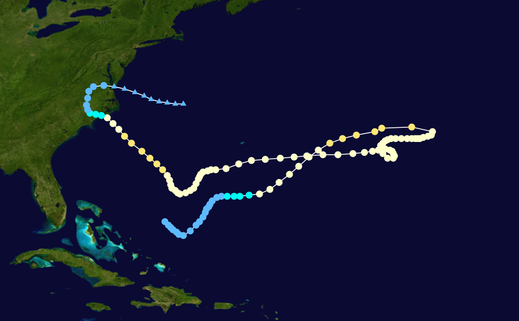
The hurricane is moving northward at 8 kt on the west side of a
subtropical ridge. This motion is expected to continue for 2 to 3
days while the steering pattern persists. Thereafter, a trough
currently over central Canada is expected to move eastward and
should cause Jose to turn to the northeast and east at a slow
forward speed in the 3- to 5-day time frame. The NHC track
forecast has been shifted slightly to the left of the previous one,
mainly because of the more westward initial position.

KEY MESSAGES:

1. The center of Jose is forecast to pass well east of the North
Carolina coast on Monday, and tropical-storm-force winds are
currently expected to remain offshore of the North Carolina Outer
Banks. However, an additional increase in the size of the storm or a
westward adjustment in the track forecast could bring tropical storm
conditions closer to the Outer Banks, and interests there should
monitor the progress of Jose through Monday.

2. While the center of Jose is currently forecast to remain offshore
of the U.S. coast, the large cyclone could cause some direct impacts
from Virginia northward to New England, and any deviation to the
left of the NHC forecast track would increase the likelihood and
magnitude of those impacts. Interests along the U.S. east coast
from Virginia to New England should monitor the progress of Jose
through the next several days. Tropical storm watches could be
required for a portion of this area later today.

3. Swells generated by Jose are affecting Bermuda, the Bahamas,
and much of the U.S. east coast. These swells are likely to cause
dangerous surf and rip current conditions for the next several days
in these areas.

FORECAST POSITIONS AND MAX WINDS

INIT 17/1500Z 31.0N 71.9W 80 KT 90 MPH
12H 18/0000Z 32.0N 71.8W 80 KT 90 MPH
24H 18/1200Z 33.6N 71.8W 75 KT 85 MPH
36H 19/0000Z 35.2N 71.8W 70 KT 80 MPH
48H 19/1200Z 36.7N 71.8W 70 KT 80 MPH
72H 20/1200Z 39.6N 70.4W 60 KT 70 MPH
96H 21/1200Z 40.0N 67.5W 55 KT 65 MPH
120H 22/1200Z 39.5N 65.5W 50 KT 60 MPH...POST-TROPICAL

$$
Forecaster Cangialosi

NNNN
0 likes   
My posts are only my opinions and NOT official forecasts. For official forecasts, consult the National Hurricane Center or the National Weather Service.

Irene 11', Sandy 12', Fay 20’, Isaias 20’, Elsa 21’, Henri 21’, Ida 21’

User avatar
Buck
Category 5
Category 5
Posts: 1128
Joined: Fri Sep 10, 2004 12:04 pm
Location: Atlanta, GA

Re: ATL: JOSE - Hurricane - Discussion

#643 Postby Buck » Sun Sep 17, 2017 12:44 pm

Which storms (if any) have featured 2 notable loops in their track?
0 likes   

User avatar
1900hurricane
Category 5
Category 5
Posts: 6044
Age: 32
Joined: Fri Feb 06, 2015 12:04 pm
Location: Houston, TX
Contact:

Re: ATL: JOSE - Hurricane - Discussion

#644 Postby 1900hurricane » Sun Sep 17, 2017 1:08 pm

Buck wrote:Which storms (if any) have featured 2 notable loops in their track?

Wayne '86 is the first that came to mind for me. Ginger '71, Rewa '93-'94, and Nadine '12 were also somewhat loopy.

Image

Image

Image

Image
1 likes   
Contract Meteorologist. TAMU & MSST. Fiercely authentic, one of a kind. We are all given free will, so choose a life meant to be lived. We are the Masters of our own Stories.
Opinions expressed are mine alone.

Follow me on Twitter at @1900hurricane : Read blogs at https://1900hurricane.wordpress.com/

Vdogg
Category 2
Category 2
Posts: 619
Joined: Wed Aug 31, 2016 9:56 am

Re: ATL: JOSE - Hurricane - Discussion

#645 Postby Vdogg » Sun Sep 17, 2017 1:34 pm

Things are oddly silent in here considering that the Euro shows a pretty decent size hurricane parking itself right off of New Jersey and Long Island on Wednesday. I mean, I know it's not Florida, but still.
8 likes   

tpinnola
Tropical Low
Tropical Low
Posts: 17
Joined: Tue Sep 05, 2017 5:33 pm

Re: ATL: JOSE - Hurricane - Discussion

#646 Postby tpinnola » Sun Sep 17, 2017 1:52 pm

Vdogg wrote:Things are oddly silent in here considering that the Euro shows a pretty decent size hurricane parking itself right off of New Jersey and Long Island on Wednesday. I mean, I know it's not Florida, but still.


Couldn't agree more. What am I missing? Figured there would be way more posts here
2 likes   
Not an expert.

User avatar
Happy Pelican
S2K Supporter
S2K Supporter
Posts: 119
Joined: Tue Sep 29, 2015 11:12 pm
Location: Pelican Island, Jersey Shore

Re: ATL: JOSE - Hurricane - Discussion

#647 Postby Happy Pelican » Sun Sep 17, 2017 2:06 pm

Vdogg wrote:Things are oddly silent in here considering that the Euro shows a pretty decent size hurricane parking itself right off of New Jersey and Long Island on Wednesday. I mean, I know it's not Florida, but still.


I agree. I'm extremely worried about flooding. The thoughts of living in another disaster zone makes me sick. My generator crapped out from when contractor took off and we still hadn't had utilities reconnected from the house elevation. In the financial bell jar and the active Atlantic is really stressing me out.
2 likes   

Aric Dunn
Category 5
Category 5
Posts: 21228
Age: 41
Joined: Sun Sep 19, 2004 9:58 pm
Location: Ready for the Chase.
Contact:

Re: ATL: JOSE - Hurricane - Discussion

#648 Postby Aric Dunn » Sun Sep 17, 2017 2:16 pm

Looks like Jose is continuing this NNE motion... also with 30 to 40 kts of shear currently the center is on the verge of becoming exposed.. there is almost no convection to the south of the center..

all mostly baroclinic enhancement at this point.. honestly looks like it has already started the very very beginnings of transitioning .
2 likes   
Note: If I make a post that is brief. Please refer back to previous posts for the analysis or reasoning. I do not re-write/qoute what my initial post said each time.
If there is nothing before... then just ask :)

Space & Atmospheric Physicist, Embry-Riddle Aeronautical University,
I believe the sky is falling...

Vdogg
Category 2
Category 2
Posts: 619
Joined: Wed Aug 31, 2016 9:56 am

Re: ATL: JOSE - Hurricane - Discussion

#649 Postby Vdogg » Sun Sep 17, 2017 2:31 pm

Aric Dunn wrote:Looks like Jose is continuing this NNE motion... also with 30 to 40 kts of shear currently the center is on the verge of becoming exposed.. there is almost no convection to the south of the center..

all mostly baroclinic enhancement at this point.. honestly looks like it has already started the very very beginnings of transitioning .

This would tend to lead to an expanded wind field correct?
1 likes   

Aric Dunn
Category 5
Category 5
Posts: 21228
Age: 41
Joined: Sun Sep 19, 2004 9:58 pm
Location: Ready for the Chase.
Contact:

Re: ATL: JOSE - Hurricane - Discussion

#650 Postby Aric Dunn » Sun Sep 17, 2017 2:54 pm

Vdogg wrote:
Aric Dunn wrote:Looks like Jose is continuing this NNE motion... also with 30 to 40 kts of shear currently the center is on the verge of becoming exposed.. there is almost no convection to the south of the center..

all mostly baroclinic enhancement at this point.. honestly looks like it has already started the very very beginnings of transitioning .

This would tend to lead to an expanded wind field correct?


Yes but weaker...
1 likes   
Note: If I make a post that is brief. Please refer back to previous posts for the analysis or reasoning. I do not re-write/qoute what my initial post said each time.
If there is nothing before... then just ask :)

Space & Atmospheric Physicist, Embry-Riddle Aeronautical University,
I believe the sky is falling...

User avatar
weathaguyry
Category 5
Category 5
Posts: 1272
Age: 20
Joined: Wed Jun 15, 2016 5:16 am
Location: Long Island, NY

Re: ATL: JOSE - Hurricane - Discussion

#651 Postby weathaguyry » Sun Sep 17, 2017 3:11 pm

I wonder if there will be TS watches at 5PM
1 likes   
My posts are only my opinions and NOT official forecasts. For official forecasts, consult the National Hurricane Center or the National Weather Service.

Irene 11', Sandy 12', Fay 20’, Isaias 20’, Elsa 21’, Henri 21’, Ida 21’

clipper35
Tropical Low
Tropical Low
Posts: 38
Joined: Tue Sep 07, 2004 6:09 pm
Location: warwick ri

Re: ATL: JOSE - Hurricane - Discussion

#652 Postby clipper35 » Sun Sep 17, 2017 3:50 pm

Tropical storm watches are now in effect for the southern New England coastline as of 5 pm nhc update
1 likes   

User avatar
Happy Pelican
S2K Supporter
S2K Supporter
Posts: 119
Joined: Tue Sep 29, 2015 11:12 pm
Location: Pelican Island, Jersey Shore

Re: ATL: JOSE - Hurricane - Discussion

#653 Postby Happy Pelican » Sun Sep 17, 2017 4:46 pm

Oh goodie. Any Jersey shore people have an extra generator? :ggreen:
1 likes   

psyclone
S2K Supporter
S2K Supporter
Posts: 4487
Joined: Wed Aug 24, 2005 9:04 pm
Location: palm harbor fl

Re: ATL: JOSE - Hurricane - Discussion

#654 Postby psyclone » Sun Sep 17, 2017 5:03 pm

Jose has a giant windfield common in well aged hurricanes. If it follows the projected track it should be a fun system for the northeast hopefully bringing interesting but not destructive weather.
3 likes   

Aric Dunn
Category 5
Category 5
Posts: 21228
Age: 41
Joined: Sun Sep 19, 2004 9:58 pm
Location: Ready for the Chase.
Contact:

Re: ATL: JOSE - Hurricane - Discussion

#655 Postby Aric Dunn » Sun Sep 17, 2017 5:12 pm

recon turning ne from the estimated postion.. becasue its not there.. its been moving nne almost all day..

though the last hour looks like it has swung back more northerly.
1 likes   
Note: If I make a post that is brief. Please refer back to previous posts for the analysis or reasoning. I do not re-write/qoute what my initial post said each time.
If there is nothing before... then just ask :)

Space & Atmospheric Physicist, Embry-Riddle Aeronautical University,
I believe the sky is falling...

User avatar
1900hurricane
Category 5
Category 5
Posts: 6044
Age: 32
Joined: Fri Feb 06, 2015 12:04 pm
Location: Houston, TX
Contact:

Re: ATL: JOSE - Hurricane - Discussion

#656 Postby 1900hurricane » Sun Sep 17, 2017 8:38 pm

Jose is a weird one. Structure has improved, but the center is still tilted to the north with increasing height. Recon is also starting to show a funky wind field with the strongest winds well removed from the center in the eastern semicircle. Baroclinic forces are clearly coming into play now. Jose is still mostly, but no longer completely 100% tropical.

Image

Image

Image
1 likes   
Contract Meteorologist. TAMU & MSST. Fiercely authentic, one of a kind. We are all given free will, so choose a life meant to be lived. We are the Masters of our own Stories.
Opinions expressed are mine alone.

Follow me on Twitter at @1900hurricane : Read blogs at https://1900hurricane.wordpress.com/

User avatar
weathaguyry
Category 5
Category 5
Posts: 1272
Age: 20
Joined: Wed Jun 15, 2016 5:16 am
Location: Long Island, NY

Re: ATL: JOSE - Hurricane - Discussion

#657 Postby weathaguyry » Sun Sep 17, 2017 8:54 pm

I can't say I'm sad about the flashlight purchase for when the GFS was showing Irma as a Cat 4 into NYC :D
2 likes   
My posts are only my opinions and NOT official forecasts. For official forecasts, consult the National Hurricane Center or the National Weather Service.

Irene 11', Sandy 12', Fay 20’, Isaias 20’, Elsa 21’, Henri 21’, Ida 21’

User avatar
1900hurricane
Category 5
Category 5
Posts: 6044
Age: 32
Joined: Fri Feb 06, 2015 12:04 pm
Location: Houston, TX
Contact:

Re: ATL: JOSE - Hurricane - Discussion

#658 Postby 1900hurricane » Sun Sep 17, 2017 9:56 pm

2 likes   
Contract Meteorologist. TAMU & MSST. Fiercely authentic, one of a kind. We are all given free will, so choose a life meant to be lived. We are the Masters of our own Stories.
Opinions expressed are mine alone.

Follow me on Twitter at @1900hurricane : Read blogs at https://1900hurricane.wordpress.com/

User avatar
Bizzles
Category 1
Category 1
Posts: 472
Age: 38
Joined: Wed Oct 27, 2010 10:22 am
Location: Columbus, NJ

Re: ATL: JOSE - Hurricane - Discussion

#659 Postby Bizzles » Sun Sep 17, 2017 10:20 pm

Vdogg wrote:Things are oddly silent in here considering that the Euro shows a pretty decent size hurricane parking itself right off of New Jersey and Long Island on Wednesday. I mean, I know it's not Florida, but still.

I believe you'll find everyone over in the Maria thread...
4 likes   
Andrew '92 Opal '95 Blizzard '96 Izzy '03 Irene '11 Sandy '12

The following post is NOT an official forecast and should not be used as such. It is just the opinion is not be backed by sound meteorological data. It is NOT endorsed by any professional institution including storm2k.org For Official Information please refer to the NHC and NWS products.

Aric Dunn
Category 5
Category 5
Posts: 21228
Age: 41
Joined: Sun Sep 19, 2004 9:58 pm
Location: Ready for the Chase.
Contact:

Re: ATL: JOSE - Hurricane - Discussion

#660 Postby Aric Dunn » Mon Sep 18, 2017 12:29 am

I love how this has been moving nne for the last 18 hours.. but officially its still north.. even though the moment the new forecast is issued it moves nne off track.. so ridiculous.
0 likes   
Note: If I make a post that is brief. Please refer back to previous posts for the analysis or reasoning. I do not re-write/qoute what my initial post said each time.
If there is nothing before... then just ask :)

Space & Atmospheric Physicist, Embry-Riddle Aeronautical University,
I believe the sky is falling...


Return to “2017”

Who is online

Users browsing this forum: No registered users and 23 guests