ATL: ALBERTO - Post-Tropical

Moderator: S2k Moderators

Message
Author
User avatar
Bocadude85
Category 5
Category 5
Posts: 2941
Age: 37
Joined: Mon Apr 18, 2005 2:20 pm
Location: Honolulu,Hi

Re: ATL: INVEST 90L - Models

#201 Postby Bocadude85 » Tue May 22, 2018 5:50 pm

Aric Dunn wrote:
Bocadude85 wrote:
Aric Dunn wrote:
Not one person is questioning the rainfall over florida... in either camp..


If that’s the case then who cares where a weather less LLC makes landfall? The rainfall is the story of this system.


Science.....


Ok and past experience has told many of us that a weak LLC will follow the convention...so what makes the GFS solution so unreasonable?
0 likes   

Aric Dunn
Category 5
Category 5
Posts: 21228
Age: 41
Joined: Sun Sep 19, 2004 9:58 pm
Location: Ready for the Chase.
Contact:

Re: ATL: INVEST 90L - Models

#202 Postby Aric Dunn » Tue May 22, 2018 5:51 pm

Bocadude85 wrote:
Aric Dunn wrote:
Bocadude85 wrote:
If that’s the case then who cares where a weather less LLC makes landfall? The rainfall is the story of this system.


Science.....


Ok and past experience has told many of us that a weak LLC will follow the convention...so what makes the GFS solution so unreasonable?


read the numerous previous pages for the multiple scenarios.. and in the discussion
3 likes   
Note: If I make a post that is brief. Please refer back to previous posts for the analysis or reasoning. I do not re-write/qoute what my initial post said each time.
If there is nothing before... then just ask :)

Space & Atmospheric Physicist, Embry-Riddle Aeronautical University,
I believe the sky is falling...

ava_ati
Tropical Storm
Tropical Storm
Posts: 174
Joined: Thu Sep 01, 2016 8:36 am
Location: Saint Augustine

Re: ATL: INVEST 90L - Discussion

#203 Postby ava_ati » Tue May 22, 2018 5:52 pm

AJC3 wrote:
Will the GFS wind up being closer to what actually takes place? Given the upper wind profile, I think it's a reasonable assumption. Could the ECM verify? Sure, it could. However, there's little doubt in my mind that BE (divergent jet forced ascent) processes will play a role in lowering surface pressures over the Gulf and this will occur east of the mid-upper level low, rather than directly beneath it. I think what most folks here (including my fellow blue-taggers) agree upon, is that this will be a sloppy, right sided system. It seems that where we differ the most is just how far east the precip shield with the highest QPF will be. To be honest, I wouldn't mind being wrong in this case. If the heavy precip swath stays out over the eastern Gulf...hey, we'll take it here on the peninsula.


The worst part for Florida is that this isn't going to get any better once this system is past us. I'm not especially worried about whatever this Low forms into but it is the rainfall we have already had, this system and the rain that is going to come after the system that has me worried.
0 likes   

User avatar
TheStormExpert
Category 5
Category 5
Posts: 8487
Age: 30
Joined: Wed Feb 16, 2011 5:38 pm
Location: Palm Beach Gardens, FL

Re: ATL: INVEST 90L - Models

#204 Postby TheStormExpert » Tue May 22, 2018 5:59 pm

Despite shear likely limiting much if any development in the GoM it’s been actually below average there as of lately.

 https://twitter.com/michaelrlowry/status/999030348934770691


0 likes   
The following post is NOT an official forecast and should not be used as such. It is just the opinion of the poster and may or may not be backed by sound meteorological data. It is NOT endorsed by storm2k.org.

User avatar
CyclonicFury
Category 5
Category 5
Posts: 1974
Age: 25
Joined: Sun Jul 02, 2017 12:32 pm
Location: NC
Contact:

Re: ATL: INVEST 90L - Discussion

#205 Postby CyclonicFury » Tue May 22, 2018 6:11 pm

I would not be surprised if this became a named tropical storm anyway despite the shear. Early season gyre storms have formed in strong shear before: think Andrea 2013, Colin 2016 and Cindy 2017 for some recent examples. Regardless, heavy rain is the main threat, but I think it has a decent chance to become named this weekend based on the models except for the GFS.
0 likes   
NCSU B.S. in Meteorology Class of 2021. Tropical weather blogger at http://www.cyclonicfury.com. My forecasts and thoughts are NOT official, for official forecasts please consult the National Hurricane Center.

User avatar
AJC3
Admin
Admin
Posts: 3871
Age: 60
Joined: Tue Aug 31, 2004 7:04 pm
Location: West Melbourne, Florida
Contact:

Re: ATL: INVEST 90L - Models

#206 Postby AJC3 » Tue May 22, 2018 6:11 pm

Bocadude85 wrote:
Aric Dunn wrote:
Bocadude85 wrote:
We have two pro Mets in the GFS camp and from my experience it’s hard to go against what they say, another 10-20 inches of rainfall will cause significant flooding in South and Central Florida.


Not one person is questioning the rainfall over florida... in either camp..


If that’s the case then who cares where a weather less LLC makes landfall? The rainfall is the story of this system.


You're exactly right in that rainfall is the big story here. But even though the main global models agree on this being a sheared/sloppy right sided system, the reason (or at least one of them) why I think there's probably so much discussion/debate about this is because there's a pretty substantial difference in the QPF fields through Sunday night over a couple of land areas of note. The first is across the southern third of Florida. the GFS shows 4-7" areal average there, while the ECM shows about half that much. The second is from SELA across southern MS/AL. The ECM shows about 3-6" in this area, while the GFS shows about half of that. The difference in the fields are quite apparent over the eastern half of the GOMEX. The ECM is much wetter there. And these differences become even more pronounced early next week!

We've found that local precip maxima in tropical rainfall events is usually between 2 and 3x the forecast areal averages. This could be very significant. Some of the areas where the GFS is showing those additional rains have already received nearly a foot and half of rain.
5 likes   

User avatar
DestinHurricane
Category 4
Category 4
Posts: 930
Joined: Tue May 01, 2018 8:05 am
Location: Columbus, OH... need to get back in the action

Re: ATL: INVEST 90L - Discussion

#207 Postby DestinHurricane » Tue May 22, 2018 6:13 pm

Should the 5 day chances go up at the 8PM STWO
0 likes   
Destin/Santa Rosa Beach, Florida: Ivan 2004, Dennis 2005, Michael 2018, Sally 2020

Fort Lauderdale, Florida Eta 2020, Many future storms!

THE Ohio State University: :cold:

User avatar
CyclonicFury
Category 5
Category 5
Posts: 1974
Age: 25
Joined: Sun Jul 02, 2017 12:32 pm
Location: NC
Contact:

Re: ATL: INVEST 90L - Discussion

#208 Postby CyclonicFury » Tue May 22, 2018 6:17 pm

000
ABNT20 KNHC 222314
TWOAT

Special Tropical Weather Outlook
NWS National Hurricane Center Miami FL
715 PM EDT Tue May 22 2018

For the North Atlantic...Caribbean Sea and the Gulf of Mexico:

A broad surface low centered just east of Belize is producing a
large area of cloudiness and showers extending from the northwestern
Caribbean Sea across Cuba and into the Florida peninsula. Little
development is expected during the next couple of days due to strong
upper-level winds and proximity to the Yucatan Peninsula of Mexico.
However, gradual subtropical or tropical development is possible
late this week while the system moves slowly into the central or
eastern Gulf of Mexico. Regardless of development, locally heavy
rainfall is possible across western Cuba, the Cayman Islands, and
much of Florida during the next several days. For more information
on the heavy rain threat, please see products issued by your local
weather office. The next Special Tropical Weather Outlook on this
system will be issued by 800 AM EDT on Wednesday.
* Formation chance through 48 hours...low...near 0 percent.
* Formation chance through 5 days...medium...50 percent.

$$
Forecaster Beven
2 likes   
NCSU B.S. in Meteorology Class of 2021. Tropical weather blogger at http://www.cyclonicfury.com. My forecasts and thoughts are NOT official, for official forecasts please consult the National Hurricane Center.

User avatar
CyclonicFury
Category 5
Category 5
Posts: 1974
Age: 25
Joined: Sun Jul 02, 2017 12:32 pm
Location: NC
Contact:

Re: ATL: INVEST 90L - Models

#209 Postby CyclonicFury » Tue May 22, 2018 6:27 pm

18z GEFS is bullish on a Big Bend area TS, which fits in line with climatology.
Image
1 likes   
NCSU B.S. in Meteorology Class of 2021. Tropical weather blogger at http://www.cyclonicfury.com. My forecasts and thoughts are NOT official, for official forecasts please consult the National Hurricane Center.

User avatar
cycloneye
Admin
Admin
Posts: 139059
Age: 67
Joined: Thu Oct 10, 2002 10:54 am
Location: San Juan, Puerto Rico

Re: ATL: INVEST 90L - Discussion: STWO - 0%-50%

#210 Postby cycloneye » Tue May 22, 2018 6:28 pm

Image
2 likes   
Visit the Caribbean-Central America Weather Thread where you can find at first post web cams,radars
and observations from Caribbean basin members Click Here

User avatar
northjaxpro
S2K Supporter
S2K Supporter
Posts: 8900
Joined: Mon Sep 27, 2010 11:21 am
Location: Jacksonville, FL

Re: ATL: INVEST 90L - Discussion: STWO - 0%-50%

#211 Postby northjaxpro » Tue May 22, 2018 6:35 pm

NHC upped the development probability over 120 hours at 50% now.

Boatload of rain in store for us in Florida for days and days to come as I am sticking with the solution.the GFS has shown us the entire time.
6 likes   
NEVER, EVER SAY NEVER in the tropics and weather in general, and most importantly, with life itself!!

________________________________________________________________________________________

Fay 2008 Beryl 2012 Debby 2012 Colin 2016 Hermine 2016 Julia 2016 Matthew 2016 Irma 2017 Dorian 2019

User avatar
gatorcane
S2K Supporter
S2K Supporter
Posts: 23499
Age: 46
Joined: Sun Mar 13, 2005 3:54 pm
Location: Boca Raton, FL

Re: ATL: INVEST 90L - Models

#212 Postby gatorcane » Tue May 22, 2018 6:57 pm

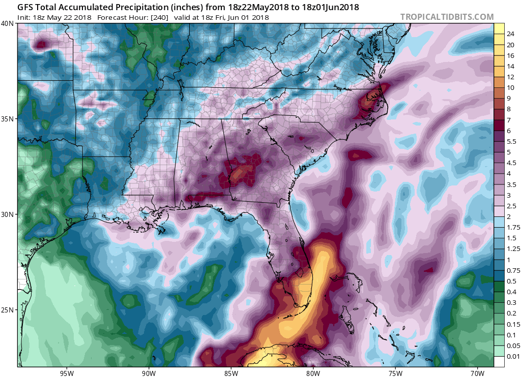
The GFS op continues to show significant rainfalls for SE Florida for the next 10 days partly due to 90l:

Image
0 likes   

User avatar
gatorcane
S2K Supporter
S2K Supporter
Posts: 23499
Age: 46
Joined: Sun Mar 13, 2005 3:54 pm
Location: Boca Raton, FL

Re: ATL: INVEST 90L - Models

#213 Postby gatorcane » Tue May 22, 2018 7:05 pm

12Z UKMET a lot like the GFS:

Image
1 likes   

Aric Dunn
Category 5
Category 5
Posts: 21228
Age: 41
Joined: Sun Sep 19, 2004 9:58 pm
Location: Ready for the Chase.
Contact:

Re: ATL: INVEST 90L - Models

#214 Postby Aric Dunn » Tue May 22, 2018 7:08 pm

gatorcane wrote:12Z UKMET a lot like the GFS:

Image


IT also does not look tropical....
0 likes   
Note: If I make a post that is brief. Please refer back to previous posts for the analysis or reasoning. I do not re-write/qoute what my initial post said each time.
If there is nothing before... then just ask :)

Space & Atmospheric Physicist, Embry-Riddle Aeronautical University,
I believe the sky is falling...

User avatar
TheStormExpert
Category 5
Category 5
Posts: 8487
Age: 30
Joined: Wed Feb 16, 2011 5:38 pm
Location: Palm Beach Gardens, FL

Re: ATL: INVEST 90L - Discussion

#215 Postby TheStormExpert » Tue May 22, 2018 7:31 pm

Interesting Twitter discussion by Philippe Papin on Invest 90L and its CAG (Central American Gyre) origin and key aspects of this kind of originating TC potential.

 https://twitter.com/pppapin/status/999069322298343424


 https://twitter.com/pppapin/status/999069328237514752


 https://twitter.com/pppapin/status/999069335124504576


 https://twitter.com/pppapin/status/999069343668359168


 https://twitter.com/pppapin/status/999069346713358336


10 likes   
The following post is NOT an official forecast and should not be used as such. It is just the opinion of the poster and may or may not be backed by sound meteorological data. It is NOT endorsed by storm2k.org.

User avatar
cycloneye
Admin
Admin
Posts: 139059
Age: 67
Joined: Thu Oct 10, 2002 10:54 am
Location: San Juan, Puerto Rico

Re: ATL: INVEST 90L - Discussion

#216 Postby cycloneye » Tue May 22, 2018 8:18 pm

00z Best Track:

Location: 17.3°N 87.2°W
Maximum Winds: 25 kt
Minimum Central Pressure: 1008 mb


Image
0 likes   
Visit the Caribbean-Central America Weather Thread where you can find at first post web cams,radars
and observations from Caribbean basin members Click Here

User avatar
cycloneye
Admin
Admin
Posts: 139059
Age: 67
Joined: Thu Oct 10, 2002 10:54 am
Location: San Juan, Puerto Rico

Re: ATL: INVEST 90L - Models

#217 Postby cycloneye » Tue May 22, 2018 8:20 pm

00z SHIP

Code: Select all

   * ATLANTIC     SHIPS INTENSITY FORECAST          *
                    * IR SAT DATA PROXY USED,      OHC AVAILABLE     *
                    *  INVEST      AL902018  05/23/18  00 UTC        *

TIME (HR)          0     6    12    18    24    36    48    60    72    84    96   108   120
V (KT) NO LAND    25    26    27    28    29    28    30    28    33    36    36    36    35
V (KT) LAND       25    26    27    28    29    28    30    28    33    36    36    36    35
V (KT) LGEM       25    25    25    25    24    23    22    22    21    21    21    20    20
Storm Type      TROP  TROP  TROP  TROP  TROP  TROP  TROP  TROP  TROP  TROP  TROP  TROP  TROP

SHEAR (KT)        21    23    22    21    22    19    23    22    26    25    21    20    21
SHEAR ADJ (KT)     0     0     2     0     1     0     4    -1     1     0     6     2     7
SHEAR DIR        266   268   269   270   263   271   242   248   240   263   228   237   227
SST (C)         28.9  28.9  28.9  28.9  28.9  28.8  28.6  28.5  28.3  28.0  26.5  25.7  23.8
POT. INT. (KT)   145   145   145   145   146   145   142   141   140   138   123   116   101
ADJ. POT. INT.   128   129   129   129   130   130   127   128   130   133   119   112    94
200 MB T (C)   -53.2 -53.5 -53.7 -53.3 -53.0 -53.5 -52.7 -53.4 -52.9 -53.5 -53.0 -54.1 -54.4
200 MB VXT (C)   0.4   0.6   0.5   0.5   0.5   0.4   0.7   0.5   0.7   0.4   0.8   0.0   0.0
TH_E DEV (C)       9     8     7     9     9     7     9     7     8     6     6     4     4
700-500 MB RH     65    67    66    66    68    68    73    70    73    72    75    76    74
MODEL VTX (KT)     8     8     7     8     8     6     8     7    11    14    13  LOST  LOST
850 MB ENV VOR    52    56    49    47    43    39    68    73    86    66    71    17    55
200 MB DIV        39    41    48    48    59    20    50    64    93    63   100    75   119
700-850 TADV       0    -3    -4     0     0    -3    -3     0     4    15    21    45    34
LAND (KM)        106    95    84    74    84   107   143   195   272   171    71   147    25
LAT (DEG N)     17.3  17.3  17.3  17.4  17.5  17.6  17.8  18.0  19.0  20.5  23.7  28.2  33.4
LONG(DEG W)     87.2  87.3  87.4  87.5  87.4  87.0  86.4  85.8  84.9  83.3  81.0  79.0  78.9
STM SPEED (KT)     0     1     1     1     2     2     3     4     9    15    22    26    25
HEAT CONTENT      40    40    40    39    38    40    47    55    58    52    10     0     0

  FORECAST TRACK FROM TABM      INITIAL HEADING/SPEED (DEG/KT):  0/  0      CX,CY:   0/  0
  T-12 MAX WIND:  25            PRESSURE OF STEERING LEVEL (MB):  561  (MEAN=618)
  GOES IR BRIGHTNESS TEMP. STD DEV.  50-200 KM RAD:  19.9 (MEAN=14.5)
  % GOES IR PIXELS WITH T < -20 C    50-200 KM RAD:  38.0 (MEAN=65.0)
  PRELIM RI PROB (DV .GE. 55 KT IN 48 HR):            0.1

                        INDIVIDUAL CONTRIBUTIONS TO INTENSITY CHANGE
                         6   12   18   24   36   48   60   72   84   96  108  120
                        ----------------------------------------------------------
  SAMPLE MEAN CHANGE     1.   2.   3.   4.   6.   8.   9.  10.  11.  12.  13.  13.
  SST POTENTIAL          1.   1.   1.   3.   6.  11.  16.  21.  25.  28.  29.  30.
  VERTICAL SHEAR MAG     1.   1.   2.   2.   1.  -1.  -4.  -7. -10. -12. -14. -16.
  VERTICAL SHEAR ADJ     0.  -0.   0.   0.   0.  -0.   0.   1.   1.   0.  -0.  -1.
  VERTICAL SHEAR DIR    -0.  -1.  -1.  -2.  -3.  -4.  -6.  -7.  -8.  -9.  -9.  -8.
  PERSISTENCE           -0.  -1.  -1.  -1.  -1.  -1.  -1.  -1.  -0.   0.   0.   1.
  200/250 MB TEMP.      -0.  -0.  -0.  -0.  -1.  -1.  -1.  -1.  -1.  -2.  -1.  -1.
  THETA_E EXCESS         0.  -0.   0.   0.  -0.  -0.  -0.  -0.  -1.  -1.  -1.  -2.
  700-500 MB RH         -0.  -0.  -0.  -1.  -1.  -2.  -4.  -5.  -6.  -6.  -6.  -6.
  MODEL VTX TENDENCY    -0.  -1.  -0.  -0.  -3.  -2.  -4.   0.   3.   2.   1.   0.
  850 MB ENV VORTICITY   0.   0.   0.   0.   0.   1.   1.   2.   2.   2.   2.   2.
  200 MB DIVERGENCE      0.   0.   0.   0.   0.   0.   0.   1.   1.   1.   0.  -1.
  850-700 T ADVEC        0.  -0.  -0.  -0.  -0.  -0.  -1.  -1.  -0.   0.   1.   1.
  ZONAL STORM MOTION     0.  -0.  -0.  -0.  -1.  -1.  -1.  -1.  -2.  -2.  -3.  -3.
  STEERING LEVEL PRES    0.   0.   0.   0.   0.   0.   0.   1.   1.   0.   0.   0.
  DAYS FROM CLIM. PEAK   0.   0.   0.   0.   0.   0.   1.   1.   1.   2.   2.   2.
  GOES PREDICTORS       -0.  -1.  -1.  -1.  -2.  -3.  -3.  -4.  -4.  -3.  -3.  -3.
  OCEAN HEAT CONTENT    -0.  -0.  -0.  -0.  -0.  -1.  -1.  -1.  -1.  -1.  -1.  -0.
                        ----------------------------------------------------------
  TOTAL CHANGE           1.   2.   3.   4.   3.   5.   3.   8.  11.  11.  11.  10.

                CURRENT MAX WIND (KT):   25. LAT, LON:   17.3    87.2

      ** 2017 ATLANTIC RI INDEX AL902018 INVEST     05/23/18  00 UTC **
 (SHIPS-RII PREDICTOR TABLE for 30 KT OR MORE MAXIMUM WIND INCREASE IN NEXT 24-h)
 
     Predictor             Value   RI Predictor Range  Scaled Value(0-1) % Contribution
 12 HR PERSISTENCE (KT):     0.0     -49.5  to   33.0       0.60         999.0
 850-200 MB SHEAR (KT) :    21.7      30.1  to    2.9       0.31         999.0
 HEAT CONTENT (KJ/cm2) :    39.4       0.0  to  156.2       0.25         999.0
 2nd PC OF IR BR TEMP  :  9999.0       2.4  to   -3.0     999.00         999.0
 STD DEV OF IR BR TEMP :   999.0      36.6  to    2.8     999.00         999.0
 MAXIMUM WIND (kt)     :    25.0      22.5  to  121.0       0.07         999.0
 POT = MPI-VMAX (KT)   :   104.0      28.4  to  139.6       0.68         999.0
 D200 (10**7s-1)       :    47.0     -29.7  to  181.5       0.36         999.0
 BL DRY-AIR FLUX (w/m2):    63.4     961.4  to  -67.1       0.87         999.0
 % AREA WITH TPW <45 mm:    12.6     100.0  to    0.0       0.87         999.0
 
 SHIPS Prob RI for 20kt/ 12hr RI threshold= 999% is 999.0 times sample mean ( 5.4%)
 SHIPS Prob RI for 25kt/ 24hr RI threshold= 999% is 999.0 times sample mean (11.5%)
 SHIPS Prob RI for 30kt/ 24hr RI threshold= 999% is 999.0 times sample mean ( 7.4%)
 SHIPS Prob RI for 35kt/ 24hr RI threshold= 999% is 999.0 times sample mean ( 4.3%)
 SHIPS Prob RI for 40kt/ 24hr RI threshold= 999% is 999.0 times sample mean ( 2.8%)
 SHIPS Prob RI for 45kt/ 36hr RI threshold= 999% is 999.0 times sample mean ( 5.1%)
 SHIPS Prob RI for 55kt/ 48hr RI threshold= 999% is 999.0 times sample mean ( 5.3%)
 SHIPS Prob RI for 65kt/ 72hr RI threshold= 999% is 999.0 times sample mean ( 6.0%)
   
Matrix of RI probabilities
------------------------------------------------------------------------------
  RI (kt / h)  | 20/12 | 25/24 | 30/24 | 35/24 | 40/24 | 45/36 | 55/48  |65/72
------------------------------------------------------------------------------
   SHIPS-RII:   999.0%  999.0%  999.0%  999.0%  999.0%  999.0%  999.0%  999.0%
    Logistic:   999.0%  999.0%  999.0%  999.0%  999.0%  999.0%  999.0%  999.0%
    Bayesian:   999.0%  999.0%  999.0%  999.0%  999.0%  999.0%  999.0%  999.0%
   Consensus:   999.0%  999.0%  999.0%  999.0%  999.0%  999.0%  999.0%  999.0%

   ##         ANNULAR HURRICANE INDEX (AHI) AL902018 INVEST     05/23/18  00 UTC         ##
   ##         ERR=2, BOTH IR FILES BAD OR MISSING

** PROBLTY OF AT LEAST 1 SCNDRY EYEWL FORMTN EVENT AL902018 INVEST     05/23/2018  00 UTC **
TIME(HR)   0-12  12-24(0-24)  24-36(0-36)  36-48(0-48)
CLIMO(%)     0      0(  0)       0(  0)       0(  0)     <-- PROB BASED ON INTENSITY ONLY
PROB(%)      0      0(  0)       0(  0)       0(  0)     PC4 UNAVAIL...MODEL SKILL DEGRADED

** DSHIPS INTENSITY FORECAST ADJUSTED RELATIVE TO ONSET OF ERC WEAKENING PHASE **
      TIME (HR)      0     6    12    18    24    36    48    60    72    84    96   108   120
>24HR AGO (DSHIPS)  25    26    27    28    29    28    30    28    33    36    36    36    35
 18HR AGO           25    24    25    26    27    26    28    26    31    34    34    34    33
 12HR AGO           25    22    21    22    23    22    24    22    27    30    30    30    29
  6HR AGO           25    19    16    15    16    15    17    15    20    23    23    23    22
      NOW                              CURRENT INTENSITY < 83 KT
  IN  6HR                              INTENSITY IN  6HR < 83 KT
  IN 12HR                              INTENSITY IN 12HR < 83 KT
0 likes   
Visit the Caribbean-Central America Weather Thread where you can find at first post web cams,radars
and observations from Caribbean basin members Click Here

User avatar
DestinHurricane
Category 4
Category 4
Posts: 930
Joined: Tue May 01, 2018 8:05 am
Location: Columbus, OH... need to get back in the action

Re: ATL: INVEST 90L - Discussion

#218 Postby DestinHurricane » Tue May 22, 2018 8:34 pm

All storms in this area in may, all but 1 are similar to the GFS solution Image
1 likes   
Destin/Santa Rosa Beach, Florida: Ivan 2004, Dennis 2005, Michael 2018, Sally 2020

Fort Lauderdale, Florida Eta 2020, Many future storms!

THE Ohio State University: :cold:

stormreader
Category 5
Category 5
Posts: 1242
Joined: Fri Jun 24, 2011 10:58 am

Re: ATL: INVEST 90L - Models

#219 Postby stormreader » Tue May 22, 2018 8:47 pm

Euro precip showing system approaching N Central gulf coast with a drift west and stall-meander over S Central anand SW La. Looking at precip.
https://www.facebook.com/katctv3/posts/ ... 4620441969
1 likes   

Aric Dunn
Category 5
Category 5
Posts: 21228
Age: 41
Joined: Sun Sep 19, 2004 9:58 pm
Location: Ready for the Chase.
Contact:

Re: ATL: INVEST 90L - Discussion

#220 Postby Aric Dunn » Tue May 22, 2018 8:49 pm

MId and upper levels are becoming less dry around the system. Could see more convection build overnight.
1 likes   
Note: If I make a post that is brief. Please refer back to previous posts for the analysis or reasoning. I do not re-write/qoute what my initial post said each time.
If there is nothing before... then just ask :)

Space & Atmospheric Physicist, Embry-Riddle Aeronautical University,
I believe the sky is falling...


Return to “2018”

Who is online

Users browsing this forum: No registered users and 92 guests