NWS Tallahassee discussion today 5/23/18
.LONG TERM [Friday Night Through Wednesday]...
The long term is expected to be wet with the focus on a tropical
disturbance and rainfall amounts. Models are still in disagreement
with the track of a tropical disturbance that is currently in the
Caribbean with guidance spanning the eastern and central Gulf of
Mexico as the disturbance moves northward. NHC has given the area
a 50% chance of development in the next five days. Regardless of
if the system does develop though or it`s exact track, significant
rainfall amounts are expected with 7 day rainfall totals of 3-7
inches (locally higher amounts possible). Given these amounts,
will need to closely monitor the long term for flooding. PoPs
remain high through the long term (chance and likely categories)
with no dry days in the forecast. Expect highs in the 80s with
lows in the 70s.
Sure looks like the Panhandle has the potential to get wet from the early model tracks. Inland has been getting more rain than the coast. Will keep a close eye on the system for potential rain and TS development.
ATL: ALBERTO - Post-Tropical
Moderator: S2k Moderators
-
gulf701
- Tropical Depression

- Posts: 58
- Age: 74
- Joined: Mon Jun 14, 2010 4:43 pm
- Location: Wewahitchka, FL
Re: ATL: INVEST 90L - Discussion
0 likes
-
fwbbreeze

- S2K Supporter

- Posts: 885
- Joined: Sun Mar 21, 2004 10:09 pm
- Location: Fort Walton Beach, FL
Re: ATL: INVEST 90L - Discussion
Hey weather peeps!! Great to be back for another season or storm tracking. Check out this twitter link for some great information regarding the genesis of our system this weekend. Not sure how much of the tweet thread will post, but go to his page for the whole dialogue.
https://twitter.com/pppapin/status/999069343668359168
https://twitter.com/pppapin/status/999069343668359168
1 likes
-
PSUHiker31
- Tropical Storm

- Posts: 114
- Joined: Tue Oct 03, 2017 2:36 pm
Re: ATL: INVEST 90L - Discussion
The satellite presentation is certainly looking much improved today. It will be interesting to see how organized it gets after tonight's diurnal max
0 likes
-
stormlover2013
- Category 5

- Posts: 2312
- Joined: Thu Aug 22, 2013 12:06 pm
- Location: Lumberton, Texas
-
Dean4Storms
- S2K Supporter
- Posts: 6355
- Age: 61
- Joined: Sun Aug 31, 2003 1:01 pm
- Location: Miramar Bch. FL
Re: ATL: INVEST 90L - Discussion
I see no clear reason why this Low would dissipate as it tracks over the Yuc. Peninsula, heck most times we have tracked an organizing Low moving NW over the Yuc. it has held steady or deepened.
3 likes
-
Hurricaneman

- Category 5
- Posts: 7280
- Age: 43
- Joined: Tue Aug 31, 2004 3:24 pm
- Location: central florida
Re: ATL: INVEST 90L - Discussion
Looks like the MLC and LLC are not colocated but that was to be expected but I have to wonder if a new center may develop under the MLC as these types of systems like to do which would give the GFS some credence
0 likes
-
gatorcane

- S2K Supporter
- Posts: 23499
- Age: 46
- Joined: Sun Mar 13, 2005 3:54 pm
- Location: Boca Raton, FL
Re: ATL: INVEST 90L - Models
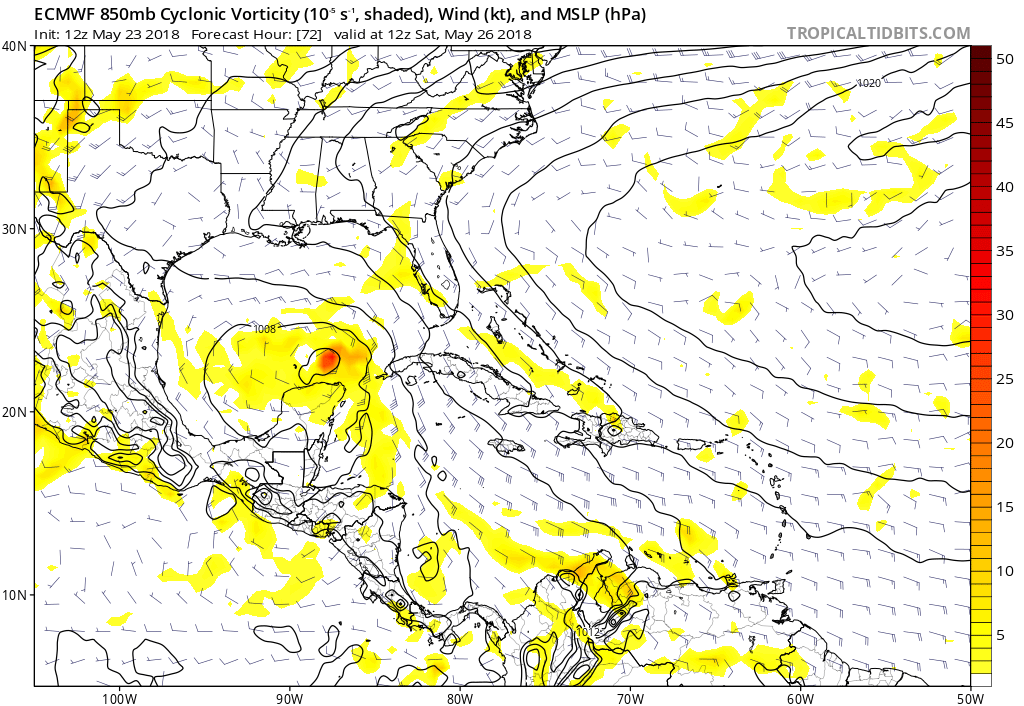
stormlover2013 wrote:I am really interested in the EURO run coming up
Looks like the Euro is coming in more organized through 72 hours than what the 00Z run showed:
1 likes
-
MississippiWx

- S2K Supporter
- Posts: 1535
- Joined: Sat Aug 14, 2010 1:44 pm
- Location: Hattiesburg, Mississippi
Re: ATL: INVEST 90L - Discussion
Definitely a bit more organization occurring this afternoon. Shear is obviously affecting 90L, but thunderstorms are firing much closer to the apparent center today.
0 likes
This post is not an official forecast and should not be used as such. It is just the opinion of MississippiWx and may or may not be backed by sound meteorological data. It is not endorsed by any professional institution including storm2k.org. For Official Information please refer to the NHC and NWS products.
-
Aric Dunn
- Category 5
- Posts: 21228
- Age: 41
- Joined: Sun Sep 19, 2004 9:58 pm
- Location: Ready for the Chase.
- Contact:
Re: ATL: INVEST 90L - Models
Euro Definitely more organized and less broad.
0 likes
Note: If I make a post that is brief. Please refer back to previous posts for the analysis or reasoning. I do not re-write/qoute what my initial post said each time.
If there is nothing before... then just ask
Space & Atmospheric Physicist, Embry-Riddle Aeronautical University,
I believe the sky is falling...
If there is nothing before... then just ask
Space & Atmospheric Physicist, Embry-Riddle Aeronautical University,
I believe the sky is falling...
Re: ATL: INVEST 90L - Models
No graphic, but the euro shifted east, slower, and about the same strength as before. It appears to be Alabama this time.
edit: ha, never mind straight west. I think all the models are on crack on this one.
edit: ha, never mind straight west. I think all the models are on crack on this one.
Last edited by BobHarlem on Wed May 23, 2018 1:26 pm, edited 1 time in total.
0 likes
-
stormlover2013
- Category 5
- Posts: 2312
- Joined: Thu Aug 22, 2013 12:06 pm
- Location: Lumberton, Texas
-
stormlover2013
- Category 5
- Posts: 2312
- Joined: Thu Aug 22, 2013 12:06 pm
- Location: Lumberton, Texas

Re: ATL: INVEST 90L - Discussion
I’m thinking 90L gets more consolidated and than South Florida will have a good weather weekend.
2 likes
-
Aric Dunn
- Category 5
- Posts: 21228
- Age: 41
- Joined: Sun Sep 19, 2004 9:58 pm
- Location: Ready for the Chase.
- Contact:
Re: ATL: INVEST 90L - Models
Yeah not all too surprised there. I was wondering when the models would respond to the upstream trough pushing the ridging east into the plains. ICON did at 12z. Euro was hinting at it a couple days ago. lets see if this pans out. will all depend on placement of trough in the gulf..
0 likes
Note: If I make a post that is brief. Please refer back to previous posts for the analysis or reasoning. I do not re-write/qoute what my initial post said each time.
If there is nothing before... then just ask
Space & Atmospheric Physicist, Embry-Riddle Aeronautical University,
I believe the sky is falling...
If there is nothing before... then just ask
Space & Atmospheric Physicist, Embry-Riddle Aeronautical University,
I believe the sky is falling...
-
FLpanhandle91

- Category 4

- Posts: 956
- Age: 33
- Joined: Mon Sep 13, 2010 3:50 pm
- Location: Fort Walton Beach, FL
Re: ATL: INVEST 90L - Models
Euro through 120 hours has 90L making hard left turn to the west just before 28ºN. due to what looks like slightly stronger riding north of it.
1 likes
Global model run times (CST):
GFS - 0z: 10:30pm, 6z: 4:30am, 12z: 10:30am, 18z: 4:30pm Euro - 0z: 12:30am 12z: 12:30pm
GFS - 0z: 10:30pm, 6z: 4:30am, 12z: 10:30am, 18z: 4:30pm Euro - 0z: 12:30am 12z: 12:30pm
-
SFLcane

- S2K Supporter
- Posts: 9606
- Age: 46
- Joined: Sat Jun 05, 2010 1:44 pm
- Location: Lake Worth Florida
Re: ATL: INVEST 90L - Discussion
IF the latest EURO pans out SFL might get some scattered showers but no heavy rainfall event here. Tricky forecast for sure trying to pinpoint who will see it.
1 likes
-
stormreader
- Category 5
- Posts: 1242
- Joined: Fri Jun 24, 2011 10:58 am
Re: ATL: INVEST 90L - Models
gatorcane wrote:stormlover2013 wrote:I am really interested in the EURO run coming up
Looks like the Euro is coming in more organized through 72 hours than what the 00Z run showed:
And the whole gyre has migrated a little further west than was anticipated a couple of days ago. So lets see if it remains on the west end of the model guidance.
0 likes
-
Bocadude85
- Category 5
- Posts: 2941
- Age: 37
- Joined: Mon Apr 18, 2005 2:20 pm
- Location: Honolulu,Hi
Re: ATL: INVEST 90L - Discussion
boca wrote:I’m thinking 90L gets more consolidated and than South Florida will have a good weather weekend.
I hope so, I am tired of the rain.
0 likes
-
Ivanhater

- Storm2k Moderator

- Posts: 10852
- Age: 37
- Joined: Fri Jul 01, 2005 8:25 am
- Location: Pensacola
Re: ATL: INVEST 90L - Models
Euro would be insane rain for the north central gulf coast...someone post amounts when you can 
2 likes
Michael
-
AtlanticWind

- S2K Supporter
- Posts: 1805
- Age: 65
- Joined: Sun Aug 08, 2004 9:57 pm
- Location: Plantation,Fla
Re: ATL: INVEST 90L - Discussion
boca wrote:I’m thinking 90L gets more consolidated and than South Florida will have a good weather weekend.
Unlikely, this will be a right handed system
0 likes
Who is online
Users browsing this forum: Google Adsense [Bot] and 38 guests