ATL: ALBERTO - Post-Tropical

Moderator: S2k Moderators

Message
Author
Dean4Storms
S2K Supporter
S2K Supporter
Posts: 6355
Age: 61
Joined: Sun Aug 31, 2003 1:01 pm
Location: Miramar Bch. FL

Re: ATL: INVEST 90L - Discussion: Next STWO at 8 PM EDT

#21 Postby Dean4Storms » Mon May 21, 2018 6:03 pm

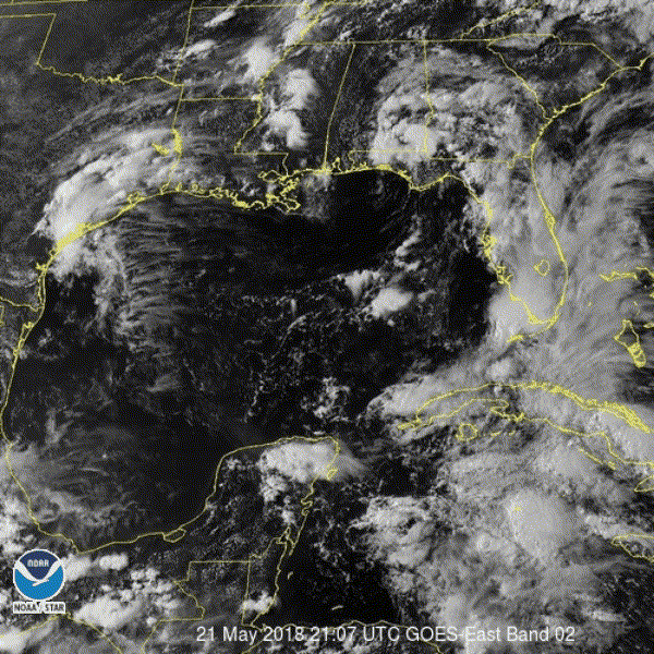
NDG wrote:Vis loop during the day before the sun sets, broad circulation where I place the L is very apparent this afternoon with all the convection sheared to the east of it.
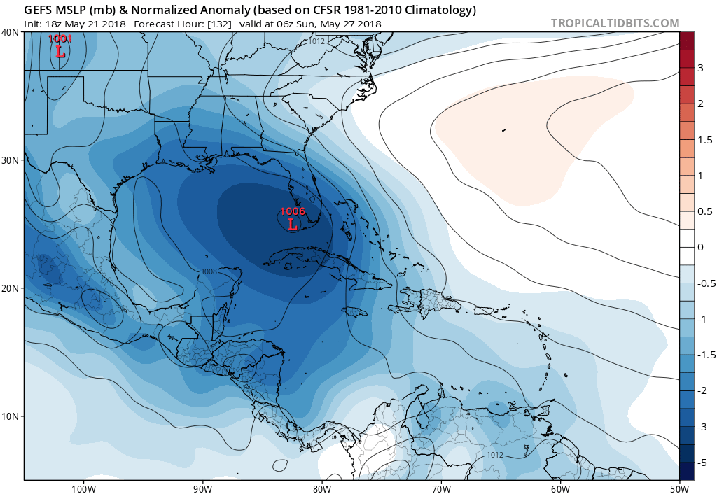
The 18z GFS loses or weakens this vorticity as it moves slowly NW over the next couple of weeks then forecasts for a new one to form by the end of the week just south of Cuba, while Euro never loses or weakens this vorticity over the next couple of days as it moves NW towards the southern GOM.

https://i.imgur.com/RS3knK0.gif


And like the Bay of Campeche that area usually aids in developing surface lows..
0 likes   

tolakram
Admin
Admin
Posts: 19165
Age: 60
Joined: Sun Aug 27, 2006 8:23 pm
Location: Florence, KY (name is Mark)

Re: ATL: INVEST 90L - Discussion: Next STWO at 8 PM EDT

#22 Postby tolakram » Mon May 21, 2018 6:09 pm

Hey, I remembered to change the year on the forum graphic before anyone asked. :D

*sigh* I was wrong, Luis already asked in the mod forum. :lol:
5 likes   
M a r k
- - - - -
Join us in chat: Storm2K Chatroom Invite. Android and IOS apps also available.

The posts in this forum are NOT official forecasts and should not be used as such. Posts are NOT endorsed by any professional institution or STORM2K.org. For official information and forecasts, please refer to NHC and NWS products.

tolakram
Admin
Admin
Posts: 19165
Age: 60
Joined: Sun Aug 27, 2006 8:23 pm
Location: Florence, KY (name is Mark)

Re: ATL: INVEST 90L - Discussion: Next STWO at 8 PM EDT

#23 Postby tolakram » Mon May 21, 2018 6:13 pm

0 likes   
M a r k
- - - - -
Join us in chat: Storm2K Chatroom Invite. Android and IOS apps also available.

The posts in this forum are NOT official forecasts and should not be used as such. Posts are NOT endorsed by any professional institution or STORM2K.org. For official information and forecasts, please refer to NHC and NWS products.

Sciencerocks
Category 5
Category 5
Posts: 7286
Age: 38
Joined: Thu Jul 06, 2017 1:51 am

Re: ATL: INVEST 90L - Discussion: Next STWO at 8 PM EDT

#24 Postby Sciencerocks » Mon May 21, 2018 6:26 pm

Image
2 likes   

User avatar
cycloneye
Admin
Admin
Posts: 139080
Age: 67
Joined: Thu Oct 10, 2002 10:54 am
Location: San Juan, Puerto Rico

Re: ATL: INVEST 90L - Discussion: STWO=0%-40%

#25 Postby cycloneye » Mon May 21, 2018 6:30 pm

Tropical Weather Outlook
NWS National Hurricane Center Miami FL
800 PM EDT Mon May 21 2018

For the North Atlantic...Caribbean Sea and the Gulf of Mexico:

A broad surface low pressure area has formed over the northwestern
Caribbean Sea a couple of hundred miles east of the coast of Belize.
This low and an upper-level trough are producing widespread
cloudiness and showers extending from the northwestern Caribbean
Sea across Cuba and the Florida peninsula. While environmental
conditions are expected to be unfavorable for development during
the next couple of days, some gradual subtropical or tropical
development is possible later this week while the system moves
slowly northward into the central or eastern Gulf of Mexico.
Regardless of development, locally heavy rainfall is possible
across western Cuba and much of Florida during the next several
days. For more information on the heavy rain threat, please see
products issued by your local weather office. The next Special
Tropical Weather Outlook on this system will be issued by 800 AM
EDT on Tuesday.
* Formation chance through 48 hours...low...near 0 percent.
* Formation chance through 5 days...medium...40 percent.

$$
Forecaster Cangialosi


Image
0 likes   
Visit the Caribbean-Central America Weather Thread where you can find at first post web cams,radars
and observations from Caribbean basin members Click Here

User avatar
CDO62
S2K Supporter
S2K Supporter
Posts: 105
Joined: Mon Sep 19, 2005 3:19 pm
Location: Tampa,FL

Re: ATL: INVEST 90L - Discussion: STWO=0%-40%

#26 Postby CDO62 » Mon May 21, 2018 6:43 pm

I'm a little surprised the NHC didn't widen the circle a little more to the East in that graphic with respect to what the GFS has been locked in on.
0 likes   

User avatar
Dylan
Professional-Met
Professional-Met
Posts: 337
Age: 29
Joined: Mon May 31, 2010 9:50 am
Location: New Orleans, LA

Re: ATL: INVEST 90L - Discussion: STWO=0%-40%

#27 Postby Dylan » Mon May 21, 2018 6:54 pm

CDO62 wrote:I'm a little surprised the NHC didn't widen the circle a little more to the East in that graphic with respect to what the GFS has been locked in on.


It’s because they’re well aware that the GFS-OP is a dumpster fire. Even a good portion of the GFS ensembles are to the West with its foreign competition.
8 likes   
Georges('98), Allison('01), Isidore('02), Lili('02), Frances('04) Ivan('04), Cindy('05), Katrina('05), Rita('05), Gustav('08), Isaac('12), Matthew('16), Harvey('17), Irma('17), Nate ('17), Ida ('21).

User avatar
NotSparta
Professional-Met
Professional-Met
Posts: 1648
Age: 22
Joined: Fri Aug 18, 2017 8:24 am
Location: Naples, FL
Contact:

Re: ATL: INVEST 90L - Discussion: Next STWO at 8 PM EDT

#28 Postby NotSparta » Mon May 21, 2018 6:54 pm

TheAustinMan wrote:Latest infrared floater for the invest over the last three hours:

3.12 MB. Source: Generated myself using NOAA/NASA data from GOES-16. This animated GIF is not available from the SSD in this format.
https://i.imgur.com/PO57ePM.gif


I wish floaters were still around like that :(
0 likes   
This post was probably an opinion of mine, and in no way is official. Please refer to http://www.hurricanes.gov for official tropical analysis and advisories.

My website, with lots of tropical wx graphics, including satellite and recon: http://cyclonicwx.com

User avatar
Taffy
Tropical Storm
Tropical Storm
Posts: 221
Joined: Wed Sep 08, 2004 7:05 am
Location: Lehigh Acres/SW Florida

Re: ATL: INVEST 90L - Models

#29 Postby Taffy » Mon May 21, 2018 7:02 pm

Following.
0 likes   
Taffy-SW Florida

Twisted-core
Category 1
Category 1
Posts: 252
Joined: Fri May 11, 2018 9:20 pm

Re: ATL: INVEST 90L - Models

#30 Postby Twisted-core » Mon May 21, 2018 7:05 pm

Image

Image

Hard not to take notice. Likely will be the first tc for the basin
0 likes   

User avatar
gatorcane
S2K Supporter
S2K Supporter
Posts: 23499
Age: 46
Joined: Sun Mar 13, 2005 3:54 pm
Location: Boca Raton, FL

Re: ATL: INVEST 90L - Models

#31 Postby gatorcane » Mon May 21, 2018 7:07 pm

18Z GFS ensemble mean shifted east:

Image
1 likes   

User avatar
wxman57
Moderator-Pro Met
Moderator-Pro Met
Posts: 22482
Age: 66
Joined: Sat Jun 21, 2003 8:06 pm
Location: Houston, TX (southwest)

Re: ATL: INVEST 90L - Discussion: STWO=0%-40%

#32 Postby wxman57 » Mon May 21, 2018 7:15 pm

GFS ensembles are just a little west of the operational, taking the low just off the west coast of Florida and inland near the big bend area of Florida. I like that solution a lot better than any track toward Louisiana across the SW-NE jet core. GFS just has a history of beating the other models in a higher shear environment.
4 likes   

CrazyC83
Professional-Met
Professional-Met
Posts: 33393
Joined: Tue Mar 07, 2006 11:57 pm
Location: Deep South, for the first time!

Re: ATL: INVEST 90L - Discussion: STWO=0%-40%

#33 Postby CrazyC83 » Mon May 21, 2018 7:17 pm

If the jet is set up across Louisiana, any track that way would shear it to death anyway? Although shear is a significant limiting factor no matter what.
1 likes   

CrazyC83
Professional-Met
Professional-Met
Posts: 33393
Joined: Tue Mar 07, 2006 11:57 pm
Location: Deep South, for the first time!

Re: ATL: INVEST 90L - Models

#34 Postby CrazyC83 » Mon May 21, 2018 7:21 pm

SHIPS kills it off quickly.

Code: Select all

  * ATLANTIC     SHIPS INTENSITY FORECAST          *
                    * IR SAT DATA PROXY USED,      OHC AVAILABLE     *
                    *  INVEST      AL902018  05/21/18  18 UTC        *

TIME (HR)          0     6    12    18    24    36    48    60    72    84    96   108   120
V (KT) NO LAND    20    21    22    23    23    24    22    22    20    18    23    23    23
V (KT) LAND       20    21    22    23    23    24    22    22    26    23    28    28    29
V (KT) LGEM       20    20    19    19    18    16   DIS   DIS   DIS   DIS   DIS   DIS   DIS
Storm Type      TROP  TROP  TROP  TROP  TROP  TROP  TROP  TROP  TROP  TROP  TROP  TROP  TROP

SHEAR (KT)        29    29    32    32    30    32    27    36    31    33    27    34    32
SHEAR ADJ (KT)     0     0     0     1     1     0     3     1     2     2     4     0     1
SHEAR DIR        283   272   277   283   284   287   277   266   268   261   283   270   258
SST (C)         28.5  28.5  28.5  28.5  28.4  28.1  27.9  27.6  27.5  27.4  27.2  27.2  27.4
POT. INT. (KT)   142   141   141   141   140   135   133   128   126   125   123   122   126
ADJ. POT. INT.   131   128   127   128   126   121   118   112   109   108   106   105   111
200 MB T (C)   -54.0 -53.8 -54.0 -54.1 -53.7 -53.5 -53.4 -53.4 -53.6 -53.5 -53.7 -53.3 -53.2
200 MB VXT (C)   0.4   0.2   0.3   0.1   0.2   0.3   0.5   0.7   0.7   0.7   0.3   0.4   0.5
TH_E DEV (C)       9    10     9     8    10     9    10     9     9     9     9     9    10
700-500 MB RH     60    62    62    60    58    62    58    57    58    56    54    50    52
MODEL VTX (KT)     5     5     5     5     5     5     5     6     6     6    10    10    11
850 MB ENV VOR    52    65    68    50    40    40    23    31    37    54    64    71    90
200 MB DIV        37    32    42    38    34    42    39    21     0    19    26    22    26
700-850 TADV       0    -2    -2    -2    -1     0    -1     0    -2    -1     3     4     1
LAND (KM)        213   234   222   186   139    74    18   -10    20    64    80    68    65
LAT (DEG N)     17.8  18.0  18.2  18.5  18.8  19.6  20.5  21.2  21.7  22.1  22.3  22.2  22.1
LONG(DEG W)     84.7  85.2  85.5  85.8  86.2  86.7  87.0  87.0  87.1  87.2  87.7  87.8  87.1
STM SPEED (KT)     6     4     4     4     5     4     5     3     2     2     2     2     5
HEAT CONTENT      47    56    64    70    62    36    12    40     7     6     4     3     7

  FORECAST TRACK FROM TABM      INITIAL HEADING/SPEED (DEG/KT):280/  8      CX,CY:  -7/  1
  T-12 MAX WIND:  20            PRESSURE OF STEERING LEVEL (MB):  772  (MEAN=618)
  GOES IR BRIGHTNESS TEMP. STD DEV.  50-200 KM RAD:  21.1 (MEAN=14.5)
  % GOES IR PIXELS WITH T < -20 C    50-200 KM RAD:  29.0 (MEAN=65.0)
  PRELIM RI PROB (DV .GE. 55 KT IN 48 HR):            0.0
2 likes   

User avatar
Dylan
Professional-Met
Professional-Met
Posts: 337
Age: 29
Joined: Mon May 31, 2010 9:50 am
Location: New Orleans, LA

Re: ATL: INVEST 90L - Discussion: STWO=0%-40%

#35 Postby Dylan » Mon May 21, 2018 7:29 pm

One thing we can’t underestimate is the ability of these large monsoonal gyre’s ability to alter or even create its own environment. The large area of convection and it’s associated outflow could bulge the shear axis northward, and even use it as a poleward outflow channel initially. Not to mention westerly or southwesterly shear is not a death sentence, and can help enhance convection. It’s northerly and northeasterly shear that are the real killers in the Gulf of Mexico (see the 2010 Hurricane Season).
7 likes   
Georges('98), Allison('01), Isidore('02), Lili('02), Frances('04) Ivan('04), Cindy('05), Katrina('05), Rita('05), Gustav('08), Isaac('12), Matthew('16), Harvey('17), Irma('17), Nate ('17), Ida ('21).

Alyono
Professional-Met
Professional-Met
Posts: 6961
Joined: Fri Apr 26, 2013 3:52 pm
Location: Texas Coast

Re: ATL: INVEST 90L - Discussion: STWO=0%-40%

#36 Postby Alyono » Mon May 21, 2018 7:37 pm

Dylan wrote:One thing we can’t underestimate is the ability of these large monsoonal gyre’s ability to alter or even create its own environment. The large area of convection and it’s associated outflow could bulge the shear axis northward, and even use it as a poleward outflow channel initially. Not to mention westerly or southwesterly shear is not a death sentence, and can help enhance convection. It’s northerly and northeasterly shear that are the real killers in the Gulf of Mexico (see the 2010 Hurricane Season).


It also depends if the shear is convergent, like it was with Bonnie in 2010, or divergent. Divergent shear is actually somewhat favorable for a weaker TC, assuming the low level winds are also favorable
3 likes   

User avatar
wxman57
Moderator-Pro Met
Moderator-Pro Met
Posts: 22482
Age: 66
Joined: Sat Jun 21, 2003 8:06 pm
Location: Houston, TX (southwest)

Re: ATL: INVEST 90L - Discussion: STWO=0%-40%

#37 Postby wxman57 » Mon May 21, 2018 7:40 pm

CrazyC83 wrote:If the jet is set up across Louisiana, any track that way would shear it to death anyway? Although shear is a significant limiting factor no matter what.


Yes, it would be battling high wind shear. My initial track takes it northward across the eastern Gulf Fri-Sun, with landfall east of 85W (east of Apalachicola) Sunday morning as a sheared TS with little in the way of wind or squalls west of the track. This is west of GFS operational and closer to GFS ensembles.
4 likes   

User avatar
Dylan
Professional-Met
Professional-Met
Posts: 337
Age: 29
Joined: Mon May 31, 2010 9:50 am
Location: New Orleans, LA

Re: ATL: INVEST 90L - Discussion: STWO=0%-40%

#38 Postby Dylan » Mon May 21, 2018 7:42 pm

Alyono wrote:
Dylan wrote:One thing we can’t underestimate is the ability of these large monsoonal gyre’s ability to alter or even create its own environment. The large area of convection and it’s associated outflow could bulge the shear axis northward, and even use it as a poleward outflow channel initially. Not to mention westerly or southwesterly shear is not a death sentence, and can help enhance convection. It’s northerly and northeasterly shear that are the real killers in the Gulf of Mexico (see the 2010 Hurricane Season).


It also depends if the shear is convergent, like it was with Bonnie in 2010, or divergent. Divergent shear is actually somewhat favorable for a weaker TC, assuming the low level winds are also favorable


Yep, and considering it’s position to the upper trough, I would say that it’s the case. Even the 18z MU develops it into a moderate tropical storm.
0 likes   
Georges('98), Allison('01), Isidore('02), Lili('02), Frances('04) Ivan('04), Cindy('05), Katrina('05), Rita('05), Gustav('08), Isaac('12), Matthew('16), Harvey('17), Irma('17), Nate ('17), Ida ('21).

User avatar
gatorcane
S2K Supporter
S2K Supporter
Posts: 23499
Age: 46
Joined: Sun Mar 13, 2005 3:54 pm
Location: Boca Raton, FL

Re: ATL: INVEST 90L - Discussion: STWO=0%-40%

#39 Postby gatorcane » Mon May 21, 2018 7:46 pm

wxman57 wrote:
CrazyC83 wrote:If the jet is set up across Louisiana, any track that way would shear it to death anyway? Although shear is a significant limiting factor no matter what.


Yes, it would be battling high wind shear. My initial track takes it northward across the eastern Gulf Fri-Sun, with landfall east of 85W (east of Apalachicola) Sunday morning as a sheared TS with little in the way of wind or squalls west of the track. This is west of GFS operational and closer to GFS ensembles.


Wxman57 are you using the 12Z or 18Z GFS ensembles? Seems the 18Z have many ensembles that are through South Florida or east of Florida, many more than the 12Z. But I agree, your track makes sense.
0 likes   

User avatar
ronjon
Category 5
Category 5
Posts: 4671
Joined: Fri Aug 19, 2005 5:17 pm
Location: Hernando Beach, FL

Re: ATL: INVEST 90L - Discussion

#40 Postby ronjon » Mon May 21, 2018 7:50 pm

Well shear is screaming now and likely to stay that way with the upper level low over the central GOM. GFS looking like high shear environment the next 5 days. ECM must be developing the surface low under the ULL and moving it in tandem. Will be interesting which solution pans out.
2 likes   


Return to “2018”

Who is online

Users browsing this forum: No registered users and 88 guests