ATL: ALBERTO - Post-Tropical

Moderator: S2k Moderators

Message
Author
stormreader
Category 5
Category 5
Posts: 1242
Joined: Fri Jun 24, 2011 10:58 am

Re: ATL: INVEST 90L - Models

#281 Postby stormreader » Wed May 23, 2018 8:37 am

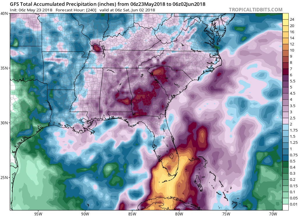
drezee wrote:Last Euro drops over 15 inches of rain over S Alabama. Yuck. Let's hope it doesn't stall.

Gonna be a slow mover. 15 inches could be conservative. If Euro verifies with a system moving inland across NOLA and then a meandering (some west drift) I think we could also see a heavy rainfall event over NOLA itself, with rains spreading more westward than might be currently thought after system comes ashore, and especially if we see a system onshore with little movement for an extended period of time. In that case the system might not be as lopsided toward the east as is currently expected. Pensacola to S Central La could really be under the gun for rainfall event.
1 likes   

Steve H.
Category 5
Category 5
Posts: 2134
Joined: Sat Oct 19, 2002 9:06 am
Location: Palm Bay, Florida

Re: ATL: INVEST 90L - Discussion: STWO- 0%-60%

#282 Postby Steve H. » Wed May 23, 2018 8:38 am

It does appear that the shear is lessening near the disturbance this morning in early IR loops. Let's see if it can respond with increased convection today.
0 likes   

User avatar
blp
Category 5
Category 5
Posts: 2805
Age: 45
Joined: Thu Sep 09, 2004 7:51 pm
Location: Miami, FL
Contact:

Re: ATL: INVEST 90L - Models

#283 Postby blp » Wed May 23, 2018 8:51 am

Still going to be a long waiting game. Models don't start consolidating a vorticity for another 72hrs. We might not know which solution will verify until then.
0 likes   
The following post is NOT an official forecast and should not be used as such. It is just the opinion of the poster and may or may not be backed by sound meteorological data. It is NOT endorsed by any professional institution including storm2k.org For Official Information please refer to the NHC and NWS products.

User avatar
tailgater
S2K Supporter
S2K Supporter
Posts: 3339
Joined: Sun Jul 11, 2004 9:13 pm
Location: St. Amant La.

Re: ATL: INVEST 90L - Discussion: STWO- 0%-60%

#284 Postby tailgater » Wed May 23, 2018 8:52 am

NDG wrote:
Dean4Storms wrote:Some 25kt winds to the WNW of the center along the coast of the Yucatan Peninsula. If this is an accurate representation of the surface wind field I see why NHC is going with 60% once this gets in the Gulf with time and lots of 80F SST's.

http://rammb.cira.colostate.edu/products/tc_realtime/image_mpsatwnd.asp?product=mpsatwnd&storm_identifier=AL902018&product_filename=2018AL90_MPSATWND_201805230900


The image is not correct, the surface low/trough appears to be right on the coast this morning. Cancun is now reporting east winds.

Image

Yeah looks even farther inland to me but definitely not well defined. Probably big time convection over the entire Yucatan peninsular later this evening.with daytime heating.
1 likes   
The following post is NOT an official forecast and should not be used as such. It is just the opinion of the poster and may or may not be backed by sound meteorological data. It is NOT endorsed by any professional institution including storm2k.org For Official Information please refer to the NHC and NWS products.

Aric Dunn
Category 5
Category 5
Posts: 21228
Age: 41
Joined: Sun Sep 19, 2004 9:58 pm
Location: Ready for the Chase.
Contact:

Re: ATL: INVEST 90L - Discussion: STWO- 0%-60%

#285 Postby Aric Dunn » Wed May 23, 2018 8:55 am

About time someone made it public they are discounting the GFS.. its off its rocker..
1 likes   
Note: If I make a post that is brief. Please refer back to previous posts for the analysis or reasoning. I do not re-write/qoute what my initial post said each time.
If there is nothing before... then just ask :)

Space & Atmospheric Physicist, Embry-Riddle Aeronautical University,
I believe the sky is falling...

User avatar
NDG
S2K Supporter
S2K Supporter
Posts: 14933
Joined: Sun Jul 09, 2006 10:14 pm
Location: Orlando, FL

Re: ATL: INVEST 90L - Models

#286 Postby NDG » Wed May 23, 2018 8:56 am

Latest GFS ensembles.

Image
0 likes   

User avatar
Steve
S2K Supporter
S2K Supporter
Posts: 8606
Joined: Sat Apr 05, 2003 11:41 pm
Location: Not a state-caster

Re: ATL: INVEST 90L - Models

#287 Postby Steve » Wed May 23, 2018 9:00 am

So basically, those GFS Ensembles are coming in line with what many of the other globals were saying yesterday. What was weird about the GFS all along was that it took the strongest piece of energy across Florida but re-consolidated everything in the larger swirl to around Destin. I think it was mistaking a piece of energy for the main center which was why it was determined to swing it out wide before pinwheeling everything back toward where the rest of the models said something was probably going to be.

Also noted is the slight left hook shown on each of those ensemble members at the end. Almost all of the models yesterday afternoon were showing this. And it's much more of a summer move than a late spring move. You see it in June (Cindy 2005) and sometimes later (Gustav 2008) where a system just wants to hook west rather than parabolically roll out north and northeast like most storms hitting the north Gulf do.
2 likes   

User avatar
gatorcane
S2K Supporter
S2K Supporter
Posts: 23499
Age: 46
Joined: Sun Mar 13, 2005 3:54 pm
Location: Boca Raton, FL

Re: ATL: INVEST 90L - Models

#288 Postby gatorcane » Wed May 23, 2018 9:06 am

GFS continues to insist the heaviest rains will be in Southern Florida next 10 days:

Image
0 likes   

User avatar
Steve
S2K Supporter
S2K Supporter
Posts: 8606
Joined: Sat Apr 05, 2003 11:41 pm
Location: Not a state-caster

Re: ATL: INVEST 90L - Discussion: STWO- 0%-60%

#289 Postby Steve » Wed May 23, 2018 9:07 am

Aric Dunn wrote:About time someone made it public they are discounting the GFS.. its off its rocker..


Yeah. I think I got what it was doing, but it should serve as an early reminder to people who live in area "x" not to go with the model that puts you at the biggest threat. Go with science and known biases in order to minimize getting fooled by emotion. As of now, the Panhandle looks to get smashed.
1 likes   

User avatar
NDG
S2K Supporter
S2K Supporter
Posts: 14933
Joined: Sun Jul 09, 2006 10:14 pm
Location: Orlando, FL

Re: ATL: INVEST 90L - Models

#290 Postby NDG » Wed May 23, 2018 9:11 am

The Euro's precip forecast is still almost completely the opposite to the GFS operational.

Image
1 likes   

User avatar
gatorcane
S2K Supporter
S2K Supporter
Posts: 23499
Age: 46
Joined: Sun Mar 13, 2005 3:54 pm
Location: Boca Raton, FL

Re: ATL: INVEST 90L - Discussion: STWO- 0%-60%

#291 Postby gatorcane » Wed May 23, 2018 9:12 am

Steve wrote:
Aric Dunn wrote:About time someone made it public they are discounting the GFS.. its off its rocker..


Yeah. I think I got what it was doing, but it should serve as an early reminder to people who live in area "x" not to go with the model that puts you at the biggest threat. Go with science and known biases in order to minimize getting fooled by emotion. As of now, the Panhandle looks to get smashed.


Regardless if model solution, it looks pretty clear some of the heaviest rainfalls will be over peninsular Florida because the weather will be mostly on the east side (and north side) of the system well away from the center not to mention as the system heads north in the Central or Eastern Gulf, it will start to expand and evolve into something more subtropical like a large comma where a continuous rainband could setup right over the FL peninsula not just the west coast of Florida. Even the CMC rainfall accumulation map shows a swath of significant rainfall for SE Florida despite it showing the system landfalling in Alabama.
Last edited by gatorcane on Wed May 23, 2018 9:13 am, edited 1 time in total.
1 likes   

User avatar
SouthFloridawx
S2K Supporter
S2K Supporter
Posts: 8344
Age: 45
Joined: Tue Jul 26, 2005 1:16 am
Location: Sarasota, FL
Contact:

Re: ATL: INVEST 90L - Discussion: STWO- 0%-60%

#292 Postby SouthFloridawx » Wed May 23, 2018 9:13 am

30 - 40 kts of Shear over the area currently. That's a lot of shear.
Image
0 likes   

Aric Dunn
Category 5
Category 5
Posts: 21228
Age: 41
Joined: Sun Sep 19, 2004 9:58 pm
Location: Ready for the Chase.
Contact:

Re: ATL: INVEST 90L - Models

#293 Postby Aric Dunn » Wed May 23, 2018 9:17 am

Yeah the GFS is lost and crying in a corner.. :P
0 likes   
Note: If I make a post that is brief. Please refer back to previous posts for the analysis or reasoning. I do not re-write/qoute what my initial post said each time.
If there is nothing before... then just ask :)

Space & Atmospheric Physicist, Embry-Riddle Aeronautical University,
I believe the sky is falling...

stormlover2013
Category 5
Category 5
Posts: 2312
Joined: Thu Aug 22, 2013 12:06 pm
Location: Lumberton, Texas

Re: ATL: INVEST 90L - Models

#294 Postby stormlover2013 » Wed May 23, 2018 9:23 am

Aric lol u better hope it is lol
1 likes   

Aric Dunn
Category 5
Category 5
Posts: 21228
Age: 41
Joined: Sun Sep 19, 2004 9:58 pm
Location: Ready for the Chase.
Contact:

Re: ATL: INVEST 90L - Discussion: STWO- 0%-60%

#295 Postby Aric Dunn » Wed May 23, 2018 9:23 am

SouthFloridawx wrote:30 - 40 kts of Shear over the area currently. That's a lot of shear.
Image


yep, eventually, that shear will help get convection going and help develop the system overall. later on, the shear will turn out of the SSW to S and become divergent... to what extent the shear will have on center reformations will determine how fast the system reaches the coast. if center reformations are minimal, then a slower progress to the coast and higher chance it will meander offshore for a while. More reformations mean it will likely be inland before it begins to meander around.
1 likes   
Note: If I make a post that is brief. Please refer back to previous posts for the analysis or reasoning. I do not re-write/qoute what my initial post said each time.
If there is nothing before... then just ask :)

Space & Atmospheric Physicist, Embry-Riddle Aeronautical University,
I believe the sky is falling...

User avatar
gatorcane
S2K Supporter
S2K Supporter
Posts: 23499
Age: 46
Joined: Sun Mar 13, 2005 3:54 pm
Location: Boca Raton, FL

Re: ATL: INVEST 90L - Models

#296 Postby gatorcane » Wed May 23, 2018 9:27 am

I am finding a hard time seeing how the GFS is going to completely bust here when looking at the shear map at 72 hours. How is anything going to consolidate in the Central GOM like the ECMWF shows with that shear? Situation reminds me a bit of Hermine in 2016 when it was east of the Bahamas heading west. ECMWF said CAT 1 into South Florida just a 4-5 days out but the GFS said nope an upper low was going to develop in the Bahamas and prevent any development. GFS was right on with this one and Hermine was nothing but a naked swirl passing through the FL straits:

Image

Image
1 likes   

stormreader
Category 5
Category 5
Posts: 1242
Joined: Fri Jun 24, 2011 10:58 am

Re: ATL: INVEST 90L - Models

#297 Postby stormreader » Wed May 23, 2018 9:38 am

gatorcane wrote:I am finding a hard time seeing how the GFS is going to completely bust here when looking at the shear map at 72 hours. How is anything going to consolidate in the Central GOM like the ECMWF shows with that shear? Situation reminds me a bit of Hermine in 2016 when it was east of the Bahamas heading west. ECMWF said CAT 1 into South Florida just a 4-5 days out but the GFS said nope an upper low was going to develop in the Bahamas and prevent any development. GFS was right on with this one and Hermine was nothing but a naked swirl passing through the FL straits:

Image

Image

Understand your point about consolidation and a possible organized tropical system be less likely further west. Its an academic argument that should definitely be addressed on the board. But rainfall is the imminent threat. And the Euro could very well be correct about "landfall", but you may be correct that it turns out to mostly be a sloppy rainmaker. Still have to see how the system stalls or drifts along the coast to see how rain pans out, but seems hard to get away from the Pensacola-Mobile area as being seriously under the gun for rain (Euro forecast) and quite possibly NOLA and somewhat further west if we get a west meandering slightly inland.
0 likes   

User avatar
toad strangler
S2K Supporter
S2K Supporter
Posts: 4162
Joined: Sun Jul 28, 2013 3:09 pm
Location: Earth
Contact:

Re: ATL: INVEST 90L - Models

#298 Postby toad strangler » Wed May 23, 2018 9:41 am

Aric Dunn wrote:Yeah the GFS is lost and crying in a corner.. :P


The GFS has climo on it's side. Does that make it correct? Of course not but climo has to be factored in especially with the forecasted shear ....
0 likes   

caneman
Category 5
Category 5
Posts: 1178
Joined: Fri Sep 05, 2014 5:44 am
Location: Clearwater Beach, Fl

Re: ATL: INVEST 90L - Discussion: STWO- 0%-60%

#299 Postby caneman » Wed May 23, 2018 9:42 am

Aric Dunn wrote:About time someone made it public they are discounting the GFS.. its off its rocker..


I am not going with any model pre system development
We won't know til the end game. Anyone claiming one has performed better than another or will perform better when nothing has actually developed should know better. The only concern right now is the massive amount of rain especially if it targets those inundated already.
1 likes   

User avatar
SFLcane
S2K Supporter
S2K Supporter
Posts: 9606
Age: 46
Joined: Sat Jun 05, 2010 1:44 pm
Location: Lake Worth Florida

Re: ATL: INVEST 90L - Models

#300 Postby SFLcane » Wed May 23, 2018 9:43 am

I'am with gatorcane and find any well stacked low in the gulf highly suspect. Environment just looks awful. lol GFS 10+ inches across SFL EURO 2-4
0 likes   


Return to “2018”

Who is online

Users browsing this forum: No registered users and 96 guests