ATL: ALBERTO - Post-Tropical
Moderator: S2k Moderators
Re: ATL: ALBERTO - Sub-Tropical Storm
Traveling down the West coast of Florida tomorrow night dont want any surprises
0 likes
-
Aric Dunn
- Category 5

- Posts: 21228
- Age: 41
- Joined: Sun Sep 19, 2004 9:58 pm
- Location: Ready for the Chase.
- Contact:
Re: ATL: ALBERTO - Sub-Tropical Storm
THe southerly upper level winds have already begun to really spread over the circulation. only a short matter of time before the llc either starts moving north trying to catch the convection or we get a reformation. no signs of a reformation at the moment though.
or we see convection build with the llc and the other convection just gets sheared off..
or we see convection build with the llc and the other convection just gets sheared off..
0 likes
Note: If I make a post that is brief. Please refer back to previous posts for the analysis or reasoning. I do not re-write/qoute what my initial post said each time.
If there is nothing before... then just ask
Space & Atmospheric Physicist, Embry-Riddle Aeronautical University,
I believe the sky is falling...
If there is nothing before... then just ask
Space & Atmospheric Physicist, Embry-Riddle Aeronautical University,
I believe the sky is falling...
-
Wx_Warrior
- Category 5
- Posts: 2718
- Joined: Thu Aug 03, 2006 3:58 pm
- Location: Beaumont, TX

Re: ATL: ALBERTO - Models
ROCK wrote:Frank P wrote:The GFS is now basically where the Euro was aiming at consistently several days ago... and although the last day of Euro runs were a slight shift towards the MS/AL line... gotta give the Euro cudos for at least being in the same ballpark all week long... thus far...
Euro has been WAY more consistent than the jacked up GFS of late. Yep kudos..
Dont think anyone is really taking the GFS seriously. The UKMET run I would trust more. Models look to now be settled on North Gulf coast. Good for us in west Florida
1 likes
Re: ATL: ALBERTO - Models
Evil Jeremy wrote:12z UKMET shifted west, but not significantly, and remains the eastern outlier.
Looks like both the UKMET and CMC, eastern outliers, both take Alberto over the western tip of Cuba... will have to see if that pans out and will be easy enough to confirm in the next day... GFS and Euro go thru the channel between Cuba and the Yucatan...
0 likes

Re: ATL: ALBERTO - Models
can someone please post the ukmet run or provide a link please? 
0 likes
Robbielyn McCrary
I know just about enough to sound like I know what I'm talking about sometimes. But for your safety please follow the nhc for truly professional forecasting.
I know just about enough to sound like I know what I'm talking about sometimes. But for your safety please follow the nhc for truly professional forecasting.

Re: ATL: ALBERTO - Models
NHC taking this over the LC which is mighty warm this time of year. Keeping a high end TS seems logical but wouldn't rule out a Cat 1 if shear lets up some.JMO
1 likes
-
Evil Jeremy

- S2K Supporter

- Posts: 5459
- Age: 30
- Joined: Mon Apr 10, 2006 2:10 pm
- Location: Los Angeles, CA
Re: ATL: ALBERTO - Models
Latest UKMET track can be found on the SFWMD plot. No idea on intensity.
https://my.sfwmd.gov/sfwmd/common/image ... s/storm_01
https://my.sfwmd.gov/sfwmd/common/image ... s/storm_01
1 likes
Frances 04 / Jeanne 04 / Katrina 05 / Wilma 05 / Fay 08 / Debby 12 / Andrea 13 / Colin 16 / Hermine 16 / Matthew 16 / Irma 17
-
SunnyThoughts
- Category 5
- Posts: 2263
- Joined: Wed Jul 09, 2003 12:42 pm
- Location: Pensacola, Florida
-
AtlanticWind

- S2K Supporter
- Posts: 1805
- Age: 65
- Joined: Sun Aug 08, 2004 9:57 pm
- Location: Plantation,Fla
-
tolakram
- Admin

- Posts: 19165
- Age: 60
- Joined: Sun Aug 27, 2006 8:23 pm
- Location: Florence, KY (name is Mark)
Re: ATL: ALBERTO - Models
Reminder everyone, this is the models thread not the discussion thread.
If your post doesn't add to the conversation, here in the models thread, it will probably be removed. We welcome discussion about model runs but one liners, especially one liners that bash a model, will not be tolerated. I think it's also a good time to remind everyone to be respectful of everyone else, regardless of the color of your name.
Thanks for your cooperation.
5 likes
M a r k
- - - - -
Join us in chat: Storm2K Chatroom Invite. Android and IOS apps also available.
The posts in this forum are NOT official forecasts and should not be used as such. Posts are NOT endorsed by any professional institution or STORM2K.org. For official information and forecasts, please refer to NHC and NWS products.
-
gatorcane

- S2K Supporter
- Posts: 23499
- Age: 46
- Joined: Sun Mar 13, 2005 3:54 pm
- Location: Boca Raton, FL
Re: ATL: ALBERTO - Models
The 12Z UKMET didn't move much as Evil Jeremy pointed out, another image:

0 likes

Re: ATL: ALBERTO - Models
12z CMC also shifted a little west from previous 0z run, for what ever is worth.
0 likes
-
gatorcane
- S2K Supporter
- Posts: 23499
- Age: 46
- Joined: Sun Mar 13, 2005 3:54 pm
- Location: Boca Raton, FL
Re: ATL: ALBERTO - Models
AtlanticWind wrote:GFS FV3 Takes storm very near SW florida coast
Yep, same as the UKMET, saved image of GFS FV3:
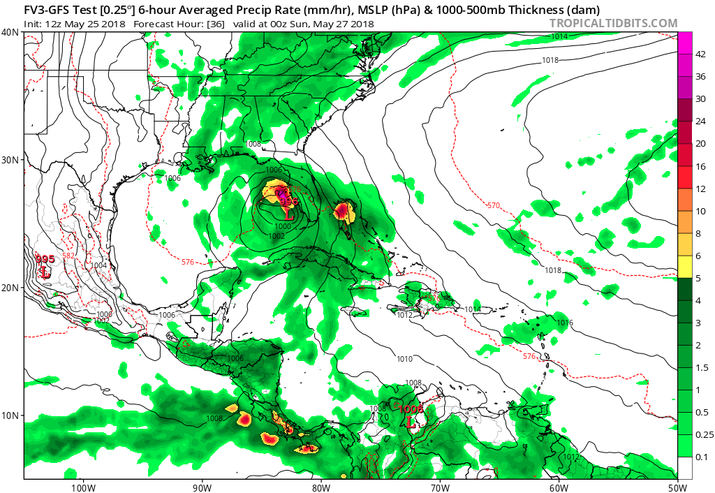
0 likes
-
gatorcane
- S2K Supporter
- Posts: 23499
- Age: 46
- Joined: Sun Mar 13, 2005 3:54 pm
- Location: Boca Raton, FL
Re: ATL: ALBERTO - Sub-Tropical Storm
certainly looks like the center may be trying to form under convection to the NE. The GFS FV3 and UKMET show a more NE track to the Western tip of Cuba in this type of scenario.
http://rammb.cira.colostate.edu/ramsdis ... display=12
http://rammb.cira.colostate.edu/ramsdis ... display=12
1 likes
-
Aric Dunn
- Category 5
- Posts: 21228
- Age: 41
- Joined: Sun Sep 19, 2004 9:58 pm
- Location: Ready for the Chase.
- Contact:
Re: ATL: ALBERTO - Sub-Tropical Storm
With systems like this. always watch the seabreezes. they can kill a weak circ and can also help jump start.. look at the seabreeze moving inland from the north coast... it might help spin up another vort of llc offshore the in the gulf.
0 likes
Note: If I make a post that is brief. Please refer back to previous posts for the analysis or reasoning. I do not re-write/qoute what my initial post said each time.
If there is nothing before... then just ask
Space & Atmospheric Physicist, Embry-Riddle Aeronautical University,
I believe the sky is falling...
If there is nothing before... then just ask
Space & Atmospheric Physicist, Embry-Riddle Aeronautical University,
I believe the sky is falling...
-
PSUHiker31
- Tropical Storm

- Posts: 114
- Joined: Tue Oct 03, 2017 2:36 pm
Re: ATL: ALBERTO - Models
I just don't like that double low the GFS is showing while it is in the central Gulf. It is pretty clear that the model is still having feedback issues and it is affecting the projection for Alberto
0 likes
-
stormreader
- Category 5
- Posts: 1242
- Joined: Fri Jun 24, 2011 10:58 am
Re: ATL: ALBERTO - Models
NDG wrote:Another westward shift by the GFS, now just south of the mouth of the MS River by hr 66.
A long way from Tampa and Fl west coast, isn’t it? Lol. Th east bias gets really tiresome. Seems like it’s only real purpose is as a slight modification for the Euro forecast, and then only if joined by other models.
0 likes
-
SunnyThoughts
- Category 5
- Posts: 2263
- Joined: Wed Jul 09, 2003 12:42 pm
- Location: Pensacola, Florida
Re: ATL: ALBERTO - Sub-Tropical Storm
Definitely curious to see recon observations to try and pinpoint where LLC and MLC are at this time. Should be wheels up shortly.
1 likes
Who is online
Users browsing this forum: No registered users and 100 guests