ATL: ALBERTO - Post-Tropical
Moderator: S2k Moderators
-
gatorcane

- S2K Supporter

- Posts: 23499
- Age: 46
- Joined: Sun Mar 13, 2005 3:54 pm
- Location: Boca Raton, FL
Re: ATL: INVEST 90L - Models
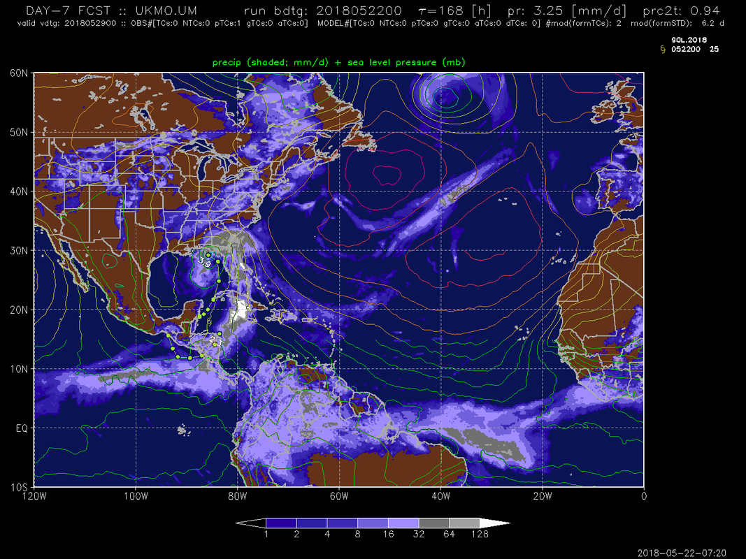
00Z UKMET shifts east and gets closer to the west coast of Florida. The right side has all the weather (even well east of the center as the image shows below) so peninsula FL would get a good soaking from this:
2 likes
-
Miami Storm Tracker

- Category 3

- Posts: 893
- Age: 66
- Joined: Sun Jun 13, 2010 10:12 pm
- Location: Key Largo, Fla.
- Contact:
Re: ATL: INVEST 90L - Discussion
Good morning everyone,
Maybe one of the Pro Met's can chime in on my question. What are the chances a new low forms under all the convection blowing up east of the current low.
Maybe one of the Pro Met's can chime in on my question. What are the chances a new low forms under all the convection blowing up east of the current low.
1 likes
-
gatorcane
- S2K Supporter
- Posts: 23499
- Age: 46
- Joined: Sun Mar 13, 2005 3:54 pm
- Location: Boca Raton, FL
Re: ATL: INVEST 90L - Discussion
Miami Storm Tracker wrote:Good morning everyone,
Maybe one of the Pro Met's can chime in on my question. What are the chances a new low forms under all the convection blowing up east of the current low.
That's basically what the GFS insists will happen.
1 likes
-
Aric Dunn
- Category 5

- Posts: 21228
- Age: 41
- Joined: Sun Sep 19, 2004 9:58 pm
- Location: Ready for the Chase.
- Contact:
Re: ATL: INVEST 90L - Discussion
well we have a fairly well established weak circulation east of belize. at least the models got that right. lol
0 likes
Note: If I make a post that is brief. Please refer back to previous posts for the analysis or reasoning. I do not re-write/qoute what my initial post said each time.
If there is nothing before... then just ask
Space & Atmospheric Physicist, Embry-Riddle Aeronautical University,
I believe the sky is falling...
If there is nothing before... then just ask
Space & Atmospheric Physicist, Embry-Riddle Aeronautical University,
I believe the sky is falling...
-
cycloneye

- Admin

- Posts: 139028
- Age: 67
- Joined: Thu Oct 10, 2002 10:54 am
- Location: San Juan, Puerto Rico
Re: ATL: INVEST 90L - Models
cycloneye wrote:12z SHIP output:Code: Select all
          * ATLANTIC     SHIPS INTENSITY FORECAST          *
                    * IR SAT DATA PROXY USED,      OHC AVAILABLE     *
                    *  INVEST      AL902018  05/22/18  12 UTC        *

TIME (HR)          0     6    12    18    24    36    48    60    72    84    96   108   120
V (KT) NO LAND    25    26    26    27    27    29    30    35    36    40    44    47    52
V (KT) LAND       25    26    26    27    27    28    29    34    31    29    34    37    42
V (KT) LGEM       25    25    24    24    23    23    25    25    23    25    28    28    30
Storm Type      TROP  TROP  TROP  TROP  TROP  TROP  TROP  TROP  TROP  TROP  TROP  TROP  TROP

SHEAR (KT)        26    24    25    24    21    20    14    15    18    17    16    19    23
SHEAR ADJ (KT)     2     2     1     0     2     2     0     0    -4    -6    -4     0    -3
SHEAR DIR        284   275   266   275   276   263   282   237   248   239   255   271   282
SST (C)         28.8  29.0  29.1  29.2  29.3  29.3  29.1  29.0  28.9  28.8  28.6  28.2  28.1
POT. INT. (KT)   147   149   150   151   152   153   150   149   147   147   145   141   141
ADJ. POT. INT.   136   135   135   135   136   138   136   138   135   138   139   137   137
200 MB T (C)   -54.0 -53.7 -53.3 -53.4 -53.6 -53.1 -53.5 -52.9 -53.3 -52.6 -53.1 -52.6 -53.3
200 MB VXT (C)   0.2   0.3   0.5   0.4   0.4   0.3   0.3   0.6   0.4   0.5   0.3   0.3   0.2
TH_E DEV (C)       8    10    11     9     8    10     8    10     8     9     7     9     9
700-500 MB RH     58    55    60    60    59    63    63    66    69    71    69    70    66
MODEL VTX (KT)     6     6     6     6     5     6     5     7     7     9    10    10    13
850 MB ENV VOR    59    54    54    56    45    48    44    70    84   101    86    69    42
200 MB DIV        44    37    29    33    32    46    29    58    67    81    74    66    47
700-850 TADV      -2     0     0    -1    -2     0     0    -2     0     1     1     7    16
LAND (KM)        107    63    31    10     0     0    71    45   -16   -16    78   346    80
LAT (DEG N)     17.5  17.4  17.3  17.2  17.1  17.1  16.7  16.2  15.6  15.7  16.5  18.4  21.1
LONG(DEG W)     87.1  87.6  87.9  88.1  88.2  88.2  87.6  87.1  86.4  85.5  84.1  82.4  80.4
STM SPEED (KT)     6     4     3     2     1     2     3     4     3     7    10    14    18
HEAT CONTENT      40    39    39    29    20    20    45    44    55    54    33    47    37

  FORECAST TRACK FROM TABM      INITIAL HEADING/SPEED (DEG/KT):270/  8      CX,CY:  -7/  0
  T-12 MAX WIND:  25            PRESSURE OF STEERING LEVEL (MB):  758  (MEAN=618)
  GOES IR BRIGHTNESS TEMP. STD DEV.  50-200 KM RAD:  20.7 (MEAN=14.5)
  % GOES IR PIXELS WITH T < -20 C    50-200 KM RAD:  38.0 (MEAN=65.0)
  PRELIM RI PROB (DV .GE. 55 KT IN 48 HR):            0.1

                        INDIVIDUAL CONTRIBUTIONS TO INTENSITY CHANGE
                         6   12   18   24   36   48   60   72   84   96  108  120
                        ----------------------------------------------------------
  SAMPLE MEAN CHANGE     1.   2.   3.   4.   6.   8.   9.  10.  11.  12.  13.  13.
  SST POTENTIAL          0.   1.   1.   3.   6.  11.  17.  22.  26.  30.  32.  35.
  VERTICAL SHEAR MAG     1.   1.   1.   1.   0.  -1.  -3.  -4.  -6.  -7.  -8. -10.
  VERTICAL SHEAR ADJ    -0.  -0.  -0.  -0.  -0.  -1.  -0.   0.   2.   3.   3.   3.
  VERTICAL SHEAR DIR    -0.  -1.  -1.  -1.  -2.  -3.  -5.  -7.  -9. -10. -11. -12.
  PERSISTENCE           -0.  -1.  -1.  -1.  -1.  -1.  -1.  -1.  -0.   0.   0.   1.
  200/250 MB TEMP.      -0.  -0.  -0.  -0.  -1.  -1.  -1.  -1.  -1.  -1.  -2.  -2.
  THETA_E EXCESS         0.   0.   0.   0.   0.   0.   0.   0.   0.   0.   0.   0.
  700-500 MB RH         -0.  -0.  -0.  -0.  -1.  -1.  -2.  -3.  -4.  -4.  -4.  -4.
  MODEL VTX TENDENCY    -0.  -0.  -1.  -2.  -2.  -4.  -2.  -3.  -2.  -1.  -1.   2.
  850 MB ENV VORTICITY   0.   0.   0.   0.   1.   1.   1.   1.   2.   3.   3.   3.
  200 MB DIVERGENCE      0.   0.   0.   0.   0.   0.   0.   0.   1.   1.   0.  -1.
  850-700 T ADVEC        0.  -0.  -0.  -0.  -0.  -0.  -0.  -1.  -1.  -1.  -0.  -0.
  ZONAL STORM MOTION    -0.   0.   0.   0.   1.   1.   1.   1.   1.   1.   1.   1.
  STEERING LEVEL PRES   -0.  -0.  -0.  -1.  -1.  -1.  -1.  -2.  -2.  -2.  -2.  -2.
  DAYS FROM CLIM. PEAK   0.   0.   0.   0.   0.   0.   1.   1.   1.   2.   2.   2.
  GOES PREDICTORS       -0.  -1.  -1.  -1.  -2.  -3.  -3.  -4.  -3.  -3.  -2.  -2.
  OCEAN HEAT CONTENT    -0.  -0.  -0.  -0.  -0.  -1.  -1.  -1.  -1.  -1.  -1.  -0.
                        ----------------------------------------------------------
  TOTAL CHANGE           1.   1.   2.   2.   4.   5.  10.  11.  15.  19.  22.  27.

                CURRENT MAX WIND (KT):   25. LAT, LON:   17.5    87.1

      ** 2017 ATLANTIC RI INDEX AL902018 INVEST     05/22/18  12 UTC **
 (SHIPS-RII PREDICTOR TABLE for 30 KT OR MORE MAXIMUM WIND INCREASE IN NEXT 24-h)

     Predictor             Value   RI Predictor Range  Scaled Value(0-1) % Contribution
 12 HR PERSISTENCE (KT):     0.0     -49.5  to   33.0       0.60         999.0
 850-200 MB SHEAR (KT) :    24.0      30.1  to    2.9       0.22         999.0
 HEAT CONTENT (KJ/cm2) :    33.4       0.0  to  156.2       0.21         999.0
 2nd PC OF IR BR TEMP  :  9999.0       2.4  to   -3.0     999.00         999.0
 STD DEV OF IR BR TEMP :   999.0      36.6  to    2.8     999.00         999.0
 MAXIMUM WIND (kt)     :    25.0      22.5  to  121.0       0.07         999.0
 POT = MPI-VMAX (KT)   :   110.3      28.4  to  139.6       0.74         999.0
 D200 (10**7s-1)       :    35.0     -29.7  to  181.5       0.31         999.0
 BL DRY-AIR FLUX (w/m2):   110.4     961.4  to  -67.1       0.83         999.0
 % AREA WITH TPW <45 mm:    34.5     100.0  to    0.0       0.65         999.0

 SHIPS Prob RI for 20kt/ 12hr RI threshold= 999% is 999.0 times sample mean ( 5.4%)
 SHIPS Prob RI for 25kt/ 24hr RI threshold= 999% is 999.0 times sample mean (11.5%)
 SHIPS Prob RI for 30kt/ 24hr RI threshold= 999% is 999.0 times sample mean ( 7.4%)
 SHIPS Prob RI for 35kt/ 24hr RI threshold= 999% is 999.0 times sample mean ( 4.3%)
 SHIPS Prob RI for 40kt/ 24hr RI threshold= 999% is 999.0 times sample mean ( 2.8%)
 SHIPS Prob RI for 45kt/ 36hr RI threshold= 999% is 999.0 times sample mean ( 5.1%)
 SHIPS Prob RI for 55kt/ 48hr RI threshold= 999% is 999.0 times sample mean ( 5.3%)
 SHIPS Prob RI for 65kt/ 72hr RI threshold= 999% is 999.0 times sample mean ( 6.0%)

Matrix of RI probabilities
------------------------------------------------------------------------------
  RI (kt / h)  | 20/12 | 25/24 | 30/24 | 35/24 | 40/24 | 45/36 | 55/48  |65/72
------------------------------------------------------------------------------
   SHIPS-RII:   999.0%  999.0%  999.0%  999.0%  999.0%  999.0%  999.0%  999.0%
    Logistic:   999.0%  999.0%  999.0%  999.0%  999.0%  999.0%  999.0%  999.0%
    Bayesian:   999.0%  999.0%  999.0%  999.0%  999.0%  999.0%  999.0%  999.0%
   Consensus:   999.0%  999.0%  999.0%  999.0%  999.0%  999.0%  999.0%  999.0%

   ##         ANNULAR HURRICANE INDEX (AHI) AL902018 INVEST     05/22/18  12 UTC         ##
   ##         ERR=2, BOTH IR FILES BAD OR MISSING

** PROBLTY OF AT LEAST 1 SCNDRY EYEWL FORMTN EVENT AL902018 INVEST     05/22/2018  12 UTC **
TIME(HR)   0-12  12-24(0-24)  24-36(0-36)  36-48(0-48)
CLIMO(%)     0      0(  0)       0(  0)       0(  0)     <-- PROB BASED ON INTENSITY ONLY
PROB(%)      0      0(  0)       0(  0)       0(  0)     PC4 UNAVAIL...MODEL SKILL DEGRADED

** DSHIPS INTENSITY FORECAST ADJUSTED RELATIVE TO ONSET OF ERC WEAKENING PHASE **
      TIME (HR)      0     6    12    18    24    36    48    60    72    84    96   108   120
>24HR AGO (DSHIPS)  25    26    26    27    27    28    29    34    31    29    34    37    42
 18HR AGO           25    24    24    25    25    26    27    32    29    27    32    35    40
 12HR AGO           25    22    21    22    22    23    24    29    26    24    29    32    37
  6HR AGO           25    19    16    15    15   DIS   DIS   DIS   DIS   DIS   DIS   DIS   DIS
      NOW                              CURRENT INTENSITY < 83 KT
  IN  6HR                              INTENSITY IN  6HR < 83 KT
  IN 12HR                              INTENSITY IN 12HR < 83 KT
Graphic of the 12z SHIP output shows is more bullish.

1 likes
Visit the Caribbean-Central America Weather Thread where you can find at first post web cams,radars
and observations from Caribbean basin members Click Here
and observations from Caribbean basin members Click Here
-
wxman57

- Moderator-Pro Met

- Posts: 22480
- Age: 66
- Joined: Sat Jun 21, 2003 8:06 pm
- Location: Houston, TX (southwest)
Re: ATL: INVEST 90L - Discussion
GFS ensembles are saying Apalachicola for "landfall". EC ensembles centered on Mobile Bay. Somewhere between the two is most likely. Florida panhandle. However, I don't expect any TS winds west of the center or inland. any TS winds will be off the west coast of Florida and out over the water south of the Panhandle. This is a rain event onshore.
5 likes
-
Aric Dunn
- Category 5
- Posts: 21228
- Age: 41
- Joined: Sun Sep 19, 2004 9:58 pm
- Location: Ready for the Chase.
- Contact:
Re: ATL: INVEST 90L - Discussion: STWO-0%-40%- Cone more to the right
robbielyn wrote:northjaxpro wrote:Well, this is an indication with the yellow circle now shifting east that the NHC is putting more weight to what the GFS has long been persisting all along. An Eastern Gulf solution or N/NNE motion potential solution looks reasonable.
Wxman57 said as much. Seems NHC agrees with him. I am so glad we have knowledgeable mets on here. I love this forum. I already see a lot of convection on the east side of the low. Regardless of landfall if any, we will see tons of rain.
The NHC will always do a blend of the models......
0 likes
Note: If I make a post that is brief. Please refer back to previous posts for the analysis or reasoning. I do not re-write/qoute what my initial post said each time.
If there is nothing before... then just ask
Space & Atmospheric Physicist, Embry-Riddle Aeronautical University,
I believe the sky is falling...
If there is nothing before... then just ask
Space & Atmospheric Physicist, Embry-Riddle Aeronautical University,
I believe the sky is falling...

Re: ATL: INVEST 90L - Discussion
What kind of weather will SE Florida get from this a heavy rain event or just a few showers from the outskirts of this system.
0 likes
-
Miami Storm Tracker
- Category 3
- Posts: 893
- Age: 66
- Joined: Sun Jun 13, 2010 10:12 pm
- Location: Key Largo, Fla.
- Contact:
Re: ATL: INVEST 90L - Discussion
Thanks for all the thoughts on my question, Boca I was wondering the same thing how much rain are we looking at.
0 likes
-
Aric Dunn
- Category 5
- Posts: 21228
- Age: 41
- Joined: Sun Sep 19, 2004 9:58 pm
- Location: Ready for the Chase.
- Contact:
Re: ATL: INVEST 90L - Discussion
It is the development of this low/vorticity over southern Alabama that drives 90l to the NE. Without this feature ( which the GFS has had in some form or the other on every run) the GFS would undoubtedly be similar to the rest of the models with a northward motion accelerated by multiple center relocation from the ssw shear which acts to accelerate to the north. If the shear were to be slightly lighter this effect may not happen for it would be less dramatic and landfall would be later and farther west.
however, given the current location and set up the gfs is the outlier and each run adjusts for the current analysis then quickly goes to left field. Euro/cmc/icon blend is much more likely.

however, given the current location and set up the gfs is the outlier and each run adjusts for the current analysis then quickly goes to left field. Euro/cmc/icon blend is much more likely.
Last edited by Aric Dunn on Tue May 22, 2018 8:35 am, edited 1 time in total.
1 likes
Note: If I make a post that is brief. Please refer back to previous posts for the analysis or reasoning. I do not re-write/qoute what my initial post said each time.
If there is nothing before... then just ask
Space & Atmospheric Physicist, Embry-Riddle Aeronautical University,
I believe the sky is falling...
If there is nothing before... then just ask
Space & Atmospheric Physicist, Embry-Riddle Aeronautical University,
I believe the sky is falling...
-
chris_fit

- Category 5
- Posts: 3078
- Joined: Wed Sep 10, 2003 11:58 pm
- Location: Tampa Bay Area, FL
- Contact:
Re: ATL: INVEST 90L - Discussion
wxman57 wrote:GFS ensembles are saying Apalachicola for "landfall". EC ensembles centered on Mobile Bay. Somewhere between the two is most likely. Florida panhandle. However, I don't expect any TS winds west of the center or inland. any TS winds will be off the west coast of Florida and out over the water south of the Panhandle. This is a rain event onshore.
What are you thinking as for as rainfall accumulation for the peninsula?
0 likes
-
wxman57
- Moderator-Pro Met
- Posts: 22480
- Age: 66
- Joined: Sat Jun 21, 2003 8:06 pm
- Location: Houston, TX (southwest)
Re: ATL: INVEST 90L - Discussion
Miami Storm Tracker wrote:Good morning everyone,
Maybe one of the Pro Met's can chime in on my question. What are the chances a new low forms under all the convection blowing up east of the current low.
I've been forecasting hurricanes for nearly 4 decades now, and one thing I've learned (over and over) is that the center will follow the convection. In a higher wind shear environment, follow the convection, not the weak swirl upwind. This disturbance and setup has reminded me of 2012's Debby from the start. Same environment, same appearance. Back then, the Euro was forecasting Debby to turn west with the low-level flow and impact Texas as a hurricane. The GFS was the outlier, taking a sheared TS into northern Florida. The NHC (and us) had a westerly track. Then, overnight, the EC shifted to Florida. The NHC didn't want to shift the track all at once to Florida, so they indicated a hurricane striking New Orleans on one advisory (causing a panic there). Next advisory, the track was into the eastern Florida panhandle. The GFS was right. All the other models incorrectly moved it with the lower-level flow.
The moral of the story is to follow the convection. Where the convection goes (or is sheared off), the center will follow/reform.
I had saved some satellite imagery of Debby (below). Notice any similarities at all?


13 likes
-
Miami Storm Tracker
- Category 3
- Posts: 893
- Age: 66
- Joined: Sun Jun 13, 2010 10:12 pm
- Location: Key Largo, Fla.
- Contact:
Re: ATL: INVEST 90L - Discussion
As always great information from WXman57, thanks for posting the shots if you did not know better you would think they were sat pics of the current 90 L.
1 likes

Re: ATL: INVEST 90L - Discussion
As I recall, TS Debbie caused extreme flooding in North and Central Florida.
If this track resolves, similar conditions may occur.
Might wash out our annual camping trip to the Springs. (literally)
If this track resolves, similar conditions may occur.
Might wash out our annual camping trip to the Springs. (literally)
0 likes
-
Aric Dunn
- Category 5
- Posts: 21228
- Age: 41
- Joined: Sun Sep 19, 2004 9:58 pm
- Location: Ready for the Chase.
- Contact:
Re: ATL: INVEST 90L - Discussion
wxman57 wrote:Miami Storm Tracker wrote:Good morning everyone,
Maybe one of the Pro Met's can chime in on my question. What are the chances a new low forms under all the convection blowing up east of the current low.
I've been forecasting hurricanes for nearly 4 decades now, and one thing I've learned (over and over) is that the center will follow the convection. In a higher wind shear environment, follow the convection, not the weak swirl upwind. This disturbance and setup has reminded me of 2012's Debby from the start. Same environment, same appearance. Back then, the Euro was forecasting Debby to turn west with the low-level flow and impact Texas as a hurricane. The GFS was the outlier, taking a sheared TS into northern Florida. The NHC (and us) had a westerly track. Then, overnight, the EC shifted to Florida. The NHC didn't want to shift the track all at once to Florida, so they indicated a hurricane striking New Orleans on one advisory (causing a panic there). Next advisory, the track was into the eastern Florida panhandle. The GFS was right. All the other models incorrectly moved it with the lower-level flow.
The moral of the story is to follow the convection. Where the convection goes (or is sheared off), the center will follow/reform.
I had saved some satellite imagery of Debby (below). Notice any similarities at all?You could pass that first image off as the current satellite image of 90L.
Agreed as to always follow the convection in sheared environments. however, debbie had a large ridge to its north ( hence the westward motion from the other models). FOr 90l we have strong ridging to the east. This ridging will limit the extent of eastward propagation of center reformations. The GFS also, in this case, is not the same set up as debbie. The last endless runs of the GFS have not only shear driven motion as it was with debbie. the GFS, in this case, has the main driving force of a low/vorticity sitting over southern Alabama( 00z and 6z other runs had it in various other places). Also even from the GFS the shear axis becomes more SSW to even south as 90l move north of the upper trough so in this case the GFS also would be moving north if it were not for the low along the northern gulf coast.
it remains to be seen if any sort of low is there in 3 to 5 days time. there is one there currently but the gfs weakens the current low and develops another is the same spot.. who knows.. but right now the GFS is the outlier for more reasons than just the shear directing center reformation associated with convection.
1 likes
Note: If I make a post that is brief. Please refer back to previous posts for the analysis or reasoning. I do not re-write/qoute what my initial post said each time.
If there is nothing before... then just ask
Space & Atmospheric Physicist, Embry-Riddle Aeronautical University,
I believe the sky is falling...
If there is nothing before... then just ask
Space & Atmospheric Physicist, Embry-Riddle Aeronautical University,
I believe the sky is falling...

Re: ATL: INVEST 90L - Models
Quite the spread so far in track projections (click on storm 90 at top). 00z UKMET seems to be in the center now.
https://www.sfwmd.gov/weather-radar/hurricane-model-plots
https://www.sfwmd.gov/weather-radar/hurricane-model-plots
2 likes
-
northjaxpro

- S2K Supporter
- Posts: 8900
- Joined: Mon Sep 27, 2010 11:21 am
- Location: Jacksonville, FL
Re: ATL: INVEST 90L - Discussion
jdjaguar wrote:As I recall, TS Debbie caused extreme flooding in North and Central Florida.
If this track resolves, similar conditions may occur.
Might wash out our annual camping trip to the Springs. (literally)
I measured over 16 inches of rainfall at my locale during Debby in 2012. Many atras in North and Central Florida had extensive flooding.
Last edited by northjaxpro on Tue May 22, 2018 9:23 am, edited 1 time in total.
1 likes
NEVER, EVER SAY NEVER in the tropics and weather in general, and most importantly, with life itself!!
________________________________________________________________________________________
Fay 2008 Beryl 2012 Debby 2012 Colin 2016 Hermine 2016 Julia 2016 Matthew 2016 Irma 2017 Dorian 2019
________________________________________________________________________________________
Fay 2008 Beryl 2012 Debby 2012 Colin 2016 Hermine 2016 Julia 2016 Matthew 2016 Irma 2017 Dorian 2019
Re: ATL: INVEST 90L - Discussion
jdjaguar wrote:As I recall, TS Debbie caused extreme flooding in North and Central Florida.
If this track resolves, similar conditions may occur.
Might wash out our annual camping trip to the Springs. (literally)
That is correct. We were absolutely hammered by rain in Clearwater. Went on a cruise and the weather and wind with it was enough to feel Debbys effects al the way down to Cozumel and Cayman. With high winds and rough seas. She was no joke.
1 likes
-
crownweather

- S2K Supporter
- Posts: 575
- Age: 49
- Joined: Sat Aug 12, 2006 9:21 am
- Location: Sturbridge, Massachusetts
- Contact:
Re: ATL: INVEST 90L - Discussion: Next STWO at 8 PM EDT
TheAustinMan wrote:Latest infrared floater for the invest over the last three hours:
3.12 MB. Source: Generated myself using NOAA/NASA data from GOES-16. This animated GIF is not available from the SSD in this format.

Love these loops and miss the SSD floaters. How are you creating them and how are you pulling this type of satellite imagery. Would love to create a similar platform for my workstation here.
Thanks.
4 likes
Rob Lightbown
Crown Weather Services
https://crownweather.com
Crown Weather Services
https://crownweather.com
Re: ATL: INVEST 90L - Discussion
Aric Dunn wrote:wxman57 wrote:Miami Storm Tracker wrote:Good morning everyone,
Maybe one of the Pro Met's can chime in on my question. What are the chances a new low forms under all the convection blowing up east of the current low.
I've been forecasting hurricanes for nearly 4 decades now, and one thing I've learned (over and over) is that the center will follow the convection. In a higher wind shear environment, follow the convection, not the weak swirl upwind. This disturbance and setup has reminded me of 2012's Debby from the start. Same environment, same appearance. Back then, the Euro was forecasting Debby to turn west with the low-level flow and impact Texas as a hurricane. The GFS was the outlier, taking a sheared TS into northern Florida. The NHC (and us) had a westerly track. Then, overnight, the EC shifted to Florida. The NHC didn't want to shift the track all at once to Florida, so they indicated a hurricane striking New Orleans on one advisory (causing a panic there). Next advisory, the track was into the eastern Florida panhandle. The GFS was right. All the other models incorrectly moved it with the lower-level flow.
The moral of the story is to follow the convection. Where the convection goes (or is sheared off), the center will follow/reform.
I had saved some satellite imagery of Debby (below). Notice any similarities at all?
Agreed as to always follow the convection in sheared environments. however, debbie had a large ridge to its north ( hence the westward motion from the other models). FOr 90l we have strong ridging to the east. This ridging will limit the extent of eastward propagation of center reformations. The GFS also, in this case, is not the same set up as debbie. The last endless runs of the GFS have not only shear driven motion as it was with debbie. the GFS, in this case, has the main driving force of a low/vorticity sitting over southern Alabama( 00z and 6z other runs had it in various other places). Also even from the GFS the shear axis becomes more SSW to even south as 90l move north of the upper trough so in this case the GFS also would be moving north if it were not for the low along the northern gulf coast.
it remains to be seen if any sort of low is there in 3 to 5 days time. there is one there currently but the gfs weakens the current low and develops another is the same spot.. who knows.. but right now the GFS is the outlier for more reasons than just the shear directing center reformation associated with convection.
Not sure I would say the GFS is the outlier. Theyve been the most consistent while the others trend back East. Having lived on the West coast of Florida for forever, their solution for this time of year seems most plausible. That can change of course but if I were a betting man...
1 likes
Who is online
Users browsing this forum: No registered users and 66 guests