ATL: ALBERTO - Post-Tropical
Moderator: S2k Moderators
-
cycloneye

- Admin

- Posts: 139052
- Age: 67
- Joined: Thu Oct 10, 2002 10:54 am
- Location: San Juan, Puerto Rico
Re: ATL: ALBERTO - Recon Discussion
The next mission will depart early Saturday morning at 5:15 AM EDT.
0 likes
Visit the Caribbean-Central America Weather Thread where you can find at first post web cams,radars
and observations from Caribbean basin members Click Here
and observations from Caribbean basin members Click Here
-
stormreader
- Category 5

- Posts: 1242
- Joined: Fri Jun 24, 2011 10:58 am
Re: ATL: ALBERTO - Models
Alyono wrote:some need to take a step back and think through the dynamics and thermodynamics of what will happen.
This is expected to get under the upper low. Have we all forgotten how many times we have seen development over 20-22C waters when the surface low moves under the upper low? This time, we will be over ~28C waters. The lapse rates should be even steeper than we see with the late season North Atlantic as well as TCs in the Mediterranean
Yes. Any major development is forecasted to occur relatively late, as the storm approaches the coast. Best bet...solid tropical storm...but models hinting at pretty low pressures falls at that time..,,just can’t turn your back, even if it is May!
0 likes
-
wxman57

- Moderator-Pro Met

- Posts: 22480
- Age: 66
- Joined: Sat Jun 21, 2003 8:06 pm
- Location: Houston, TX (southwest)
Re: ATL: ALBERTO - Recon Discussion
Nothing close to TS winds at present. Just a temporary area of heavy squalls this morning.
2 likes
-
cycloneye
- Admin
- Posts: 139052
- Age: 67
- Joined: Thu Oct 10, 2002 10:54 am
- Location: San Juan, Puerto Rico
Re: ATL: ALBERTO - Advisories
BULLETIN
Subtropical Storm Alberto Intermediate Advisory Number 2A
NWS National Hurricane Center Miami FL AL012018
700 PM CDT Fri May 25 2018
...ALBERTO MOVING SLOWLY AND ERRATICALLY OVER THE NORTHWESTERN
CARIBBEAN SEA...
...HEAVY RAINFALL EXPECTED TO AFFECT THE YUCATAN PENINSULA...WESTERN
CUBA...FLORIDA...AND THE NORTHEASTERN GULF COAST THROUGH THE
WEEKEND...
SUMMARY OF 700 PM CDT...0000 UTC...INFORMATION
----------------------------------------------
LOCATION...19.2N 86.0W
ABOUT 100 MI...160 KM SSE OF COZUMEL MEXICO
ABOUT 195 MI...315 KM SSW OF THE WESTERN TIP OF CUBA
MAXIMUM SUSTAINED WINDS...40 MPH...65 KM/H
PRESENT MOVEMENT...E OR 90 DEGREES AT 2 MPH...4 KM/H
MINIMUM CENTRAL PRESSURE...1006 MB...29.71 INCHES
WATCHES AND WARNINGS
--------------------
CHANGES WITH THIS ADVISORY:
None.
SUMMARY OF WATCHES AND WARNINGS IN EFFECT:
A Storm Surge Watch is in effect for...
* Horseshoe Beach to the Mouth of the Mississippi River
A Tropical Storm Watch is in effect for...
* Tulum to Cabo Catoche Mexico
* Cuban province of Pinar del Rio
* Indian Pass to Grand Isle
* Lake Pontchartrain and Lake Maurepas
A Storm Surge Watch means there is a possibility of life-
threatening inundation, from rising water moving inland from the
coastline, in the indicated locations during the next 48 hours.
For a depiction of areas at risk, please see the National Weather
Service Storm Surge Watch/Warning Graphic, available at
hurricanes.gov.
A Tropical Storm Watch means that tropical storm conditions are
possible in the Yucatan and Cuba portions of the watch area, in
this case within the next 24 hours.
A Tropical Storm Watch means that tropical storm conditions are
possible in the United States portion of that watch area within
48 hours.
For storm information specific to your area in the United States,
including possible inland watches and warnings, please monitor
products issued by your local National Weather Service forecast
office. For storm information specific to your area outside the
United States, please monitor products issued by your national
meteorological service.
DISCUSSION AND OUTLOOK
----------------------
At 700 PM CDT (0000 UTC), the center of Subtropical Storm Alberto
was located near latitude 19.2 North, longitude 86.0 West. The storm
is moving erratically toward the east near 2 mph (4 km/h). A slow
and erratic motion toward the north is expected tonight. From
Saturday afternoon into Sunday, a general northward motion at a
faster forward speed is expected, followed by a turn toward the
northwest on Monday.
Maximum sustained winds are near 40 mph (65 km/h) with higher
gusts. Gradual strengthening is forecast during the next 48 hours,
with little change in strength forecast on Monday.
Winds of 40 mph extend outward up to 140 miles (220 km) from the
center.
The estimated minimum central pressure is 1006 mb (29.71 inches)
based on recent data from an Air Force Reserve reconnaissance
aircraft and surface observations.
HAZARDS AFFECTING LAND
----------------------
RAINFALL: Alberto is expected to produce total rain accumulations
of 10 to 15 inches with isolated totals of 25 inches across the
northeastern portions of the Yucatan Peninsula and western Cuba.
These rains could produce life-threatening flash floods and
mudslides. Rainfall accmumulations of 4 to 8 inches with maximum
amounts of 12 inches are possible across the Florida Keys and
southern and southwestern Florida. Heavy rain will likely begin
to affect the central Gulf Coast region and the southeastern United
States later this weekend and continue into early next week.
Flooding potential will increase across this region early next
week as Alberto is forecast to slow down after it moves inland.
WIND: Tropical storm conditions are possible within the watch
area in Cuba and the Yucatan Peninsula through Saturday. Tropical
storm conditions are possible within the United States watch
area beginning on Sunday.
STORM SURGE: The combination of storm surge and the tide will cause
normally dry areas near the coast to be flooded by rising waters
moving inland from the shoreline. The water could reach the
following heights above ground somewhere in the indicated
areas if the peak surge occurs at the time of high tide...
Horseshoe Beach to the Mouth of the Mississippi River...2 to 4 ft
The deepest water will occur along the immediate coast. Surge-
related flooding depends on the relative timing of the surge
and the tidal cycle, and can vary greatly over short distances. For
information specific to your area, please see products issued by
your local National Weather Service forecast office.
SURF: Swells generated by Alberto are affecting portions of
the coast of eastern Yucatan Peninsula and western Cuba. These
swells are likely to cause life-threatening surf and rip current
conditions. Hazardous surf conditions are likely to develop along
much of the central and eastern U.S. Gulf Coast this weekend. For
more information, consult products from your local weather office.
NEXT ADVISORY
-------------
Next complete advisory at 1000 PM CDT.
$$
Forecaster Beven
0 likes
Visit the Caribbean-Central America Weather Thread where you can find at first post web cams,radars
and observations from Caribbean basin members Click Here
and observations from Caribbean basin members Click Here
-
cycloneye
- Admin
- Posts: 139052
- Age: 67
- Joined: Thu Oct 10, 2002 10:54 am
- Location: San Juan, Puerto Rico
Re: ATL: ALBERTO - Sub-Tropical Storm
SUMMARY OF 700 PM CDT...0000 UTC...INFORMATION
----------------------------------------------
LOCATION...19.2N 86.0W
ABOUT 100 MI...160 KM SSE OF COZUMEL MEXICO
ABOUT 195 MI...315 KM SSW OF THE WESTERN TIP OF CUBA
MAXIMUM SUSTAINED WINDS...40 MPH...65 KM/H
PRESENT MOVEMENT...E OR 90 DEGREES AT 2 MPH...4 KM/H
MINIMUM CENTRAL PRESSURE...1006 MB...29.71 INCHES
0 likes
Visit the Caribbean-Central America Weather Thread where you can find at first post web cams,radars
and observations from Caribbean basin members Click Here
and observations from Caribbean basin members Click Here
-
FLpanhandle91

- Category 4

- Posts: 956
- Age: 33
- Joined: Mon Sep 13, 2010 3:50 pm
- Location: Fort Walton Beach, FL
Re: ATL: ALBERTO - Sub-Tropical Storm
cycloneye wrote:SUMMARY OF 700 PM CDT...0000 UTC...INFORMATION
----------------------------------------------
LOCATION...19.2N 86.0W
ABOUT 100 MI...160 KM SSE OF COZUMEL MEXICO
ABOUT 195 MI...315 KM SSW OF THE WESTERN TIP OF CUBA
MAXIMUM SUSTAINED WINDS...40 MPH...65 KM/H
PRESENT MOVEMENT...E OR 90 DEGREES AT 2 MPH...4 KM/H
MINIMUM CENTRAL PRESSURE...1006 MB...29.71 INCHES
NHC still sticking with the southern circulation as the center.
1 likes
Global model run times (CST):
GFS - 0z: 10:30pm, 6z: 4:30am, 12z: 10:30am, 18z: 4:30pm Euro - 0z: 12:30am 12z: 12:30pm
GFS - 0z: 10:30pm, 6z: 4:30am, 12z: 10:30am, 18z: 4:30pm Euro - 0z: 12:30am 12z: 12:30pm
-
DestinHurricane

- Category 4
- Posts: 930
- Joined: Tue May 01, 2018 8:05 am
- Location: Columbus, OH... need to get back in the action
Re: ATL: ALBERTO - Sub-Tropical Storm
Shouldn't the watches for western Cuba be upgraded to warnings?
1 likes
Destin/Santa Rosa Beach, Florida: Ivan 2004, Dennis 2005, Michael 2018, Sally 2020
Fort Lauderdale, Florida Eta 2020, Many future storms!
THE Ohio State University:
Fort Lauderdale, Florida Eta 2020, Many future storms!
THE Ohio State University:
Re: ATL: ALBERTO - Sub-Tropical Storm
FLpanhandle91 wrote:cycloneye wrote:SUMMARY OF 700 PM CDT...0000 UTC...INFORMATION
----------------------------------------------
LOCATION...19.2N 86.0W
ABOUT 100 MI...160 KM SSE OF COZUMEL MEXICO
ABOUT 195 MI...315 KM SSW OF THE WESTERN TIP OF CUBA
MAXIMUM SUSTAINED WINDS...40 MPH...65 KM/H
PRESENT MOVEMENT...E OR 90 DEGREES AT 2 MPH...4 KM/H
MINIMUM CENTRAL PRESSURE...1006 MB...29.71 INCHES
NHC still sticking with the southern circulation as the center.
I would to looking at the loops the upper mess towards Cuba is already a wash but then the little guy to the S is in to much shear.Scrub the link unless you want to activate the animation at the top.
http://tropic.ssec.wisc.edu/real-time/s ... 000&loop=0
0 likes
-
CrazyC83
- Professional-Met

- Posts: 33393
- Joined: Tue Mar 07, 2006 11:57 pm
- Location: Deep South, for the first time!
Re: ATL: ALBERTO - Sub-Tropical Storm
DestinHurricane wrote:Shouldn't the watches for western Cuba be upgraded to warnings?
Not necessarily, if they aren't sure TS conditions will occur over land. That would be up to Cuba's meteorological service to determine.
1 likes
-
Twisted-core
- Category 1

- Posts: 252
- Joined: Fri May 11, 2018 9:20 pm
Re: ATL: ALBERTO - Models
GFS Sea Level Pressure Trends
http://www.wpc.ncep.noaa.gov/mdltrend/gfsslp.shtml
The number of isobars increase suggests a strong pressure gradient. Therefore its likely strong winds near 50 Kts are possible.
http://www.wpc.ncep.noaa.gov/mdltrend/gfsslp.shtml
The number of isobars increase suggests a strong pressure gradient. Therefore its likely strong winds near 50 Kts are possible.
Last edited by Twisted-core on Fri May 25, 2018 8:07 pm, edited 1 time in total.
0 likes

Re: ATL: ALBERTO - Sub-Tropical Storm
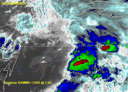
Trying to fire around the center but just too much shear still going on.
https://uploads.disquscdn.com/images/69b114faf868e7e6f7a02f633c914a599142747b4a178d27d72b0f0ffc912483.gif
https://uploads.disquscdn.com/images/69b114faf868e7e6f7a02f633c914a599142747b4a178d27d72b0f0ffc912483.gif
0 likes
The following post is NOT an official forecast and should not be used as such. It is just the opinion of the poster and may or may not be backed by sound meteorological data. It is NOT endorsed by any professional institution including storm2k.org For Official Information please refer to the NHC and NWS products.
-
CrazyC83
- Professional-Met
- Posts: 33393
- Joined: Tue Mar 07, 2006 11:57 pm
- Location: Deep South, for the first time!
ALBERTO - Preps, Obs, Webcams, Local Updates
Post anything local (such as NWS reports) or your own reports here.
0 likes

-
johngaltfla

- Category 5
- Posts: 1938
- Joined: Sun Jul 10, 2005 9:17 pm
- Location: Sarasota County, FL
- Contact:
Re: ATL: ALBERTO - Sub-Tropical Storm
ronjon wrote:Or is it just another vort spinning around the larger gyre? If it is a center reformation, ukie model was right.
The Ukie was pretty darned impressive with invests last year so if they tweaked it to improve it, I'll be curious to see comparisons to the other models once Alberto gets cranking.
1 likes

-
Twisted-core
- Category 1
- Posts: 252
- Joined: Fri May 11, 2018 9:20 pm
Re: ATL: ALBERTO - Models

0 likes
-
Evil Jeremy

- S2K Supporter

- Posts: 5459
- Age: 30
- Joined: Mon Apr 10, 2006 2:10 pm
- Location: Los Angeles, CA
Re: ATL: ALBERTO - Models
Twisted-core wrote:https://lab.weathermodels.com/models/tropical/AL01_current.png
https://i.imgur.com/hEaLhda.png?1
Looking locked and loaded.
Not often the models are in better agreement on what will happen in five days than in two days.
2 likes
Frances 04 / Jeanne 04 / Katrina 05 / Wilma 05 / Fay 08 / Debby 12 / Andrea 13 / Colin 16 / Hermine 16 / Matthew 16 / Irma 17


-
wxman57
- Moderator-Pro Met
- Posts: 22480
- Age: 66
- Joined: Sat Jun 21, 2003 8:06 pm
- Location: Houston, TX (southwest)
Re: ATL: ALBERTO - Sub-Tropical Storm
Not much convection left now. Winds well below TS strength. May not get going (TS winds) for another 24 hours or so when the shear starts to decrease.
2 likes
Who is online
Users browsing this forum: No registered users and 29 guests