CPAC: LANE - Post-Tropical

Moderator: S2k Moderators

Message
Author
Chris90
Category 2
Category 2
Posts: 637
Age: 34
Joined: Thu Jun 01, 2017 9:36 pm

Re: EPAC: LANE - Tropical Storm

#161 Postby Chris90 » Thu Aug 16, 2018 7:05 pm

Kingarabian wrote:Another fresh microwave pass, this time an SSMI F-15 shot, shows hints of a cyan ring. Which would be a strong precursor for rapid intensification:


I'm ready for Lane to close that eyewall and rapidly intensify. As long as it stays south of Hawaii. Hopefully this isn't another disappointment like Fabio and John. It seems to be becoming a theme this EPAC season of storms not living up to their potential. Microwave images do continue to improve though.
0 likes   
Solar Aquarian
Lunar Cancerian
:uarrow: Sagittarian

User avatar
cycloneye
Admin
Admin
Posts: 139068
Age: 67
Joined: Thu Oct 10, 2002 10:54 am
Location: San Juan, Puerto Rico

Re: EPAC: LANE - Tropical Storm

#162 Postby cycloneye » Thu Aug 16, 2018 7:48 pm

Not so fast? Best Track stays as 60 kts.

EP, 14, 2018081700, , BEST, 0, 110N, 1292W, 60, 997, T
0 likes   
Visit the Caribbean-Central America Weather Thread where you can find at first post web cams,radars
and observations from Caribbean basin members Click Here

User avatar
Kingarabian
S2K Supporter
S2K Supporter
Posts: 15434
Joined: Sat Aug 08, 2009 3:06 am
Location: Honolulu, Hawaii

Re: EPAC: LANE - Tropical Storm

#163 Postby Kingarabian » Thu Aug 16, 2018 8:28 pm

cycloneye wrote:Not so fast? Best Track stays as 60 kts.

EP, 14, 2018081700, , BEST, 0, 110N, 1292W, 60, 997, T


I'm not sure why. Eye is evident on microwave imagery and satellite estimates support an upgrade.
0 likes   
RIP Kobe Bryant

User avatar
DioBrando
Category 4
Category 4
Posts: 917
Age: 27
Joined: Sun Aug 12, 2018 12:45 pm

Re: EPAC: LANE - Tropical Storm

#164 Postby DioBrando » Thu Aug 16, 2018 8:31 pm

Kingarabian wrote:
cycloneye wrote:Not so fast? Best Track stays as 60 kts.

EP, 14, 2018081700, , BEST, 0, 110N, 1292W, 60, 997, T


I'm not sure why. Eye is evident on microwave imagery and satellite estimates support an upgrade.

surely the microwave imagery and best track time is the same or nah?
0 likes   
blonde stacey (xe/xem/xir)

ncapps
Tropical Storm
Tropical Storm
Posts: 105
Joined: Wed Aug 15, 2018 7:53 am

Re: EPAC: LANE - Tropical Storm

#165 Postby ncapps » Thu Aug 16, 2018 8:47 pm

Image

Eh.Crossing over into -130, lets see if that does the trick.
1 likes   

Chris90
Category 2
Category 2
Posts: 637
Age: 34
Joined: Thu Jun 01, 2017 9:36 pm

Re: EPAC: LANE - Tropical Storm

#166 Postby Chris90 » Thu Aug 16, 2018 9:04 pm

Kingarabian wrote:
cycloneye wrote:Not so fast? Best Track stays as 60 kts.

EP, 14, 2018081700, , BEST, 0, 110N, 1292W, 60, 997, T


I'm not sure why. Eye is evident on microwave imagery and satellite estimates support an upgrade.


I think it might have something to do with the fact ASCAT data hasn't been supporting the satellite estimates. Satellite estimates have been higher than what the past couple of ASCAT passes over the system showed.
Maybe the pressure gradient is broader than what is typical and it's holding the winds down a bit?
2 likes   
Solar Aquarian
Lunar Cancerian
:uarrow: Sagittarian

User avatar
galaxy401
Category 5
Category 5
Posts: 2299
Age: 28
Joined: Sat Aug 25, 2012 9:04 pm
Location: Casa Grande, Arizona

Re: EPAC: LANE - Hurricane

#167 Postby galaxy401 » Thu Aug 16, 2018 9:44 pm

They ended up upgrading.

BULLETIN
Hurricane Lane Advisory Number 9
NWS National Hurricane Center Miami FL EP142018
800 PM PDT Thu Aug 16 2018

...LANE BECOMES THE SIXTH HURRICANE OF THE 2018 PACIFIC SEASON...
...EXPECTED TO STRENGTHEN INTO A MAJOR HURRICANE BY SATURDAY...


SUMMARY OF 800 PM PDT...0300 UTC...INFORMATION
----------------------------------------------
LOCATION...11.2N 129.8W
ABOUT 1540 MI...2475 KM WSW OF THE SOUTHERN TIP OF BAJA CALIFORNIA
ABOUT 1780 MI...2865 KM ESE OF HILO HAWAII
MAXIMUM SUSTAINED WINDS...75 MPH...120 KM/H
PRESENT MOVEMENT...WNW OR 285 DEGREES AT 15 MPH...24 KM/H
MINIMUM CENTRAL PRESSURE...992 MB...29.30 INCHES
1 likes   
Got my eyes on moving right into Hurricane Alley: Florida.

User avatar
cycloneye
Admin
Admin
Posts: 139068
Age: 67
Joined: Thu Oct 10, 2002 10:54 am
Location: San Juan, Puerto Rico

Re: EPAC: LANE - Hurricane

#168 Postby cycloneye » Thu Aug 16, 2018 9:47 pm

galaxy401 wrote:They ended up upgrading.

BULLETIN
Hurricane Lane Advisory Number 9
NWS National Hurricane Center Miami FL EP142018
800 PM PDT Thu Aug 16 2018

...LANE BECOMES THE SIXTH HURRICANE OF THE 2018 PACIFIC SEASON...
...EXPECTED TO STRENGTHEN INTO A MAJOR HURRICANE BY SATURDAY...


SUMMARY OF 800 PM PDT...0300 UTC...INFORMATION
----------------------------------------------
LOCATION...11.2N 129.8W
ABOUT 1540 MI...2475 KM WSW OF THE SOUTHERN TIP OF BAJA CALIFORNIA
ABOUT 1780 MI...2865 KM ESE OF HILO HAWAII
MAXIMUM SUSTAINED WINDS...75 MPH...120 KM/H
PRESENT MOVEMENT...WNW OR 285 DEGREES AT 15 MPH...24 KM/H
MINIMUM CENTRAL PRESSURE...992 MB...29.30 INCHES


Hurricane Lane Discussion Number 9
NWS National Hurricane Center Miami FL EP142018
800 PM PDT Thu Aug 16 2018

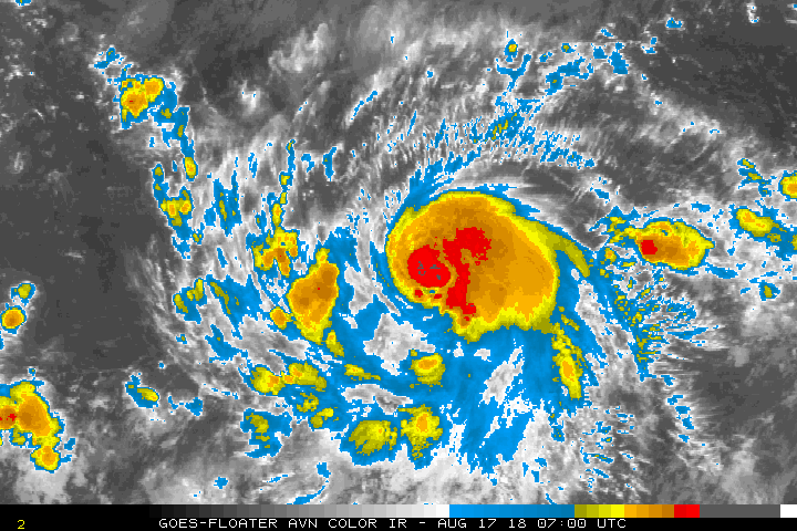
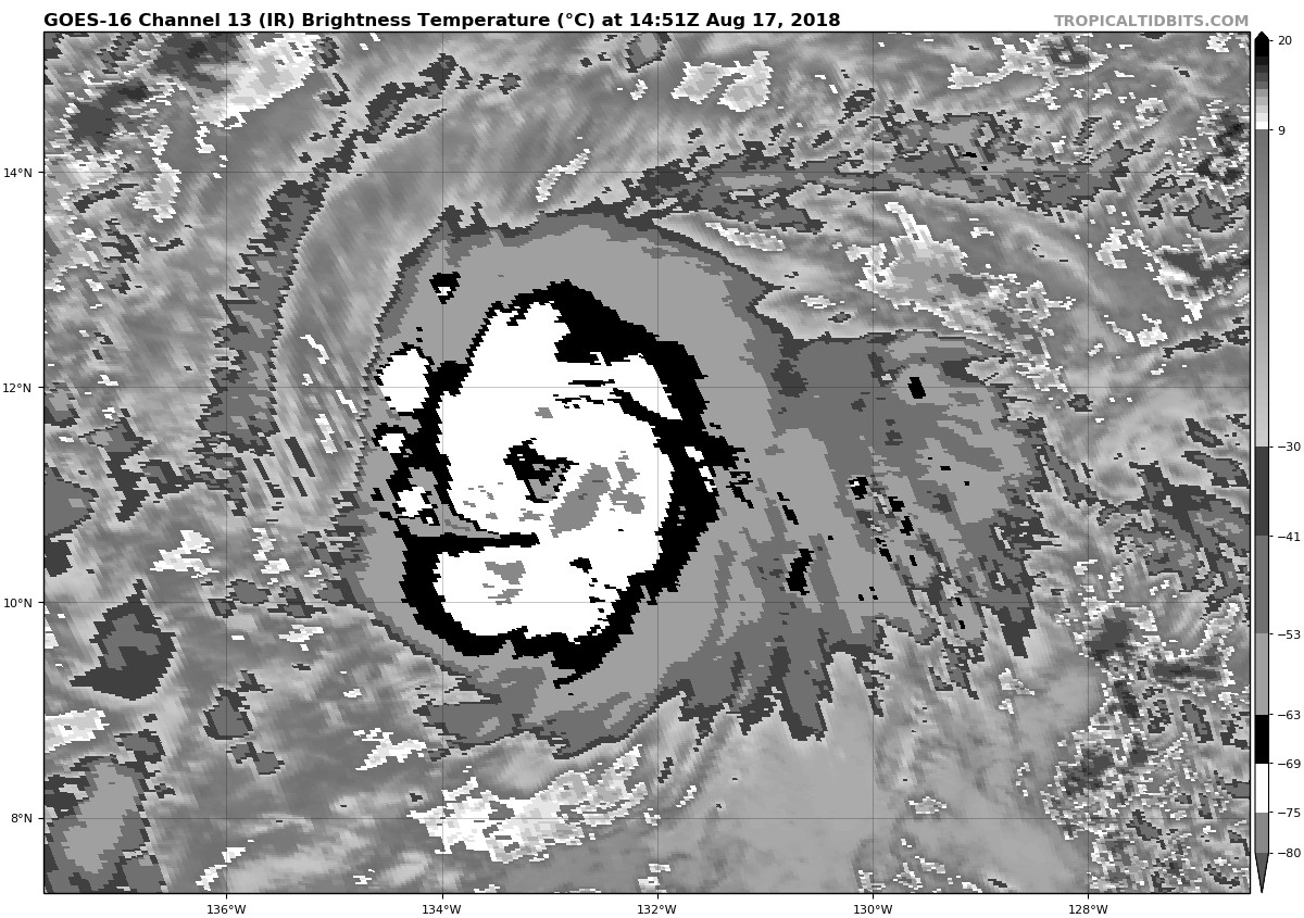
Visible, infrared, and microwave satellite imagery indicate that
Lane's overall cloud pattern has continued to improve, with several
spiral bands and a more symmetrical outflow pattern having
developed. Although the inner-core convection has deteriorated
somewhat until just recently due to the entrainment of dry air,
microwave images indicate that a well-defined inner-core and
low-level eye feature has formed. Satellite intensity estimates at
0000 UTC ranged form T4.0/65 kt from TAFB and SAB to 55 kt and 59 kt
from UW-CIMSS ADT and SATCON, respectively, which supported an
intensity of 60 kt at that time. Since then, however, a nearly
closed ring of cold-topped convection has developed near the center,
so the intensity is set at 65 kt at the advisory time.

Lanes has made a sharp jog toward the west-northwest during the past
6 hours, but this believed to be a short-term wobble due to the
convection having recently wrapped around the north side of the
low-level center. A return to a general westward motion of 280/13 kt
is expected to resume shortly. The latest model guidance remains in
good agreement on Lane continuing move between westward and
west-northwestward direction for the next 3-4 days, followed by a
turn back toward the west on day 5 as the stout subtropical ridge to
the north strengthens to the east and northeast of the Hawaiian
Islands and as a broad upper-level trough north of Hawaii gradually
lifts out toward the northeast. The new NHC forecast track has been
shifted a little to the right or north of the previous advisory
track, primarily due to the more northward initial position, and
closely follows the HCCA and TVCN/TVCE track consensus models.

Now that a small well-defined inner core and partial eye feature
have developed with a radius of maximum winds of 15-20 nmi, Lane is
poised to rapidly intensity shortly, and sustain that trend for the
next 36 hour so owing to the very low vertical-wind-shear and
warm-SST regime that the cyclone will be moving through. Although
brief intrusions of dry air may result in some flirtations in the
intensity, the general trend should be for Lane to strengthen at a
rate of at least 30 kt per 24 hours for the next 36-48 hours. After
that, the intensity will be modulated by inner-core/eyewall
fluctuations that can not be forecast accurately that far in
advance. By days 4 and 5, however, a slow weakening trend is
expected due to a gradual increase in southwesterly vertical wind
shear. Overall, though, the new NHC intensity forecast is a little
above the previous intensity forecast, and is above all of the
intensity guidance. A good analog that was used for Lane's forecast
was recent Hurricane Hector, which exhibited similar inner-core and
outflow characteristics, and moved through similar environmental and
oceanic conditions.

FORECAST POSITIONS AND MAX WINDS

INIT 17/0300Z 11.2N 129.8W 65 KT 75 MPH
12H 17/1200Z 11.5N 131.9W 75 KT 85 MPH
24H 18/0000Z 12.0N 134.9W 90 KT 105 MPH
36H 18/1200Z 12.5N 137.7W 105 KT 120 MPH
48H 19/0000Z 13.1N 140.3W 110 KT 125 MPH
72H 20/0000Z 14.4N 145.0W 110 KT 125 MPH
96H 21/0000Z 15.2N 149.2W 105 KT 120 MPH
120H 22/0000Z 15.6N 153.7W 95 KT 110 MPH

$$
Forecaster Stewart
0 likes   
Visit the Caribbean-Central America Weather Thread where you can find at first post web cams,radars
and observations from Caribbean basin members Click Here

ncapps
Tropical Storm
Tropical Storm
Posts: 105
Joined: Wed Aug 15, 2018 7:53 am

Re: EPAC: LANE - Hurricane

#169 Postby ncapps » Thu Aug 16, 2018 11:26 pm

Ridge really becomes firmly in control in latest 0Z GFS. Very similar to 12z Euro. This should shift the cone further West.
1 likes   

User avatar
Yellow Evan
Professional-Met
Professional-Met
Posts: 15951
Age: 25
Joined: Fri Jul 15, 2011 12:48 pm
Location: Henderson, Nevada/Honolulu, HI
Contact:

Re: EPAC: LANE - Hurricane

#170 Postby Yellow Evan » Fri Aug 17, 2018 1:45 am

17/0600 UTC 11.3N 130.5W T4.5/4.5 LANE -- East Pacific
0 likes   

User avatar
Kingarabian
S2K Supporter
S2K Supporter
Posts: 15434
Joined: Sat Aug 08, 2009 3:06 am
Location: Honolulu, Hawaii

Re: EPAC: LANE - Hurricane

#171 Postby Kingarabian » Fri Aug 17, 2018 1:45 am

Doing better, slowly but surely:

Image
2 likes   
RIP Kobe Bryant

User avatar
Kingarabian
S2K Supporter
S2K Supporter
Posts: 15434
Joined: Sat Aug 08, 2009 3:06 am
Location: Honolulu, Hawaii

Re: EPAC: LANE - Hurricane

#172 Postby Kingarabian » Fri Aug 17, 2018 2:38 am

TXPZ25 KNES 170627
TCSENP

A. 14E (LANE)

B. 17/0600Z

C. 11.3N

D. 130.5W

E. THREE/GOES-E

F. T4.5/4.5/D1.0/24HRS

G. IR/EIR/SWIR/GMI

H. REMARKS...CENTER EMBEDDED IN B YIELDS A DT OF 5.0. MET AND PT ARE
4.5. FT IS BASED ON MET.

I. ADDL POSITIONS

17/0521Z 11.3N 130.5W GMI


...RAMIREZ
0 likes   
RIP Kobe Bryant

User avatar
Cyclenall
Category 5
Category 5
Posts: 6627
Joined: Thu Jun 08, 2006 10:01 pm
Location: Ontario, Canada

Re: EPAC: LANE - Tropical Storm

#173 Postby Cyclenall » Fri Aug 17, 2018 2:59 am

Chris90 wrote:I'm ready for Lane to close that eyewall and rapidly intensify. As long as it stays south of Hawaii. Hopefully this isn't another disappointment like Fabio and John. It seems to be becoming a theme this EPAC season of storms not living up to their potential. Microwave images do continue to improve though.

That's why I waited until the end of the day to check up on Lane. It appears I made the right call.
0 likes   

User avatar
Kingarabian
S2K Supporter
S2K Supporter
Posts: 15434
Joined: Sat Aug 08, 2009 3:06 am
Location: Honolulu, Hawaii

Re: EPAC: LANE - Hurricane

#174 Postby Kingarabian » Fri Aug 17, 2018 3:33 am

This latest low resolution AMSU pass shows the core completely closed and at this rate I expect the eye to clear out soon.

Image
0 likes   
RIP Kobe Bryant

User avatar
Kingarabian
S2K Supporter
S2K Supporter
Posts: 15434
Joined: Sat Aug 08, 2009 3:06 am
Location: Honolulu, Hawaii

Re: EPAC: LANE - Hurricane

#175 Postby Kingarabian » Fri Aug 17, 2018 3:48 am

Gradually losing it's banding features, which will help it a lot in the long run.

Image

00z package was very good news for Hawaii. That being said, it's still about 7-8 days before Lane enters our vicinity.

NHC in its latest discussion says there's some uncertainty in how much Lane will be influenced by the trough off of Baja California. Which in turn means there'll be uncertainty in how far west Lane goes while in the CPAC before recurving.
0 likes   
RIP Kobe Bryant

User avatar
cycloneye
Admin
Admin
Posts: 139068
Age: 67
Joined: Thu Oct 10, 2002 10:54 am
Location: San Juan, Puerto Rico

Re: EPAC: LANE - Hurricane

#176 Postby cycloneye » Fri Aug 17, 2018 5:01 am

Hurricane Lane Discussion Number 10
NWS National Hurricane Center Miami FL EP142018
200 AM PDT Fri Aug 17 2018

Lane continues to gradually strengthen. Recent microwave images
show a well-defined low-level eye, but this feature is not yet
apparent in geostationary satellite images. The latest
satellite images show an organized central dense overcast, but
convection has decreased in the outer bands. An average of the
Dvorak estimates from TAFB and SAB yields an initial intensity of 70
kt.

The environmental factors suggest that continued steady or rapid
strengthening is likely during the next couple of days. However,
there could be some intrusions of dry air that might interrupt the
rate of strengthening. Nonetheless, it seems likely that Lane will
become a major hurricane within the next couple of days. By the end
of the forecast period, the environment looks a little less ideal
with drier air and an increase in shear likely causing slow
weakening. The NHC intensity forecast is largely an update of the
previous one, and it remains at the high end of the model guidance.

After wobbling to the north late yesterday, Lane has resumed a more
westward motion at 14 kt. The hurricane is expected to move
westward to west-northwestward during the next several days as it
continues to be steered by a subtropical ridge to its north. There
is some north-south spread amongst the models with the UKMET on the
southern side of the guidance and the GFS and HWRF on the northern
side. This spread appears to be associated with how much influence
a mid- to upper-level low off the Baja California coast has on
Lane's steering flow. The NHC track forecast lies near the middle
of the guidance envelope, favoring the various consensus models, and
is slightly to the left of the previous forecast track. Lane is
expected to cross into the Central Pacific basin in 36 to 48 hours.

The initial 34-kt and 50-kt wind radii have been adjusted outward
based on a 0544 UTC ASCAT-B pass.

FORECAST POSITIONS AND MAX WINDS

INIT 17/0900Z 11.4N 131.4W 70 KT 80 MPH
12H 17/1800Z 11.8N 133.6W 80 KT 90 MPH
24H 18/0600Z 12.2N 136.6W 95 KT 110 MPH
36H 18/1800Z 12.7N 139.4W 105 KT 120 MPH
48H 19/0600Z 13.4N 141.9W 110 KT 125 MPH
72H 20/0600Z 14.5N 146.5W 105 KT 120 MPH
96H 21/0600Z 15.0N 150.7W 100 KT 115 MPH
120H 22/0600Z 15.5N 155.3W 90 KT 105 MPH

$$
Forecaster Cangialosi
0 likes   
Visit the Caribbean-Central America Weather Thread where you can find at first post web cams,radars
and observations from Caribbean basin members Click Here

ncapps
Tropical Storm
Tropical Storm
Posts: 105
Joined: Wed Aug 15, 2018 7:53 am

Re: EPAC: LANE - Hurricane

#177 Postby ncapps » Fri Aug 17, 2018 9:07 am

This mornings SWIR imagery really shows the eye trying to form. lane also looks more compact with a tighter pressure gradient. Intensification should be fun to watch today as the rate 'should' be fast.

Movement is almost due west still, seems a bit ahead of the GFS is terms of speed at this time, but nothing substantial.
1 likes   

Ntxw
Storm2k Moderator
Storm2k Moderator
Posts: 21501
Joined: Wed Oct 21, 2009 6:34 pm
Location: DFW, Texas

Re: EPAC: LANE - Hurricane

#178 Postby Ntxw » Fri Aug 17, 2018 9:20 am

He has taken his sweet time, but almost there.

UW - CIMSS
ADVANCED DVORAK TECHNIQUE
ADT-Version 9.0
Tropical Cyclone Intensity Algorithm

----- Current Analysis -----
Date : 17 AUG 2018 Time : 130000 UTC
Lat : 11:19:59 N Lon : 132:19:47 W


CI# /Pressure/ Vmax
4.4 / 983.2mb/ 74.6kt


Final T# Adj T# Raw T#
4.4 4.4 5.7

Estimated radius of max. wind based on IR :N/A km

Center Temp : -19.5C Cloud Region Temp : -64.9C

Scene Type : EYE


Image
1 likes   
The above post and any post by Ntxw is NOT an official forecast and should not be used as such. It is just the opinion of the poster and may or may not be backed by sound meteorological data. It is NOT endorsed by any professional institution including Storm2k. For official information, please refer to NWS products.

  Help support Storm2K!
Help Support Storm2K

Ntxw
Storm2k Moderator
Storm2k Moderator
Posts: 21501
Joined: Wed Oct 21, 2009 6:34 pm
Location: DFW, Texas

Re: EPAC: LANE - Hurricane

#179 Postby Ntxw » Fri Aug 17, 2018 10:14 am

UW - CIMSS
ADVANCED DVORAK TECHNIQUE
ADT-Version 9.0
Tropical Cyclone Intensity Algorithm

----- Current Analysis -----
Date : 17 AUG 2018 Time : 140000 UTC
Lat : 11:11:23 N Lon : 132:41:24 W


CI# /Pressure/ Vmax
4.6 / 979.7mb/ 79.6kt


Final T# Adj T# Raw T#
4.6 5.5 6.2

Estimated radius of max. wind based on IR :N/A km

Center Temp : -10.7C Cloud Region Temp : -68.7C

Scene Type : EYE


Image

Not the best viewing angle but going past 130W seems to have done the trick. Sun is coming up that way and should get some decent visible soon.
0 likes   
The above post and any post by Ntxw is NOT an official forecast and should not be used as such. It is just the opinion of the poster and may or may not be backed by sound meteorological data. It is NOT endorsed by any professional institution including Storm2k. For official information, please refer to NWS products.


  Help support Storm2K!

Help Support Storm2K


User avatar
DioBrando
Category 4
Category 4
Posts: 917
Age: 27
Joined: Sun Aug 12, 2018 12:45 pm

Re: EPAC: LANE - Hurricane

#180 Postby DioBrando » Fri Aug 17, 2018 10:22 am

lane's a 2 now

expected to become a 4

o o f y

561
WTPZ44 KNHC 171455
TCDEP4

Hurricane Lane Discussion Number 11
NWS National Hurricane Center Miami FL EP142018
800 AM PDT Fri Aug 17 2018

Lane's cloud pattern has improved significantly this morning, and
the cyclone is currently undergoing rapid intensification. A
warming ragged eye is now evident in GOES-17 IR BD-curve
enhancement, and a white curved band with cold tops of -70 to -75C
wraps about 90% around the cyclone's circulation. The Dvorak
satellite intensity estimates from TAFB and SAB, and the objective
analysis support an increase of the wind speed to 85 kt for this
advisory.

Lane appears poised for further rapid strengthening during
the next 24 hours. Impressive outflow in all quadrants, warm SSTs,
and the absence of earlier noted dry air intrusion all point to this
scenario. The peak intensity based on the hurricane models and the
statistical guidance is forecast to be within the next 24-36
hours. Afterward, the thermodynamic environment looks a little
less conducive and the large-scale models as well as the
statistical intensity guidance agree that increasing westerly
vertical shear will induce a slow weakening trend. The official
forecast is above the guidance during the first 36 hours, but is
close to the HMON hurricane model, and is hedged toward a blend of
the HCCA and IVCN intensity consensus models through the remaining
portion of the forecast.

The initial motion is estimated to be nearly due west, or 275/14 kt.
Lane should continue to move south of a subtropical ridge in either
a westward or west-northwestward direction through the entire
forecast period. The NHC forecast is basically an update of the
previous one with just a slight adjustment to the south, and is very
close to the TVCN and NOAA HCCA consensus models.


FORECAST POSITIONS AND MAX WINDS

INIT 17/1500Z 11.2N 132.9W 85 KT 100 MPH
12H 18/0000Z 11.6N 135.0W 100 KT 115 MPH
24H 18/1200Z 12.1N 137.9W 115 KT 130 MPH
36H 19/0000Z 12.6N 140.7W 115 KT 130 MPH
48H 19/1200Z 13.3N 143.3W 105 KT 120 MPH
72H 20/1200Z 14.3N 147.6W 95 KT 110 MPH
96H 21/1200Z 14.8N 151.8W 90 KT 105 MPH
120H 22/1200Z 15.3N 155.9W 80 KT 90 MPH

$$
Forecaster Roberts
1 likes   
blonde stacey (xe/xem/xir)


Return to “2018”

Who is online

Users browsing this forum: No registered users and 96 guests